MAHA TET Exam  >  MAHA TET Tests  >  MH SET Paper 2 Mock Test - 4 (Geography) - MAHA TET MCQ

MH SET Paper 2 Mock Test - 4 (Geography) - MAHA TET MCQ


Test Description

30 Questions MCQ Test - MH SET Paper 2 Mock Test - 4 (Geography)

MH SET Paper 2 Mock Test - 4 (Geography) for MAHA TET 2024 is part of MAHA TET preparation. The MH SET Paper 2 Mock Test - 4 (Geography) questions and answers have been prepared according to the MAHA TET exam syllabus.The MH SET Paper 2 Mock Test - 4 (Geography) MCQs are made for MAHA TET 2024 Exam. Find important definitions, questions, notes, meanings, examples, exercises, MCQs and online tests for MH SET Paper 2 Mock Test - 4 (Geography) below.
Solutions of MH SET Paper 2 Mock Test - 4 (Geography) questions in English are available as part of our course for MAHA TET & MH SET Paper 2 Mock Test - 4 (Geography) solutions in Hindi for MAHA TET course. Download more important topics, notes, lectures and mock test series for MAHA TET Exam by signing up for free. Attempt MH SET Paper 2 Mock Test - 4 (Geography) | 100 questions in 120 minutes | Mock test for MAHA TET preparation | Free important questions MCQ to study for MAHA TET Exam | Download free PDF with solutions
MH SET Paper 2 Mock Test - 4 (Geography) - Question 1

Which one of the following components is not taken into consideration by the Environmental Pollution Assessment (EPA) of US to calculate the Air Quality Index (AQI)?

Detailed Solution for MH SET Paper 2 Mock Test - 4 (Geography) - Question 1

The air quality index (AQI) is an index for reporting air quality on a daily basis. It is a measure of how air pollution affects one's health within a short time period. The purpose of the AQI is to help people know how the local air quality impacts their health. The higher the AQI value, the greater the level of air pollution and the greater the health concerns. AQI quickly disseminates air quality information in real-time.​
The Environmental Protection Agency (EPA) calculates the AQI for five major air pollutants, for which national air quality standards have been established to safeguard public health.

1. Ground-level ozone
2. Particle pollution/particulate matter (PM2.5/pm 10)

3. Carbon Monoxide
4. Sulfur dioxide
5. Nitrogen dioxide

Additional Information

Air Quality Index Categories

  • Good (0–50) - Minimal Impact
  • Satisfactory (51–100) - May cause minor breathing difficulties in sensitive people.
  • Moderately polluted (101–200) - May cause breathing difficulties in people with lung disease like asthma, and discomfort to people with heart disease, children and older adults.
  • Poor (201–300) - May cause breathing difficulties in people on prolonged exposure, and discomfort to people with heart disease 
  • Very Poor (301–400) - May cause respiratory illness in people on prolonged exposure. Effect may be more pronounced in people with lung and heart diseases.
  • Severe (401-500) - May cause respiratory issues in healthy people, and serious health issues in people with lung/heart disease. Difficulties may be experienced even during light physical activity.
MH SET Paper 2 Mock Test - 4 (Geography) - Question 2

Who was the first scholar who divided the world landmass into three continents-Europe, Asia and Libya(Africa)?

Detailed Solution for MH SET Paper 2 Mock Test - 4 (Geography) - Question 2

The correct answer is Herodotus.

Herodotus is credited with being the first person to divide the world's landmass into three continents: Europe, Asia, and Libya (Africa).

Key Points

  • The ancient Greek philosopher and geographer, Herodotus, is credited with being the first person to divide the world's landmass into three continents: Europe, Asia, and Libya (Africa).
  • He did this in his work "Histories," which was written in the 5th century BCE.
  • In this work, Herodotus described his travels and the customs and cultures of the people he encountered.
  • He also provided the first known geographical and ethnographical description of the world as known to the Greeks of his time.
  • He used the terms
    • "Europe" refers to the lands north of the Mediterranean Sea and the Aegean Sea,
    • "Asia" refers to the lands east of the Aegean Sea and
    • "Libya" refers to the African continent.

1 Crore+ students have signed up on EduRev. Have you? Download the App
MH SET Paper 2 Mock Test - 4 (Geography) - Question 3

Read the following statements and choose correct answer from the code given below:

(a) El Nino current contributes to the global warming.

(b) El Nino is also associated with droughts in Australia.

(c) El Nino is a cold current.

(d) El Nino was discovered in the nineteenth century.

Code:

Detailed Solution for MH SET Paper 2 Mock Test - 4 (Geography) - Question 3

The El Nino is warm water current that flows from Papua New Guinea towards Peru. It occurs every 3 to 8 years. It is considered to be one of the causes of global warming and also leads to droughts in Australia. It was discovered in the seventeenth century.

Thus, the correct answer is A.

MH SET Paper 2 Mock Test - 4 (Geography) - Question 4

Match the following:-

Choose the correct option:

Detailed Solution for MH SET Paper 2 Mock Test - 4 (Geography) - Question 4
  • The Atlantic Ocean has several great canyons. Among them, the Fosse de Cape Breton canyon is one that is found along the western continental shelves of the European continent. It lies on the floor of the Bay of Biscay, near the coast of south-western France. The canyon is in front of an old river, Adour.
  • The Pacific Ocean has about 32 deeps, among which most of them are trenches. The Tonga Kermadec trench is a trough like depression extending from north east to south west along the Tonga and Kermadec islands. They are measured to be 8000m deep.
  • The Mediterranean Sea has deep elongated basins which extend from east to west. Because of a ridge the sea is divided into western and eastern parts. The Algiers-Provencal basin lies in the western part of the western Mediterranean. This basin is bound by 2700m contour showing deepest areas not crossing 2900m.
  • The Indian Ocean is also divided by the central ridge into several basins. Among them the Cocos-Keeling basin is the most extensive basin found on the eastern side of the central ridge, extending from 10-degree N to 50-degree S. The average depth ranges from 2000-4000m. This basin is also known as the Indo-Australian Basin.
MH SET Paper 2 Mock Test - 4 (Geography) - Question 5
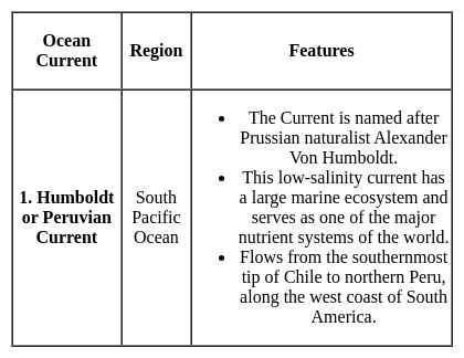
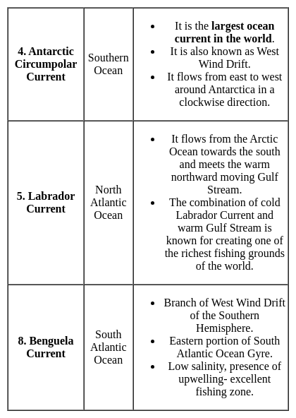
Which one of the following is NOT a current of the Atlantic Ocean?
Detailed Solution for MH SET Paper 2 Mock Test - 4 (Geography) - Question 5

The correct answer is Agulhas Current.

 Key Points

  • Agulhas current is a warm current flows south along east Coast of Africa in Southwest Indian ocean.
  • Benguela current is a cold current flows along the coast of South Africa, Namibia, and Angola. 
  • Brazilian current is a warm current flows along the east coast of Brazil, Uruguay and Argentina.
  • Canaries current is a cold current present between Fram strait and cape farewell in North Atlantic ocean.

Additional Information

  • Ocean current is a massive movement of ocean water that is caused and influenced by various forces.
  • Forces responsible for the ocean currents are wind, gravity, Coriolis force, heating by solar energy, water density and temperature of the water.
  • Mainly, ocean currents are classified into two types. they are cold currents and warm currents
    • Cold currents bring cold water into warm water areas usually found on the west coast of the continents.
    • Warm currents bring warm water into cold water areas usually found on the east coast of continents. 
MH SET Paper 2 Mock Test - 4 (Geography) - Question 6
Consider the following statements-

a) Troposphere is also known as the convective region.

b) The Stratosphere is referred to as the point from where the decrease of temperature stops.

c) The most destructive gases that lower the effectiveness of the ozone are known as CFCs.

d) The three layers that fall under the Heterosphere are mesosphere, ionosphere, and exosphere.

Which of the following statements are correct?

Detailed Solution for MH SET Paper 2 Mock Test - 4 (Geography) - Question 6

Troposphere is marked by turbulence and eddies. It is called as the convective region as all the convective activities cease at the upper limit of the troposphere. Various forms of clouds, thunderstorms, cyclones and anticyclones occur in this sphere because of the concentration of almost all the water vapour and aerosols in it.

CFCs or Chlorofluorocarbons are synthetic chemicals which, used as propellants, are released in the air and transported in the stratosphere by vertical atmospheric circulation. Chlorine when separated from CFCs reacts with water and thus depletes ozone rather breaks ozone into O2 and O.

MH SET Paper 2 Mock Test - 4 (Geography) - Question 7
How many satellites in orbit are required for the functioning for the NavIC system and provide accurate real-time positioning service?
Detailed Solution for MH SET Paper 2 Mock Test - 4 (Geography) - Question 7

For the NavIC system to provide real-time position and timing, three IRNSS satellites are in the geostationary orbits and the other four satellites are in geosynchronous orbits with required inclination.

Thus, the Correct answer is A.

MH SET Paper 2 Mock Test - 4 (Geography) - Question 8

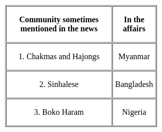
Consider the following pairs :

Which of the pairs given above is/are correctly matched?

Detailed Solution for MH SET Paper 2 Mock Test - 4 (Geography) - Question 8

The correct answer is 3 only.

Key Points

Boko Haram

  • It is the militant group in northern Nigeria that has killed tens of thousands of people and displaced more than 3 million people. Hence, Pair 3 is correctly matched.
  • Boko Haram militants mainly inhabit areas in the northern states of Nigeria, specifically Yobe, Kano, Bauchi, Borno and Kaduna.
  • Boko Haram means "Western education is forbidden." The group was founded in 2002.

Sinhalese

  • It is also spelt Singhalese or Cingalese, a member of the people of Sri Lanka (formerly Ceylon) who constitute the largest ethnic group on that island. Hence, Pair 2 is not correctly matched.
  • In the early 21st century the Sinhalese were estimated to number about 13.8 million, or 73 per cent of the population.
  • Their ancestors are believed to have come from northern India, traditionally in the 5th century BCE.
  • Their language belongs to the Indo-European family.

Chakmas and Hajongs

  • The Chakmas and Hajongs of Arunachal Pradesh are migrants from the Chittagong Hill Tracts of erstwhile East Pakistan, now Bangladesh. Hence, Pair 1 is not correctly matched.
  • Displaced by the Kaptai dam on the Karnaphuli River in the 1960s, they sought asylum in India.
  • They settled in relief camps in the southern and south-eastern parts of Arunachal Pradesh from 1964 to 1969.
  • A majority of them live in the Changlang district of the State today.
  • Mizoram and Tripura have a sizeable population of the Buddhist Chakmas while the Hindu Hajongs mostly inhabit the Garo Hills of Meghalaya and adjoining areas of Assam.
MH SET Paper 2 Mock Test - 4 (Geography) - Question 9

According to Malthus, what are preventive checks in the context of population control?

Detailed Solution for MH SET Paper 2 Mock Test - 4 (Geography) - Question 9

Option 2) Measures taken by individuals to control their own reproduction.

Thomas Malthus was an English economist and demographer who developed the Malthusian Theory of Population in the late 18th century. Malthus believed that population growth was exponential, while the growth of resources was arithmetic. This meant that population growth would eventually outstrip the growth of resources, leading to famine, disease, and other social problems.

Key Points

Measures taken by individuals to control their own reproduction.

  • This is a correct definition of preventive checks.
  • Preventive checks are measures that individuals take to control their own reproduction, such as birth control, late marriage, and abstinence.
  • Malthus also believed that there were two types of checks on population growth: preventive checks and positive checks.
  • Preventive checks are measures that individuals take to control their own reproduction, while positive checks are factors that limit population growth, such as famine, disease, and war.

Additional Information

  • Natural phenomena limiting population growth.

This is not a correct definition of preventive checks. Natural phenomena are positive checks on population growth, not preventive checks.

  • Technological advancements in agriculture.

This is not a correct definition of preventive checks. Technological advancements in agriculture can increase the growth of resources, but they do not prevent population growth.

  • Positive checks on population growth.

This is not a correct definition of preventive checks. Positive checks are factors that limit population growth, such as famine, disease, and war. Preventive checks are measures that individuals take to control their own reproduction.

Important Points

  • Malthus believed that preventive checks were more effective than positive checks in controlling population growth.
  • He argued that positive checks were often brutal and inhumane, while preventive checks were voluntary and more likely to be accepted by individuals.
MH SET Paper 2 Mock Test - 4 (Geography) - Question 10

Which of the following statements regarding the Mediterranean and Monsoon climate is/are correct?

1. Precipitation in the Mediterranean climate is in winter while in Monsoon climate it is mostly in summer.
2. The annual range of temperature in the Mediterranean climate is higher than the Monsoon climate.
3. Rainy and dry seasons are found in both the climates.

Select the correct answer using the code given below:
Detailed Solution for MH SET Paper 2 Mock Test - 4 (Geography) - Question 10

Correct Option- (c)

  • Mediterranean climate is known for hot, dry summers and mild to cool wet winters.
  • During the summer, cold currents keep the climate dry and when the season changes, ocean current shifts too. Hence, during the winter, the water having been warmed up in summer moves in and keep the land warn and often brings rain.
  • Hence, the annual range of temperature in the Mediterranean climate is lesser than that of Monsoon Climate.
MH SET Paper 2 Mock Test - 4 (Geography) - Question 11

Which of the following are true about the paradigm shift in Geography?

(A) It is a usual and accepted way of thinking about something that changes completely

(B) New paradigms brought adverse degradation of human efforts and morals

(C) Paradigm shift majorly focuses on the historical perspective

(D) Khun introduced the stages of development of a new paradigm

Choose the correct answer from the options given below:
Detailed Solution for MH SET Paper 2 Mock Test - 4 (Geography) - Question 11

Correct Answer: (A) and (D) only.

Key Points

  • The term paradigm was coined by S. Thomas Kuhn (1922-1996), an American historian of science while postulating a very important theory about the growth and development of science.
  • Distinct paradigm shifts have been taking place in both Geographical Research and Geospatial Technology through Digitalization.
  • The large growing population of the world requires a logical and scientific shift in both pure and applied research in the domain of geography.
  • Accordingly, a paradigm shift is defined as "an important change that happens when the usual way of thinking about or doing something is replaced by a new and different way."
  • The term paradigm was coined by S. Thomas Kuhn (1922-1996), an American historian of science while postulating a very important theory about the growth and development of science.
  • Kuhn (1962) defined ‘paradigm’ as the entire constellation of beliefs, values, techniques, and so on shared by the members of a given community.’
  • The Kuhn Cycle is a simple cycle of progress described by Thomas Kuhn in 1962 in his seminal work The Structure of Scientific Revolutions.
  • In Structure Kuhn challenged the world's current conception of science, which was a steady progression of the accumulation of new ideas.
  • In a brilliant series of reviews of past major scientific advances, Kuhn showed this viewpoint was wrong.
  • Science advanced the most by occasional revolutionary explosions of new knowledge, each revolution triggered by the introduction of new ways of thought so large they must be called new paradigms.

Additional Information

  • Recently, an integrating approach is a new paradigm in geography.
  • The main concern of recent geographical research is the perception of the environment, location, and geographical space.
  • The spatial dimension is an important aspect of the social epistemology geography (Science of space).
  • Consideration of space is required to understand the concept of integration and analysis of spatial patterns and processes.
  • The Geoinformatics paradigm in the 21st century is actually reflective of the concept of integration in terms of cartography, Geodesy, photogrammetry, spatial analysis, web mapping, global navigation satellite system, etc.
MH SET Paper 2 Mock Test - 4 (Geography) - Question 12

The earliest arrivals in India are believed to be Negritos. At which one of the following places are they mainly found now?

Detailed Solution for MH SET Paper 2 Mock Test - 4 (Geography) - Question 12

The earliest arrivals in India are believed to be Negritos. At Andaman Islands they are mainly found now. The Andaman Islands are home to four 'Negrito' tribes – the Great Andamanese, Onge, Jarawa and Sentinelese. The Nicobar Islands are home to two 'Mongoloid' tribes – the Shompen and Nicobarese. The 'Negrito' tribes are believed to have arrived in the islands from Africa up to 60,000 years ago.

MH SET Paper 2 Mock Test - 4 (Geography) - Question 13

Which one of the following industries would be found in the traditional industrial region?

Detailed Solution for MH SET Paper 2 Mock Test - 4 (Geography) - Question 13

Industries like Cotton Textile Industries, Iron and Steel industries, Sugar industries are characterized by higher proportion of workers in semi-skilled categories, using old obsolete technology, causing huge pollution unlike modern high tech industries. IT industries and the knowledge-based industries do not fall under traditional large-scale industries.

MH SET Paper 2 Mock Test - 4 (Geography) - Question 14
______ is an equatorial belt of low atmospheric pressure where the trade winds converge.
Detailed Solution for MH SET Paper 2 Mock Test - 4 (Geography) - Question 14

The correct answer is Doldrums.

  • Doldrums is an equatorial belt of low atmospheric pressure where the trade winds converge.

Key Points

Moraine

  • Moraines are distinct ridges or mounds of debris that are directly laid down by a moving glacier. This material is usually soil and rock.
  • Moraines only show up in places that have, or used to have glaciers.
  • Glaciers are extremely large, moving rivers of ice.
  • Glaciers shape the landscape in a process called glaciation.
  • Glaciation can affect the land, rocks, and water in an area for thousands of years. That is why moraines are often very old.

La Nina

  • La Nina is a climate pattern that describes the cooling of surface ocean waters along the tropical west coast of South America.
  • La Nina is the counterpart of El Nino.
  • La Lina means Little Girl in Spanish.
  • La Lina occurs at irregular intervals of about two to seven years.
  • La Niña is caused by a build-up of cooler-than-normal waters in the tropical Pacific, the area of the Pacific Ocean between the Tropic of Cancer and the Tropic of Capricorn.
  • Unusually strong, eastward-moving trade winds and ocean currents bring this cold water to the surface, a process known as upwelling.

El Nino

  • El Nino is a climate pattern that describes the unusual warming of surface waters in the eastern tropical Pacific Ocean.
  • El Nino means Christ child or Littel Boy in Spanish
  • During the time of El Nino, the trade winds weaken and warm water pushed back east towards the coast of Latin American countries.
  • El Nino can affect our weather significantly and trade winds.
  • El Nino has a strong effect on marine life off the Pacific coast.

Additional Information

  • Atmospheric Pressure belts are seasonally identical horizontal pressure variations created in the earth's atmosphere just above the earth's surface due to seasonal and spatial variation of energy received by the earth at different places.
  • There are seven pressure belts on the earth's surface. They are the Equatorial Low, the two Subtropical highs, the two Subpolar lows, and the two Polar highs. Except for the Equatorial low, the others form matching pairs in the Northern and Southern Hemispheres.

Equatorial Low-Pressure Belts

  • It is located on either side of the North and South of the Equator in a zone extending from 0o to 5o.
  • It is thermally induced because of the intense heating of the ground by the vertical rays of the sun.
  • It represents the zone convergence of North-East and South-East trade winds. This convergence zone is characterized by light and feeble winds and because of the frequent calm conditions, this belt is also called a belt of calm or doldrums.

Subtropical High-Pressure Belts

  • It extends between 30o to 35o both the hemisphere
  • It is not thermally induced but dynamically induced as it owes its origin to the rotation of the earth and sinking and settling down of winds.
  • Here the zone convergence of winds at a higher altitude above this zone results in the subsidence of air from higher altitudes and this wind results in high pressure. This zone of high pressure is also called the Horse latitude.
  • The permanent winds blowing from the Sub-Polar High-Pressure to Sub-Polar Low-Pressure in both the hemisphere are called Westerlies.

Sub-Polar Low-Pressure Belts

  • It extends between 60o and 65o in both the hemisphere.
  • The low-pressure belt does not thermally induce because there is low temperature throughout the year and as such there should have been a high-pressure belt instead of low pressure.
  • Pressure gradient, rotation of the earth and Coriolis force, centrifugal action of wind are the factor that controls the air motion.
  • This region is marked by violent storms in winter.

Polar High-Pressure Belts

  • Polar high pressure is very small in area and extends between 70o to 90oin both the hemisphere.
  • The temperatures are always extremely low.
  • The Polar regions experience very cold climatic conditions due to the rays of the sun is extremely slanting.
  • These regions of Polar high-pressure belts are known as the Polar Highs.
  • These regions are characterized by permanent IceCaps.

MH SET Paper 2 Mock Test - 4 (Geography) - Question 15
Given below are two statements- one is labelled as Assertion (A) and the other is labelled as Reason (R):

Assertion (A)- Red Sea has a salinity of 40 ppt.

Reason (R)- The salinity is greatly influenced by the difference between evaporation and precipitation as well as sea water movement.

Choose the correct option:

Detailed Solution for MH SET Paper 2 Mock Test - 4 (Geography) - Question 15

As we all know, the Evaporation, precipitation and some other are prime driving factors that are responsible for the spatial and regional distribution of sea and ocean water. In the partially enclosed seas of the Indian Ocean at the head of the Persian Gulf the salinity is 37ppt. whereas in the interior it amounts to 40.0ppt. The Red Sea, however, records the highest salinity among the enclosed seas because of high evaporation, less precipitation and mixture of the runoff water from the land.

MH SET Paper 2 Mock Test - 4 (Geography) - Question 16
Western disturbances are extratropical storms that bring sudden winter rain to the northern parts of India. They originate in ______.
Detailed Solution for MH SET Paper 2 Mock Test - 4 (Geography) - Question 16

The correct answer is the Mediterranean Sea.

Key PointsWestern disturbances are extratropical storms that bring sudden winter rain to the northern parts of India. They originate in the Mediterranean Sea

Western Disturbances

  • Western Disturbances form in the mid-latitude area, situated north of the Tropic of Cancer. This is why they are referred to as mid-latitude storms or extra-tropical storms
  • Western Disturbances are low-pressure systems, embedded in western winds (westerlies)  that flow from west to east.

Arrival in India

  • Western Disturbances begin is a low-pressure system that originates in the Mid-latitude region near the Atlantic Ocean and Europe.
  • The low pressure typically forms over the Mediterranean Sea and travels over Iran, Iraq,  Afghanistan, and Pakistan before entering India loaded with moisture.
  • These moisture-laden western disturbances eventually come up against the Himalayas and get blocked, as a consequence, the moisture gets trapped and precipitation is shared in the form of snow and rain over Northwest India and other parts of North India. 
  • An average of 4-5 western disturbances form during the winter season and the rainfall distribution and amount varies with every western disturbance.
  • The word 'Western' refers to the direction from which they originate in India.
  • The word 'disturbance' is used because the air within the low-pressure systems tends to be unstable or disturbed.
  • When western disturbances become more intense in the Indian Region, they can extend even up to 15 degrees north, resulting in rainfall up to north Maharashtra,  Gujarat, and the entire Madhya Pradesh to the south.

Impact

  • Western Disturbances are the cause of most winter and pre-monsoon season rainfall across North-West India.
  • This phenomenon is usually associated with a cloudy sky, higher night temperatures, and unusual rain.
  • It is estimated that India gets close to 5-10% of its total annual rainfall from western disturbances.
  • In winter, western winds bring moderate to heavy rain in low-lying areas and heavy snow to mountainous areas of the Indian subcontinent. 
  • India is a rain-dependent country and while the southwest monsoon covers most of India, parts of North India don’t get much rain from it.
  • These regions depend upon snow and rain from western disturbances during the winter season from November to March.
  • Precipitation during the winter season has great importance in agriculture particularly for rabi crops including wheat, which is one of the most important Indian crops.
  • They start declining after winter.
  • During the summer months of April and May, they move across North India and at times help in the activation of monsoon in certain parts of northwest India.
  • During the monsoon season, western disturbances may occasionally cause dense clouding and heavy precipitation.
  • Weak western disturbances are associated with crop failure and water problems across north India.
  • Strong western disturbances can help residents, farmers and governments avoid many of  the problems associated with water scarcity.

Additional Information

  • The Mediterranean Sea is located between Eurasia and Africa, mostly surrounded by land.
  • It shares borders with 21 countries: Albania, Algeria, Bosnia and Herzegovina, Croatia, Cyprus, Egypt, France, Greece, Israel, Italy, Lebanon, Libya, Malta, Monaco, Montenegro, Morocco, Slovenia, Spain, Syria, Tunisia, and Turkey.
  • To the west, it connects to the Atlantic Ocean via the Strait of Gibraltar.
  • To the east, it is linked to the Black Sea through the Dardanelles Straits.
  • To the south, it is connected to the Red Sea through the Suez Canal.
  • The Nile River in Africa drains into the Mediterranean Sea.

MH SET Paper 2 Mock Test - 4 (Geography) - Question 17
Which of the following is not influenced by human activities?
Detailed Solution for MH SET Paper 2 Mock Test - 4 (Geography) - Question 17

Impact of humans on the Environment:

  • Groundwater systems have considerably depleted due to human activities, including groundwater abstraction, reservoir construction, the indiscriminate exploitation of groundwater, changes in land use and intervention in natural flow patterns.
  • Mangroves have been subjected to unsustainable human activities such as deforestation led by increasing demand for land which has resulted in continued reduction in their numbers.
  • Wetlands have been deteriorating due to the effects of human activities such as alteration of the physical, chemical and biological components of wetland ecosystems, dam construction, discharge of industrial wastes and municipal sewage. These activities contribute to changes in the flood regime of wetlands and the input and cycling of nutrients.
  • Several species are at a greater risk of going extinct than before because of the destruction of their habitats by humans, hunting, changes in land use and land cover, species introduction or removals, etc.
MH SET Paper 2 Mock Test - 4 (Geography) - Question 18
Which zone is referred to as the Zone of Comparative intensity depending on the intensity and frequency of earthquakes?
Detailed Solution for MH SET Paper 2 Mock Test - 4 (Geography) - Question 18

The earthquakes that strike this zone are of moderate intensity of 6-6.5 . The extent of this zone runs to the south of the Himalayan zone and runs parallel to it. The earthquakes are quite devastating due to high density of population.

MH SET Paper 2 Mock Test - 4 (Geography) - Question 19

Which type of settlement pattern is having the following features?

1. narrow meandering streets and lanes

2. high population density

3. the high degree of nucleation

4. most common in India

Select the correct answer using the code given below.

Detailed Solution for MH SET Paper 2 Mock Test - 4 (Geography) - Question 19

The correct answer is a Rectangular pattern.

Key Points

Rectangular pattern: 

  • The settlements with rectangular patterns have a high degree of nucleation.
  • More than 50% of the world's population lives in such settlements.
  • This pattern of settlement is most common in India.
  • This pattern of settlement is found where the land capability is high
  • The areas having this pattern of settlement have a high degree of clustering and high population density.
  • The shape of the cultivated land is rectangular.
  • Examples (India)
    • Most North Indian villages have rectangular patterns dominated by caste groups.
    • Ganga-Yamuna-Doab, Eastern Uttar Pradesh villages, Western Bihar villages.
  • Regions with high population density like well-planned settlements of Germany, Russia, China, Israel, France, etc. (these are the places with planned settlements)
  • The settlements with rectangular patterns have narrow meandering streets and lanes.
  • In the central part, the village headman or old Zamindar house with his own caste man has greater nucleation while away from the centre spacing between house increases.
MH SET Paper 2 Mock Test - 4 (Geography) - Question 20

Match the following correctly:

Detailed Solution for MH SET Paper 2 Mock Test - 4 (Geography) - Question 20

The correct answer is (a) - (iii), (b) - (iv), (c) - (ii), (d) - (i).
Key Points

MH SET Paper 2 Mock Test - 4 (Geography) - Question 21

In general it is observed that the rate of population growth has been ________ in the densely populated areas compared to sparsely populated areas.

Detailed Solution for MH SET Paper 2 Mock Test - 4 (Geography) - Question 21

In general it is observed that the rate of population growth has been Low in the densely populated areas compared to sparsely populated areas.

MH SET Paper 2 Mock Test - 4 (Geography) - Question 22

Match List-I with List-II and select the correct answer from the codes given below :

Choose the correct option from below:

Detailed Solution for MH SET Paper 2 Mock Test - 4 (Geography) - Question 22


Leonardo da Vinci believed the rivers formed their vallies themselves through vertical erosion. Buffon opined that the rivers were the most powerful agent of erosion.

Targioni Tozetti stated that the rivers depend on the nature of the rocks through which they flow.

Guttenberg opined that not all the sediments eroded are deposited by the river in the sea rather some parts are also deposited in the course of river as the flood plain.

Thus, the Correct answer is B.


MH SET Paper 2 Mock Test - 4 (Geography) - Question 23

Which of the following pairs of "Ocean- Maximum Deepest Point" is correct?

1. Pacific Ocean - Mariana Trench

2. Indian Ocean - Sunda Trench

Detailed Solution for MH SET Paper 2 Mock Test - 4 (Geography) - Question 23

The correct answer is Both 1 and 2.

Key Points

Mariana Trench:

  • The Mariana Trench is located in the western Pacific Ocean and has the deepest natural trench in the world.
  • It is a crescent-shaped trough in the Earth's crust averaging about 2,550 km long and 69 km wide.
  • The maximum known depth is 10,994 meters at the southern end of a small slot-shaped valley on its floor known as the Challenger Deep.

Sunda Trench:

  • The Sunda Trench, earlier known as and sometimes still indicated as the Java Trench, is an oceanic trench located in the Indian Ocean near Sumatra.
  • It is located in the Indian Ocean.
MH SET Paper 2 Mock Test - 4 (Geography) - Question 24
Rain shadow effect is associated with
Detailed Solution for MH SET Paper 2 Mock Test - 4 (Geography) - Question 24

The correct option is 2 i.e. Orographic rainfall.

  • Rainshadow effect is associated with mountains and this kind of rainfall involving geological structures are known as Orographic rainfalls.
  • Orographic rain is formed wherever moist air is forced to ascend a mountain barriers it is best developed on the windward slope.
  • It is also known as relief rain.
  • The leeward side gets less precipitation and hence remain dry. Ex- Vidarbha region of Maharashtra which is on the leeward side of Western Ghats.
  • Cyclonic rainfall is associated with cyclonic activity in temperate regions or in tropical regions. It is caused due to the convergence of two different air masses with different temperatures.
  • It is also known as frontal rain.
  • Conventional rain is caused by convection currents.
  • When the earth's surface is heated by conduction moisture-laden vapours rises because of heated air expands and becomes lighter this vapour condenses into cumulonimbus clouds. It is mostly associated with cumulonimbus clouds and thunderstorms.
MH SET Paper 2 Mock Test - 4 (Geography) - Question 25

Match List - I and List - II and select the correct answer from the code given below:

Detailed Solution for MH SET Paper 2 Mock Test - 4 (Geography) - Question 25

The correct answer is option 4.

Key Points

  • Bushmen are southern Africa's original inhabitants and have done so for tens of thousands of years. In Botswana, Namibia, South Africa, and Angola, there are 100,000 Bushmen.
  • An ethnic group known as the Pygmies is present in the Central African Republic, Congo, Cameroon, Gabon, Zaire, Rwanda, and Uganda.
  • Eskimo, are a group of culturally and linguistically distinctive Indigenous peoples of the Arctic and subarctic regions. Their ancestral lands include Arctic Canada, northern and southwestern Alaska in the United States, and a portion of Chukotka in Russia's Far East.
  • The Gond are a group of indigenous people who live in central and south-central India and are now formally recognised as Scheduled Tribes.
MH SET Paper 2 Mock Test - 4 (Geography) - Question 26

Mark the correct order of pressure belts from the equator to the poles:

A. Equatorial Low Belt

B. Subtropical High Belt

C. Sub-polar Low Belt

D. Polar High Belt

Select the correct answer from the options given below:

Detailed Solution for MH SET Paper 2 Mock Test - 4 (Geography) - Question 26

The correct answer is A, B, C, D.

  • The correct order of Pressure belts from the equator to the poles is Equatorial Low Belt, Subtropical High Belt, Sub-polar Low Belt, Polar High Belt.
  • Subtropical high-pressure belt:
    • It extends from the tropics to about 350 latitudes in both the hemispheres.
    • The ascending air of the equatorial region is deflected towards the poles due to the earth's rotation.
    • After becoming cold and heavy, the air descends in these regions and gets piled up, which results in high pressure.
    • This zone is characterized by anti-cyclonic conditions, which lead to atmospheric stability and aridity.
    • Wind in this zone is known as tropical easterlies i.e northeast trade winds in the northern hemisphere and southeast trade winds in the southern hemisphere.
  • ​Equatorial low-pressure belt:
    • This belt extends from the equator to 100 N and 100 S latitudes.
    • The intertropical convergence zone (ITCZ) is known as the region of convergence near the equator because the winds flowing from subtropical high-pressure belts converge here.
    • This low-pressure belt is also known as doldrums because it is a zone of total calm without any winds.
    • Due to high temperatures, a low-pressure belt is created in the equatorial region.
    • This gives rise to air convergence in the area.
  • Sub Polar Low-Pressure Belts:
    • They extend between 450 N and 700N in the northern hemisphere and between 450 S and 700 N in the southern hemisphere.
    • Winds coming from the subtropical and the polar high belts converge here to produce cyclonic storms or low-pressure conditions due to the formation of fronts.
    • This zone of convergence is also known as the polar front. This region is marked by violent storms in winter.
    • The winds developed in this region are called westerlies.
    • Depending on the latitudes, Westerlies are also known as Roaring Forties, Furious Fifties, and Shrieking Sixties.
  • The polar high-pressure belt is located between 85°N to 90°N and 85°S to 90°S.

MH SET Paper 2 Mock Test - 4 (Geography) - Question 27
Most tsunamis occur in
Detailed Solution for MH SET Paper 2 Mock Test - 4 (Geography) - Question 27

The Pacific Ocean is a geologically active area. There are many active fault lines in the area of ring of fire and several active volcanoes. Thus, the Pacific Ocean has the most number of tsunamis, nearly 80 %.

Thus, the correct answer is C.

MH SET Paper 2 Mock Test - 4 (Geography) - Question 28
A narrow passage of water connecting two large water bodies like seas and oceans is called ________.
Detailed Solution for MH SET Paper 2 Mock Test - 4 (Geography) - Question 28

The correct answer is option 4 i.e., Strait.

  • A narrow passage of water connecting two large water bodies like seas and oceans is called strait.
  • Example - Strait of Malacca.
  • A lagoon is a water body separated from larger water bodies by a natural barrier.
  • A narrow strip of land that separates two water bodies and connects two larger landmasses is known as an isthmus.
  • Example - Isthmus of Panama.
  • A broad inlet or a small water body that is set off from a larger water body where the land curves inward is known as a bay.
  • Example- Bay of Bengal.
MH SET Paper 2 Mock Test - 4 (Geography) - Question 29
Whose stream ordering technique is most often considered in drainage basin studies?
Detailed Solution for MH SET Paper 2 Mock Test - 4 (Geography) - Question 29

The stream order method by Strahler is the most common technique used in various applications. Here, the small permanent streams are called 1st order streams. Two 1st order streams join to form a larger order, second order stream; two 2nd order streams join to form a 3rd order and so on.

MH SET Paper 2 Mock Test - 4 (Geography) - Question 30
Which of the following agro-climatic regions practices shifting agriculture?
Detailed Solution for MH SET Paper 2 Mock Test - 4 (Geography) - Question 30

The Eastern Himalayan region has rugged topography, steep slopes, thick forests and swift flowing rivers. The area has red brown soil and has shifting cultivation. It is called jhumming locally. Rice, maize, potato and fruits are the main crops here.

View more questions
Information about MH SET Paper 2 Mock Test - 4 (Geography) Page
In this test you can find the Exam questions for MH SET Paper 2 Mock Test - 4 (Geography) solved & explained in the simplest way possible. Besides giving Questions and answers for MH SET Paper 2 Mock Test - 4 (Geography), EduRev gives you an ample number of Online tests for practice

Top Courses for MAHA TET

Download as PDF

Top Courses for MAHA TET