MAHA TET Exam  >  MAHA TET Tests  >  MH SET Paper 2 Mock Test - 5 (Geography) - MAHA TET MCQ

MH SET Paper 2 Mock Test - 5 (Geography) - MAHA TET MCQ


Test Description

30 Questions MCQ Test - MH SET Paper 2 Mock Test - 5 (Geography)

MH SET Paper 2 Mock Test - 5 (Geography) for MAHA TET 2024 is part of MAHA TET preparation. The MH SET Paper 2 Mock Test - 5 (Geography) questions and answers have been prepared according to the MAHA TET exam syllabus.The MH SET Paper 2 Mock Test - 5 (Geography) MCQs are made for MAHA TET 2024 Exam. Find important definitions, questions, notes, meanings, examples, exercises, MCQs and online tests for MH SET Paper 2 Mock Test - 5 (Geography) below.
Solutions of MH SET Paper 2 Mock Test - 5 (Geography) questions in English are available as part of our course for MAHA TET & MH SET Paper 2 Mock Test - 5 (Geography) solutions in Hindi for MAHA TET course. Download more important topics, notes, lectures and mock test series for MAHA TET Exam by signing up for free. Attempt MH SET Paper 2 Mock Test - 5 (Geography) | 100 questions in 120 minutes | Mock test for MAHA TET preparation | Free important questions MCQ to study for MAHA TET Exam | Download free PDF with solutions
MH SET Paper 2 Mock Test - 5 (Geography) - Question 1

Which of the following industrial region is famous for IT industries in India?

Detailed Solution for MH SET Paper 2 Mock Test - 5 (Geography) - Question 1

An industrial complex would be an area intensively developed for industry. Several indices are used to identify the clustering of industries, important among them are:

  • The number of industrial units
  • The number of industrial workers.
  • Quantum of power used for industrial purposes.
  • Total industrial output.
  • Value added by manufacturing, etc

India has several industrial regions like, 

  1. Mumbai- Pune cluster,
  2. Bangalore-Tamil Nadu region, 
  3. Hugli region,
  4. Ahmedabad-Baroda region,
  5. Chottanagpur industrial belt,
  6. Vishakhapatnam-Guntur belt,
  7. Gurgaon-Delhi-Meerut region,
  8. Kollam Thiruvanathapuram industrial cluster, etc. 

Key Points

Bangalore-Tamil Nadu Industrial Region:

  • Spread in two states of Karnataka and Tamil Nadu, this region experienced the fastest industrial growth in the post-independence era.
  • Bangalore is famous as the "Silicon Valley of India" because it is the IT industrial hub in our country.
  • The establishment of public sector units in Banglore like Hindustan Aeronautics, Hindustan Machine Tools, Indian Telephone Industry and Bharat Electronics, etc. has further pushed up the growth of industries in the region
  • This region is basically a cotton-growing tract and is dominated by the cotton-textile industry. 
  •  it has large number of silk manufacturing units, sugar mills, leather industry, chemicals, rail wagons, diesel engines, radio, light engineering goods, rubber goods, medicines, aluminum, cement, glass, paper, cigarette, matchbox, and machine tools, etc.
  • Coimbatore is known as Manchester of Tamilnadu because of its large-scale cotton textile industry.

Thus, option 2 is the correct answer.

Confusion Points

  1. Chotanagpur Industrial Region: this region is located on the Chotanagpur plateau and extends over Jharkhand, Northern Orissa, and the Western part of West Bengal. this region is famous for the iron and steel industry.
  2. The Hugli Industrial Region: Located in West Bengal along the river Hoogly. It is famous for jute industries and Haldia petrochemical.
  3. Mumbai-Pune Industrial Region: This region extends from Thane to Pune and in adjoining districts of Nashik and Solapur. It is famous for cotton textile and chemical industries.
MH SET Paper 2 Mock Test - 5 (Geography) - Question 2

Which of the following is NOT a reason for generation of ocean currents?

Detailed Solution for MH SET Paper 2 Mock Test - 5 (Geography) - Question 2

As given in the passage above, temperature, density, salinity of water at the ocean’s surface and wind are the reason for generation of ocean currents. An ocean current is a large body of water, primarily moving in horizontal direction. Due to the Coriolis Effect, the ocean currents in the Northern Hemisphere turn to right and the ones in the Southern Hemisphere turn to the left. Rock structure does not affect salinity.

Thus, the correct answer is B.

1 Crore+ students have signed up on EduRev. Have you? Download the App
MH SET Paper 2 Mock Test - 5 (Geography) - Question 3

Which of the following rivers is NOT a tributary of Ganga?

Detailed Solution for MH SET Paper 2 Mock Test - 5 (Geography) - Question 3

The correct answer is Bhima.

Key Points

  • Bhima River:-
    • Bhima River, a major tributary of the Krishna River, flows through Maharashtra and Karnataka states, western India.
    • It rises in the Bhimashankar heights of the Western Ghats and flows southeastward for 450 miles (725 km) in Maharashtra to join the Krishna in Karnataka. Major tributaries are the Sina and Nira rivers.​

Important Points

  • Krishna River:
    • The Krishna is the second-largest east-flowing river of the Peninsula.
    • The Krishna Basin extends over Andhra Pradesh, Maharashtra, and Karnataka having a total area of ~2.6 lakh Sq.km.
    • It is bounded by the Balaghat range on the north, by the Eastern Ghats on the south and the east, and by the Western Ghats on the west.
    • The Krishna River rises from the Western Ghats near Jor village of Satara district of Maharashtra at an altitude of 1,337 m just north of Mahabaleshwar.
    • The total length of the river from its origin to its outfall into the Bay of Bengal is 1,400 km.
    • The major part of the basin is covered with agricultural land accounting for 75.86% of the total area.

Additional Information

  • The Ganga is a transboundary river of Asia that flows through the nations of India and Bangladesh.
  • The 2,525 km river rises in the western Himalayas in the Indian state of Uttarakhand and flows south and east through the Gangetic Plain of North India into Bangladesh, where it empties into the Bay of Bengal.
  • The Ganga river system is the largest in India and has a number of perennial and non-perennial rivers originating in the Himalayas in the north and the Peninsula in the south, respectively.
  • The Son is its major right-bank tributary.
  • The important left-bank tributaries are the Ramganga, the Gomati, the Ghaghara, the Gandak, the Kosi, and the Mahananda.
  • The river finally discharges itself into the Bay of Bengal near Sagar Island.
  • The Yamuna, the westernmost and the longest tributary of the Ganga, has its source in the Yamunotri glacier on the western slopes of the Banderpunch range. It joins the Ganga at Prayag (Allahabad).
MH SET Paper 2 Mock Test - 5 (Geography) - Question 4
The distinct zone in the ocean below which the salinity increases sharply is known as ______. 
Detailed Solution for MH SET Paper 2 Mock Test - 5 (Geography) - Question 4

The correct answer is Halocline.Key Points Halocline:-vertical zone in the oceanic water column in which salinity changes rapidly with depth, located below the well-mixed, uniformly saline surface water layer.

The salinity of Ocean Water

  • Salinity is the term used to define the total content of dissolved salts in seawater.
  • It is calculated as the amount of salt (in gm) dissolved in 1,000 gm (1 kg) of seawater.
  • It is usually expressed as parts per thousand (%) or ppt. 
  • Salinity is an important property of seawater.
  • A salinity of 24.7% has been considered the upper limit to demarcate ‘brackish water.
  • Highest salinity in water bodies
    • Lake Van in Turkey (330%)
    • Dead Sea (238%)
    • Great Salt Lake (220%)

​Factors affecting ocean salinity are mentioned below:

  1. The salinity of water in the surface layer of oceans depends mainly on evaporation and precipitation.
  2. Surface salinity is greatly influenced in coastal regions by the freshwater flow from rivers, and in polar regions by the processes of freezing and thawing of ice.
  3. Wind also influences the salinity of an area by transferring water to other places.
  4. The ocean currents contribute to the salinity variations.

Additional Information Hydration

  • Hydrate is a substance that contains water.
  • Hydration enthalpy is the energy released through hydrating a substance.
  • A hydration reaction is a chemical addition reaction where a hydroxyl group and proton are added to a compound.
  • Hydration shell, a type of solvation shell.

Insolation

  • Insolation is the amount of solar radiation received on a given surface in a given time period.
  • In particular, daily insolation Q ( MJ m 2  day 1 is the solar radiation incident on a horizontal surface per square meter integrated over a day.
  • Insolation varies seasonally and with daily variation in cloud cover.

Infiltration

  • Infiltration is defined as the flow of water from aboveground into the subsurface.
  • The topic of infiltration has received a great deal of attention because of its importance to topics as wide-ranging as irrigation, contaminant transport, groundwater recharge, and ecosystem viability.
MH SET Paper 2 Mock Test - 5 (Geography) - Question 5
Which one of the following is a sedimentary type of biogeochemical cycle?
Detailed Solution for MH SET Paper 2 Mock Test - 5 (Geography) - Question 5

Concept:

  • Organisms need a constant supply of nutrients for various metabolic activities.
  • The nutrient amount varies in different ecosystems and also due to seasonal variations.
  • The amount of nutrients present in the soil at any given point in time is known as the standing state.
  • Though variable, nutrients are never lost from the ecosystem.
  • This is due to the process of nutrient cycling, which refers to the movement of nutrient elements through the different components of the ecosystem.
  • They are also known as biogeochemical cycles.
  • The rate of release of nutrients into the atmosphere is controlled by environmental factors like soil, moisture, pH and temperature.

Important Points

Biogeochemical cycles are of 2 types:

  1. Gaseous -
    • These include the nitrogen and carbon cycles.
    • The main reservoir for these cycles is in the atmosphere.
  2. Sedimentary -
    • These include the sulphur and phosphorus cycles.
    • Their reservoir is in the Earth's crust.
  • The function of these reservoirs is to meet the deficit that might be caused due to imbalance in the rate of influx and efflux.

Thus, phosphorus and sulphur are sedimentary types of biogeochemical cycle

Additional Information Phosphorus Cycle:

  • Phosphates in the rocks are the main reservoir for this biogeochemical cycle.
  • Here the gaseous exchange of phosphorus between organisms and the environment is negligible.

Sulphur Cycle:
  • The sulphur reservoir is in the soil and sediments where it is locked in organic (coal, oil and peat) and inorganic deposits (pyrite rock and sulphur rock) in the form of sulphates, sulphides and organic sulphur.
  • It is released by weathering of rocks, erosional runoff and decomposition of organic matter and is carried to terrestrial and aquatic ecosystems in a salt solution.
  • The sulphur cycle is mostly sedimentary except two of its compounds hydrogen sulphide (H2S) and sulphur dioxide (SO2) add a gaseous component to its normal sedimentary cycle.
  • Sulphur enters the atmosphere from several sources like volcanic eruptions, combustion of fossil fuels, from the surface of the ocean and from gases released by decomposition. Atmospheric hydrogen sulphide also gets oxidised into sulphur dioxide.
  • Atmospheric sulphur dioxide is carried back to the earth after being dissolved in rainwater as weak sulphuric acid.
MH SET Paper 2 Mock Test - 5 (Geography) - Question 6
“When a particular area starts developing, it attracts human as well as physical capital” these phenomena is called?
Detailed Solution for MH SET Paper 2 Mock Test - 5 (Geography) - Question 6

Swedish economist Gunnar Myrdals propagated an economic development effect model namely backwash effect. Backwash effect basically means that if one particular area in a country starts growing or developing, it causes human capital as well as physical capital from other parts of the country to gravitate to this part of the country.

MH SET Paper 2 Mock Test - 5 (Geography) - Question 7

With reference to the Tropical Cyclones, consider the following statements:

1. Cyclone forming over land has an effect over a large area.

2. If a cyclone stays at a place, rains may continue for a longer duration than average.

3. Temperature of ocean water must be higher than approx 27oC for the formation of cyclones.

 How many of the statements given above are correct?


Detailed Solution for MH SET Paper 2 Mock Test - 5 (Geography) - Question 7

The correct answer is Only two.

Key Points

  • A Tropical cyclone is an intense circular storm that originates over warm tropical oceans and is characterized by low atmospheric pressure, high winds, and heavy rain.
  • These cyclones are organized low-pressure systems of clouds and thunderstorms that form over tropical or subtropical waters.
  • They rotate counterclockwise in the Northern Hemisphere and clockwise in the southern hemisphere.
  • They develop in the regions between both tropics.
  • Features:-
    •  A tropical cyclone has an effect on a comparatively smaller area.
      • It forms only on seas with temperatures more than  27oC and dissipates on reaching the land. Hence, statement 1 is not correct.
      • Note:- Temperate cyclones can be formed on both land and sea.
    • Tropical cyclones can persist for many days and may follow quite erratic paths. 
    • Eye of cyclone develops. 
    • It causes heavy rainfall for a few hours but, if it stays at a place, rains may continue for a longer duration. Hence, statement 2 is correct.
    • It derives its energy from the latent heat of condensation.
    • The speed of this cyclone is almost 200 km or more.
  • Conditions required for the formation of Tropical cyclone:
    • ​Pre-existing low-pressure area.
    • Sufficient warm temperature at sea surface i.e: higher than 27o C. Hence, statement 3 is correct.
    • Presence of Coriolis force.
    • Low vertical wind shear.
    • Atmospheric instability.
MH SET Paper 2 Mock Test - 5 (Geography) - Question 8
Given below are two statements. One is labelled as Assertion (A) and the other is labelled as Reason (R).

Assertion (A): The River Ganga has a deep but narrow channel at Rishikesh.

Reason (R) : Lateral cutting occurs at the youthful stage in rivers.

Select the correct answer from options given below:

Detailed Solution for MH SET Paper 2 Mock Test - 5 (Geography) - Question 8

 The River Ganga originates at Gangotri glacier in the Himalayas. It is in its youthful stage in the mountains of Himalayas. A river does downward cutting in its youthful stage while it does lateral cutting in later stages. At Rishikesh, the channel of Ganga is narrow and deep due to downward cutting done by river Ganga.

Thus, the correct answer is C.

MH SET Paper 2 Mock Test - 5 (Geography) - Question 9
Which one among the following States has the longest extension in north-south direction?
Detailed Solution for MH SET Paper 2 Mock Test - 5 (Geography) - Question 9

The correct answer is Chhattisgarh.

Key Points

  • Chhattisgarh has the longest extension in the north-south direction.
    • The northern and southern parts of the state are hilly, while the central part is a fertile plain.
    • The highest point in the state is the Gaurlata near Samri, Balrampur - Ramanujganj district.
  • Chhattisgarh is the tenth largest state of India with an area of 135,194 square kilometers.
    • The native language of the people of Chhattisgarh is Chhattisgarhi.
    • Present Chhattisgarh came into existence on 1st November 2000 by separating from Madhya Pradesh state.
MH SET Paper 2 Mock Test - 5 (Geography) - Question 10
Consider the following statement of computation of composite index and state which of these are true-

i. The index has indicators like development vulnerabilities, exclusions etc.

ii. They compare country performances.

iii. They are not easy to interpret.

iv. It summarizes multi-dimensional realities.

Detailed Solution for MH SET Paper 2 Mock Test - 5 (Geography) - Question 10

The computation of composite index is a composite phenomenon like development, vulnerabilities, exclusion etc. Composite indicators also compare country performances which are increasingly being recognized as useful in policy analysis and public communication. It is easy to interpret and can summarize multi-dimensional realities with a view to support decision making.

MH SET Paper 2 Mock Test - 5 (Geography) - Question 11
Which one of the following statements correctly depicts the threshold according to Central Place Model ?
Detailed Solution for MH SET Paper 2 Mock Test - 5 (Geography) - Question 11

Important PointsCentral place theory:

  • Central Place Theory is a spatial theory in urban geography and urban economics.
  • CPT explains the spatial arrangements, patterns, and distribution of urban areas and human settlements. 
  • Central place theory was given by Walter Christaller in 1933 on the basis of settlement patterns in southern Germany.
  • This study included analyzing the relationships between settlements of different sizes and related their economic activities (market) with the population. 
  • It is based upon the central place system and city size distribution.
  • Various geographers and urban planners study such theories and urban development models as a part of urban studies, regional science and hierarchical arrangement of human settlements.
Key Points

The theory then relied on two concepts: threshold and range.

  • The threshold is the minimum market size (population) needed to support a central place function (service).
  • The range is the maximum distance people are willing to travel to obtain a central place function (service).

There are three fundamental concepts

  • Concept of centrality: it means the importance of the central or focal point which offers goods and services to the complementary area
  • Complementary area: the area served by the central place
  • Concept of hierarchy: the arrangement of the settlement based on their number and size. Generally, there are seven or more levels in a meso-region. In India, there are six levels of settlements.

Hence, the threshold is the minimum number of people needed to support a service.

MH SET Paper 2 Mock Test - 5 (Geography) - Question 12
Consider the following statements:-

a) L.C . King’s theory is based on the arid topography as well as the semi-arid regions of South Africa.

b) He mentioned that the profile of an ideal hillslope must consist of summit, scarp, slope and pediments.

c) According to King, the African landscape consisted of scarps which have steep slopes and varied in angle from 15-30 degree.

d) He also did explain the presence of Yardangs and Zuegen as prime features of the African Landscape.

Which of the following options are correct?

Detailed Solution for MH SET Paper 2 Mock Test - 5 (Geography) - Question 12

L.C. King never gave any explanation regarding the presence of Yardangs or Zuegen. King said that the African Landscape consists of three basic elements, such as Rock pediments with a concave slope, scarps with a steep slope and inselbergs which are steep residual hills that vary in size and shape.

MH SET Paper 2 Mock Test - 5 (Geography) - Question 13
Geographical transfer of culture traits by movements of people across space is which kind of diffusion-
Detailed Solution for MH SET Paper 2 Mock Test - 5 (Geography) - Question 13

The correct answer is Relocative
Key Points

Relocative:

  • It is the geographical transfer of culture traits by movements of people across space.
  • As the location continuously changes, this type of diffusion is coined relocation diffusion.
  • An example is the movement of a bush fire, which has burned out at the origin but continues to spread at the periphery.
  • Immigration from country to country, city to city, etc.
  • As they relocate to a new location, they bring their ideas, cultural tradition such as food, music, and more.

Additional InformationCulture diffusion

  • Culture diffusion, also often called cultural diffusion or transcultural diffusion, is a term from anthropology, specifically cultural anthropology, a subfield that focuses on how cultures vary among the human population. Cultural diffusion describes the spread of one culture’s practices, beliefs, and/or items, like food, music, or tools.
  • Hierarchical Diffusion
  1. It is when an idea spreads by passing first among the most connected individuals, then spreading to other individuals.
  2. Think of the chain of command in businesses, and the government.
  3. There’s somewhat of a hierarchy in terms of position of authority.

Expansion Diffusion

  1. Expansion diffusion is the spread of a factor or an innovation from a centre with the concentration of things being diffused throughout the society.

Contagious Diffusion

  1. It is the expansion which affects all the individuals and areas uniformly from a source region.
  2. The introduction of a new fashion trend which spreads like a wildfire through various social media sites can be cited as an example.
MH SET Paper 2 Mock Test - 5 (Geography) - Question 14
For finding Mode from formula class interval should be
Detailed Solution for MH SET Paper 2 Mock Test - 5 (Geography) - Question 14

Solution

For finding Mode from the formula class interval should be overlapping.

MH SET Paper 2 Mock Test - 5 (Geography) - Question 15

In the Remote Sensing, Classification processes  can be done using the following methods:

Detailed Solution for MH SET Paper 2 Mock Test - 5 (Geography) - Question 15

Key Points

  •  Supervised and unsupervised classification are two common methods used in remote sensing to classify pixels in an image into different land cover classes.
  • Supervised classification involves training a classifier using a set of labeled samples. The classifier is then used to classify the remaining pixels in the image.
  • Unsupervised classification does not involve training data. Instead, the algorithm groups pixels into clusters based on their similarity.
  • The clusters can then be labeled with land cover class names by the interpreter.

Additional Information

  • Image fusion is the process of combining data from multiple sources or sensors to create a single, more informative image.
  • LULC (Land Use and Land Cover) analyses are used to study changes in land use and land cover over time.
  • By analyzing LULC data, it is possible to know more about a specific locations’ geographic context, previous land-use details and how many changes happened over time. 
  • Image fusion can be used to improve the accuracy of LULC classification.
  • Overall, image fusion is a valuable tool for LULC analyses.

Therefore, the correct answer is: Only 1 and 3.

MH SET Paper 2 Mock Test - 5 (Geography) - Question 16

Which of the following statement is correct about Fusion in remote sensing image interpretation?

Detailed Solution for MH SET Paper 2 Mock Test - 5 (Geography) - Question 16

Answer: 2) The process of combining data from multiple sources or sensors to create a single, more informative image.

Key Points

  • Image fusion refers to the process of combining two or more images into one composite image, which integrates the information contained within the individual images. The result is an image that has a higher information content compared to any of the input images.
  • Remote sensing image fusion is an effective way to use the large volume of data from multisource images.
  • it can combine multi-sensor, multi- temporal, multispectral and multiresolution images for analyzing.
  • Data fusion has been used in a wide variety of applications, including remote sensing, medical imaging, and robotics.

  • Fusion in remote sensing image interpretation refers to the process of combining data from multiple sources or sensors to create a single, more informative image.

  • This can be done to improve the spatial, spectral, or temporal resolution of the data, or to extract new information that is not available from any single source.

Hence, Statement 2 "The process of combining data from multiple sources or sensors to create a single, more informative image" is correct.

MH SET Paper 2 Mock Test - 5 (Geography) - Question 17

What is the difference between supervised and unsupervised classification in remote sensing image interpretation?

Detailed Solution for MH SET Paper 2 Mock Test - 5 (Geography) - Question 17

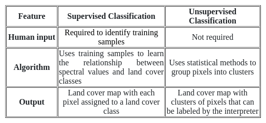
Answer: 1) Supervised classification involves human input to identify training samples, while unsupervised classification uses algorithms to group pixels based on similarity. 

Key Points Supervised and Unsupervised classification:

  • Supervised classification involves human input to identify training samples.
  • unsupervised classification uses algorithms to group pixels based on similarity.
  • In supervised classification, the interpreter selects a number of training samples that represent the different land cover classes of interest.
  • The training samples are then used to train a classifier, which is an algorithm that can assign each pixel in the image to a land cover class.
  • In unsupervised classification, the interpreter does not select any training samples. Instead, the algorithm uses statistical methods to group pixels into clusters based on their similarity.
  • The clusters can then be labeled with land cover class names by the interpreter.

Additional Information Comparison between Supervised and Unsupervised classification:

MH SET Paper 2 Mock Test - 5 (Geography) - Question 18
The main difference between the Heartland and Rimland theories lies in:
Detailed Solution for MH SET Paper 2 Mock Test - 5 (Geography) - Question 18

Answer: Option 1) Their emphasis on land versus sea power.

The Heartland and Rimland theories are two significant geopolitical concepts that have influenced international relations and strategic planning. Proposed by different scholars in the early to mid-20th century, these theories offer distinct perspectives on how geographical advantages could lead to global dominance. Understanding the core difference between them is crucial for grasping the historical and contemporary geopolitical landscape.
Key Points
Correct Option: Their emphasis on land versus sea power:
  • The Heartland Theory, proposed by Halford Mackinder, emphasizes the central importance of land power.
  • It argues that the nation that controls the central Eurasian plains (the "Heartland") could potentially achieve global domination, based on the premise that this area is strategically invulnerable and pivotal for controlling the World-Island (Eurasia and Africa).
  • The Rimland Theory, introduced by Nicholas Spykman, counters this by highlighting the significance of sea power.
  • It suggests that controlling the coastal areas or the "Rimland" that surrounds Eurasia is key to global supremacy.
  • Spykman believed that maritime mobility and control over these coastal states offered superior strategic advantages over the inland-centric approach of the Heartland Theory.
Additional Information
Their assessment of the importance of central location:
While both theories indeed consider geography's impact on power dynamics, they do not fundamentally differ in their assessment of the importance of a central location. Instead, they differ in what they consider the key area for control (central Eurasia vs. coastal regions).
Their predictions about the future of global power dynamics:
Both theories make predictions about the mechanisms of achieving global dominance but do not fundamentally differ in this aspect. The core difference is in the strategic emphasis (land power vs. sea power), not in the nature of their predictions per se.
Their origin and historical context:
Although both theories were proposed in different periods and contexts (Mackinder's Heartland Theory in the early 20th century and Spykman's Rimland Theory a few decades later), the fundamental difference between them is not derived from their origin or historical context. Instead, it's their strategic focus that distinguishes them.
Hence, option 1 is correct.
MH SET Paper 2 Mock Test - 5 (Geography) - Question 19
According to the Heartland Theory, who could potentially achieve global domination?
Detailed Solution for MH SET Paper 2 Mock Test - 5 (Geography) - Question 19

Answer: Option 4) The nation that controls the central Eurasian plains ("Heartland").

Key Points
  • The Heartland Theory was proposed by Halford Mackinder in the early 20th century. It suggests that the geographic area he called the "Heartland," essentially the central Eurasian plains, holds the key to global domination.
  • According to the theory, this region is virtually impregnable due to its lack of navigable rivers accessible from the sea and its vast distances from the coastline, making it difficult for sea powers to exert influence.
  • Mackinder summarized this concept with the phrase, "Who rules East Europe commands the Heartland; who rules the Heartland commands the World-Island; who rules the World-Island commands the world.”
  • The Heartland Theory is part of classical geopolitics and has influenced both political thought and policy in the 20th century.
  • It has been subject to criticism and revision, especially in light of contemporary global dynamics, technological advancements, and changes in international relations.
  • However, its emphasis on geography as a determinant of power remains a noteworthy aspect of geopolitical analysis.
Additional Information
Option 1) Any nation bordering the Eurasian steppes: While nations bordering the Eurasian steppes are indeed significant in terms of strategic location, the Heartland Theory specifically highlights the importance of controlling the central part of this vast area, rather than just bordering it. The theory posits that mere proximity to the Heartland does not equate to control over it or the power to achieve global domination.
Option 2) Any nation controlling the "Rimland" regions: The "Rimland" concept was introduced by Nicholas Spykman as a counterpoint to the Heartland Theory. The Rimland refers to the coastal areas that surround the Eurasian continent. While Spykman argued that controlling the Rimland was key to global power (making it an important concept in geopolitical strategy), this does not align with the Heartland Theory's focus on the central Eurasian plains as the primary source of potential global domination.
Option 3) Any nation with a large population and military force: While a large population and a strong military are significant factors in a nation's capacity to project power and influence globally, the Heartland Theory does not focus on these attributes. Instead, it emphasizes geographic location and control over the central Eurasian plains as the critical factor for achieving global domination, independent of a nation's population size or military strength.
Hence, Option 4) The nation that controls the central Eurasian plains ("Heartland") is correct.
MH SET Paper 2 Mock Test - 5 (Geography) - Question 20
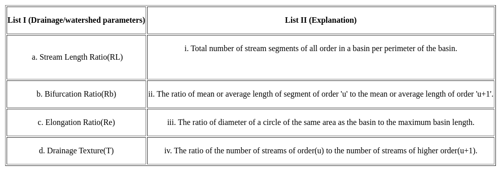
Match List I with List II:-
Detailed Solution for MH SET Paper 2 Mock Test - 5 (Geography) - Question 20

Stream length ratio= Rl= Lu/Lu+i, where, Lu is the mean length of the streams or basins of order u; the suffix u+1 denotes the same for the next higher order.

Bifurcation Ratio, Rb= Nu/Nu+i, where Nu is the number of the streams or basin of order u; the suffix u+1 denotes the same for the next higher order.

Elongation ratio(Re)= P/π L

Where, P= basin perimeter, L is maximum basin length.

Drainage Texture may be defined as the total number of streams segments of all order in a basin per perimeter of the basin.

Thus, the Correct answer is d.

MH SET Paper 2 Mock Test - 5 (Geography) - Question 21
Read the following statements given below:

(a) Monsoon break is the phenomenon which means monsoon rainfall stops for a couple of days.

(b) Western Ghats receive orographic rain during the  monsoon.

(c) First rain in a place is called as monsoon burst.

(d) The El Nino current decreases the temperature of water.

Select the correct option:

Detailed Solution for MH SET Paper 2 Mock Test - 5 (Geography) - Question 21

Western Ghats lie near the western coast of India. They occur as a hindrance for the winds of South-west monsoon winds and lead to orographic rain in the area. First occurrence of rain in an area is called as monsoon burst. During the Monsoon season, there are periods when there are sharp decrease in rainfall over most parts of the country, this is called monsoon break. The El Nino is a warm current and hence it leads to increase in temperatures by 3-4 degree Celsius.

MH SET Paper 2 Mock Test - 5 (Geography) - Question 22

Variable Y regresses with variable X with the conditions that  and b = 2.50 in the linear regression model (Y = a + bX), where are means of the respective variables and b refers to gradient of line of Y w. r. t X. Which one of the following values of parameter 'a' of the model is correct?

Detailed Solution for MH SET Paper 2 Mock Test - 5 (Geography) - Question 22

The correct answer is
Key Points

,

b = 2.50

(Y = a + bX)

Putting the values in the equation,

4.50 = a + (2.50*6.50)

or, 4.50 = a + 16.25

or, a = 4.50-16.25

or, a=-11.75

Hence, the value of 'a' of the model is -11.75.
Additional Information

Linear regression analysis:

  • Linear regression analysis is used to predict the value of a variable based on the value of another variable.
  • The variable you want to predict is called the dependent variable.
  • The variable you are using to predict the other variable's value is called the independent variable.
  • This form of analysis estimates the coefficients of the linear equation, involving one or more independent variables that best predict the value of the dependent variable.
  • Linear regression fits a straight line or surface that minimizes the discrepancies between predicted and actual output values.
  • There are simple linear regression calculators that use a “least squares” method to discover the best-fit line for a set of paired data.
  • You then estimate the value of X (dependent variable) from Y (independent variable).
MH SET Paper 2 Mock Test - 5 (Geography) - Question 23
Consider the following statements about the achievements of the Five-Year Plans-

a) balanced regional development

b) Eradication of poverty

c) Increasing trend in life expectancy

d) Technological development

Choose the correct option:-

Detailed Solution for MH SET Paper 2 Mock Test - 5 (Geography) - Question 23

The five-year plans were not able to achieve numerous fixed targets, but there has been constructive and socio-economic development. The failures were that the plans did not achieve any kind of balanced regional development. The eradication of poverty was also not achieved. Even during the year 2011-12, 21.9% of population of India was below the poverty Line.

MH SET Paper 2 Mock Test - 5 (Geography) - Question 24
Consider the following statements about Dualism:

i. Dualism means difference in views.

ii. Dualism lies in methodology.

iii. It includes content of study, approach of study and method of study.

Choose the correct option from below:

Detailed Solution for MH SET Paper 2 Mock Test - 5 (Geography) - Question 24

Dualism means difference in views, in geography dualism lies in its methodology which includes content of study, approach of study and method of study. Content is the subject matter, approach is the point of view to look at a problem, method is the way to deal with the problem.

MH SET Paper 2 Mock Test - 5 (Geography) - Question 25

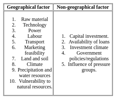
Which one of the following is not a geographical factor favorable for the location of an industry?

Detailed Solution for MH SET Paper 2 Mock Test - 5 (Geography) - Question 25

The correct answer is Capital Investment.

Key Points

  • Industrial locations are complex in nature. These are influenced by the availability of many factors.  All the factors can be broadly categorized in two,

Additional Information

  1. Geographical factors: the geographical factors are related to the earth's surface features. Such as the arrangement of physical features, climate, soil, vegetation, locational features.
  2. Non-locational features: these features are not directly dependent on the geography of the area. It is something related to the partial factors but really important for the establishment of an industry. For example, capital, govt. policies, etc.

Hence, option 1 is the correct answer.

Important Point

Capital investment:

  • Capital or investment is the basic requirement for the establishment of a manufacturing unit.
  • The amount of financial investment discerns the magnitude or scale of the unit.
  • In the modern manufacturing world, not only the product but its marketing also need tremendous capital investment.
  • The role of financial institutions like banks and insurance is increasing day by day.
  • The huge money requirement needs capital accumulation from financial agencies, state governments, and even from people is a regular practice.
MH SET Paper 2 Mock Test - 5 (Geography) - Question 26
The theory of rimland was published in which of the following book?
Detailed Solution for MH SET Paper 2 Mock Test - 5 (Geography) - Question 26

Correct Answer: The Geography of Peace

Key Points

  • In 1944, Nichols Spykman created a theory that countered Mackinder's Heartland theory. Spykman stated that Eurasia's Rimland, the coastal areas, is the key to controlling the World Island .
  • In 1944, Spykman as the point of critic or antithetic to the Heartland Theory presented his work titled “The Rimland Theory” in his book – “The Geography of Peace”
  • The rimland contains the Heartland. Whoever would control the rimland, would eventually control the World Island. Whoever would control the World Island would soon control the world.
  • His theory has been based on the 2 basic postulates of Mackinder’s Geographical Causation of History and, The conflict between Land Power and Sea power
  • His theory was influential mainly during the Cold War. The Soviet Union desired to control the rimland around them. If accomplished, the Soviet Union would control the heartland, rimland, and the World Island. 

Additional Information 

  • In 1904, Sir Halford Mackinder published the Heartland theory. The theory proposed that whoever controls Eastern Europe controls the Heartland. It also supported the concept of world dominance.
  • A more revised version explains that whoever controls the heartland, controls the world island. Whoever controls the World Island, will soon rule the world. In other words, the group or nation that dominates Hartland can then extend its domination over a far wider area. The heartland has primarily been Central Asia, the high seas, and Eurasia.
  • The Nazi party was in favor of the concept during World War II. The idea was very popular with the party, and they sought to achieve it. Also, the theory was accepted by the Soviet Union during the Cold War. Each nation made great territorial strides toward the heartland, but to no avail.
MH SET Paper 2 Mock Test - 5 (Geography) - Question 27
Given below are two statements. One is labelled as Assertion (A) and the other is labelled as Reason (R).

Assertion (A): The double-humped camel found in cold desert of Ladakh is called as Bactrian camel.

Reason (R) : Greeks called the area of central Asia as Bactria.

Select the correct answer from options given below:

Detailed Solution for MH SET Paper 2 Mock Test - 5 (Geography) - Question 27

The ancient Greeks believed that all area above the Caspian Sea is a cold desert. The ancient region of the parts of Central Asia was called as Bactria. The area extends from north of Hindu Kush mountains near Tibet to south of river Amo. The double-humped camel found in the Nubra valley is found in this region. Therefore, the camel is also called as Bactrian camel.

Thus, the correct answer is A.

MH SET Paper 2 Mock Test - 5 (Geography) - Question 28
Which of the following is suitable tern for the combination of geopolitical and strategic factors characterizing a particular geographic region?
Detailed Solution for MH SET Paper 2 Mock Test - 5 (Geography) - Question 28

Correct Answer: Geostrategy

Saul Bernard Cohen was an American human geographer. Cohen graduated from Harvard University just before the faculty closed its Department of Geography. He was President Emeritus of the Queens College and was Professor of Geography at the Hunter College in New York.

Key Points

  • Geostrategy is the geographic direction of a state's foreign policy.
  • More precisely, geostrategy describes where a state concentrates its efforts by projecting military power and directing diplomatic activity.
  • A functionally interrelated part of the Earth's surface combines a number of countries.
  • US political geographer Saul B. Cohen identified two such regions in 1973 a 'trade-dependent maritime world' (surrounding the oceans) and a Eurasian continental world centered on the USSR and China. ​
  • Soul Cohen wrote geography and politics in a World Divided.
  • Cohen divides the world into two geostrategic regions viz, trade-dependent maritime region, which is interior in directions along with 10 geopolitical regions.

Additional Information 

  • Rudolf Kjellén was a Swedish political scientist and student of Friedrich Ratzel. He first coined the term "geopolitics." His writings would play a decisive role in influencing General Karl Haushofer's geopolitik, and indirectly the future Nazi foreign policy and its use spread throughout Europe in the period between World Wars I and II (1918–39) and came into worldwide use during the latter.
  • While geopolitics is ostensibly neutral examining the geographic and political features of different regions, especially the impact of geography on politics geostrategy involves comprehensive planning, assigning means for achieving national goals, or securing assets of military or political significance.
MH SET Paper 2 Mock Test - 5 (Geography) - Question 29

Choose the correct option for the statements gien below:

(A) Endogenic forces sometimes produce sudden movements

(B) Sudden moments like earthquakes and volcanoes cause mass destruction on the surface of the earth

Detailed Solution for MH SET Paper 2 Mock Test - 5 (Geography) - Question 29

The correct answer is Both (A) and (B) are correct and (B) is the correct explanation of (A).

Key PointsThe question is related to endogenic forces and their impact on the earth's surface.

  • Option 1 is the correct answer, which states that both statements are correct, and (B) is the correct explanation of (A).
  • The following points support this answer: - Endogenic forces such as tectonic plate movements and volcanic eruptions can cause sudden movements, which can result in earthquakes and volcanic eruptions.
  • These sudden movements can cause mass destruction on the earth's surface, as stated in statement (B). - Statement (B) explains the impact of sudden movements caused by endogenic forces, which makes it the correct explanation of statement (A).
  • Option 2 is incorrect as it states that both statements are correct, but (B) is not the correct explanation of (A), which is not true, as explained above.
  • Option 3 is incorrect as it states that (A) is correct and (B) is incorrect, which is not true as a statement (B) is also correct.
  • Option 4 is incorrect as it states that (A) is incorrect and (B) is correct, which is not true as a statement (A) is also correct.

Additional Information

  • Endogenic forces are the internal forces of the earth that originate from within the earth's surface.
  • Exogenic forces are the external forces of the earth that originate from outside the earth's surface, such as wind, water, and ice.
  • The impact of endogenic forces can be seen in the form of earthquakes, volcanic eruptions, and mountain formations.
  • The impact of exogenic forces can be seen in the form of erosion, weathering, and deposition.
MH SET Paper 2 Mock Test - 5 (Geography) - Question 30
Read the following statements and select the correct answer from the code given below.

(a) Ratzel applied organic theory to biogeography.

(b) Humboldt was of the opinion that life of people living in islands, plains and mountains was similar.

(c) Kant described the impact of environment in late 18th century.

(d) Darwin’s theory of origin of species is dependent on the idea that the nature changes with time.

Code:

Detailed Solution for MH SET Paper 2 Mock Test - 5 (Geography) - Question 30

Ratzel developed the concept of Lebensraum (living space). In that he applied the concepts of organic theory to Political Geography. Humboldt travelled extensively through the world and noted that the mode of life was different in different places, such as coastal plains differed from islands, river basins or mountainous regions. Immanuel Kant, in 18th century concluded from his research that environment had a huge impact on human lifestyle. Charles Darwin, in his book Origin of species claimed that things in nature change with time.

Thus, the correct answer is D.

View more questions
Information about MH SET Paper 2 Mock Test - 5 (Geography) Page
In this test you can find the Exam questions for MH SET Paper 2 Mock Test - 5 (Geography) solved & explained in the simplest way possible. Besides giving Questions and answers for MH SET Paper 2 Mock Test - 5 (Geography), EduRev gives you an ample number of Online tests for practice

Top Courses for MAHA TET

Download as PDF

Top Courses for MAHA TET