MAHA TET Exam  >  MAHA TET Tests  >  MH SET Paper 2 Mock Test - 6 (Geography) - MAHA TET MCQ

MH SET Paper 2 Mock Test - 6 (Geography) - MAHA TET MCQ


Test Description

30 Questions MCQ Test - MH SET Paper 2 Mock Test - 6 (Geography)

MH SET Paper 2 Mock Test - 6 (Geography) for MAHA TET 2024 is part of MAHA TET preparation. The MH SET Paper 2 Mock Test - 6 (Geography) questions and answers have been prepared according to the MAHA TET exam syllabus.The MH SET Paper 2 Mock Test - 6 (Geography) MCQs are made for MAHA TET 2024 Exam. Find important definitions, questions, notes, meanings, examples, exercises, MCQs and online tests for MH SET Paper 2 Mock Test - 6 (Geography) below.
Solutions of MH SET Paper 2 Mock Test - 6 (Geography) questions in English are available as part of our course for MAHA TET & MH SET Paper 2 Mock Test - 6 (Geography) solutions in Hindi for MAHA TET course. Download more important topics, notes, lectures and mock test series for MAHA TET Exam by signing up for free. Attempt MH SET Paper 2 Mock Test - 6 (Geography) | 100 questions in 120 minutes | Mock test for MAHA TET preparation | Free important questions MCQ to study for MAHA TET Exam | Download free PDF with solutions
MH SET Paper 2 Mock Test - 6 (Geography) - Question 1

In the ancient period the boundaries developed as the

Detailed Solution for MH SET Paper 2 Mock Test - 6 (Geography) - Question 1

The correct answer is Frontier.
Key Points Frontiers: International frontiers and boundaries separate land, rivers and lakes subject to different sovereignties. In 1900 frontiers had almost disappeared and had been replaced by boundaries that are lines. A Frontier is a politico geographical area, lying beyond defined borders of a political unit into which expansion could take place.

  • Political frontiers tend to be artificial in the sense that they represent expressions of territoriality on the part of sovereign states as they define their boundaries.
  • They are zones of varying width that refer either to the political division between two countries (or political groups) or to the settled and uninhabited parts of a country.
  • As such, they are part of political geography. Such political boundaries come about for several reasons, but usually we think of them as one of five types: pioneer, antecedent, subsequent, superimposed, and relic.
  • In the ancient period the boundaries developed as the frontiers.

Additional InformationBoundaries: A boundary is a line demarcating the recognised limit of an established political unit, administrative region or geographical region e. g a state, country or district.

  • Boundaries can be classified according to their relationship with the cultural landscape.
  • Some boundaries were established prior to the permanent occupation of areas by the present inhabitants.
  • In some cases patterns of settlement were already developing so that the boundary ultimately established has a different relationship to the cultural realities of the area involved. This classification is known as the functional or genetic classification of boundaries.
MH SET Paper 2 Mock Test - 6 (Geography) - Question 2

Consider the following statements regarding the transport sector:

1. The value of the material is significantly enhanced by transportation.

2. In selecting the mode of transport, distance, in terms of time or cost, is the determining factor.

3. Isochrone lines are drawn on a map to join places equal in terms of the time taken to reach them.

Which of the above statements is/are not correct?

Detailed Solution for MH SET Paper 2 Mock Test - 6 (Geography) - Question 2

Transport

  • Transport is a service or facility by which people, materials and manufactured goods are physically carried from one location to another.
  • It is an organised industry created to satisfy man’s basic need of mobility.
  • Modern society requires speedy and efficient transport systems to assist in the production, distribution and consumption of goods.
  • At every stage in this complex system, the value of the material is significantly enhanced by transportation.
  • Transport distance can be measured as:
    • km distance or actual distance of route length
    • time distance or the time taken to travel on a particular route and
    • cost distance or the expense of travelling on a route.
  • In selecting the mode of transport, distance, in terms of time or cost, is the determining factor.
  • Isochrone lines are drawn on a map to join places equal in terms of the time taken to reach them.
1 Crore+ students have signed up on EduRev. Have you? Download the App
MH SET Paper 2 Mock Test - 6 (Geography) - Question 3

The Pygmy tribe is associated with :

Detailed Solution for MH SET Paper 2 Mock Test - 6 (Geography) - Question 3

The correct answer is Congo Basin.

Key Points

  • Pygmy People are associated with the Congo Basin of South Africa.
  • They are forager and hunter-gatherers.
  • They are divided into three groups-
    • The western Bambenga
    • The eastern Bembuti
    • The central and southern Batwa
  • They are characterized by their short stature which is described as pygmyism in anthropological literature.

Important Points

  • Major tribes of world are as follows
MH SET Paper 2 Mock Test - 6 (Geography) - Question 4
The concept largely developed by the Berkeley School of Thought, led by Carl o Sauer about the humanized geographical content of the region/ space is 
Detailed Solution for MH SET Paper 2 Mock Test - 6 (Geography) - Question 4

The correct answer is ​Cultural landscape.

Key Points

  • Cultural landscape studies, as geographer Carl Sauer and the ‘Berkeley School’ developed them from the 1940s on, focused on the evolution of places and included the ‘combination of natural and man-made elements that comprises, at any given time, the essential character of a place (see Landscape Architecture).
  • Cultural landscape studies emphasized the connection between natural environments and built interventions.
  • Cultural landscape methods are used to study the places, and people's shaping of them.
  • This method tends to stress the physical and not the political dimensions of places.
  • It helps in learning the rural, pre-industrial landscapes, vernacular house types, and patterns of cultivation, considering ecology but avoiding issues of political contestation.
  • The study of cultural landscape serves some very significant complementary purposes, which include the systematic description of the landforms, classification of types of culture on a regional basis, elaboration on the relationship enjoyed between nature and human beings in general and human settlements in particular, role of Human agency in alteration and modification of landscape particularly the natural landscape, inquiry into dynamics of social and cultural groups in the space. 
  • The concept of cultural landscape further elaborated and worked upon by Berkley Professor Carl O Sauer, played important role in strengthening and fueling the idea that Geography could justify itself by making landscape study its sole subject matter. 

Additional Information

  • The Berkeley School, Sauer's most famous work to come out of his time at U.C. Berkeley was his paper, "The Morphology of Landscape" in 1925.
  • Like much of his other work, it challenged environmental determinism and made clear his stance that geography should be the study of how present landscapes were shaped over time by people and natural processes.
  • Sauer organized the international conference, "Man's Role in Changing the Face of the Earth," at Princeton, New Jersey in 1955 and contributed to a book of the same title.
  • In it, he explained the ways humans have impacted the Earth's landscape, organisms, water, and atmosphere.
MH SET Paper 2 Mock Test - 6 (Geography) - Question 5

Given below are two statements. One is labelled as Assertion (A) and the other is labelled as Reason (R).

Assertion (A): India is the second largest irrigated country in the world.

Reason (R): The whole country of India is fully irrigated.

Select the correct answer from options given below:

Detailed Solution for MH SET Paper 2 Mock Test - 6 (Geography) - Question 5

India is the second largest irrigated country in the world. But only one-third of the total area of the country is irrigated. Majority of the country is still dependent upon the rains for water for agriculture. The Indian monsoon is highly erratic and unpredictable. Therefore, it is necessary to develop irrigation in India. Thus, (A) is true and (R) is false.

MH SET Paper 2 Mock Test - 6 (Geography) - Question 6
The Photograph that is obtained if the camera's optical axis deviates more than a few degree than vertical and the horizon is visible is known as
Detailed Solution for MH SET Paper 2 Mock Test - 6 (Geography) - Question 6

The photograph that is taken with the optical axis deliberately tilted to show the earth’s horizon is known as high oblique aerial photograph. These aerial photographs cover a large part of the earth’s surface and are used for pictorial and illustrative purposes and are used in several reconnaissance surveys.

Thus, the Correct answer is C.

MH SET Paper 2 Mock Test - 6 (Geography) - Question 7

Identify the option that arranges the following states' literacy rates in descending order, according to Census 2011.

A. Kerala

B. Himachal Pradesh

C. Haryana

Detailed Solution for MH SET Paper 2 Mock Test - 6 (Geography) - Question 7
The correct answer is (A), (B), (C).
Key Points
  • According to Census 2011, the literacy rates of the states in descending order are Kerala, Himachal Pradesh, and Haryana.
  • Kerala has the highest literacy rate of 94% among all the states in India.
  • Haryana has a literacy rate of 75.6%.
  • Himachal Pradesh has a literacy rate of 82.80%.

Additional Information

  • The Indian Census is the largest single source of a variety of statistical information on different characteristics of the people of India.
  • The first census of India was conducted by Lord Mayo in 1872.
  • The first official census was started by Lord Ripon in 1881.
  • In 2011 it is 15 census of India.
  • It comes to the Ministry of Home Affairs From 1961.
  • The slogan of the 2011 Census is Our Census Our Future.
  • C M Chandramauli was the Registrar General and Census Commissioner of India for the 2011 Indian Census.
MH SET Paper 2 Mock Test - 6 (Geography) - Question 8
Consider the following statements about human environment interaction and state which amongst the following is true:

i. The type of society has strong influence over the environment .

ii. Human characteristics have impact on the environment.

iii. Education is a key factor on people’s view of life.

iv. Ecosystem services are important for human well-being.

Choose the correct option from below:

Detailed Solution for MH SET Paper 2 Mock Test - 6 (Geography) - Question 8

 Human environment interaction involves understanding of human characteristics. The type of society strongly influences people’s attitude towards nature, their behavior, and therefore their impact on ecosystem. Important characteristics of human social systems are population size, social organization, values, technologies etc.

Thus, the Correct answer is D.

MH SET Paper 2 Mock Test - 6 (Geography) - Question 9
Which period in demographic history of India is known as the 'demographic divide'?
Detailed Solution for MH SET Paper 2 Mock Test - 6 (Geography) - Question 9

The period of stagnant population or the year of 1921 is referred to as the demographic divide. During most of the 19th century India witnessed a slow growth of population which continued till the year 1921. The population was more or less stagnant, and the high birth rate was counterbalanced by high death rate. Large scale abnormal deaths were present in this period. The census year of 1921 witnessed only a negative growth rate of -0.31% which was observed only once in India.

MH SET Paper 2 Mock Test - 6 (Geography) - Question 10
Which of the following philosophies emphasis on the thought that our thoughts determine our actions, and our actions determine the nature of the world's last?
Detailed Solution for MH SET Paper 2 Mock Test - 6 (Geography) - Question 10

Correct Answer: Cultural or social determinism.

Key Points

Cultural or social determinism:

  • Cultural or social determinism emphasizes the human element: “Our thoughts determine our acts, and our acts determine the previous nature of the world” (James, 1932).
  • As we know, human interests, desires, preju­dices, and group values vary across space.
  • The modification of an environment largely depends on our perceptions, ideas, and decision-making processes.
  • This philosophy, as advocated by American scholars, can be summed up as the principle according to which the “significance to the man of the physical and biotic features of his habitat is a function of the attitudes; objectives and technical skills of the man himself”.
  • For example, a country that is richly endowed from the point of view of the hunters might appear poor to an agricultural people; the importance of coal is not identical for those who can and cannot make use of it. 
  • The assessment of a mountain pass, for example, will differ from horses, automobiles, or airplanes; the assessment of soil fertility will not be identified from the point of view of a Japanese farmer, on the one hand, or an Amazonian Indian, on the other.
  • Similar natural conditions may call forth different reactions on the part of man and within similar sets of conditions, different cultures can take place.

Additional Information

  • social determinism is the concept that social interactions and constructs determine human behavior. Social determinism ignores non-social factors, such as biology or the physical environment, citing social aspects as being the leading influence behind the behavior.
  • The theory or doctrine is that individual behaviors are determined by societal events and other interpersonal experiences.
MH SET Paper 2 Mock Test - 6 (Geography) - Question 11

Consider the following statements:

1. Population composition refers to the structure of the population.

2. India has a triangular population pyramid.

Which of the statements given above is/are correct?

Detailed Solution for MH SET Paper 2 Mock Test - 6 (Geography) - Question 11

The correct answer is ​Both 1 and 2.

Key Points

  • Population composition refers to the structure of the population. Hence, statement 1 is correct.
  • The composition of the population helps us to know how many are males or females, which age group they belong to, how educated they are and what type of occupations they are employed in, what their income levels and health conditions are.
  • The shape of the population pyramid tells the story of the people living in that particular country.
  • The population pyramid also tells us how many dependents there are in a country.
    • There are two groups of dependents — young dependents (aged below 15 years) and elderly dependents (aged over 65 years).
    • Those of the working-age are economically active.
  • In countries where death rates (especially amongst the very young) are decreasing, the pyramid is broad in the younger age groups, because more infants survive to adulthood.
    • This can be seen in the pyramid for India. India, therefore, has a triangular population pyramid. Hence, statement 2 is correct.
    • Such populations contain a relatively large number of young people and which means a strong and expanding labour force

MH SET Paper 2 Mock Test - 6 (Geography) - Question 12
In India, rigid and stable elevated lands, denuded rocks and series of scarps are the features of which of the following?
Detailed Solution for MH SET Paper 2 Mock Test - 6 (Geography) - Question 12

The correct answer is the Peninsular plateau.

Key Points

  • Peninsular plateau
    • The land of India is characterized by great diversity in its physical features.
    • The north has a vast expanse of rugged topography consisting of a series of mountain ranges with varied peaks, beautiful valleys, and deep gorges.
    • The south consists of stable tableland with highly dissected plateaus, denuded rocks, and developed series of scarps. In between these two lies the vast north Indian plain. Hence, Option 2 is correct.
    • The Peninsular plateau is a tableland made up of crystalline, igneous, and metamorphic rocks. It was produced by the breakup and drifting of the Gondwana continent, making it the oldest landmass on the planet. Tors, block mountains, rift valleys, spurs, bare rocky formations, series of hummocky hills, and wall-like quartzite dykes are some of the region's key physiographic characteristics, which provide natural water storage sites.
    • It was developed as a result of the breakup and drifting of the Gondwana continent, making it one of the oldest landmasses.
    • The plateau has large and shallow valleys as well as rounded hills.
    • This plateau is divided into two sections: the Central Highlands and the Deccan Plateau.
    • The Central Highlands are the parts of the Peninsular plateau to the north of the Narmada river that cover a large portion of the Malwa plateau.
    • The general height of the plateau is from west to east, as seen by the direction of river flow.
    • This Peninsular plateau has seen recurring periods of uplift and submergence, which have been accompanied by crustal faulting and fractures.
    • The relief of the Peninsular plateau has become more diverse as a result of these spatial variations.

Additional Information

  • Northern mountains
    • The northern mountain complex contains the Himalayas, Trans Himalayas and Purvachal.
    • The Himalayas are in the north, Hindukush and Sulaiman are in the northwest and Purvachal in the east.
    • The Himalayas are true mountains. They are formed from the continent-continent plate collision. They have sediments of marine origin. It is not a single range but a series of ranges.
    • The Himalayas have three ranges namely the great Himalayas [Himadri], middle or lesser Himalayas [Himachal] and outer Himalayas [Shiwaliks].
  • Northern Plain
    • Youngest physiographic feature in India. Depositional flood plain created by Himalayan rivers like Indus, Ganga, Brahmaputra and Yamuna.
    • Densely populated with 30% of the world's population on 10% of the world's agricultural land.
  • Coastal plains
    • It extends from Rann of Kutch to Sunderbans.
    • It has two parts western coastal plain and the eastern coastal plain.
MH SET Paper 2 Mock Test - 6 (Geography) - Question 13

____________ predominantly acts as the agent of chemical erosion of soil.

Detailed Solution for MH SET Paper 2 Mock Test - 6 (Geography) - Question 13

Underground water predominantly acts as the agent of chemical erosion of soil.

MH SET Paper 2 Mock Test - 6 (Geography) - Question 14

Which of the following statements is correct

(1) The Oceanic crust is thinner as compared to the continental crust.

(2) Topmost layer of the Mantle is known as the Asthenosphere.

(3) The density of the outer core is higher than that of the inner core.

(4) The core is made up of heavy materials like Iron and Nickel.

Detailed Solution for MH SET Paper 2 Mock Test - 6 (Geography) - Question 14

The correct answer is 1, 2 and 4.

Key Points

  • The thickness of Oceanic crust is 5 km whereas that of Continental crust is around 30 km
  • The crust is made up of heavier rocks having a density of 3 gm/cm3
  • The asthenosphere is the uppermost portion of the Mantle which extends up to 400 km.
  • It is the main source of magma
  • The density of mantle is higher than that of crust and is equal to 3.4 gm/cm3
  • The outer core is in the liquid state while the inner core is in the solid-state
  • The density of the outer core is around 5 gm/cm3 and that of the inner core is around 13 gm/cm3
  • This layer is also known as the nife layer as it is rich in Nickel and iron.
MH SET Paper 2 Mock Test - 6 (Geography) - Question 15
Who gave a behavioral matrix for industrial location?
Detailed Solution for MH SET Paper 2 Mock Test - 6 (Geography) - Question 15

The behavioral matrix was developed by Allen Pred. He applied this matrix in a lot of different situations including industrial location. It takes into consideration decision-making process while deciding location for industry as would a common man do. It is based on ability to use the information and availability of information.

Thus, the correct answer is B.

MH SET Paper 2 Mock Test - 6 (Geography) - Question 16
Oceanic tides are the smallest on the
Detailed Solution for MH SET Paper 2 Mock Test - 6 (Geography) - Question 16
The correct answer is 8th a day of the waxing moon
Key Points
  • This is because, during this period, the Moon and Sun are at a right angle with Earth, partially canceling each other's gravitational pull on the oceans.
  • This results in less pronounced high and low tides, known as neap tides.
  • Full moon day: This is the time of the highest tides, called spring tides, due to the combined gravitational pull of the Moon and Sun aligned with Earth.
  • New moon day: Same as the full moon, neap tides do not occur on the new moon day.
  • 3rd day of the waning moon: This is not a specific timing associated with neap tides. The size of tides fluctuates throughout the lunar cycle, with neap tides occurring roughly around the first and third quarters of the moon.

Hence, we can conclude that Oceanic tides are the smallest on the 8th day of the waxing moon.

MH SET Paper 2 Mock Test - 6 (Geography) - Question 17
In July, Inter Tropical Convergence Zone (ITCZ) is located around
Detailed Solution for MH SET Paper 2 Mock Test - 6 (Geography) - Question 17

The correct answer is 20° N to 25° N latitudes.

Key Points

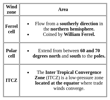
  • The Inter-Tropical Convergence Zone, or ITCZ, is the region that orbits Earth, near the equator, where the northern and southern hemisphere trade winds converge.
  • In January the ITCZ ​​is located at approximately 15°S.
  • In July it is situated at 20°N to 25°N.

Important Points

  • The Intertropical Convergence Zone (ITCZ) is a low-pressure area located on the equator.
  • Trade winds are found in this region.
  • So the air starts rising in this area.
  • I.T.C.Z in the month of July. 20° to 25°N.
  • It is situated in the Gangetic plain around the latitudes.
  • Sometimes called a monsoon trough, this monsoon trough encourages the development of thermal low air pressure over north and north-west India.
  • Due to the northward movement of ITCZ, the trade winds of the southern hemisphere cross the equator between 40° and 60° East longitude.
  • Under the influence of the Coriolis force, the direction of these trade winds crossing the equator becomes from southwest to northeast.
MH SET Paper 2 Mock Test - 6 (Geography) - Question 18
There are four domains of the natural environment. Two are the Atmosphere and Biosphere. The other two are:
Detailed Solution for MH SET Paper 2 Mock Test - 6 (Geography) - Question 18

The correct answer is Hydrosphere and Lithosphere.

Key Points

The question is about the four domains of the natural environment.

  • Option 2: Hydrosphere and Lithosphere is the correct answer.
    • Hydrosphere refers to all the water on Earth, including oceans, lakes, rivers, and groundwater.
    • The lithosphere refers to the solid part of Earth, including the crust, mantle, and core.
  • The Atmosphere refers to the layer of gases surrounding Earth, including the air we breathe.
  • The Biosphere refers to all living organisms and their interactions with the other domains.

Additional Information

  • Mesosphere is the layer of the Earth's atmosphere above the stratosphere and the thermosphere.
  • The stratosphere is the layer of the Earth's atmosphere above the troposphere and the mesosphere.
MH SET Paper 2 Mock Test - 6 (Geography) - Question 19

Given below are two statements, one is labelled as Assertion (A) and the other is labelled as Reason (R). Read the statements and choose the correct answer using the code given below.

Assertion (A) : Central Business District (CBD) of a city has high concentration of wholesale stores, offices and cultural and recreational activities.

Reason (R) : Prices and demand of real increases as distance towards CBD reduces.

Detailed Solution for MH SET Paper 2 Mock Test - 6 (Geography) - Question 19
Key Points

Assertion (A): Central Business District (CBD) of a city has a high concentration of wholesale stores, offices, and cultural and recreational activities.

The concept of CBD:

  • The term Central Business District (CBD) is a widely used term in commercial real estate and is defined as the functional area of a city that has the maximum concentration of commercial, retail, and business centers.
  • Geographically, it coincides with the city center and is the focal point for the transportation networks of the city.
  • It has maximum urban density than other districts of the town and offers a healthy environment for carrying out various commercial activities.
  • Today, CBDs are a diverse region in metro cities that not only include retail spaces, commercial, offices, financial institutions, government centres, and medical centres, but also entertainment hubs, restaurants, hotels, and residential area

Hence, the assertion is correct.

Reason (R): Prices and demand of real increases as distance towards CBD reduces.

Price and demand relationship:

  • In ancient times, CBDs were the market squares where merchants and customers gathered to sell and buy things.
  • However, as cities evolved, land scarcity and increasing demand reduced horizontal expansions and gave way to vertical developments.
  • The relationship of land price and distance to CBD is significant and negative, which means indicating the decreasing of land price by increasing distance from the CBD.
  • Market price gives the same result as the appraised price which is the effect of distance on land values is significant and negative.

Hence, the reason is also correct.

Therefore, Both (A) and (R) are true and (R) is the correct explanation of (A).

MH SET Paper 2 Mock Test - 6 (Geography) - Question 20

The first nuclear reactor of India is named

Detailed Solution for MH SET Paper 2 Mock Test - 6 (Geography) - Question 20

Apsara is the oldest of India's research reactors. The reactor was designed by the Bhabha Atomic Research Center (BARC) and built with assistance from the United Kingdom (which also provided the initial fuel supply consisting of 80 percent enriched uranium). Apsara first went critical on 4 August 1956.

MH SET Paper 2 Mock Test - 6 (Geography) - Question 21
Consider the following statements:-

a) The Geographical Pivot of History was written by Sir Halford Mackinder in the year 1904

b) According to Spykman, aerial mobility is the new type of geopolitical structure.

Which of the following options are correct?

Detailed Solution for MH SET Paper 2 Mock Test - 6 (Geography) - Question 21

Mackinder presented his model, ' The Geographical Pivot of History' in front of the Royal Geographical Society in London in 1904. This model was developed during a period when Britain was losing her political and economic significance to the world economy.

Maritime mobility, according to Spykman, was the fundamental fact that was responsible for the development of the world politics. The development of ocean navigation and sea routes to various parts of the world has led a new structure of great power and enormous extent.

MH SET Paper 2 Mock Test - 6 (Geography) - Question 22

Which of the following options is Incorrect?

Detailed Solution for MH SET Paper 2 Mock Test - 6 (Geography) - Question 22

Option 3) ​Humboldt was greatly influenced by the Darwin's theory of  ‘struggle and natural selection'.

Additional Information

  •  The first volume of Ratzel's  work Anthropogeographie was published in 1882:  The first volume of Ratzel's monumental work Anthropogeographie was published in 1882. Through his work he initiated the idea that cultural and natural phenomenon can be subjected to systematic study. In the modified second volume (1891) he discusses the significance of the historical development and cultural background of the population.
  • Ratzel wrote 'Political Geography' in which he compared 'State' to an organism:  In 1896 Ratzel wrote 'Political Geography' in which he compared 'State' to an organism. He stressed that a state, like a few simple creatures, should either grow or die or cannot stand anytime. This was the philosophy of 'living place', which created a controversy over the superior and the low levels, which advocates saying that the best people (nations) have to stay 'at the expense of neighbouring countries
  • Humboldt was greatly influenced by the Darwin's theory of  ‘struggle and natural selection':  Being contemporary of Darwin, Ratzel was influenced by the Darwin's theory of species especially the themes of ‘struggle and natural selection’ and ‘association and organisation’. It was Ratzel, who compared the mode of life of different tribes and nations, and thus made a systematic study of human geography.
  • Hettner was against environmental determinism and he appeared to be a significant contributor to the doctrine of possibilism: Hettner  a significant contributor to the doctrine of possibilism. He even rejected the idea that geography could be either idiographic or nomothetic but not both. His ideas of organization in geographical studies influenced the German geography for decade.
MH SET Paper 2 Mock Test - 6 (Geography) - Question 23

For whom it has been rightly remarked that he followed the precedent of Humboldt, attempted to revive the close connection of geography to natural sciences, and at the same time restored the Ritterian tradition and sought to fulfil the methodology of Peschel.

Detailed Solution for MH SET Paper 2 Mock Test - 6 (Geography) - Question 23

Answer: Option 3) Richthofen.

Key Points

  • Richthofen was the first German scholar, who had differentiated between 'general' and 'regional' geography.
  • He stressed that regional geography should be descriptive to highlight the key features of an area.
  • General geography, according to him, is related to the spatial distribution of personal events in the world. 
  • For systematic regional studies, he emphasized the need for regional work.
  • For regional studies, he used the term 'chorology' and differentiated it from “chorography” (non explanatory description providing information for systematic geography).

Additional Information

  •  Vidal de la Blache:

Paul Vidal de la Blache (1845-1918) was a French geographer who had a profound influence on the development of modern geography. He produced a large number of publications, including books, articles, and reports. Vidal de la Blache followed the precedent of Alexander von Humboldt, attempted to revive the close connection of geography to natural sciences, restored the Ritterian tradition, and sought to fulfill the methodology of Oscar Peschel.

  • Darwin:

Charles Darwin (1809-1882) was an English naturalist, geologist, and biologist, best known for his theory of evolution. His work had a profound influence on the development of many scientific fields, including geography. Vidal de la Blache was an admirer of Darwin's work, and he incorporated Darwinian ideas into his own geographical theories.

  • Reclus:

Élisée Reclus (1830-1905) was a French geographer and anarchist. He was a prolific writer and produced a number of influential works on geography. Vidal de la Blache and Reclus were contemporaries, and they shared many of the same ideas about geography.

MH SET Paper 2 Mock Test - 6 (Geography) - Question 24

Which of the following is NOT a theme that influenced Ratzel's work?

Detailed Solution for MH SET Paper 2 Mock Test - 6 (Geography) - Question 24

Answer: 2) Cultural Diffusion.

Friedrich Ratzel was a German geographer, ethnologist, and anthropologist who is considered to be the father of political geography. He was influenced by various themes and ideas during his lifetime, some of which had a significant impact on his work.

Key Points

  •  Among the options provided, cultural diffusion is the theme that did NOT influence Ratzel's work.
  • Cultural diffusion refers to the spread of cultural traits, such as ideas, beliefs, and practices, from one group of people to another.
  • While Ratzel was interested in the relationship between culture and geography, his primary focus was on the role of physical factors, such as climate and topography, in shaping human societies.

Additional Information 

  • The other three options, association and organization, struggle and natural selection, and historical development, were all themes that influenced Ratzel's work.
  • Ratzel believed that human societies were organized and functioned in a similar way to biological organisms, and he used Darwin's theory of evolution to explain the development of human societies.
  • He also emphasized the importance of historical factors in shaping the present-day distribution of human populations and cultures.

Therefore, the correct answer is option 2) Cultural diffusion. Ratzel's work was primarily influenced by themes such as association and organization, struggle and natural selection, and historical development, rather than cultural diffusion.

MH SET Paper 2 Mock Test - 6 (Geography) - Question 25
Which of the following option is correct regarding Penck’s Theory?
Detailed Solution for MH SET Paper 2 Mock Test - 6 (Geography) - Question 25

The German Geomorphologist, Walther Penck proposed that the geomorphic forms are an expression of the phase and rate of uplift and in relation to the rate of degradation or erosion. This explains that the interaction between upliftment and degradation are always coexistent. These are the basic premises of the Penckian model. Accordingly, Primarumpf is referred to as the formation which can be seen before the stage of upliftment. Similarly, just like the other theories, after continued upliftment and erosional factors, the landscape gets reduced to the low plain known as endrumpf. This theory contrasts with the Davisian cycle of erosion.

MH SET Paper 2 Mock Test - 6 (Geography) - Question 26
Sir Isaac Newton has improvised on the work of
Detailed Solution for MH SET Paper 2 Mock Test - 6 (Geography) - Question 26

Varenius is famous for his book Geographica Generalis. It is divided into three sections of absolute geography, comparative geography and relative geography. It is head as an important addition to the knowledge about comparative and scientific geography. Sir Isaac Newton made a lot of improvisation on the 1672 Cambridge edition of this book.

MH SET Paper 2 Mock Test - 6 (Geography) - Question 27
Which of the following is a metamorphic rock?
Detailed Solution for MH SET Paper 2 Mock Test - 6 (Geography) - Question 27

The Correct is Gneiss.

 Key Points

  • Gneiss usually forms by regional metamorphism at convergent plate boundaries.
  • It is a high-grade metamorphic rock in which mineral grains recrystallized under intense heat and pressure

 Important Points

  • Basalt is a dark-colored, fine-grained, igneous rock composed mainly of plagioclase and pyroxene minerals.
  • Syenite is an intrusive igneous rock composed of feldspar and a ferromagnesian mineral.
  • Chemically, syenites contain a moderate amount of silica, relatively large amounts of alkalies, and alumina.
  • Sandstone is a sedimentary rock composed mostly of quartz sand.
  • Sandstone that contains more than 90% quartz is called quartzose sandstone.
  • When the sandstone contains more than 25% feldspar, it is called arkose or arkosic sandstone.

Additional Information


MH SET Paper 2 Mock Test - 6 (Geography) - Question 28
Given below are two statements- one is labelled as Assertion (A) and the other is labelled as Reason (R):

Assertion (A)- Ocean currents highly affect fishing, marine organisms.

Reason(R)- Mixing of the ocean currents leads to a phenomenon that suitable for the fishes.

Choose the correct option:

Detailed Solution for MH SET Paper 2 Mock Test - 6 (Geography) - Question 28

Ocean currents are of vital importance to the marine organisms, phytoplankton’s and fishing grounds. The down welling and upwelling of water masses due to the ocean currents support the distribution of oxygen and nutrients on the ocean, hence leading to a situation suitable for the fishes. The down welling of cold-water mass take oxygen downwards and provide the growth for marine organisms and planktons. The upwelling and the convergence of warm and cold currents also promote the presence of rich nutrients. The places where cold and warm currents meet are rich in nutrients and various organisms. Hence, fishes thrive in these environments and thus form major fishing grounds. For instance, The Grand Banks off the Newfoundland is a major fishing ground due to the meeting of warm Gulf Stream and cold Labrador currents.

MH SET Paper 2 Mock Test - 6 (Geography) - Question 29

Name the currency of Japan

Detailed Solution for MH SET Paper 2 Mock Test - 6 (Geography) - Question 29

The yen is the official currency of Japan. It is the third most traded currency in the foreign exchange market after the United States dollar and the euro.

MH SET Paper 2 Mock Test - 6 (Geography) - Question 30

Match the following mining regions for which it is famous for :
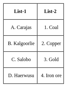

Select the correct code :
Detailed Solution for MH SET Paper 2 Mock Test - 6 (Geography) - Question 30

The correct answer is Option 4.

Key Points

The Carajas Mine

  • It is the largest iron ore mine in the world.
  • It is located in the Carajás Mountains of Northern Brazil.
  • The mine is operated as an open-pit mine and is estimated to contain roughly 7.2 billion metric tonnes of iron ore, plus gold, manganese, bauxite, copper, and nickel.
  • The mine is largely powered by hydroelectric power from the Tucuruí Dam.

Kalgoorlie mine

  • ​It is also known as the Fimiston Open Pit, colloquially known as the Super Pit, which was Australia's largest open-cut gold mine until 2016 when it was surpassed by the Newmont Boddington gold mine also in Western Australia.
  • The Super Pit is located off the Goldfields Highway on the southeast edge of Kalgoorlie, Western Australia.
  • The gold mining area of Kalgoorlie-Boulder-Fimiston has long been called the Golden Mile because of the geographical concentration of rich mines in that area.

Salobo mine

  • It is the largest copper deposit ever discovered in Brazil.
  • It is the open pit mine.
  • Salobo is an iron-oxide copper-gold (IOCG) deposit located along the southern margin of the Amazon Basin, within the Carajás Mining District, in south-eastern Para, Brazil.
  • The mineralization at the Salobo deposit is found hosted in metamorphosed rocks.

Haerwusu mine

  • With estimated recoverable coal reserves of more than 1.7 billion tonnes, the Haerwusu Coal Mine is located in the Inner Mongolia Autonomous Region of China.
  • Production from the mine was started in October 2008 and is also a major open-cast coal mine in China.
View more questions
Information about MH SET Paper 2 Mock Test - 6 (Geography) Page
In this test you can find the Exam questions for MH SET Paper 2 Mock Test - 6 (Geography) solved & explained in the simplest way possible. Besides giving Questions and answers for MH SET Paper 2 Mock Test - 6 (Geography), EduRev gives you an ample number of Online tests for practice

Top Courses for MAHA TET

Download as PDF

Top Courses for MAHA TET