Kerala SET Paper 2 Mock Test - 1 (Geography) Free Online Test 2026
Full Mock Test & Solutions: Kerala SET Paper 2 Mock Test - 1 (Geography) (120 Questions)
You can boost your KTET 2026 exam preparation with this Kerala SET Paper 2 Mock Test - 1 (Geography) (available with detailed solutions).. This mock test has been designed with the analysis of important topics, recent trends of the exam, and previous year questions of the last 3-years. All the questions have been designed to mirror the official pattern of KTET 2026 exam, helping you build speed, accuracy as per the actual exam.
Mock Test Highlights:
- - Format: Multiple Choice Questions (MCQ)
- - Duration: 120 minutes
- - Total Questions: 120
- - Analysis: Detailed Solutions & Performance Insights
Sign up on EduRev for free and get access to these mock tests, get your All India Rank, and identify your weak areas to improve your marks & rank in the actual exam.

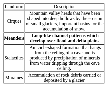
________ are loop-like channel patterns which develop over flood and delta plains.
Detailed Solution: Question 1
The theory of plate tectonics proposes that the earth’s lithosphere is divided into ______ major and some minor plates.
Detailed Solution: Question 2

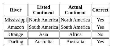
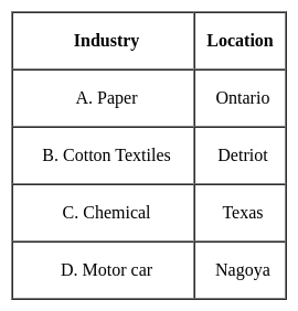
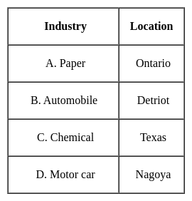
Consider the following pairs:
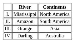
How many of the above mentioned pairs are correctly matched?
Detailed Solution: Question 3
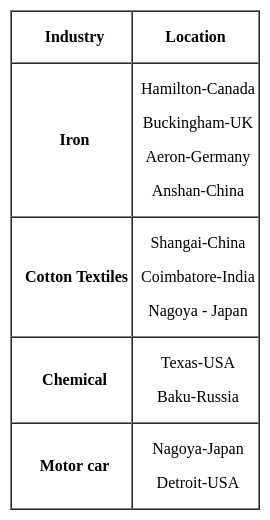
What kind of products were exported by Canada during the 19th century?
Detailed Solution: Question 4
Consider the following statements:-a. GIS is an institutional entity, reflecting an organisational structure that integrates technology with a database, expertise and continuing financial support over time.
b. GIS is an internally referenced, automated, spatial information system.
c. GIS is any manual or computer-based set of procedures used to store and manipulate geographically referenced data.
d. GIS can present the results of information analyses using multimedia technologies
Which of the following statements above is /are correct?
Detailed Solution: Question 5
Which one of the following is correct for the cost-input graph of industrial production system, where point of profit maximising output is
Detailed Solution: Question 6
Consider the following statements about human environment interaction and state which amongst the following is true:i. The type of society has strong influence over the environment .
ii. Human characteristics have impact on the environment.
iii. Education is a key factor on people’s view of life.
iv. Ecosystem services are important for human well-being.
Choose the correct option from below:
Detailed Solution: Question 7
Detailed Solution: Question 8
Arrange the following continents in descending order of size:
South America, Africa, Antarctica, Europe, North America
Choose the correct option.
Detailed Solution: Question 9
Which of these is not a type of federal state ?
Detailed Solution: Question 10
Till, Moraines and boulder clay are depositional land forms due to
Detailed Solution: Question 11
As per results from the research conducted by the Atomic Energy Commission of India, in 2011, which of the following mines is considered the largest reserve of uranium in India ?
Detailed Solution: Question 12
Given below are two statements, one is labelled as Assertion (A) and the other is labelled as Reason (R). Read the statements and choose the correct answer using the code given below.
Assertion (A) : Central Business District (CBD) of a city has high concentration of wholesale stores, offices and cultural and recreational activities.
Reason (R) : Prices and demand of real increases as distance towards CBD reduces.
Detailed Solution: Question 13
Consider the following statements about Losch’s theory of industrial location and choose which amongst them is true:i. Goods have high demand with low prices.
ii. The demand curve rotated round the production point to give shape.
iii. As the competition increases, the market areas becomes hexagonal.
Detailed Solution: Question 14
Consider the following statements:-a) The Geographical Pivot of History was written by Sir Halford Mackinder in the year 1904
b) According to Spykman, aerial mobility is the new type of geopolitical structure.
Which of the following options are correct?
Detailed Solution: Question 15
India is the leading producer of which of the following crop?
Detailed Solution: Question 16
The upper portion of the mantle is called .
Detailed Solution: Question 17
Which of the following is true about Tropical Rain forest?
(A) These forest are called evergreen forests.
(B) The trees in these forests shed their leaves at different times of the year.
(C) Sal, Teak and Shisham are important trees of these forests.
(D) These forests are called monsoon forests.
Choose the correct option
Detailed Solution: Question 18
Michel Thomas Sadler has propounded the concept of
Detailed Solution: Question 19
Which one of the following pairs is not correctly matched?
Detailed Solution: Question 20
Consider the following statements regarding the Remote Sensing Survey:
1) Information transfer is accomplished by the use of electromagnetic radiation
2) Remote Sensing from space is done by satellites
3) Remote Sensing has no application in Earthquake prediction
Which of the above statements are correct?
Detailed Solution: Question 21
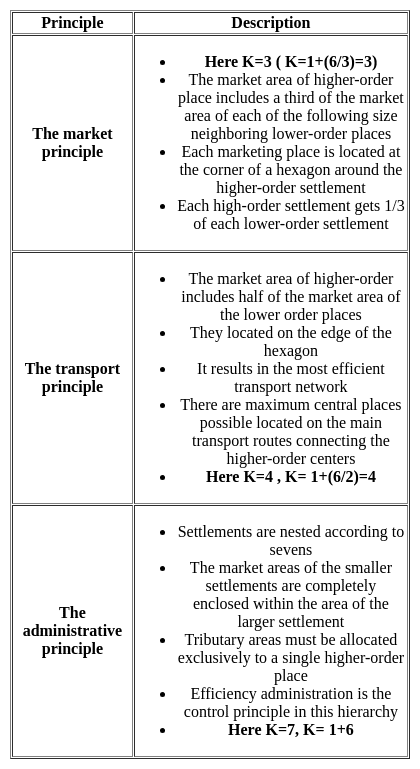
Which one of the following economic principles is correct for organisation of settlements based on K = 4 presented in the Christaller's central place model?
Detailed Solution: Question 22
A medical geographer researching the spatial distribution of asthma among children 12–17 years of age in a major U.S. city hypothesizes that there is a link between poverty and the prevalence of the disease. Which of the following research strategies would best enable the geographer to explore that hypothesis?
Detailed Solution: Question 23
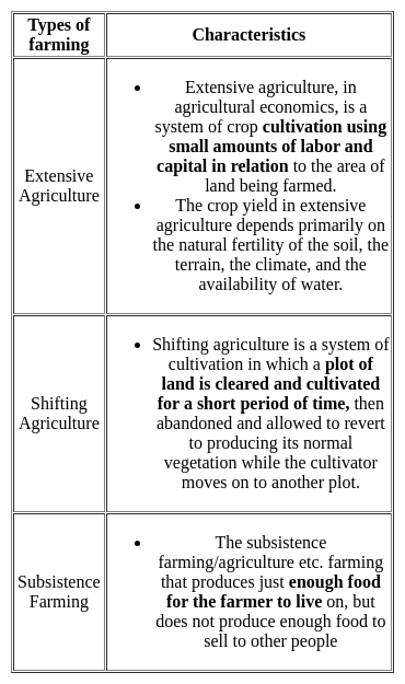
A type of farming in which higher doses of modern inputs are used to obtain higher productivity is known as
Detailed Solution: Question 24
Read the following statements and select the correct answer from the code given below:(a) The satellite towns are a part of the main city’s municipal corporation.
(b) The satellite towns develop beyond city’s green belt.
(c) The satellite towns are totally dependent upon the main city area.
(d) The satellite towns are separated from the main city physically by a geographical barrier like river.
Code:
Detailed Solution: Question 25
Detailed Solution: Question 26
Which of the human made resource have huge economic importance?
Detailed Solution: Question 27
What is the median of the values 11, 7, 6, 9, 12, 15, 19 ?
Detailed Solution: Question 28

A potential downside of medical tourism can be:
Detailed Solution: Question 29
Which one of the following is the junction point of the Eastern Ghats and Western Ghats?
Detailed Solution: Question 30