KTET Exam  >  KTET Tests  >  Kerala SET Paper 2 Mock Test - 2 (Geography) - KTET MCQ

Kerala SET Paper 2 Mock Test - 2 (Geography) - KTET MCQ


Test Description

30 Questions MCQ Test - Kerala SET Paper 2 Mock Test - 2 (Geography)

Kerala SET Paper 2 Mock Test - 2 (Geography) for KTET 2024 is part of KTET preparation. The Kerala SET Paper 2 Mock Test - 2 (Geography) questions and answers have been prepared according to the KTET exam syllabus.The Kerala SET Paper 2 Mock Test - 2 (Geography) MCQs are made for KTET 2024 Exam. Find important definitions, questions, notes, meanings, examples, exercises, MCQs and online tests for Kerala SET Paper 2 Mock Test - 2 (Geography) below.
Solutions of Kerala SET Paper 2 Mock Test - 2 (Geography) questions in English are available as part of our course for KTET & Kerala SET Paper 2 Mock Test - 2 (Geography) solutions in Hindi for KTET course. Download more important topics, notes, lectures and mock test series for KTET Exam by signing up for free. Attempt Kerala SET Paper 2 Mock Test - 2 (Geography) | 120 questions in 120 minutes | Mock test for KTET preparation | Free important questions MCQ to study for KTET Exam | Download free PDF with solutions
Kerala SET Paper 2 Mock Test - 2 (Geography) - Question 1

Who propounded the concept of 'Geographical Pivot of History'?

Detailed Solution for Kerala SET Paper 2 Mock Test - 2 (Geography) - Question 1

The correct answer is Halford J. Mackinder.

Key Points

  • In "The Geographical Pivot of History," published in 1904, Halford J. Mackinder proposed the concept of the "Geographical Pivot of History" which is often referred to as "Heartland Theory".
  • The theory argues that the key to controlling the world is to control the interior of Eurasia, known as the Heartland. 

Thus "The Geographical Pivot of History."  was propounded by Halford j. Mackinder

Additional Information The Heartland Theory is a geographical theory proposed by British geographer Halford J. Mackinder in 1904. It is also known as the "Geographical Pivot of History" theory

Mackinder postulated the following, which became known as the Heartland Theory:

  • ​Who rules Eastern Europe commands the Heartland
  • Who rules the Heartland commands the World-Island
  • Who rules the World-Island commands the world

Kerala SET Paper 2 Mock Test - 2 (Geography) - Question 2

Whose work is “the study of social geography”?

Detailed Solution for Kerala SET Paper 2 Mock Test - 2 (Geography) - Question 2

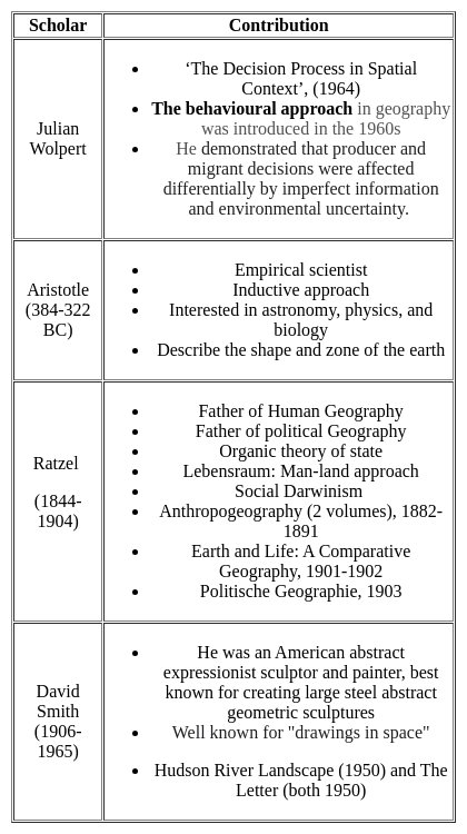
George Wilson Hoke was the first person to use the term social geography. He published his paper titled “ the study of social geography”. It was published in the year 1907

Thus, the Correct answer is A.

1 Crore+ students have signed up on EduRev. Have you? Download the App
Kerala SET Paper 2 Mock Test - 2 (Geography) - Question 3

Which of the following is NOT one of the three chief movements of ocean waters?

Detailed Solution for Kerala SET Paper 2 Mock Test - 2 (Geography) - Question 3

The correct answer is Water Current.Key Points

  • The 3 chief movements of ocean water are:
    • the waves,
    • the tides, and
    • the ocean currents.
  • Hence Water Current is NOT one of the three chief movements of ocean waters.
  • Oceans are a major part of the Hydrosphere.
  • They are all interconnected. The ocean waters are always moving.
  •  The five major oceans are the Pacific Ocean, the Atlantic Ocean, the Indian Ocean, the Southern Ocean, and the Arctic Ocean, in order of their size.

Additional Information

  • Ocean currents are the constant, predictable, directional movement of seawater driven by gravity, wind (the Coriolis effect), and the density of the water.
  • Ocean water moves in two directions: horizontally and vertically. 
  • Horizontal movements are referred to as currents, while vertical changes are referred to as upwellings or downwellings.
  • Ocean currents are one of the factors that affect the temperature of ocean water.
    • Warm ocean currents raise the temperature in cold areas.
    • Cold ocean currents decrease the temperature in warmer areas.
Kerala SET Paper 2 Mock Test - 2 (Geography) - Question 4
____________ is also called ‘’stop and go determinism’’.
Detailed Solution for Kerala SET Paper 2 Mock Test - 2 (Geography) - Question 4

The correct answer is Neo-Determinism

Key PointsNeo-determinism

  • Neo-determinism reflects a middle path between two ideas of environmental determinism and possibilism.
  • It means that possibilities can be created within the limits which do not the environment.
  • Humans can control nature by obeying them. Concept: Nature of Human Geography.
  • The concept of Neo-determinism in geography is one of three major approaches in geography (the others being determinism and possibilism) that explain human and environmental relationships.
  • As, neither environmental determinism nor possibilism has been able to explain the relationship between humans and the environment correctly, hence the concept of neo-determinism emerged in geography. 
  • Neo-determinism is also called "Stop and go determinism" because it believes that if human activities (pollution) cause long-term damage to the environment then such activities should be stopped otherwise humans can do everything that the environment allows us to do.
Kerala SET Paper 2 Mock Test - 2 (Geography) - Question 5

Consider the following statements regarding Geothermal Energy:

1. Generated due to Radioactive decay of the material inside the surface of the Earth.

2. India does not contribute in its production due to its location near the Himalayas.

Which of the statements given above is/are correct?

Detailed Solution for Kerala SET Paper 2 Mock Test - 2 (Geography) - Question 5

The correct answer is 1 only.Key PointsGeothermal Power

  • Geothermal energy is the thermal energy in the Earth's crust.
  • The high temperature and pressure in Earth's interior cause some rock to melt and solid mantle to behave plastically.
  • It originates from the:
    • Formation of the planet.
    • Radioactive decay of materials. Hence statement 1 is correct.
  • This results in parts of the mantle convecting upward since it is lighter than the surrounding rock.
  • USA has the world’s largest geothermal power plants.
  • Norway was the first country in the world to develop hydroelectricity.
  • Geothermal energy taps into the thermal energy and radioactive decay leftover from the formation of the Earth.
  • A small portion of the core’s heat comes from the friction and gravitational pull formed when Earth was created more than 4 billion years ago.
  • However, the vast majority of Earth’s heat is constantly generated by the decay of radioactive isotopes, such as potassium-40 and thorium-232.
  • Puga Valley:
    • It is situated in the Changthang Valley in the southeastern part of Ladakh
    • It is a region of great significance known for its natural beauty and geothermal activities.
    • Puga also has a hot sulphur spring. Hence statement 2 is incorrect.
  • The promising geothermal sites for direct heat use applications are:
    • Rajgir in Bihar, Manikaran in Himachal Pradesh,
    • Surajkund in Jharkhand, Tapoban in Uttarakhand & Sohana region in Haryana.
Kerala SET Paper 2 Mock Test - 2 (Geography) - Question 6
Which one of the following assumptions in Von Thunen’s model of agriculture land use is not true?
Detailed Solution for Kerala SET Paper 2 Mock Test - 2 (Geography) - Question 6

Johann Heinrich Von Thunen developed a crop theory in 1826 in which he took various assumptions like an isolated estate, isotropic surface, uniform price for a crop in the market and there would be only one market for one agricultural area where the surplus of the agricultural area will be sold.

Kerala SET Paper 2 Mock Test - 2 (Geography) - Question 7
Who conceptualized electromagnetic radiation as an electromagnetic wave that travels through space at the speed of light?
Detailed Solution for Kerala SET Paper 2 Mock Test - 2 (Geography) - Question 7

James Clerk Maxwell was the one who conceptualized the wave nature of the EMR and stated that Electromagnetic energy propagates in harmonic sinusoidal wave motion, consisting of inseparable revolving electric and magnetic fields that are always perpendicular to one another and to the direction of propagation. All EM radiation travel with the same speed in a particular medium and equal to the velocity of light in a vacuum. Hence it can be stated as c=f*(lambda). Where, c= speed of light, f =frequency, lambda= wavelength.

Kerala SET Paper 2 Mock Test - 2 (Geography) - Question 8

Consider the following pairs

How many of the above pairs is/are correctly matched?

Detailed Solution for Kerala SET Paper 2 Mock Test - 2 (Geography) - Question 8

​The correct answer is option 2.Key Points Hadley Cell:

  • ​​The cell is located between 10-30 degree latitudes in both hemispheres.
  • This is a thermally induced cell and is the result of intense solar insolation.
  • The intense insolation produces rising air along the equator.
  • The rising air cools down below the tropopause and diverges towards the pole as the anti-trade wind.
  • They lead to upper air around 30 degrees latitude and sink causing subtropical high pressure. Hence pair 1 is not correct.
  • The trade wind flows from this High Pressure toward the equator and completes this cell.

Ferrel Cell:

  • This cell extends from 35 to 60-degree latitude in both hemispheres between subtropical highs and sub-polar lows. Hence pair 2 is correct.
  • This is a thermally indirect cell and induced due to dynamic forces.
  • In this cell, the warm air is seen ascending from the polar front and breaking through near the tropopause.
  • The most important feature of this cell is that the polar front is more continuous in the middle troposphere.
  • There is a subsidence of air in the horse latitude from the tropical as well as polar front dells.
  • On the surface, the circulation is completed by the westerly wind blowing toward the poleward side.

Polar Cell:

  • It extends from 65 to 90 degrees in both hemispheres between subpolar lows and polar highsHence pair 3 is correct.
  • This is a thermally direct cell and is strongest during winter.
  • There is sinking air along the poles which moves towards the subpolar low as the easterly wind.
  • In the subpolar lows, the easterly and westerly interact and the air rise to complete the polar cell circulation.

Kerala SET Paper 2 Mock Test - 2 (Geography) - Question 9
which factor has arguably diminished the strategic importance of the "Heartland" in recent times?
Detailed Solution for Kerala SET Paper 2 Mock Test - 2 (Geography) - Question 9

Answer: Option 2) Development of long-range missiles and nuclear weapons.

The Heartland Theory, once a cornerstone of geopolitical strategy, posited that control over the central Eurasian landmass could grant a nation unparalleled power and influence. However, the evolution of military technology, particularly in the post-World War II era, has challenged the theory's relevance. Among the developments that have altered the strategic landscape, the advent of long-range missiles and nuclear weapons stands out as particularly transformative.
Key Points
Development of long-range missiles and nuclear weapons:
  • The advent of long-range missiles and the proliferation of nuclear weapons have fundamentally changed the nature of military strategy and deterrence.
  • These technologies allow states to project power and exert influence far beyond their immediate geographic regions, reducing the strategic centrality of the Heartland.
  • Physical control over landmasses, while still significant, is less critical when intercontinental ballistic missiles (ICBMs) can traverse the globe.
  • Nuclear weapons, moreover, have introduced the concept of mutual assured destruction (MAD), which makes the conventional military control of vast territories less relevant to global dominance.
Additional Information
Increased global trade and economic interdependence:
  • While increased global trade and economic interdependence have indeed reshaped international relations, making economies more interconnected and reducing the likelihood of conflict among major powers, this factor has not directly diminished the Heartland's strategic importance.
  • Instead, it has contributed to a more integrated world where geopolitical strategy also considers economic leverage and trade routes.
Growing importance of access to natural resources:
  • The growing importance of access to natural resources has, in fact, potentially increased the significance of regions rich in resources, including parts of the Heartland.
  • However, resource access is a factor that enhances rather than diminishes a region's strategic value.
  • Therefore, it does not directly lead to a decrease in the Heartland's strategic importance but rather shifts the focus within geopolitical considerations.
Rise of regional powers with independent ambitions:
  • The rise of regional powers and their independent ambitions has indeed diversified the geopolitical landscape, challenging the unipolar or bipolar models that dominated Cold War-era thinking.
  • While this development has made global politics more multipolar and complex, it does not directly diminish the Heartland's strategic importance as conceptualized by Mackinder.
  • Instead, it introduces more actors with varying interests, complicating the strategic calculus.
Important Points
  • The evolution of military technology, particularly nuclear weapons and long-range missiles, exemplifies how advancements can shift the parameters of geopolitical strategy.
  • These developments have prompted strategists to reconsider traditional notions of power and control, illustrating the dynamic nature of international relations.
  • While geography remains a critical element in geopolitics, the means by which it influences global dynamics continue to evolve, reflecting broader changes in technology, politics, and society.
Kerala SET Paper 2 Mock Test - 2 (Geography) - Question 10
Which of the following statements BEST reflects the overall view on these geostrategic theories?
Detailed Solution for Kerala SET Paper 2 Mock Test - 2 (Geography) - Question 10

Answer: option 3.

The Heartland and Rimland theories have been seminal in the study of geopolitics, offering frameworks for understanding global power dynamics through geographical lenses. While each theory has its critics and limitations, especially in the context of contemporary technological and geopolitical developments, they continue to provide foundational perspectives for analyzing international relations.
Key Points
The Heartland and Rimland theories provide valuable but contrasting insights:
  • Both theories approach the concept of global dominance from different geographical standpoints, with the Heartland Theory focusing on the central Eurasian landmass and the Rimland Theory emphasizing the strategic importance of coastal areas.
  • Despite criticisms and evolving global contexts, both theories contribute to a more nuanced understanding of the interplay between geography and power.
  • They offer contrasting yet complementary perspectives, encouraging analysts to consider a broader range of factors when assessing geostrategic dynamics.
Additional Information
Both theories are completely outdated and have no relevance in the modern world:
  • This statement dismisses the foundational insights provided by both theories into the significance of geography in global politics.
  • While technological advancements and new geopolitical challenges may have altered the landscape since these theories were first proposed, the core idea that geography matters in international relations remains relevant.
  • Moreover, elements of these theories continue to inform strategic thinking and policy-making in various contexts.
The Rimland Theory offers a more accurate perspective than the Heartland Theory:
  • Declaring one theory as more universally accurate than the other oversimplifies the complexity of geopolitics.
  • Each theory provides perspectives that are valuable in different contexts, and their relevance can vary depending on the specific geopolitical situation being analyzed.
  • It is more productive to view them as complementary rather than in competition for accuracy.
The theories are useful for historical analysis but offer limited predictive power:
  • While it's true that the predictive power of these theories may be limited, especially in light of modern technological and international developments, this statement underestimates the continuing impact of geography on geopolitical strategies and decisions.
  • These theories are not only useful for understanding past geopolitical strategies but also for framing current issues in a broader geographical context.
  • The insight that geography plays a critical role in international relations remains pertinent.

Hence, option 3.The Heartland and Rimland theories provide valuable but contrasting insights is correct.

Kerala SET Paper 2 Mock Test - 2 (Geography) - Question 11
Critics of the Heartland Theory argue that:
(i) Technological advancements have reduced the strategic value of the "Heartland".
(ii) Controlling such a vast and diverse region is logistically impossible.
(iii) The theory is outdated and irrelevant to contemporary geopolitics.
Detailed Solution for Kerala SET Paper 2 Mock Test - 2 (Geography) - Question 11

Answer; Option 3) Only (i) and (ii) are true.

The Heartland Theory, developed by Halford Mackinder in the early 20th century, has been influential in shaping geopolitical thought. It posits that the nation controlling the central Eurasian landmass could potentially dominate the globe. Despite its historical significance, the theory has faced various criticisms over the years, especially concerning technological advancements and the logistics of controlling such a vast region.

Key Points
Correct Criticisms:
Technological advancements have reduced the strategic value of the "Heartland"
  • Critics argue that with the advent of advanced technologies, especially in transportation and military capabilities (like air travel and missile technology), the geographical advantage theorized by Mackinder has diminished.
  • These advancements enable power projection over vast distances without the need for direct geographical control, thus undermining the Heartland's supposed invulnerability and strategic value.
Controlling such a vast and diverse region is logistically impossible
  • The Eurasian "Heartland" is incredibly vast, covering several countries with varied geographic, demographic, and socio-political landscapes.
  • Critics point out that effectively controlling this entire area, managing its resources, and integrating its diverse populations under a single strategic agenda is logistically unfeasible.
  • Such control would require immense resources and constant effort to maintain dominance and order, challenging the practicality of the Heartland Theory.
Additional Information
The theory is outdated and irrelevant to contemporary geopolitics:
  • While some critics argue that the Heartland Theory is outdated, saying it is entirely irrelevant might be an oversimplification.
  • Even though direct aspects of the theory may seem less applicable due to the reasons mentioned above, the importance of geography in strategic considerations still holds value.
  • Contemporary geopolitical strategies continue to be influenced by geographic factors, though in a more nuanced manner that accounts for technological, economic, and political developments.
  • Therefore, while the theory in its original form might face challenges of applicability, the fundamental idea that geography matters in international relations is still relevant.
Kerala SET Paper 2 Mock Test - 2 (Geography) - Question 12
Match List-I with List-II and select the correct answer from the codes given below :

Detailed Solution for Kerala SET Paper 2 Mock Test - 2 (Geography) - Question 12

Carbon cycle is a biogeochemical cycle where carbon is exchanged among the biosphere, geosphere, hydrosphere and atmosphere of the earth.

Riebeek published their work in 2011 titled “The carbon cycle”.

Holmes published his work in 2008 entitled “the age of wonder”

Archer published his work in 2010 named “the global carbon cycle’

Prentice in 2001 published his work called “the carbon cycle and atmospheric carbon dioxide”

Thus, the Correct answer is B.

Kerala SET Paper 2 Mock Test - 2 (Geography) - Question 13

Given below are the two statements, one labelled as Assertion (A) and the other labelled as Reason (R). Select your answer from the code given below :

Assertion (A) : According, to Lee’s migration model, metropolitan areas are centers for immigration.

Reason (R) : The metropolitan areas have pull factors.

Code :

Detailed Solution for Kerala SET Paper 2 Mock Test - 2 (Geography) - Question 13

The metropolitan areas have forces which attract people who want to migrate. These forces include better lifestyle, employment opportunities, educational facilities, etc. These forces were termed as pull factors by Lee. Thus, metropolitan areas have pull factors and have high rates of immigration. Thus, (A) and (R) are true and (R) is the correct explanation of (A).

Kerala SET Paper 2 Mock Test - 2 (Geography) - Question 14

Soil can be Conserved by:-

Detailed Solution for Kerala SET Paper 2 Mock Test - 2 (Geography) - Question 14

Soil can be Conserved by Planting of Trees. Soil conservation is the prevention of soil loss from erosion or prevention of reduced fertility caused by over usage, acidification, salinization or other chemical soil contamination. Slash-and-burn and other unsustainable methods of subsistence farming are practiced in some lesser developed areas.

Kerala SET Paper 2 Mock Test - 2 (Geography) - Question 15

Census data released on july 15,2011 reflects that 13.48 percent urban population lives in

Detailed Solution for Kerala SET Paper 2 Mock Test - 2 (Geography) - Question 15

As per census 2011, Maharashtra has 13.48% of urban population. About 70% of population of India lives in rural areas. Goa & Mizoram are 1st in terms of being urban whereas Himachal Pradesh has 90% rural population, the most in India.

Kerala SET Paper 2 Mock Test - 2 (Geography) - Question 16

In which stage of landscape evolution do relief features become more subdued?

Detailed Solution for Kerala SET Paper 2 Mock Test - 2 (Geography) - Question 16

Answer: Option 2) Mature stage.

Key Points

  • Understanding the stages of landscape evolution is essential for comprehending how landforms change over time.
  • One critical aspect of this evolution is the transformation of relief features, which become more subdued as landscapes progress through various stages.
  • Mature stage: The mature stage represents a transitional phase where relief features begin to become more subdued.
  • While some rugged terrain may still persist, the overall topography becomes gentler, with smoother slopes and less pronounced landforms.
  • Rivers widen their valleys through lateral erosion, and the landscape achieves a more balanced state between erosion and uplift.

Additional Information 

  • Youthful stage: In the youthful stage of landscape evolution, relief features are typically pronounced, characterized by steep slopes, rugged terrain, and prominent landforms such as peaks and valleys. This stage is marked by intense erosion and rapid changes in topography as geological forces sculpt the landscape with vigor.
  • Old age stage: In the old age stage, relief features are significantly subdued, and the landscape exhibits low relief with nearly level surfaces. Rivers meander across broad floodplains, and mountain ranges are reduced to residual hills and isolated remnants. This stage is characterized by extensive erosion, leading to the formation of peneplains—nearly level surfaces eroded to a uniform low elevation.
  • Transitional stage: The transitional stage represents a period of flux between different stages of landscape evolution. Relief features may exhibit characteristics of both youthful and mature stages as the landscape undergoes gradual transformation. This stage is marked by dynamic processes as the landscape adjusts to changing geological and environmental conditions.

Important Points 

  • The transformation of relief features is influenced by a variety of factors, including the type and intensity of erosion, tectonic activity, and climatic conditions.
  • Different landscapes may exhibit variations in the rate and sequence of relief feature modification, depending on their geological history and environmental context.
Kerala SET Paper 2 Mock Test - 2 (Geography) - Question 17
What is known as doldrums?
Detailed Solution for Kerala SET Paper 2 Mock Test - 2 (Geography) - Question 17

The correct answer is Equilateral low-pressure Belts.

Important Points

  • Doldrums, also called equatorial low-pressure belts are equatorial regions of light ocean currents and winds within the intertropical convergence zone (ITCZ), a belt of converging winds and rising air encircling Earth near the Equator. Hence, option 1 is the correct answer.
  • The northeast and southeast trade winds meet there; this meeting causes air uplift and often produces clusters of convective thunderstorms. They occur along the Equator in the Indian and western Pacific oceans and slightly north of the Equator off the African and Central American west coasts. The crews of sailing ships dreaded the doldrums because their ships were often becalmed there; the designation for the resultant state of depression was apparently thus extended to these geographic regions themselves.
Kerala SET Paper 2 Mock Test - 2 (Geography) - Question 18

Which of the following statement is correct related to the rocks?

1. Rocks formed out of solidification of magma and lava and are known as igneous rocks.

2. Acidic rocks does not constitute the sial portion of the crust.

Detailed Solution for Kerala SET Paper 2 Mock Test - 2 (Geography) - Question 18

The correct answer is 1 only.

Key Points

Igneous Rocks or Primary Rocks

  • The solidification of magma formed the first rocks on earth.
  • Rocks formed out of solidification of magma (molten rock below the surface) and lava (molten rock above the surface) and are known as igneous or primary rocks. Hence, Statement 1 is correct.
  • Having their origin under conditions of high temperatures the igneous rocks are unfossiliferous.
  • Granite, gabbro, and basalt are some examples of igneous rocks.
  • There are three types of igneous rocks based on the place and time taken in cooling of the molten matter, plutonic rocks, volcanic rocks and intermediate rocks.
  • There are two types of rocks based on the presence of acid-forming radicals, silicon, acidic rocks and basic rocks.

Acidic Rocks

  • Acidic rocks are characterised by a high content of silica (quartz and feldspar) — up to 80 per cent.
  • The rest is divided among aluminium, alkalis, magnesium, iron oxide, lime etc.
  • These rocks have a lesser content of heavier minerals like iron and magnesium. Hence, they are less dense and are lighter in colour than basic rocks.
  • These rocks constitute the sial portion of the crust. Hence, Statement 2 is not correct.
  • Due to the excess of silicon, acidic magma cools fast, and it does not flow and spread far away.
  • High mountains are formed of this type of rock.
  • Add rocks are hard, compact, massive and resistant to weathering.
  • Granite, quartz and feldspar are typical examples.

Additional Information

Sedimentary rocks

  • It is formed by lithification ― consolidation and compaction of sediments.
  • Hence, they are layered or stratified of varying thicknesses. Example: sandstone, shale etc.
  • Sediments are a result of denudation (weathering and erosion) of all types of rocks.
  • These types of rocks cover 75 per cent of the earth’s crust but volumetrically occupy only 5 per cent (because they are available only in the upper part of the crust).
  • Ice deposited sedimentary rocks are called till or tillite. Wind-deposited sediments are called loess.
Kerala SET Paper 2 Mock Test - 2 (Geography) - Question 19
Which of the following is a divergent or constructive plate boundary?
Detailed Solution for Kerala SET Paper 2 Mock Test - 2 (Geography) - Question 19

The Eurasian plate and North American plate are diverging or moving away from each other, forming the Mid-Atlantic range, the longest mountain range in the world. The Amid-Atlantic range is visible above sea level in Iceland and between North America and Africa.

Thus, the Correct answer is C.

Kerala SET Paper 2 Mock Test - 2 (Geography) - Question 20

Consider the following departments/ministries:

  1. Ministry of Personnel, Public Grievances and Pensions
  2. Department of Atomic Energy
  3. Department of Space

Which of the above is/are under the direct charge of the Prime Minister of India?

Detailed Solution for Kerala SET Paper 2 Mock Test - 2 (Geography) - Question 20

All the above mentioned departments/ministries are under the direct charge of the Prime Minister. 

Kerala SET Paper 2 Mock Test - 2 (Geography) - Question 21
The concept largely developed by the Berkeley School of Thought, led by Carl o Sauer about the humanized geographical content of the region/ space is 
Detailed Solution for Kerala SET Paper 2 Mock Test - 2 (Geography) - Question 21

The correct answer is ​Cultural landscape.

Key Points

  • Cultural landscape studies, as geographer Carl Sauer and the ‘Berkeley School’ developed them from the 1940s on, focused on the evolution of places and included the ‘combination of natural and man-made elements that comprises, at any given time, the essential character of a place (see Landscape Architecture).
  • Cultural landscape studies emphasized the connection between natural environments and built interventions.
  • Cultural landscape methods are used to study the places, and people's shaping of them.
  • This method tends to stress the physical and not the political dimensions of places.
  • It helps in learning the rural, pre-industrial landscapes, vernacular house types, and patterns of cultivation, considering ecology but avoiding issues of political contestation.
  • The study of cultural landscape serves some very significant complementary purposes, which include the systematic description of the landforms, classification of types of culture on a regional basis, elaboration on the relationship enjoyed between nature and human beings in general and human settlements in particular, role of Human agency in alteration and modification of landscape particularly the natural landscape, inquiry into dynamics of social and cultural groups in the space. 
  • The concept of cultural landscape further elaborated and worked upon by Berkley Professor Carl O Sauer, played important role in strengthening and fueling the idea that Geography could justify itself by making landscape study its sole subject matter. 

Additional Information

  • The Berkeley School, Sauer's most famous work to come out of his time at U.C. Berkeley was his paper, "The Morphology of Landscape" in 1925.
  • Like much of his other work, it challenged environmental determinism and made clear his stance that geography should be the study of how present landscapes were shaped over time by people and natural processes.
  • Sauer organized the international conference, "Man's Role in Changing the Face of the Earth," at Princeton, New Jersey in 1955 and contributed to a book of the same title.
  • In it, he explained the ways humans have impacted the Earth's landscape, organisms, water, and atmosphere.
Kerala SET Paper 2 Mock Test - 2 (Geography) - Question 22
Who says 'geography is the science which deals with the art of map-making'?
Detailed Solution for Kerala SET Paper 2 Mock Test - 2 (Geography) - Question 22

Key Points Contributions of Ptolemy:

  • Planetary hypothesis
  • Text on classical astronomy entitled ‘Almagest’ ( the mathematical treatise)
  • The Geography/ The Guide to Geography
  • The optics and The Tetrabiblos
  • Astrology
  • Explore the Terra-Incognita (the unknown land)
  • A detailed topographical description of places and their history called ‘chorography’
  • He said 'geography is the science which deals with the art of map-making.'

Hence, Ptolemy is the correct answer.

Additional Information

Kerala SET Paper 2 Mock Test - 2 (Geography) - Question 23
The Red Data Book which lists the endangered species is maintained by which of the following organisation?
Detailed Solution for Kerala SET Paper 2 Mock Test - 2 (Geography) - Question 23

The Red Data Book which lists the endangered species is maintained by IUCN.

Important Points

The International Union for Conservation of Nature (IUCN) maintains the Red List of Threatened Species, also known as the Red Data Book. This list is the world's most comprehensive inventory of the global conservation status of plant and animal species.

Red Data Books:

  • The "Red Data Books" published by the International Union for Conservation of Nature and Natural Resources (IUCN) is the world's most comprehensive inventory of the global conservation status of plant and animal species.
  • A red data book is beneficial for providing detailed information for studies and research. It also helps in monitoring programs on rare and endangered species. It thus helps in protecting the species that are on the verge of extinction
  • IUCN is a network of environmental organizations founded as the International Union for the Protection of Nature in October 1948 in Fontainebleau, France.
  • It promotes nature conservation and the ecologically sustainable use of natural resources.
  • It changed its name to the International Union for Conservation of Nature and Natural Resources (IUCN) in 1956.
  • IUCN is composed of both government and civil society organizations which harness the experience, and resources.
  • Headquarters: Gland, Switzerland.
  • The IUCN maintains the IUCN Red List of Threatened Species, which was established in 1964.
  • IUCN also played a fundamental role in the creation of key international conventions, including the Ramsar Convention on Wetlands (1971), the World Heritage Convention (1972), the Convention on International Trade in Endangered Species, (1974), and the Convention on Biological Diversity (1992), UNFCCC, etc.
  • Caring for the Earth was published by the three organizations in the run-up to the 1992 Earth Summit.

Additional Information

UNO: The United Nations Organization (UNO)

  • It is an intergovernmental organization that was established in 1945 after World War II to promote international peace, security, and cooperation.
  • It is composed of member states from around the world and has various specialized agencies, programs, and funds that work on a wide range of issues, including human rights, economic development, health, and the environment.

WHO: The World Health Organization (WHO)

  • It is a specialized agency of the United Nations that is concerned with international public health.
  • It was established in 1948 and is responsible for providing leadership on global health matters, shaping the health research agenda, setting norms and standards, articulating evidence-based policy options, and monitoring and assessing health trends.

WWF: The World Wildlife Fund (WWF)

  • It is an international conservation organization that works to protect the environment and endangered species.
  • It was established in 1961 and has worked to protect biodiversity, conserve natural habitats, reduce pollution and wasteful consumption, and promote sustainable development.
  • The WWF operates in over 100 countries and has been instrumental in the creation of protected areas and the conservation of endangered species, such as pandas, tigers, and elephants.
Kerala SET Paper 2 Mock Test - 2 (Geography) - Question 24

Consider the following facts about the population of Scheduled Tribes:

1. The total population of Scheduled Tribes accounts for about 8% of the total population of the country.

2. Majority of the Scheduled tribe population live in rural areas and their population is around 10% of the total rural population of the country.

3. The share of the Scheduled Tribe population in urban areas is a meager 5%.

Which of the above is/are correct?
Detailed Solution for Kerala SET Paper 2 Mock Test - 2 (Geography) - Question 24
  • The total population of Scheduled Tribes is 84,326,240 as per the Census 2011 which accounts for 8.2% of the total population of the country.
  • Majority of the Scheduled tribe population live in rural areas and their population is 10.4% of the total rural population of the country.
  • The share of the Scheduled Tribe population in urban areas is a meager 2.4%.
  • Madhya Pradesh, Maharashtra, Orissa, Gujrat, Rajasthan, Jharkhand, Chhattisgarh, Andhra Pradesh, West Bengal, and Karnataka are the states having larger number of Scheduled Tribes.
  • These states account for 83.2% of the total Scheduled Tribe population of the country.
  • Assam, Meghalaya, Nagaland, Jammu & Kashmir, Tripura, Mizoram, Bihar, Manipur, Arunachal Pradesh, and Tamil Nadu, account for another 15.3% of the total Scheduled Tribe population. The share of the remaining states / UTs is negligible.
Kerala SET Paper 2 Mock Test - 2 (Geography) - Question 25

Which country produces the most fish?

Detailed Solution for Kerala SET Paper 2 Mock Test - 2 (Geography) - Question 25

The Correct Answer is Peru

Key Points

  • Peru
    • Peru is placed 4th in our list of fish-producing countries.
    • This country produces 5,854,233 metric tons of fish annually.
    • This country has been a leading producer of fish since 1960, although fish production has declined recently due to overfishing even led to the extinction of some species.
    • Peru is blessed with a 3000 km coastline and 12,000 lakes and lagoons that hosts over 50 species of fishes.
    • The fish industry in Peru is one of the major sources of income for a majority of people.
  • Its nutrient-rich environment supports the world's largest fishery.
  • Top 5 countries of fish production:
    • China (58.8 million tonnes)
    • India (9.46 million tonnes)
    • Indonesia (6.10 million tonnes)
    • Peru (5.85 million tonnes)
    • US (5.36 million tonnes)

Additional Information

  • Aquaculture
    • Aquaculture simply means farming in water. It is the breeding, rearing, and harvesting of fish, shellfish, algae, and other sea animals in all types of water environments for human consumption.
  • China
    • China tops our list as the largest fish-producing country in the world, with an annual production of 58.8 million metric tons.
    • This country has been consistent and remained in its position as the global leader in fish production for the past few years with no competition.
    • In fact, China accounts for the 1/3 of world's total fish production.
Kerala SET Paper 2 Mock Test - 2 (Geography) - Question 26

Given below are two statements- one is labelled as Assertion (A) and the other is labelled as Reason (R):

Assertion(A)- The other name for doldrums is subtropical high-pressure belt.

Reason(R)- Frequent calm conditions exist in the equatorial low-pressure belt.

Choose the correct option:

Detailed Solution for Kerala SET Paper 2 Mock Test - 2 (Geography) - Question 26

The other name for doldrums is Equatorial low-pressure belt. It is the zone of convergence of trade winds blowing equator ward from the sub-tropical belts of high-pressure belts of high pressure in the northern and southern hemispheres. Within this belt the winds are light, variable and feeble with frequent calm conditions. That is why this belt is known as the belt of calms or doldrums. This belt is in the vicinity of the equator between latitudes 5-degree S and 5 degree north.

Kerala SET Paper 2 Mock Test - 2 (Geography) - Question 27
Consider the following statement about gravity model and state which of them is true?

i. In gravity model of migration, as importance of location increases, there will also be a movement between them.

ii. There will be inverse relation between location and movement.

iii. The gravity model is used to estimate traffic flow.

Detailed Solution for Kerala SET Paper 2 Mock Test - 2 (Geography) - Question 27

The gravity model of migration deals with degree of migration interaction between two places. The gravity model of migration is based on the idea that as the importance of one location increases, there will also be an increase between them. The farther the two locations are, the movement between them will be less.

Kerala SET Paper 2 Mock Test - 2 (Geography) - Question 28
Read the following statements. Which of them are true? Select your answer from the code given below:

(a) The khaddar soils are found in the low areas of valley bottom of the North Indian plains.

(b) The black regur soils are found in the Deccan plateau.

(c) The tarai region is area in the Deccan plateau.

(d) The foothills of Sahyadris have bhabar soils.

Detailed Solution for Kerala SET Paper 2 Mock Test - 2 (Geography) - Question 28

 The khaddar soils are pale brown, sandy clays and loams. They are found in the lower areas of valley bottoms of North Indian plains. Black regur soils made of the basaltic rock are found in the Deccan plateau. The tarai region is the area swampy lowland of the north Indian plain, just below the Himalayas is called tarai tract. The foothills of Shiwaliks have the bhabar soils.

Kerala SET Paper 2 Mock Test - 2 (Geography) - Question 29

A rise in sea level near shore due to strong winds is called

Detailed Solution for Kerala SET Paper 2 Mock Test - 2 (Geography) - Question 29

A storm surge is a rise in sea level that occurs during tropical cyclones, intense storms also known as typhoons or hurricanes. The storms produce strong winds that push the water into shore, which can lead to flooding.

Kerala SET Paper 2 Mock Test - 2 (Geography) - Question 30

"Maps are the graphic representations of the surface of the earth" who stated that

Detailed Solution for Kerala SET Paper 2 Mock Test - 2 (Geography) - Question 30

"Maps are the graphic representations of the surface of the earth" Finch and Trewartha stated that.

View more questions
Information about Kerala SET Paper 2 Mock Test - 2 (Geography) Page
In this test you can find the Exam questions for Kerala SET Paper 2 Mock Test - 2 (Geography) solved & explained in the simplest way possible. Besides giving Questions and answers for Kerala SET Paper 2 Mock Test - 2 (Geography), EduRev gives you an ample number of Online tests for practice

Top Courses for KTET

Download as PDF

Top Courses for KTET