


All Exams >
Class 5 >
Social Studies for Class 5 >
All Questions
All questions of The Land of Dense Forests: Congo for Class 5 Exam
________ is the capital of the city of Democratic Republic of Congo.- a)Likasi
- b)Lubumbashi
- c)Kikwit
- d)Kinshasa
Correct answer is option 'D'. Can you explain this answer?
________ is the capital of the city of Democratic Republic of Congo.
a)
Likasi
b)
Lubumbashi
c)
Kikwit
d)
Kinshasa
|
|
Aditi Sharma answered |
- Kinshasa, formerly (until 1966) Léopoldville, largest city and capital of the Democratic Republic of the Congo.
- It lies about 320 miles (515 km) from the Atlantic Ocean on the south bank of the Congo River.

DRC stands for- a)Democratic Relation of the Country
- b)Democratic Republic of the Congo
- c)Both (a) and (b)
- d)None of these
Correct answer is option 'B'. Can you explain this answer?
DRC stands for
a)
Democratic Relation of the Country
b)
Democratic Republic of the Congo
c)
Both (a) and (b)
d)
None of these
|
|
Aditi Sharma answered |
DRC stands for Democratic Republic of the Congo.
What is the highest peak in the Ruwenzori mountain range?- a)Mount Kilimanjaro
- b)Mount Everest
- c)Mount Margherita
- d)Mount McKinley
Correct answer is option 'C'. Can you explain this answer?
What is the highest peak in the Ruwenzori mountain range?
a)
Mount Kilimanjaro
b)
Mount Everest
c)
Mount Margherita
d)
Mount McKinley

|
Tutorpedia Coaching answered |
Mount Margherita is the highest peak in the Ruwenzori mountain range. It is a very tall mountain that reaches high up into the sky. People who love adventures often try to climb tall mountains like Mount Margherita. Climbing mountains can be a fun and challenging experience!
What kind of vegetation is there in DRC?- a)Evergreen forests
- b)Rain forests
- c)Equatorial forests
- d)All of above
Correct answer is option 'D'. Can you explain this answer?
What kind of vegetation is there in DRC?
a)
Evergreen forests
b)
Rain forests
c)
Equatorial forests
d)
All of above
|
|
Aditi Sharma answered |
- Grasslands and woodlands are characteristic of the tropical climate zone, while stands of mangrove dominate the coastal swamps and the mouth of the Congo.
- The eastern plateaus are covered by grasslands, and mountain forest, bamboo thickets, and Afro-Alpine vegetation occur on the highest mountains.
Some of the wildlife not found here include...- a)hippopotamuses and giraffes
- b)chimpanzees and gorillas
- c)pigs and ostriches
- d)crocodiles
Correct answer is option 'C'. Can you explain this answer?
Some of the wildlife not found here include...
a)
hippopotamuses and giraffes
b)
chimpanzees and gorillas
c)
pigs and ostriches
d)
crocodiles
|
|
Aditi Sharma answered |
pigs and ostriches wildlife not found here.
The climate of Zaire is very ______________- a)hot and wet
- b)cold and windy
- c)cold and hot
- d)none of these
Correct answer is option 'A'. Can you explain this answer?
The climate of Zaire is very ______________
a)
hot and wet
b)
cold and windy
c)
cold and hot
d)
none of these
|
|
Aniket Chaudhary answered |
The climate of Zaire is very hot and wet.
Zaire, now known as the Democratic Republic of Congo, is located in Central Africa. It has a tropical climate due to its proximity to the Equator. The climate can be described as hot and wet, with high temperatures and significant rainfall throughout the year.
Hot Temperature:
Zaire experiences high temperatures throughout the year. The average temperature ranges between 24°C to 30°C (75°F to 86°F). The equatorial location of Zaire means that it receives direct sunlight, resulting in warm temperatures. The high temperatures are consistent throughout the year, with little variation between seasons.
Wet Climate:
Zaire is characterized by a wet climate with significant rainfall. The country receives an average annual rainfall of around 1,500 to 2,000 millimeters (59 to 79 inches). The rainfall is evenly distributed throughout the year, with no distinct dry season. This continuous rainfall contributes to the lush vegetation and dense rainforests found in the region.
Tropical Rainforest:
The hot and wet climate of Zaire supports the growth of a tropical rainforest ecosystem. The abundant rainfall and high temperatures create an ideal environment for the growth of diverse plant and animal species. The rainforest is home to a variety of wildlife, including gorillas, elephants, and chimpanzees.
Impact on Agriculture:
The hot and wet climate of Zaire is favorable for agriculture. The continuous rainfall ensures a constant water supply for crops, allowing for multiple harvests throughout the year. The high temperatures also promote the growth of tropical crops such as coffee, cocoa, and palm oil.
In conclusion, the climate of Zaire is hot and wet due to its tropical location near the Equator. The high temperatures and abundant rainfall support the growth of a diverse ecosystem and are beneficial for agriculture in the region.
The region that lies on both sides of the equator is called the ___________- a)Equatorial region
- b)Polar region
- c)None of them
- d)Both (a) and (b)
Correct answer is option 'A'. Can you explain this answer?
The region that lies on both sides of the equator is called the ___________
a)
Equatorial region
b)
Polar region
c)
None of them
d)
Both (a) and (b)
|
|
Aditi Sharma answered |
The continent of Africa lies on both sides of the equator. Moreover, it is the only continent through which tropic of cancer, tropic of capricorn and equator all pass.
Which of the following transport system is poor in DRC?- a)Air Transport
- b)Land Transport
- c)Water Transport
- d)None of them
Correct answer is option 'B'. Can you explain this answer?
Which of the following transport system is poor in DRC?
a)
Air Transport
b)
Land Transport
c)
Water Transport
d)
None of them
|
|
Aditi Sharma answered |
Land Transport system is poor in DRC because there is a huge transport problem in the Democratic Republic of Congo as it doesn't have full railroad in the entire country.
Name the longest river in the continent Africa- a)Niger
- b)Congo
- c)Nile
- d)Zambezi
Correct answer is option 'C'. Can you explain this answer?
Name the longest river in the continent Africa
a)
Niger
b)
Congo
c)
Nile
d)
Zambezi
|
|
Dhairya malhotra answered |
The longest river in the continent of Africa is the Nile. The Nile River is known for its massive length and rich history. It stretches approximately 6,650 kilometers (4,130 miles) from its source in Burundi to its delta in Egypt, where it flows into the Mediterranean Sea. The river passes through 11 countries, including Uganda, Sudan, and Ethiopia, among others.
Origin and Course:
The Nile River originates from two main tributaries, the White Nile and the Blue Nile. The White Nile starts at Lake Victoria in Uganda, while the Blue Nile begins at Lake Tana in Ethiopia. These two tributaries merge near the Sudanese capital of Khartoum and continue as the Nile River.
Significance:
The Nile River has played a significant role in the development of ancient civilizations in Africa, particularly in Egypt. The river provided fertile land for agriculture, which supported the growth of settlements and civilizations along its banks. It also served as a transportation route, facilitating trade and communication among different regions.
Wildlife and Biodiversity:
The Nile River supports a diverse range of wildlife and biodiversity. It is home to various fish species, including the Nile perch, catfish, and tilapia. The river also attracts many migratory birds, such as storks and pelicans, during different seasons. Additionally, the Nile supports the growth of papyrus reeds, which provide habitat for numerous species of birds and aquatic animals.
Hydroelectric Power:
The Nile River has been harnessed for its hydroelectric power potential. Several dams and hydroelectric power stations have been constructed along the river, including the Aswan High Dam in Egypt. These facilities generate electricity for domestic and industrial use, contributing to the development of the countries along the Nile.
Tourism and Recreation:
The Nile River is a popular tourist destination, attracting visitors from around the world. River cruises and boat trips allow tourists to explore the scenic beauty of the Nile, including its historical sites and ancient temples. The river also offers recreational activities such as fishing, kayaking, and wildlife viewing.
In conclusion, the Nile River is the longest river in Africa, stretching over 6,650 kilometers. It has played a crucial role in the development of civilizations, supports diverse wildlife and biodiversity, provides hydroelectric power, and offers recreational opportunities for tourists.
Which alphabet does point Democratic Republic of Congo?

- a)A
- b)D
- c)C
- d)B
Correct answer is option 'D'. Can you explain this answer?
Which alphabet does point Democratic Republic of Congo?
a)
A
b)
D
c)
C
d)
B
|
|
Avinash Patel answered |
- Democratic Republic of the Congo, country located in central Africa.
- Officially known as the Democratic Republic of the Congo, the country has a 25-mile (40-km) coastline on the Atlantic Ocean but is otherwise landlocked.
What is the primary occupation of the people of Congo?- a)Fishing
- b)Mining
- c)Agriculture
- d)Hunting
Correct answer is option 'C'. Can you explain this answer?
What is the primary occupation of the people of Congo?
a)
Fishing
b)
Mining
c)
Agriculture
d)
Hunting

|
Stoneridge Institute answered |
Agriculture is the main occupation of the people of Congo, with cassava being a staple food crop.
What is the geographical location of Congo in terms of latitude and longitude?- a)10° N and 20° E
- b)13° S and 30° E
- c)5° N and 15° E
- d)5° S and 25° W
Correct answer is option 'B'. Can you explain this answer?
What is the geographical location of Congo in terms of latitude and longitude?
a)
10° N and 20° E
b)
13° S and 30° E
c)
5° N and 15° E
d)
5° S and 25° W
|
|
Amrutha Nambiar answered |
Geographical Location of Congo
The Republic of Congo, often referred to as Congo-Brazzaville, and the Democratic Republic of the Congo (Congo-Kinshasa) are two distinct countries located in Central Africa. Understanding their geographical coordinates is essential for identifying their positions on the globe.
Latitude and Longitude
- The correct geographical coordinates for the Democratic Republic of the Congo are approximately **5° S and 25° E**.
- This means the country is located just south of the equator and east of the Prime Meridian.
Option Analysis
- **Option A (10° N and 20° E)**: This location is in North Africa, far from the Congo.
- **Option B (13° S and 30° E)**: This is also incorrect as it points to a location in Southern Africa, not specifically related to the Congo.
- **Option C (5° N and 15° E)**: This latitude indicates a location north of the equator, which does not apply to the Congo.
- **Option D (5° S and 25° W)**: This coordinate is in the Atlantic Ocean, not related to the Congo.
Conclusion
The geographical coordinates (5° S and 25° E) clearly indicate that the Democratic Republic of the Congo is located in Central Africa, near the equator, making option **B** the most relevant and correct choice among the provided options. Understanding these coordinates helps in recognizing the geographical context of the Congo in relation to other regions.
The port city of DRC shown near the capital city in this map is _______.
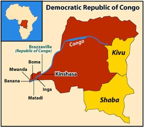
- a)Kananga
- b)Matadi
- c)I don't know
- d)Both of them
Correct answer is option 'B'. Can you explain this answer?
The port city of DRC shown near the capital city in this map is _______.
a)
Kananga
b)
Matadi
c)
I don't know
d)
Both of them
|
|
Aditi Sharma answered |
Matadi, port city, extreme western Democratic Republic of the Congo
Which region in Congo has the world's most extensive tropical rainforest?- a)Savannas
- b)Central basin
- c)Coastal regions
- d)Plateaus
Correct answer is option 'B'. Can you explain this answer?
Which region in Congo has the world's most extensive tropical rainforest?
a)
Savannas
b)
Central basin
c)
Coastal regions
d)
Plateaus
|
|
Stoneridge Institute answered |
The central basin of Congo hosts the world's most extensive tropical rainforest, contributing to the country's rich biodiversity.
What is the most important means of transport in Congo?- a)Rivers
- b)Railways
- c)Airports
- d)Roads
Correct answer is option 'A'. Can you explain this answer?
What is the most important means of transport in Congo?
a)
Rivers
b)
Railways
c)
Airports
d)
Roads
|
|
Stoneridge Institute answered |
Rivers are the most important means of transport in Congo, facilitating trade and transportation.
Where does River Congo flow through in Africa?- a)Mount Kilimanjaro
- b)Sahara Desert
- c)Central Africa
- d)Amazon Rainforest
Correct answer is option 'C'. Can you explain this answer?
Where does River Congo flow through in Africa?
a)
Mount Kilimanjaro
b)
Sahara Desert
c)
Central Africa
d)
Amazon Rainforest
|
|
Stoneridge Institute answered |
River Congo flows through Central Africa. This river is like a big road for boats and it helps connect different places. It's a very important river for the countries around it because it helps with transportation and trade.
State whether the following statement is True or FalseCassava is a root crop used to make bread.- a)True
- b)False
Correct answer is option 'A'. Can you explain this answer?
State whether the following statement is True or False
Cassava is a root crop used to make bread.
a)
True
b)
False

|
Subset Academy answered |
True: Cassava is indeed a root crop that can be dried and pounded into flour, which is then used to make bread.
Additional Fact: Cassava is a staple food for many people and provides important nutrients for a healthy diet.
What is the major climatic characteristic of Congo?- a)Arid desert climate
- b)Mediterranean climate
- c)Humid tropical climate
- d)Tundra climate
Correct answer is option 'C'. Can you explain this answer?
What is the major climatic characteristic of Congo?
a)
Arid desert climate
b)
Mediterranean climate
c)
Humid tropical climate
d)
Tundra climate
|
|
Stoneridge Institute answered |
Congo has a humid tropical climate, characterized by heavy rainfall and warm temperatures throughout the year.
The Democratic Republic of the Congo has an _____ climate.- a)Arctic
- b)Equatorial
- c)Desert
- d)Mediterranean
Correct answer is option 'B'. Can you explain this answer?
The Democratic Republic of the Congo has an _____ climate.
a)
Arctic
b)
Equatorial
c)
Desert
d)
Mediterranean
|
|
Subset Academy answered |
The Democratic Republic of the Congo has an equatorial climate, which means it is very hot and rainy throughout the year. This makes the weather uncomfortable at times because of high humidity. It's generally pleasant in the mornings, very hot at noon, and rainy in the afternoons.
The DRC is the second-largest country in _____.
- a) Africa
- b) Europe
- c) Asia
- d) Australia
Correct answer is option 'A'. Can you explain this answer?
The DRC is the second-largest country in _____.
a)
Africa
b)
Europe
c)
Asia
d)
Australia

|
Gunjan Lakhani answered |
The Democratic Republic of the Congo (DRC) is the second-largest country in Africa. This means it is the second biggest country on the continent of Africa.
Chapter doubts & questions for The Land of Dense Forests: Congo - Social Studies for Class 5 2025 is part of Class 5 exam preparation. The chapters have been prepared according to the Class 5 exam syllabus. The Chapter doubts & questions, notes, tests & MCQs are made for Class 5 2025 Exam. Find important definitions, questions, notes, meanings, examples, exercises, MCQs and online tests here.
Chapter doubts & questions of The Land of Dense Forests: Congo - Social Studies for Class 5 in English & Hindi are available as part of Class 5 exam.
Download more important topics, notes, lectures and mock test series for Class 5 Exam by signing up for free.
Social Studies for Class 5
33 videos|264 docs|50 tests
|
|
© EduRev
|
Education Revolution
|


|


Signup to see your scores
go up
within 7 days!
within 7 days!
Takes less than 10 seconds to signup