


All Exams >
BPSC (Bihar) >
Geography for State PSC Exams >
All Questions
All questions of ATLAS: Map based learning for BPSC (Bihar) Exam

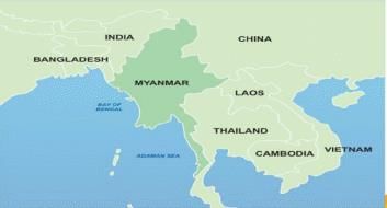
Which of the following are the neighbouring countries of Myanmar?Thailand, Afghanistan, Bangladesh, Bhutan, China, India, Nepal, Pakistan, Laos and Sri Lanka. - a)4
- b)5
- c)6
- d)7
Correct answer is option 'B'. Can you explain this answer?
Which of the following are the neighbouring countries of Myanmar?
Thailand, Afghanistan, Bangladesh, Bhutan, China, India, Nepal, Pakistan, Laos and Sri Lanka.
a)
4
b)
5
c)
6
d)
7
|
|
Rahul Choudhury answered |
Thailand, Bangladesh, India, China, Laos, Thailand
ln which of the following states of India you will find alluvial soil?1. Uttar Pradesh2. Punjab3. Madhya Pradesh4. Assam5. West BengalQ. Choose the correct option- a)1, 2, 5 only
- b)1, 2, 4, 5 only
- c)1, 3, 4, 5 only
- d)1, 2, 3, 4, 5
Correct answer is option 'B'. Can you explain this answer?
ln which of the following states of India you will find alluvial soil?
1. Uttar Pradesh
2. Punjab
3. Madhya Pradesh
4. Assam
5. West Bengal
Q. Choose the correct option
a)
1, 2, 5 only
b)
1, 2, 4, 5 only
c)
1, 3, 4, 5 only
d)
1, 2, 3, 4, 5
|
|
Shalini Desai answered |
Alluvial Soil in India
Alluvial soil is the most fertile soil in India, which is formed by the deposition of silt and clay by the rivers. It is found in the northern plains of India, which includes states like Uttar Pradesh, Punjab, Madhya Pradesh, Assam, and West Bengal.
States of India with Alluvial Soil
Out of the given options, the correct option is (B) 1, 2, 4, 5 only. Let's understand which states have alluvial soil:
1. Uttar Pradesh: The northern plains of India, which includes Uttar Pradesh, has alluvial soil. The soil is formed by the deposition of silt and clay by the rivers like Ganga, Yamuna, and their tributaries.
2. Punjab: The state of Punjab is also located in the northern plains of India, which has alluvial soil. The soil is formed by the deposition of silt and clay by the rivers like Sutlej, Beas, and Ravi.
3. Madhya Pradesh: Unlike Uttar Pradesh and Punjab, Madhya Pradesh is not located in the northern plains of India. It is situated in the Deccan Plateau region and has a different type of soil. Therefore, Madhya Pradesh is not the correct option.
4. Assam: Assam is located in the Brahmaputra valley, which is a part of the northern plains of India. The soil in Assam is alluvial soil, which is formed by the deposition of silt and clay by the Brahmaputra river.
5. West Bengal: West Bengal is also located in the northern plains of India, which has alluvial soil. The soil is formed by the deposition of silt and clay by the rivers like Ganga, Brahmaputra, and their tributaries.
Conclusion
In conclusion, alluvial soil is found in the northern plains of India, which includes states like Uttar Pradesh, Punjab, Assam, and West Bengal. Madhya Pradesh, on the other hand, is not located in the northern plains and therefore does not have alluvial soil.
Arrange the following cities from East to West: - Mandalay
- Kolkata
- Kunming
- Dhaka
Select the correct option from the codes given below:- a)1-3-2-4
- b)3-4-1-2
- c)4-2-1-3
- d)3-1-4-2
Correct answer is option 'D'. Can you explain this answer?
Arrange the following cities from East to West:
- Mandalay
- Kolkata
- Kunming
- Dhaka
Select the correct option from the codes given below:
a)
1-3-2-4
b)
3-4-1-2
c)
4-2-1-3
d)
3-1-4-2
|
|
Arindam Mukherjee answered |
The correct answer is option 'D' (3-1-4-2).
Explanation:
To arrange the cities from East to West, we need to consider their longitudinal positions. The cities with the easternmost longitude should be placed first, followed by cities with progressively western longitudes.
Let's analyze the longitudinal positions of the given cities:
1. Kolkata: Kolkata is located in India and has a longitude of approximately 88.36°E. It is the easternmost city among the given options.
2. Dhaka: Dhaka is the capital city of Bangladesh and has a longitude of approximately 90.41°E. It is slightly west of Kolkata.
3. Kunming: Kunming is located in China and has a longitude of approximately 102.73°E. It is significantly more westward than Kolkata and Dhaka.
4. Mandalay: Mandalay is located in Myanmar and has a longitude of approximately 96.15°E. It is the westernmost city among the given options.
Based on the above analysis, we can arrange the cities from East to West as follows:
3. Kolkata: The easternmost city with a longitude of approximately 88.36°E.
1. Dhaka: Slightly west of Kolkata with a longitude of approximately 90.41°E.
4. Kunming: More westward than Kolkata and Dhaka, with a longitude of approximately 102.73°E.
2. Mandalay: The westernmost city among the given options, with a longitude of approximately 96.15°E.
Therefore, the correct arrangement of the cities from East to West is 3-1-4-2, which corresponds to option 'D'.
Which of the following lakes are correctly matched which the respective countries they are situated in? - Lake Baikal: Russia
- Lake Akan: Indonesia
- Lake Matano: Japan
- Qinghai Lake: China
Select the correct option from the codes given below:- a)1 and 4 only
- b)2 and 3 only
- c)1, 2 and 3 only
- d)2, 3 and 4 only
Correct answer is option 'A'. Can you explain this answer?
Which of the following lakes are correctly matched which the respective countries they are situated in?
- Lake Baikal: Russia
- Lake Akan: Indonesia
- Lake Matano: Japan
- Qinghai Lake: China
Select the correct option from the codes given below:
a)
1 and 4 only
b)
2 and 3 only
c)
1, 2 and 3 only
d)
2, 3 and 4 only
|
|
Mira Dey answered |
Correctly matched lakes with respective countries
Lake Baikal: Russia
Lake Akan: Indonesia
Lake Matano: Japan
Qinghai Lake: China
The correct option is (a) 1 and 4 only.
Explanation:
Lake Baikal is the largest freshwater lake in the world and is located in Russia. It is also considered one of the oldest lakes in the world and is home to a unique ecosystem.
Lake Akan, on the other hand, is located in Japan and is a popular tourist destination known for its natural beauty and hot springs.
Lake Matano is also located in Indonesia and is one of the deepest lakes in the world. It is known for its clear blue waters and unique species of fish.
Qinghai Lake, on the other hand, is located in China and is the largest lake in the country. It is also known as the "Blue Sea" due to its vast size and blue waters.
Therefore, option (a) 1 and 4 only is the correct answer as Lake Baikal is located in Russia and Qinghai Lake is located in China.
The Strait of Tsushima academy between- a) Yellow Sea and East China Sea
- b) East China Sea and Sea of Okhotsk
- c) Sea of Japan and East China Sea
- d) East China Sea and South China Sea
Correct answer is option 'C'. Can you explain this answer?
The Strait of Tsushima academy between
a)
Yellow Sea and East China Sea
b)
East China Sea and Sea of Okhotsk
c)
Sea of Japan and East China Sea
d)
East China Sea and South China Sea
|
|
Mohit Chakraborty answered |
Strait of Tsushima is an important waterway that connects the Sea of Japan and the East China Sea. It lies between the Korean Peninsula and the Japanese island of Kyushu. The correct option among the given choices is (C) Sea of Japan and East China Sea.
Explanation:
- The Strait of Tsushima is a narrow strait that separates Japan from Korea.
- It connects the Sea of Japan (also known as the East Sea) to the west with the East China Sea to the east.
- The Sea of Japan is bordered by Japan to the east, Russia to the north, and the Korean Peninsula to the west. It is an important fishing ground and is also rich in mineral resources.
- The East China Sea is bordered by China to the west and north, Japan to the east, and Taiwan to the south. It is a major shipping route and is also known for its fishing grounds and oil and gas reserves.
- The Strait of Tsushima is an important strategic location for maritime trade and military activities. It is also an important migration route for marine animals such as whales and dolphins.
In conclusion, the correct answer is option (C) Sea of Japan and East China Sea as the Strait of Tsushima lies between these two seas.
How many countries does Sahara Desert covers?- a) 10
- b) 11
- c) 12
- d) 13
Correct answer is option 'B'. Can you explain this answer?
How many countries does Sahara Desert covers?
a)
10
b)
11
c)
12
d)
13
|
|
Sounak Menon answered |
Introduction:
The Sahara Desert is the largest hot desert in the world, covering a vast area of North Africa. It is spread over several countries and is characterized by its extreme aridity and high temperatures.
Countries Covered by Sahara Desert:
The Sahara Desert covers a total of 11 countries in North Africa. These countries are:
1. Algeria
2. Chad
3. Egypt
4. Libya
5. Mali
6. Mauritania
7. Morocco
8. Niger
9. Sudan
10. Tunisia
11. Western Sahara
Geographical Area:
The Sahara Desert covers a total area of about 3.6 million square miles. It is roughly the size of the United States, making it one of the largest deserts in the world. Despite its size, the Sahara is not a uniform expanse of sand, but rather a varied landscape that includes mountains, plateaus, and dunes.
Conclusion:
In conclusion, the Sahara Desert covers a total of 11 countries in North Africa, spanning an area of about 3.6 million square miles. Its extreme aridity and high temperatures make it one of the most inhospitable places on Earth, but it is also home to a unique array of flora and fauna that have adapted to its harsh environment.
Consider the following statements:1. The coastline falls in the rain shadow part of one of the Ghats in the South.2. The name of the coast came from the ancient dynasty of South India.Q. Choose the correct option:- a) Konkan Coast
- b) Coromandel Coast
- c) Malabar Coast
- d) None
Correct answer is option 'B'. Can you explain this answer?
Consider the following statements:
1. The coastline falls in the rain shadow part of one of the Ghats in the South.
2. The name of the coast came from the ancient dynasty of South India.
Q. Choose the correct option:
a)
Konkan Coast
b)
Coromandel Coast
c)
Malabar Coast
d)
None
|
|
Avi Sharma answered |
The correct answer is option 'B', the Coromandel Coast.
Explanation:
The first statement mentions that the coastline falls in the rain shadow part of one of the Ghats in the South. This statement is not specific enough to determine the name of the coast. The western coast of India, known as the Konkan Coast, is located in the rain shadow of the Western Ghats. However, the eastern coast of India, known as the Coromandel Coast, is not influenced by the rain shadow of any Ghats. Therefore, the first statement does not refer to the Konkan Coast.
The second statement mentions that the name of the coast came from the ancient dynasty of South India. This statement is significant in determining the correct answer. The Coromandel Coast derives its name from the ancient Chola dynasty of South India. The Chola dynasty was one of the longest-ruling dynasties in the history of South India and played a significant role in the region's cultural, economic, and political development. The Coromandel Coast, which stretches along the eastern coast of India from Tamil Nadu to Andhra Pradesh, was a prominent territory of the Chola dynasty. Therefore, the second statement refers to the Coromandel Coast.
In conclusion, the correct option is 'B' - the Coromandel Coast. The first statement does not provide enough information to determine the name of the coast, but the second statement links the coast to the ancient Chola dynasty, which is associated with the Coromandel Coast.
Turkey is located between- a) Black Sea and Caspian Sea
- b) Black Sea and Mediterranean Sea
- c) Gulf of Suez and Mediterranean Sea
- d) Gulf of Aqaba and Dead Sea
Correct answer is option 'B'. Can you explain this answer?
Turkey is located between
a)
Black Sea and Caspian Sea
b)
Black Sea and Mediterranean Sea
c)
Gulf of Suez and Mediterranean Sea
d)
Gulf of Aqaba and Dead Sea
|
|
Nishanth Chaudhary answered |
Geographical Location of Turkey
Location: Turkey is a transcontinental country located in Western Asia and Southeastern Europe. It is bordered by eight countries: Greece, Bulgaria, Georgia, Armenia, Azerbaijan, Iran, Iraq, and Syria. It is also surrounded by four seas: the Black Sea to the north, the Mediterranean Sea to the south, the Aegean Sea to the west, and the Sea of Marmara to the northwest.
Correct Answer: The correct answer is option 'B' - Black Sea and Mediterranean Sea. Turkey is located between the Black Sea to the north and the Mediterranean Sea to the south.
Explanation: Turkey is a large country that spans two continents - Europe and Asia. The country is roughly rectangular in shape, and it is widest at its western end, where it is separated from Europe by the Bosporus Strait and the Sea of Marmara. Turkey has a total area of 783,356 square kilometers (302,455 square miles) and a population of approximately 84 million people.
The Black Sea is located to the north of Turkey, and it is connected to the Mediterranean Sea by the Bosporus Strait and the Dardanelles Strait. The Black Sea is an important body of water for Turkey, as it provides access to the Caucasus region and Central Asia. The Black Sea also serves as a major shipping route for Turkish exports.
The Mediterranean Sea is located to the south of Turkey, and it is an important body of water for the country's tourism industry. The Turkish Riviera, located along the Mediterranean coast, is a popular destination for tourists from around the world. The Mediterranean Sea is also an important trade route for Turkey, as it provides access to markets in Europe, Africa, and the Middle East.
In conclusion, Turkey is located between the Black Sea to the north and the Mediterranean Sea to the south. These two bodies of water are important for Turkey's economy, as they provide access to important markets and shipping routes.

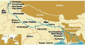
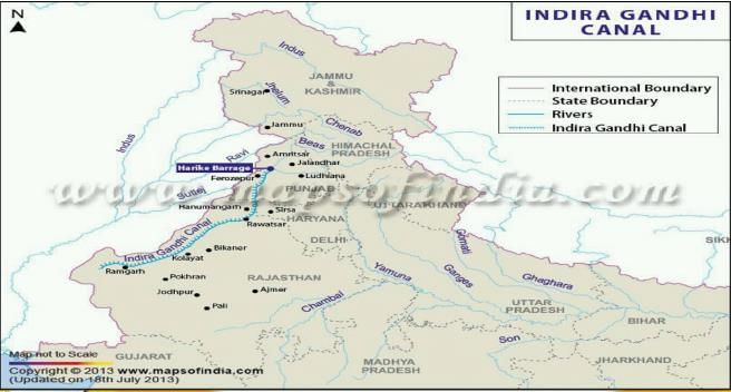
The Indira Gandhi Canal originates near to- a) Chenab and Sutlej Confluence
- b) Chenab and Beas Confluence
- c) Satluj and Beas Confluence
- d) Ravi and Chenab Confluence
Correct answer is option 'C'. Can you explain this answer?
The Indira Gandhi Canal originates near to
a)
Chenab and Sutlej Confluence
b)
Chenab and Beas Confluence
c)
Satluj and Beas Confluence
d)
Ravi and Chenab Confluence
|
|
Sanvi Kapoor answered |
- The Indira Gandhi Canal is one of the largest canal projects in India. It starts from the Harike Barrage at Harike. a few kilometers below the confluence of the Satluj and Beas rivers in the Indian state of Punjab and terminates in irrigation facilities in the Thar Desert in the north west of Rajasthan state. Previously known as the Rajasthan Canal, it was renamed the Indira Gandhi Canal in 1985 following the assassination of Prime Minister Indira Gandhi.
- The canal enters Haryana from Punjab near Lohgarh village then runs through the western part of the Sirsa district before entering Rajasthan near Kharakhera village in the Tibbi tehsil of the Hanumangarh district.
- The canal traverses seven districts of Rajasthan: Barmer, Bikaner, hanumangarh, Jaisalmer, Jodhpur, and Sriganganagar.
Caspian Sea is surrounded by how many countries?- a) 4
- b) 5
- c) 3
- d) 6
Correct answer is option 'B'. Can you explain this answer?
Caspian Sea is surrounded by how many countries?
a)
4
b)
5
c)
3
d)
6
|
|
Gargi Mukherjee answered |
The Caspian Sea is the largest enclosed inland body of water in the world. It is located between Europe and Asia and is bordered by five countries. The correct answer is option B, i.e., five countries.
Countries bordering the Caspian Sea:
1. Russia: The Caspian Sea's northernmost point touches Russia's southern border.
2. Kazakhstan: The Caspian Sea makes up a significant portion of the country's western border.
3. Turkmenistan: The eastern part of the Caspian Sea borders with Turkmenistan.
4. Iran: The southern part of the Caspian Sea borders with Iran.
5. Azerbaijan: The Caspian Sea makes up a significant portion of Azerbaijan's eastern border.
Hence, the Caspian Sea is surrounded by five countries, making option B the correct answer.
Which of the following are the neighboring countries of Sierra Leo?1. Cote D’ Ivoire2. Guinea3. Liberia4. Senegal- a) 2, 3 only
- b) 3, 4 only
- c) 1, 3, 4 only
- d) 1, 2, 3, 4
Correct answer is option 'A'. Can you explain this answer?
Which of the following are the neighboring countries of Sierra Leo?
1. Cote D’ Ivoire
2. Guinea
3. Liberia
4. Senegal
a)
2, 3 only
b)
3, 4 only
c)
1, 3, 4 only
d)
1, 2, 3, 4
|
|
Devanshi Gupta answered |
Neighboring countries of Sierra Leone
Sierra Leone is a country located in West Africa. It shares its borders with four neighboring countries.
The neighboring countries of Sierra Leone are:
1. Guinea
2. Liberia
Therefore, option A is the correct answer as it includes only the neighboring countries 2 and 3.
Option C includes neighboring country 1, which is incorrect as Sierra Leone does not share a border with Cote D'Ivoire. Option D includes all four neighboring countries, which is also incorrect as Sierra Leone does not share a border with Senegal.
The country of Bhutan is surrounded by- a) China, Nepal, Bangladesh and West Bengal
- b) Nepal, China and India
- c) India, China and Tibet
- d) India and China
Correct answer is option 'D'. Can you explain this answer?
The country of Bhutan is surrounded by
a)
China, Nepal, Bangladesh and West Bengal
b)
Nepal, China and India
c)
India, China and Tibet
d)
India and China
|
|
Rhea Reddy answered |
It is landlocked between Tibet Autonomous Region - north and Indian states of Sikkim, WB, Assam and Arunachal Pradesh.
Which country in Asia continent is known as 'Land of Golden Fibre'?- a) Bangladesh
- b) Indonesia
- c) Malaysia
- d) China
Correct answer is option 'A'. Can you explain this answer?
Which country in Asia continent is known as 'Land of Golden Fibre'?
a)
Bangladesh
b)
Indonesia
c)
Malaysia
d)
China
|
|
Suresh Reddy answered |
Bangladesh is one of the largest jute producing countries in the world. Jute is called the Golden Fibre of Bangladesh.
Consider the following statements:1. This is the national park which was established by Britishers in India.2. The governing body of this national park is Project Tiger.3. Fauna founds includes Tiger, Golden Jackal,Indian Pangolins ,Elephants etc.Choose the correct option - a) Dudhwa National Park
- b) Pilibhit National
- c) Periyar National Park
- d) Corbett National Park
Correct answer is option 'D'. Can you explain this answer?
Consider the following statements:
1. This is the national park which was established by Britishers in India.
2. The governing body of this national park is Project Tiger.
3. Fauna founds includes Tiger, Golden Jackal,Indian Pangolins ,Elephants etc.
Choose the correct option
a)
Dudhwa National Park
b)
Pilibhit National
c)
Periyar National Park
d)
Corbett National Park
|
|
Prashanth Mehta answered |
Explanation:
The correct option is 'D', which is Corbett National Park.
- Corbett National Park was established in 1936 by Britishers in India. It is located in the Nainital district of Uttarakhand, India.
- The governing body of Corbett National Park is Project Tiger, which is a wildlife conservation program launched by the Government of India in 1973 to protect tigers in the country.
- Corbett National Park is home to a wide range of flora and fauna. Some of the animals found in the park include Bengal tigers, Indian elephants, golden jackals, Indian pangolins, and many species of birds and reptiles.
In summary, Corbett National Park is a famous national park in India established by Britishers and governed by Project Tiger. It is home to a diverse range of flora and fauna, including tigers, elephants, and many other animals.
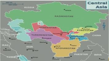
Aral Sea is enclosed between which of the following two countries?- a)Azerbaijan and Kazakhstan
- b)Uzbekistan and Azerbaijan
- c)Uzbekistan and Kazakhstan
- d)Turkmenistan and Kazakhstan
Correct answer is option 'C'. Can you explain this answer?
Aral Sea is enclosed between which of the following two countries?
a)
Azerbaijan and Kazakhstan
b)
Uzbekistan and Azerbaijan
c)
Uzbekistan and Kazakhstan
d)
Turkmenistan and Kazakhstan
|
|
Muskaan Patel answered |
The Aral Sea is enclosed between Uzbekistan and Kazakhstan.
Explanation:
The Aral Sea is a landlocked body of water located in Central Asia. It was once one of the largest lakes in the world, covering an area of about 68,000 square kilometers. However, due to human activities such as irrigation projects and the diversion of rivers, the Aral Sea has been shrinking since the 1960s and has lost a significant amount of its water volume.
- Location of the Aral Sea:
The Aral Sea is located in the southern part of Kazakhstan and the northern part of Uzbekistan. It is situated in the low-lying flatlands of Central Asia, between the vast deserts of Karakum to the south and the Kyzylkum to the east.
- Uzbekistan and the Aral Sea:
The eastern part of the Aral Sea lies within the territory of Uzbekistan. In the past, the Aral Sea was divided into two separate basins, the Small Aral Sea in the north and the Large Aral Sea in the south. However, due to the extensive water withdrawals from the rivers that feed the sea, the two basins have become distinct bodies of water.
- Kazakhstan and the Aral Sea:
The western part of the Aral Sea falls within the borders of Kazakhstan. The shrinking of the Aral Sea has had severe environmental and socio-economic consequences for the people living in the region. The exposed seabed has resulted in the release of toxic salts and chemicals into the air, leading to a range of health issues for the local population.
In conclusion, the Aral Sea is enclosed between Uzbekistan to the east and Kazakhstan to the west. The two countries share the responsibility of addressing the environmental challenges posed by the shrinking of the sea and working towards sustainable solutions for the future.
Which is the only Great Lake to be located entirely within the United States?- a)Lake Erie
- b)Lake Huron
- c)Lake Ontario
- d)Lake Michigan
Correct answer is option 'D'. Can you explain this answer?
Which is the only Great Lake to be located entirely within the United States?
a)
Lake Erie
b)
Lake Huron
c)
Lake Ontario
d)
Lake Michigan
|
|
Anita Desai answered |
Lake Michigan is the only Great Lake to be located entirely within the United States.
Which of the following Mountain Range is not located in United States?
- a)Alaska Range
- b)Young Ranges of the St. Elias Mountains
- c)Brooks Range
- d)None of these
Correct answer is option 'B'. Can you explain this answer?
Which of the following Mountain Range is not located in United States?
a)
Alaska Range
b)
Young Ranges of the St. Elias Mountains
c)
Brooks Range
d)
None of these
|
|
Sai Sengupta answered |
The correct answer is option 'B': Young Ranges of the St. Elias Mountains.
The St. Elias Mountains are located in North America, specifically in the southwestern part of Yukon in Canada and the southeastern part of Alaska in the United States. This mountain range is known for its vast size and rugged terrain. It is part of the larger Pacific Coast Ranges, which extend from Alaska to California.
Let's break down the options and analyze each mountain range to determine which one is not located in the United States:
a) Sierra Nevada:
The Sierra Nevada is a prominent mountain range located in the western United States, primarily in the state of California. It stretches over 400 miles and is known for its stunning peaks, including Mount Whitney, the highest summit in the contiguous United States. The Sierra Nevada is famous for its natural beauty and is a popular destination for outdoor activities such as hiking and skiing.
b) Young Ranges of the St. Elias Mountains:
As mentioned earlier, the St. Elias Mountains are situated in both Canada and the United States. The Young Ranges refer to a section within the St. Elias Mountains, and they are indeed located in North America. Therefore, this option is incorrect.
c) Brooks Range:
The Brooks Range is a mountain range that spans across northern Alaska. It extends for approximately 700 miles from west to east and is part of the Arctic Cordillera. This range is known for its remote and untouched wilderness, with vast tundra, rugged peaks, and abundant wildlife. The Brooks Range is an important habitat for various species, including caribou, grizzly bears, and wolves.
d) Alaska Range:
The Alaska Range is another significant mountain range located in the state of Alaska. It stretches for about 400 miles and includes several notable peaks, including Mount McKinley, also known as Denali, the highest peak in North America. The Alaska Range is renowned for its breathtaking scenery and challenging climbing opportunities.
In conclusion, the correct answer is option 'B': Young Ranges of the St. Elias Mountains. This mountain range is part of the St. Elias Mountains, which are located in both Canada and the United States.
Consider the following statements: - Dardanelles Strait links Sea of Marmara with Aegean Sea.
- The Aegean is located between between the mainlands of Greece,Bulgaria and Turkey.
Which of the above statement/s is/are correct?- a)1 only
- b)2 only
- c)Both 1 and 2
- d)Neither 1 nor 2
Correct answer is option 'A'. Can you explain this answer?
Consider the following statements:
- Dardanelles Strait links Sea of Marmara with Aegean Sea.
- The Aegean is located between between the mainlands of Greece,Bulgaria and Turkey.
Which of the above statement/s is/are correct?
a)
1 only
b)
2 only
c)
Both 1 and 2
d)
Neither 1 nor 2
|
|
Muskaan Patel answered |
Answer:
The correct answer is option 'A' - 1 only.
Explanation:
- The Dardanelles Strait is a narrow strait in northwestern Turkey that connects the Sea of Marmara with the Aegean Sea. It separates the European and Asian parts of Turkey and is an important international waterway for shipping.
- The Aegean Sea, on the other hand, is located between the mainlands of Greece and Turkey. It is bounded by the Greek islands on the west and the coasts of Turkey on the east.
- However, Bulgaria does not have a coastline on the Aegean Sea. It is located to the north of Greece and does not directly border the Aegean Sea.
- Therefore, the second statement is incorrect as it falsely includes Bulgaria as one of the countries located between the mainlands of Greece, Bulgaria, and Turkey.
- The first statement is correct as the Dardanelles Strait does indeed link the Sea of Marmara with the Aegean Sea.
To summarize:
- Statement 1: The Dardanelles Strait links the Sea of Marmara with the Aegean Sea. This is correct.
- Statement 2: The Aegean Sea is located between the mainlands of Greece, Bulgaria, and Turkey. This is incorrect.
Hence, the correct answer is option 'A' - 1 only.
Which among the following is the coastal water body that lies off the Southwest coast of India, north of a line extending from the Southern point of Srijanka to the southernmost of the Maldives Islands and east of the Maldives?- a) Gulf of Mannar
- b) Laccadive sea
- c) Palk Strait
- d) Minicoy
Correct answer is option 'B'. Can you explain this answer?
Which among the following is the coastal water body that lies off the Southwest coast of India, north of a line extending from the Southern point of Srijanka to the southernmost of the Maldives Islands and east of the Maldives?
a)
Gulf of Mannar
b)
Laccadive sea
c)
Palk Strait
d)
Minicoy

|
Charvi Banerjee answered |
Laccadive Sea
The Laccadive Sea is the coastal water body that lies off the Southwest coast of India, north of a line extending from the Southern point of Sri Lanka to the southernmost of the Maldives Islands and east of the Maldives. Here are some key points about the Laccadive Sea:
Location
- The Laccadive Sea is located in the Indian Ocean, to the southwest of India.
- It is bounded by the southwestern coast of India, Sri Lanka, and the Maldives.
Islands
- The Laccadive Sea is home to several islands, including the Lakshadweep Islands and the Maldives.
- These islands are known for their stunning beaches, coral reefs, and marine biodiversity.
Marine Life
- The Laccadive Sea is rich in marine life, with a variety of fish, corals, and other sea creatures.
- It is a popular diving and snorkeling destination, attracting tourists from around the world.
Importance
- The Laccadive Sea is an important water body for the region, supporting fishing, tourism, and maritime trade.
- It plays a key role in the economy and ecology of the surrounding areas.
In conclusion, the Laccadive Sea is a vital coastal water body off the Southwest coast of India, known for its islands, marine life, and economic significance.
Foveaux is a strait in between?- a)Stewart Island & South Island
- b)Japan sea & Okhotsk sea
- c)Gulf of Mexico & Caribbean sea
- d)Java sea & Indian ocean
Correct answer is option 'A'. Can you explain this answer?
Foveaux is a strait in between?
a)
Stewart Island & South Island
b)
Japan sea & Okhotsk sea
c)
Gulf of Mexico & Caribbean sea
d)
Java sea & Indian ocean
|
|
Saranya Dey answered |
Location of Foveaux Strait
The Foveaux Strait is located between Stewart Island and the South Island of New Zealand. It is an important waterway that connects the Tasman Sea to the south with the Pacific Ocean to the north.
Geography and Importance
- The Foveaux Strait is approximately 130 kilometers long and varies in width from 15 to 45 kilometers.
- It is known for its often rough and unpredictable waters due to strong tidal currents and winds.
- The strait is a crucial shipping route for vessels traveling between the South Island and Stewart Island, as well as for fishing and tourism activities in the region.
- The waters of the Foveaux Strait are rich in marine life, including various species of fish, seals, and seabirds.
Connection to Stewart Island and South Island
- Stewart Island, located to the south of the Foveaux Strait, is the third-largest island in New Zealand and is known for its rugged landscapes and pristine wilderness.
- The South Island, to the north of the strait, is the larger of the two main islands of New Zealand and is famous for its stunning scenery, including mountains, fjords, and glaciers.
Conclusion
The Foveaux Strait plays a significant role in the maritime activities and ecosystems of New Zealand, connecting the South Island with Stewart Island and providing a vital link between the Tasman Sea and the Pacific Ocean. Its unique geography and rich marine life make it a region of great importance and interest.
Where is the famous Easter island located?- a) Atlantic ocean
- b) Indian ocean
- c) Arctic ocean
- d) Pacific ocean
Correct answer is option 'D'. Can you explain this answer?
Where is the famous Easter island located?
a)
Atlantic ocean
b)
Indian ocean
c)
Arctic ocean
d)
Pacific ocean
|
|
Vikram Verma answered |
Located out in the Pacific ocean, a special territory of chile, is a home to Moai statues that are the only thing left of a culture that once lived here.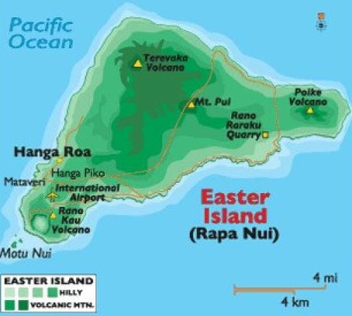
Located in the south-eastern Pacific ocean, at the southeastern most point of the Polynesian Triangle in Oceania.
Which strait separates the Gulf of Aqaba from the Red Sea?- a) Strait of Hormuz
- b) Straits of Tiran
- c) Bering Strait
- d) Cook Strait
Correct answer is option 'B'. Can you explain this answer?
Which strait separates the Gulf of Aqaba from the Red Sea?
a)
Strait of Hormuz
b)
Straits of Tiran
c)
Bering Strait
d)
Cook Strait
|
|
Poonam Reddy answered |
It's a narrow passage between Sinai and Arabian peninsulas which separates Gulf of Aqaba from the Red Sea.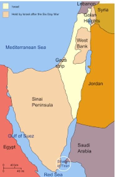
Which are the boundaries shared by the Sea of Azov?1. Ukraine2. Russia 3. Crimean Peninsula4. Turkey- a)1, 2 & 4
- b)1, 2 & 3
- c)3 & 4
- d)all the above
Correct answer is option 'B'. Can you explain this answer?
Which are the boundaries shared by the Sea of Azov?
1. Ukraine
2. Russia
3. Crimean Peninsula
4. Turkey
a)
1, 2 & 4
b)
1, 2 & 3
c)
3 & 4
d)
all the above
|
|
Aashna Singh answered |
Boundaries Shared by the Sea of Azov
The Sea of Azov is bordered by several countries and regions, each sharing different boundaries with this body of water.
- Ukraine
The Sea of Azov shares its boundary with Ukraine to the north and northwest. The northern coast of the sea is primarily Ukrainian territory, with cities like Mariupol and Berdyansk located along the coast.
- Russia
To the east and northeast of the Sea of Azov lies Russia. The Russian Federation has control over the eastern coast of the sea, including the port city of Taganrog. The two countries have had disputes over the control of the sea and its resources.
- Crimean Peninsula
The Crimean Peninsula is located to the south of the Sea of Azov and is currently under Russian control. The peninsula is connected to the mainland by the narrow Kerch Strait, which connects the Sea of Azov to the Black Sea.
Therefore, the boundaries shared by the Sea of Azov include Ukraine, Russia, and the Crimean Peninsula, making option 'B' the correct answer.
Which one of the following pairs of States of India indicates the easternmost and western most State?- a) Assam and Rajasthan
- b) Arunachal Pradesh and Rajasthan
- c) Assam and Gujarat
- d) Arunachal Pradesh and Gujarat
Correct answer is option 'D'. Can you explain this answer?
Which one of the following pairs of States of India indicates the easternmost and western most State?
a)
Assam and Rajasthan
b)
Arunachal Pradesh and Rajasthan
c)
Assam and Gujarat
d)
Arunachal Pradesh and Gujarat
|
|
Palak Pillai answered |
Easternmost and Westernmost States of India
The easternmost and westernmost States of India are Arunachal Pradesh and Gujarat, respectively.
Arunachal Pradesh:
- Arunachal Pradesh is located in the northeastern part of India.
- It shares its borders with Bhutan in the west, China in the north, and Myanmar in the east.
- The state's easternmost point is Kibithu, which is located in the Anjaw district.
Gujarat:
- Gujarat is located in the western part of India.
- It shares its borders with Rajasthan in the north, Maharashtra in the south, and the Arabian Sea in the west.
- The state's westernmost point is the Sir Creek, which is located in the Kutch district.
Conclusion:
In conclusion, Arunachal Pradesh and Gujarat are the easternmost and westernmost States of India, respectively. Arunachal Pradesh's easternmost point is Kibithu, located in the Anjaw district, and Gujarat's westernmost point is the Sir Creek, located in the Kutch district.
Choose the correct match:Dams-Rivers1. Govind Ballabh Pant Sagar- Rihand2. Hirakund -Mahanadi3. Nagarjuna Sagar- Kaveri- a)1, 2 only
- b)2, 3 only
- c)1, 3 only
- d)1, 2, 3
Correct answer is option 'A'. Can you explain this answer?
Choose the correct match:
Dams-Rivers
1. Govind Ballabh Pant Sagar- Rihand
2. Hirakund -Mahanadi
3. Nagarjuna Sagar- Kaveri
a)
1, 2 only
b)
2, 3 only
c)
1, 3 only
d)
1, 2, 3
|
|
Mihir Chavan answered |
The correct match for the dams and rivers is:
1. Govind Ballabh Pant Sagar - Rihand
2. Hirakud - Mahanadi
3. Nagarjuna Sagar - Krishna
Explanation:
1. Govind Ballabh Pant Sagar - Rihand:
- Govind Ballabh Pant Sagar, also known as Rihand Dam, is located on the Rihand River in the state of Uttar Pradesh.
- It is the largest reservoir in India and forms the border between Uttar Pradesh and Madhya Pradesh.
- The dam was constructed for multiple purposes including irrigation, hydroelectric power generation, and flood control.
2. Hirakud - Mahanadi:
- Hirakud Dam is situated on the Mahanadi River in the state of Odisha.
- It is one of the longest dams in the world and was built for flood control, irrigation, and hydroelectric power generation.
- The dam has created a large reservoir called Hirakud Reservoir, which is one of the largest artificial lakes in Asia.
3. Nagarjuna Sagar - Krishna:
- Nagarjuna Sagar Dam is built on the Krishna River in the state of Telangana and Andhra Pradesh.
- It is one of the largest masonry dams in the world and is a major source of irrigation and hydroelectric power generation in the region.
- The dam forms a large reservoir called Nagarjuna Sagar Reservoir, which is known for its scenic beauty and is a popular tourist destination.
In conclusion, the correct match for the dams and rivers is option 'A' - 1, 2 only. Govind Ballabh Pant Sagar is associated with the Rihand River, and Hirakud is associated with the Mahanadi River. Nagarjuna Sagar is associated with the Krishna River, not the Kaveri River as mentioned in option 3.
Which of the given country / ies are land locked?1. South Sudan2. Botswana3. Angola4. GabonQ. Choose the correct option- a)1 only
- b)2, 3 only
- c)1, 2 only
- d)1, 3, 4 only
Correct answer is option 'C'. Can you explain this answer?
Which of the given country / ies are land locked?
1. South Sudan
2. Botswana
3. Angola
4. Gabon
Q. Choose the correct option
a)
1 only
b)
2, 3 only
c)
1, 2 only
d)
1, 3, 4 only
|
|
Sneha Shah answered |
Landlocked countries are those that do not have direct access to the sea. They are completely surrounded by land, making it more challenging for them to engage in international trade and access maritime resources. In this case, South Sudan and Botswana are the only two landlocked countries out of the given options.
South Sudan:
South Sudan is a landlocked country located in East-Central Africa. It gained independence from Sudan in 2011 and is the youngest country in the world. As it does not have any coastline, it is entirely surrounded by six neighboring countries: Sudan to the north, Ethiopia to the east, Kenya to the southeast, Uganda to the south, the Democratic Republic of the Congo to the southwest, and the Central African Republic to the west.
Botswana:
Botswana is a landlocked country located in Southern Africa. It is bordered by four countries: Namibia to the west and north, South Africa to the south, Zimbabwe to the northeast, and Zambia to the north. Despite being landlocked, Botswana has managed to thrive economically due to its rich diamond resources and stable governance.
Angola:
Angola is not a landlocked country. It is located on the west coast of Southern Africa and has a coastline along the Atlantic Ocean. It shares its borders with Namibia to the south, the Democratic Republic of the Congo to the north, and Zambia to the east.
Gabon:
Gabon is also not a landlocked country. It is situated on the west coast of Central Africa and has a coastline along the Atlantic Ocean. It shares its borders with Equatorial Guinea to the northwest and north, Cameroon to the north, and the Republic of the Congo to the east and south.
In conclusion, South Sudan and Botswana are the only landlocked countries among the given options.
Which of the following rivers does not drain their water in Pacifi c Ocean?- a)Gila river
- b)Colorado river
- c)Fraser river
- d)Mississippi River
Correct answer is option 'D'. Can you explain this answer?
Which of the following rivers does not drain their water in Pacifi c Ocean?
a)
Gila river
b)
Colorado river
c)
Fraser river
d)
Mississippi River
|
|
Pooja Choudhury answered |
Mississippi River drains its water in Gulf of Mexico
- Gila river is a tributary of Colorado river and their water drains into Pacifi c Ocean
- Colorado River, major river of North America, rising in the Rocky Mountains of Colorado, U.S., and fl owing generally west and south for 1,450 miles (2,330 kilometres) into the Gulf of California in north-western Mexico.
- The Fraser River is a river within British Columbia, Canada, rising at Fraser Pass near Blackrock Mountain in the Rocky Mountains and fl owing for 1,375 kilometres (854 mi), into the Strait of Georgia.
Which passage connects southwestern- Atlantic Ocean with south-eastern-Pacific Ocean?- a) Drake Passage
- b) Khardung La Passage
- c) Zoji La Passage
- d) Chanchal Passage
Correct answer is option 'A'. Can you explain this answer?
Which passage connects southwestern- Atlantic Ocean with south-eastern-Pacific Ocean?
a)
Drake Passage
b)
Khardung La Passage
c)
Zoji La Passage
d)
Chanchal Passage
|
|
Ravi Sharma answered |
Drake Passage is a body of water between South America Cape Horn and South Shetland Islands of Antarctica. It connects southwestern part of the Atlantic Ocean with the southeastern part of Pacific Ocean and it extends into the Southern Ocean.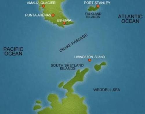
The endangered olive Ridley turtles have the world's largest aggregation at- a) Gahirmatha
- b) Sagarmatha
- c) Lakshadweep Islands
- d) Andaman and Nicobar Islands
Correct answer is option 'A'. Can you explain this answer?
The endangered olive Ridley turtles have the world's largest aggregation at
a)
Gahirmatha
b)
Sagarmatha
c)
Lakshadweep Islands
d)
Andaman and Nicobar Islands
|
|
Keerthana Rane answered |
Explanation:
Gahirmatha:
Gahirmatha beach in Odisha is known to have the world's largest aggregation of endangered olive Ridley turtles. This beach serves as a crucial nesting site for these turtles.
Importance:
The olive Ridley turtles gather in large numbers at Gahirmatha beach every year for mass nesting, known as arribada. This phenomenon is a critical event for the conservation of these turtles.
Conservation Efforts:
Due to the significance of Gahirmatha beach for olive Ridley turtles, conservation efforts have been implemented to protect the nesting site and ensure the safety of the turtles during the nesting season.
Challenges:
Despite conservation measures, these turtles face various threats such as habitat loss, pollution, and accidental capture in fishing nets. Continued efforts are needed to safeguard the population of olive Ridley turtles at Gahirmatha beach.
In conclusion, Gahirmatha beach in Odisha stands out as the world's largest aggregation site for endangered olive Ridley turtles, highlighting the importance of conservation initiatives to protect these marine species.
Which of the following basin is intermountain basin?- a) Qaidam Basin
- b) Tarim Basin
- c) Jubba - Shebelle basin
- d) Rio Grandae
Correct answer is option 'A'. Can you explain this answer?
Which of the following basin is intermountain basin?
a)
Qaidam Basin
b)
Tarim Basin
c)
Jubba - Shebelle basin
d)
Rio Grandae
|
|
Ameya Desai answered |
Introducing Intermountain Basin
The Intermountain Basin is a region characterized by a series of interconnected basins located between the Rocky Mountains and various mountain ranges in the western United States. These basins are known for their unique geographical features and play a significant role in the region's hydrology and ecology.
The Correct Answer: Qaidam Basin
Among the given options, the Qaidam Basin is the correct answer for the Intermountain Basin. Let's explore the characteristics of the Qaidam Basin and understand why it is considered an Intermountain Basin.
1. Qaidam Basin:
The Qaidam Basin is located in western China, specifically in Qinghai province. It is surrounded by mountain ranges, including the Kunlun Mountains to the south, the Qilian Mountains to the northeast, and the Altun Mountains to the northwest. These mountain ranges form a natural boundary around the basin, making it an intermountain basin.
2. Geography and Geology:
The Qaidam Basin spans an area of approximately 120,000 square kilometers, making it one of the largest intermountain basins in the world. It is situated at an average elevation of around 2,800 meters above sea level, making it a high-altitude basin. The basin is primarily composed of sediments deposited over millions of years, resulting in a diverse range of geological formations.
3. Hydrology and Climate:
The Qaidam Basin is a closed basin, meaning it has no outlet for drainage. It is characterized by numerous saline lakes, such as Qinghai Lake, which are fed by rivers and streams flowing from the surrounding mountains. The region experiences a cold desert climate, with low precipitation and extreme temperature variations between day and night.
4. Economic Significance:
The Qaidam Basin is rich in natural resources, including vast reserves of oil, natural gas, and minerals such as salt, potassium, and boron. These resources have played a crucial role in the economic development of the region, with extensive mining and extraction activities taking place in the basin.
Conclusion:
The Qaidam Basin is a prime example of an intermountain basin due to its location between mountain ranges, its closed hydrological system, and its unique geological and ecological characteristics. Understanding the features and significance of the Qaidam Basin helps us identify it as the correct answer among the given options for an intermountain basin.
In which one of the following places is the Shompen tribe found?- a) Nilgiri hills
- b) Nicobar Islands
- c) Spiti valley
- d) Lakshadweep Islands
Correct answer is option 'B'. Can you explain this answer?
In which one of the following places is the Shompen tribe found?
a)
Nilgiri hills
b)
Nicobar Islands
c)
Spiti valley
d)
Lakshadweep Islands
|
|
Gauri Chakraborty answered |
Shompen Tribe in Nicobar Islands
The Shompen tribe is found in the Nicobar Islands, which is an archipelago in the eastern Indian Ocean. Here is an explanation of why the Shompen tribe is found in the Nicobar Islands:
- Nicobar Islands:
- The Nicobar Islands are a group of islands located in the eastern part of the Bay of Bengal.
- These islands are a part of the Union Territory of India and are known for their unique culture and biodiversity.
- Shompen Tribe:
- The Shompen tribe is one of the indigenous tribes that inhabit the Nicobar Islands.
- They are believed to be one of the oldest tribes in the region with a distinct culture and way of life.
- The Shompen tribe has traditionally been hunter-gatherers, relying on the rich natural resources of the islands for their sustenance.
- Isolation:
- The Shompen tribe has remained relatively isolated from the outside world, which has helped them preserve their unique cultural practices and traditions.
- Due to their isolation, not much is known about the exact population size or specific customs of the Shompen tribe.
In conclusion, the Shompen tribe is found in the Nicobar Islands, where they have lived for centuries, maintaining their cultural heritage and way of life in this remote and beautiful part of India.
The Wallace's line separates the flora and fauna between- a) Canada and USA
- b) Taiga region and Tundra region
- c) Mexico and Central America
- d) South-East Asia and Australia
Correct answer is option 'D'. Can you explain this answer?
The Wallace's line separates the flora and fauna between
a)
Canada and USA
b)
Taiga region and Tundra region
c)
Mexico and Central America
d)
South-East Asia and Australia
|
|
Ojasvi Mehta answered |
The Wallace line is a faunal boundary line drawn in 1859 by British naturalist Alfred Russel Wallace and named by Thomas Henry Huxley, that separates the ecozones of Asia and Wallacea, a transitional zone between Asia and Australia.
Which one of the following pairs of islands is separated from each other by the 'Ten Degree Channel'?- a) Andaman and Nicobar
- b) Nicobar and Sumatra
- c) Maldives and Lakshadweep
- d) Sumatra and Java
Correct answer is option 'A'. Can you explain this answer?
Which one of the following pairs of islands is separated from each other by the 'Ten Degree Channel'?
a)
Andaman and Nicobar
b)
Nicobar and Sumatra
c)
Maldives and Lakshadweep
d)
Sumatra and Java
|
|
Nilesh Mehra answered |
Ten Degree Channel Separates Andaman and Nicobar
Introduction:
The 'Ten Degree Channel' is a water body located in the Bay of Bengal. It separates two prominent islands of India - Andaman and Nicobar.
Explanation:
The Ten Degree Channel is a narrow stretch of water body located between Andaman and Nicobar. It is named so because it lies approximately on the 10th degree of latitude. The channel is about 145 km wide and is considered as one of the most important navigational routes in the region.
Other Options:
Option B - Nicobar and Sumatra are separated by the 'Great Channel'.
Option C - Maldives and Lakshadweep are separated by the 'Eight Degree Channel'.
Option D - Sumatra and Java are separated by the Sunda Strait.
Conclusion:
Hence, the correct answer is option A - Andaman and Nicobar.
Which one of the following can one come across if one travels through the Strait of Malacca:- a) Bali
- b) Brunei
- c) Java
- d) Singapore
Correct answer is option 'D'. Can you explain this answer?
Which one of the following can one come across if one travels through the Strait of Malacca:
a)
Bali
b)
Brunei
c)
Java
d)
Singapore
|
|
Devanshi Gupta answered |
Strait of Malacca is a narrow waterway between the Malay Peninsula and the Indonesian island of Sumatra. It is one of the busiest shipping lanes in the world, connecting the Indian Ocean to the Pacific Ocean. If one travels through the Strait of Malacca, one can come across the following:
1. Singapore: Singapore is a city-state and island country located at the southern end of the Malay Peninsula. It is one of the busiest ports in the world and a major financial hub in Southeast Asia. It is located at the southern entrance of the Strait of Malacca.
2. Malaysia: Malaysia is a country located in Southeast Asia, consisting of two regions separated by the South China Sea. The Malay Peninsula is located to the west of the Strait of Malacca, while the Malaysian state of Sabah is located on the island of Borneo to the east of the strait.
3. Indonesia: Indonesia is an archipelago nation consisting of thousands of islands located to the east of the Strait of Malacca, including the island of Sumatra which the strait borders.
4. Other countries: The Strait of Malacca is an important shipping lane for countries around the world, including China, Japan, South Korea, and Australia. Ships traveling through the strait may be carrying goods such as oil, natural gas, and manufactured goods.
In conclusion, if one travels through the Strait of Malacca, one can come across Singapore, Malaysia, Indonesia, and ships from various countries around the world.
Which of the following seas is/are not a part of Pacifi c Ocean? - Sulu Sea
- Arafura Sea
- Kara Sea
- Laptev Sea
Select the correct option from the codes given below:- a)1 and 3 only
- b)2 and 4 only
- c)1 and 2 only
- d)3 and 4 only
Correct answer is option 'D'. Can you explain this answer?
Which of the following seas is/are not a part of Pacifi c Ocean?
- Sulu Sea
- Arafura Sea
- Kara Sea
- Laptev Sea
Select the correct option from the codes given below:
a)
1 and 3 only
b)
2 and 4 only
c)
1 and 2 only
d)
3 and 4 only
|
|
Ananya Deshmukh answered |
Option (d) is correct: Kara and Laptev Sea are a part of Arctic Ocean.
Choose the correct relation:1. Baglihar Dam-Jhelum river2. Krishnaganga Dam-Chenab river3. Uri Dam-Jhelum river- a) 2, 3 only
- b) 1 only
- c) 3 only
- d) 1, 2, 3
Correct answer is option 'C'. Can you explain this answer?
Choose the correct relation:
1. Baglihar Dam-Jhelum river
2. Krishnaganga Dam-Chenab river
3. Uri Dam-Jhelum river
a)
2, 3 only
b)
1 only
c)
3 only
d)
1, 2, 3
|
|
Nisha Nair answered |
Relation between Dams and Rivers
Introduction:
Dams play a crucial role in harnessing the potential of rivers for various purposes like irrigation, hydroelectric power generation, and flood control. In this question, we are given three dams and their corresponding rivers. Let's analyze each of them to determine the correct relation.
1. Baglihar Dam - Jhelum River:
The Baglihar Dam is located on the Jhelum River in the Indian-administered union territory of Jammu and Kashmir. It is a run-of-the-river hydroelectric power project designed to utilize the water resources of the Jhelum River for generating electricity. Therefore, the relation between the Baglihar Dam and the Jhelum River is correct.
2. Krishnaganga Dam - Chenab River:
The Krishnaganga Dam is not associated with the Chenab River. The correct dam associated with the Chenab River is the Salal Dam. The Krishnaganga River is a tributary of the Kali River, which is not related to the Chenab River. Hence, the relation between the Krishnaganga Dam and the Chenab River is incorrect.
3. Uri Dam - Jhelum River:
The Uri Dam is located on the Jhelum River in the Indian-administered union territory of Jammu and Kashmir. It is also a run-of-the-river hydroelectric power project that harnesses the water resources of the Jhelum River. Therefore, the relation between the Uri Dam and the Jhelum River is correct.
Conclusion:
Based on the analysis, the correct relation is Option C: 3 only. The Baglihar Dam and Uri Dam are associated with the Jhelum River, while the Krishnaganga Dam is not related to the Chenab River.
Consider the following statements1. The desert is a rain shadow desert formed by Tibetan plateau.2. The desert is a cold desert which extends in two countries.- a) Taklamakan Desert
- b) Gobi Desert
- c) Polond Desert
- d) Gibson Desert
Correct answer is option 'B'. Can you explain this answer?
Consider the following statements
1. The desert is a rain shadow desert formed by Tibetan plateau.
2. The desert is a cold desert which extends in two countries.
a)
Taklamakan Desert
b)
Gobi Desert
c)
Polond Desert
d)
Gibson Desert
|
|
Ujwal Unni answered |
The Gobi Desert in Mongolia and China is in a rain shadow due to the towering Himalaya mountain range. The Atacama Desert in Chile is in a rain shadow created by both the Andes Mountains and weather patterns over the Pacific Ocean.
Consider the following countries: - Armenia
- Azerbaijan
- Russia
- Uzbekistan
- Romania
- Iraq
Which of the above countries touches the boundary of either the Black Sea or the Caspian Sea?- a)1, 2 and 3 only
- b)4, 5 and 6 only
- c)1, 3 and 5 only
- d)2, 3 and 5 only
Correct answer is option 'D'. Can you explain this answer?
Consider the following countries:
- Armenia
- Azerbaijan
- Russia
- Uzbekistan
- Romania
- Iraq
Which of the above countries touches the boundary of either the Black Sea or the Caspian Sea?
a)
1, 2 and 3 only
b)
4, 5 and 6 only
c)
1, 3 and 5 only
d)
2, 3 and 5 only
|
|
Jaya Nair answered |
Option (d) is correct: Iraq, Uzbekistan and Armenia does not touch the boundary of either the Black Sea or the Caspian Sea.
The Caspian Sea and Black Sea
- The Caspian Sea: The Caspian Sea is the Earth’s largest inland body of water. It lies at the junction of Europe and Asia, with the Caucasus Mountains to the west and the steppes of Central Asia to the east. It is bordered by Russia to the northwest, Azerbaijan to the west, Iran to the south, Turkmenistan to the southeast and Kazakhstan to the northeast.
- Black Sea: The world’s most isolated sea, the Black Sea, is connected to the oceans via the Mediterranean through the Bosphorus, and linked with the Sea of Azov in the northeast through the Kerch Strait. Its catchment area covers an area six times larger than its surface. The Danube discharges into the Black Sea at the Danube Delta, thus Danube water quality is directly connected with the Black Sea’s status. The Black Sea Protection Commission is responsible for the sea’s sustainable management. The countries share a border with the Black Sea includes Romania, Turkey, Bulgaria, Ukraine, Russia, and Georgia. This body of water is also surrounded by the Pontic, Caucasus, and Crimean Mountains in the south, east and north respectively. It is also constrained by Strandzha mountains to the southwest and Dobrogea Plateau to the northwest.
Which of the following important cities are correctly matched with their respective countries? - Dushanbe: Tajikistan
- Ashgabat: Uzbekistan
- Alma-Ata: Kazakhstan
- Bishkek: Kyrgyzstan
Select the correct option from the codes given below:- a)1, 3 and 4 only
- b)2, 3 and 4 only
- c)1, 2 and 3 only
- d)1, 2 and 4 only
Correct answer is option 'A'. Can you explain this answer?
Which of the following important cities are correctly matched with their respective countries?
- Dushanbe: Tajikistan
- Ashgabat: Uzbekistan
- Alma-Ata: Kazakhstan
- Bishkek: Kyrgyzstan
Select the correct option from the codes given below:
a)
1, 3 and 4 only
b)
2, 3 and 4 only
c)
1, 2 and 3 only
d)
1, 2 and 4 only
|
|
Arun Khatri answered |
Ashgabat is in Turkmenistan.
Chapter doubts & questions for ATLAS: Map based learning - Geography for State PSC Exams 2025 is part of BPSC (Bihar) exam preparation. The chapters have been prepared according to the BPSC (Bihar) exam syllabus. The Chapter doubts & questions, notes, tests & MCQs are made for BPSC (Bihar) 2025 Exam. Find important definitions, questions, notes, meanings, examples, exercises, MCQs and online tests here.
Chapter doubts & questions of ATLAS: Map based learning - Geography for State PSC Exams in English & Hindi are available as part of BPSC (Bihar) exam.
Download more important topics, notes, lectures and mock test series for BPSC (Bihar) Exam by signing up for free.
Geography for State PSC Exams
185 videos|761 docs|272 tests
|
|
© EduRev
|
Education Revolution
|


|


Signup to see your scores
go up
within 7 days!
within 7 days!
Takes less than 10 seconds to signup