


All Exams >
SSC CGL >
General Awareness for SSC CGL >
All Questions
All questions of Additional Learning Material for Maps for SSC CGL Exam

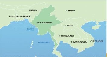
Which of the following are the neighbouring countries of Myanmar?Thailand, Afghanistan, Bangladesh, Bhutan, China, India, Nepal, Pakistan, Laos and Sri Lanka. - a)4
- b)5
- c)6
- d)7
Correct answer is option 'B'. Can you explain this answer?
Which of the following are the neighbouring countries of Myanmar?
Thailand, Afghanistan, Bangladesh, Bhutan, China, India, Nepal, Pakistan, Laos and Sri Lanka.
a)
4
b)
5
c)
6
d)
7
|
|
Rahul Choudhury answered |
Thailand, Bangladesh, India, China, Laos, Thailand
ln which of the following states of India you will find alluvial soil?1. Uttar Pradesh2. Punjab3. Madhya Pradesh4. Assam5. West BengalQ. Choose the correct option- a)1, 2, 5 only
- b)1, 2, 4, 5 only
- c)1, 3, 4, 5 only
- d)1, 2, 3, 4, 5
Correct answer is option 'B'. Can you explain this answer?
ln which of the following states of India you will find alluvial soil?
1. Uttar Pradesh
2. Punjab
3. Madhya Pradesh
4. Assam
5. West Bengal
Q. Choose the correct option
a)
1, 2, 5 only
b)
1, 2, 4, 5 only
c)
1, 3, 4, 5 only
d)
1, 2, 3, 4, 5
|
|
Shalini Desai answered |
Alluvial Soil in India
Alluvial soil is the most fertile soil in India, which is formed by the deposition of silt and clay by the rivers. It is found in the northern plains of India, which includes states like Uttar Pradesh, Punjab, Madhya Pradesh, Assam, and West Bengal.
States of India with Alluvial Soil
Out of the given options, the correct option is (B) 1, 2, 4, 5 only. Let's understand which states have alluvial soil:
1. Uttar Pradesh: The northern plains of India, which includes Uttar Pradesh, has alluvial soil. The soil is formed by the deposition of silt and clay by the rivers like Ganga, Yamuna, and their tributaries.
2. Punjab: The state of Punjab is also located in the northern plains of India, which has alluvial soil. The soil is formed by the deposition of silt and clay by the rivers like Sutlej, Beas, and Ravi.
3. Madhya Pradesh: Unlike Uttar Pradesh and Punjab, Madhya Pradesh is not located in the northern plains of India. It is situated in the Deccan Plateau region and has a different type of soil. Therefore, Madhya Pradesh is not the correct option.
4. Assam: Assam is located in the Brahmaputra valley, which is a part of the northern plains of India. The soil in Assam is alluvial soil, which is formed by the deposition of silt and clay by the Brahmaputra river.
5. West Bengal: West Bengal is also located in the northern plains of India, which has alluvial soil. The soil is formed by the deposition of silt and clay by the rivers like Ganga, Brahmaputra, and their tributaries.
Conclusion
In conclusion, alluvial soil is found in the northern plains of India, which includes states like Uttar Pradesh, Punjab, Assam, and West Bengal. Madhya Pradesh, on the other hand, is not located in the northern plains and therefore does not have alluvial soil.
The Strait of Tsushima academy between- a) Yellow Sea and East China Sea
- b) East China Sea and Sea of Okhotsk
- c) Sea of Japan and East China Sea
- d) East China Sea and South China Sea
Correct answer is option 'C'. Can you explain this answer?
The Strait of Tsushima academy between
a)
Yellow Sea and East China Sea
b)
East China Sea and Sea of Okhotsk
c)
Sea of Japan and East China Sea
d)
East China Sea and South China Sea
|
|
Mohit Chakraborty answered |
Strait of Tsushima is an important waterway that connects the Sea of Japan and the East China Sea. It lies between the Korean Peninsula and the Japanese island of Kyushu. The correct option among the given choices is (C) Sea of Japan and East China Sea.
Explanation:
- The Strait of Tsushima is a narrow strait that separates Japan from Korea.
- It connects the Sea of Japan (also known as the East Sea) to the west with the East China Sea to the east.
- The Sea of Japan is bordered by Japan to the east, Russia to the north, and the Korean Peninsula to the west. It is an important fishing ground and is also rich in mineral resources.
- The East China Sea is bordered by China to the west and north, Japan to the east, and Taiwan to the south. It is a major shipping route and is also known for its fishing grounds and oil and gas reserves.
- The Strait of Tsushima is an important strategic location for maritime trade and military activities. It is also an important migration route for marine animals such as whales and dolphins.
In conclusion, the correct answer is option (C) Sea of Japan and East China Sea as the Strait of Tsushima lies between these two seas.
How many countries does Sahara Desert covers?- a) 10
- b) 11
- c) 12
- d) 13
Correct answer is option 'B'. Can you explain this answer?
How many countries does Sahara Desert covers?
a)
10
b)
11
c)
12
d)
13
|
|
Sounak Menon answered |
Introduction:
The Sahara Desert is the largest hot desert in the world, covering a vast area of North Africa. It is spread over several countries and is characterized by its extreme aridity and high temperatures.
Countries Covered by Sahara Desert:
The Sahara Desert covers a total of 11 countries in North Africa. These countries are:
1. Algeria
2. Chad
3. Egypt
4. Libya
5. Mali
6. Mauritania
7. Morocco
8. Niger
9. Sudan
10. Tunisia
11. Western Sahara
Geographical Area:
The Sahara Desert covers a total area of about 3.6 million square miles. It is roughly the size of the United States, making it one of the largest deserts in the world. Despite its size, the Sahara is not a uniform expanse of sand, but rather a varied landscape that includes mountains, plateaus, and dunes.
Conclusion:
In conclusion, the Sahara Desert covers a total of 11 countries in North Africa, spanning an area of about 3.6 million square miles. Its extreme aridity and high temperatures make it one of the most inhospitable places on Earth, but it is also home to a unique array of flora and fauna that have adapted to its harsh environment.
Consider the following statements:1. The coastline falls in the rain shadow part of one of the Ghats in the South.2. The name of the coast came from the ancient dynasty of South India.Q. Choose the correct option:- a) Konkan Coast
- b) Coromandel Coast
- c) Malabar Coast
- d) None
Correct answer is option 'B'. Can you explain this answer?
Consider the following statements:
1. The coastline falls in the rain shadow part of one of the Ghats in the South.
2. The name of the coast came from the ancient dynasty of South India.
Q. Choose the correct option:
a)
Konkan Coast
b)
Coromandel Coast
c)
Malabar Coast
d)
None
|
|
Avi Sharma answered |
The correct answer is option 'B', the Coromandel Coast.
Explanation:
The first statement mentions that the coastline falls in the rain shadow part of one of the Ghats in the South. This statement is not specific enough to determine the name of the coast. The western coast of India, known as the Konkan Coast, is located in the rain shadow of the Western Ghats. However, the eastern coast of India, known as the Coromandel Coast, is not influenced by the rain shadow of any Ghats. Therefore, the first statement does not refer to the Konkan Coast.
The second statement mentions that the name of the coast came from the ancient dynasty of South India. This statement is significant in determining the correct answer. The Coromandel Coast derives its name from the ancient Chola dynasty of South India. The Chola dynasty was one of the longest-ruling dynasties in the history of South India and played a significant role in the region's cultural, economic, and political development. The Coromandel Coast, which stretches along the eastern coast of India from Tamil Nadu to Andhra Pradesh, was a prominent territory of the Chola dynasty. Therefore, the second statement refers to the Coromandel Coast.
In conclusion, the correct option is 'B' - the Coromandel Coast. The first statement does not provide enough information to determine the name of the coast, but the second statement links the coast to the ancient Chola dynasty, which is associated with the Coromandel Coast.
Turkey is located between- a) Black Sea and Caspian Sea
- b) Black Sea and Mediterranean Sea
- c) Gulf of Suez and Mediterranean Sea
- d) Gulf of Aqaba and Dead Sea
Correct answer is option 'B'. Can you explain this answer?
Turkey is located between
a)
Black Sea and Caspian Sea
b)
Black Sea and Mediterranean Sea
c)
Gulf of Suez and Mediterranean Sea
d)
Gulf of Aqaba and Dead Sea
|
|
Nishanth Chaudhary answered |
Geographical Location of Turkey
Location: Turkey is a transcontinental country located in Western Asia and Southeastern Europe. It is bordered by eight countries: Greece, Bulgaria, Georgia, Armenia, Azerbaijan, Iran, Iraq, and Syria. It is also surrounded by four seas: the Black Sea to the north, the Mediterranean Sea to the south, the Aegean Sea to the west, and the Sea of Marmara to the northwest.
Correct Answer: The correct answer is option 'B' - Black Sea and Mediterranean Sea. Turkey is located between the Black Sea to the north and the Mediterranean Sea to the south.
Explanation: Turkey is a large country that spans two continents - Europe and Asia. The country is roughly rectangular in shape, and it is widest at its western end, where it is separated from Europe by the Bosporus Strait and the Sea of Marmara. Turkey has a total area of 783,356 square kilometers (302,455 square miles) and a population of approximately 84 million people.
The Black Sea is located to the north of Turkey, and it is connected to the Mediterranean Sea by the Bosporus Strait and the Dardanelles Strait. The Black Sea is an important body of water for Turkey, as it provides access to the Caucasus region and Central Asia. The Black Sea also serves as a major shipping route for Turkish exports.
The Mediterranean Sea is located to the south of Turkey, and it is an important body of water for the country's tourism industry. The Turkish Riviera, located along the Mediterranean coast, is a popular destination for tourists from around the world. The Mediterranean Sea is also an important trade route for Turkey, as it provides access to markets in Europe, Africa, and the Middle East.
In conclusion, Turkey is located between the Black Sea to the north and the Mediterranean Sea to the south. These two bodies of water are important for Turkey's economy, as they provide access to important markets and shipping routes.

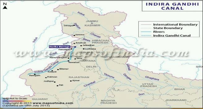
The Indira Gandhi Canal originates near to- a) Chenab and Sutlej Confluence
- b) Chenab and Beas Confluence
- c) Satluj and Beas Confluence
- d) Ravi and Chenab Confluence
Correct answer is option 'C'. Can you explain this answer?
The Indira Gandhi Canal originates near to
a)
Chenab and Sutlej Confluence
b)
Chenab and Beas Confluence
c)
Satluj and Beas Confluence
d)
Ravi and Chenab Confluence
|
|
Sanvi Kapoor answered |
- The Indira Gandhi Canal is one of the largest canal projects in India. It starts from the Harike Barrage at Harike. a few kilometers below the confluence of the Satluj and Beas rivers in the Indian state of Punjab and terminates in irrigation facilities in the Thar Desert in the north west of Rajasthan state. Previously known as the Rajasthan Canal, it was renamed the Indira Gandhi Canal in 1985 following the assassination of Prime Minister Indira Gandhi.
- The canal enters Haryana from Punjab near Lohgarh village then runs through the western part of the Sirsa district before entering Rajasthan near Kharakhera village in the Tibbi tehsil of the Hanumangarh district.
- The canal traverses seven districts of Rajasthan: Barmer, Bikaner, hanumangarh, Jaisalmer, Jodhpur, and Sriganganagar.
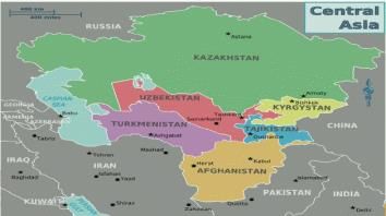
Caspian Sea is surrounded by how many countries?- a) 4
- b) 5
- c) 3
- d) 6
Correct answer is option 'B'. Can you explain this answer?
Caspian Sea is surrounded by how many countries?
a)
4
b)
5
c)
3
d)
6
|
|
Gargi Mukherjee answered |
The Caspian Sea is the largest enclosed inland body of water in the world. It is located between Europe and Asia and is bordered by five countries. The correct answer is option B, i.e., five countries.
Countries bordering the Caspian Sea:
1. Russia: The Caspian Sea's northernmost point touches Russia's southern border.
2. Kazakhstan: The Caspian Sea makes up a significant portion of the country's western border.
3. Turkmenistan: The eastern part of the Caspian Sea borders with Turkmenistan.
4. Iran: The southern part of the Caspian Sea borders with Iran.
5. Azerbaijan: The Caspian Sea makes up a significant portion of Azerbaijan's eastern border.
Hence, the Caspian Sea is surrounded by five countries, making option B the correct answer.
Which of the following are the neighboring countries of Sierra Leo?1. Cote D’ Ivoire2. Guinea3. Liberia4. Senegal- a) 2, 3 only
- b) 3, 4 only
- c) 1, 3, 4 only
- d) 1, 2, 3, 4
Correct answer is option 'A'. Can you explain this answer?
Which of the following are the neighboring countries of Sierra Leo?
1. Cote D’ Ivoire
2. Guinea
3. Liberia
4. Senegal
a)
2, 3 only
b)
3, 4 only
c)
1, 3, 4 only
d)
1, 2, 3, 4
|
|
Devanshi Gupta answered |
Neighboring countries of Sierra Leone
Sierra Leone is a country located in West Africa. It shares its borders with four neighboring countries.
The neighboring countries of Sierra Leone are:
1. Guinea
2. Liberia
Therefore, option A is the correct answer as it includes only the neighboring countries 2 and 3.
Option C includes neighboring country 1, which is incorrect as Sierra Leone does not share a border with Cote D'Ivoire. Option D includes all four neighboring countries, which is also incorrect as Sierra Leone does not share a border with Senegal.
The country of Bhutan is surrounded by- a) China, Nepal, Bangladesh and West Bengal
- b) Nepal, China and India
- c) India, China and Tibet
- d) India and China
Correct answer is option 'D'. Can you explain this answer?
The country of Bhutan is surrounded by
a)
China, Nepal, Bangladesh and West Bengal
b)
Nepal, China and India
c)
India, China and Tibet
d)
India and China
|
|
Rhea Reddy answered |
It is landlocked between Tibet Autonomous Region - north and Indian states of Sikkim, WB, Assam and Arunachal Pradesh.
Which country in Asia continent is known as 'Land of Golden Fibre'?- a) Bangladesh
- b) Indonesia
- c) Malaysia
- d) China
Correct answer is option 'A'. Can you explain this answer?
Which country in Asia continent is known as 'Land of Golden Fibre'?
a)
Bangladesh
b)
Indonesia
c)
Malaysia
d)
China
|
|
Suresh Reddy answered |
Bangladesh is one of the largest jute producing countries in the world. Jute is called the Golden Fibre of Bangladesh.
Consider the following statements:1. This is the national park which was established by Britishers in India.2. The governing body of this national park is Project Tiger.3. Fauna founds includes Tiger, Golden Jackal,Indian Pangolins ,Elephants etc.Choose the correct option - a) Dudhwa National Park
- b) Pilibhit National
- c) Periyar National Park
- d) Corbett National Park
Correct answer is option 'D'. Can you explain this answer?
Consider the following statements:
1. This is the national park which was established by Britishers in India.
2. The governing body of this national park is Project Tiger.
3. Fauna founds includes Tiger, Golden Jackal,Indian Pangolins ,Elephants etc.
Choose the correct option
a)
Dudhwa National Park
b)
Pilibhit National
c)
Periyar National Park
d)
Corbett National Park
|
|
Prashanth Mehta answered |
Explanation:
The correct option is 'D', which is Corbett National Park.
- Corbett National Park was established in 1936 by Britishers in India. It is located in the Nainital district of Uttarakhand, India.
- The governing body of Corbett National Park is Project Tiger, which is a wildlife conservation program launched by the Government of India in 1973 to protect tigers in the country.
- Corbett National Park is home to a wide range of flora and fauna. Some of the animals found in the park include Bengal tigers, Indian elephants, golden jackals, Indian pangolins, and many species of birds and reptiles.
In summary, Corbett National Park is a famous national park in India established by Britishers and governed by Project Tiger. It is home to a diverse range of flora and fauna, including tigers, elephants, and many other animals.
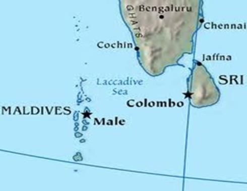
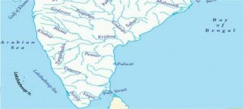
Which among the following is the coastal water body that lies off the Southwest coast of India, north of a line extending from the Southern point of Srijanka to the southernmost of the Maldives Islands and east of the Maldives?- a) Gulf of Mannar
- b) Laccadive sea
- c) Palk Strait
- d) Minicoy
Correct answer is option 'B'. Can you explain this answer?
Which among the following is the coastal water body that lies off the Southwest coast of India, north of a line extending from the Southern point of Srijanka to the southernmost of the Maldives Islands and east of the Maldives?
a)
Gulf of Mannar
b)
Laccadive sea
c)
Palk Strait
d)
Minicoy
|
|
Vijay Kumar answered |
Where is the famous Easter island located?- a) Atlantic ocean
- b) Indian ocean
- c) Arctic ocean
- d) Pacific ocean
Correct answer is option 'D'. Can you explain this answer?
Where is the famous Easter island located?
a)
Atlantic ocean
b)
Indian ocean
c)
Arctic ocean
d)
Pacific ocean

|
Akshara Chavan answered |
Location of Easter Island
Easter Island is located in the Pacific Ocean.
About Easter Island
- Easter Island, also known as Rapa Nui, is a remote island in the southeastern Pacific Ocean.
- It is a special territory of Chile and is famous for its nearly 1,000 monumental statues called Moai.
- The island is located about 2,300 miles from Chile's coast and 2,500 miles west of Tahiti.
Geographical Coordinates
- The geographical coordinates of Easter Island are approximately 27° South latitude and 109° West longitude.
Isolation
- Easter Island is one of the most isolated inhabited islands in the world, with the nearest inhabited land being Pitcairn Island, over 1,200 miles away.
- Its isolation has contributed to its unique culture, history, and archaeological sites.
Cultural Significance
- The Moai statues are one of the most iconic features of Easter Island and are believed to have been created by the island's early inhabitants between 1400 and 1650 AD.
- The island is also known for its vibrant Polynesian culture, traditional dance performances, and annual Tapati Rapa Nui festival.
In conclusion, Easter Island's location in the Pacific Ocean, its isolation, and its cultural significance make it a fascinating destination for tourists and archaeologists alike.
Which strait separates the Gulf of Aqaba from the Red Sea?- a) Strait of Hormuz
- b) Straits of Tiran
- c) Bering Strait
- d) Cook Strait
Correct answer is option 'B'. Can you explain this answer?
Which strait separates the Gulf of Aqaba from the Red Sea?
a)
Strait of Hormuz
b)
Straits of Tiran
c)
Bering Strait
d)
Cook Strait
|
|
Poonam Reddy answered |
It's a narrow passage between Sinai and Arabian peninsulas which separates Gulf of Aqaba from the Red Sea.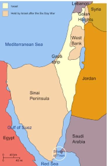
Which are the boundaries shared by the Sea of Azov?1. Ukraine2. Russia 3. Crimean Peninsula4. Turkey- a)1, 2 & 4
- b)1, 2 & 3
- c)3 & 4
- d)all the above
Correct answer is option 'B'. Can you explain this answer?
Which are the boundaries shared by the Sea of Azov?
1. Ukraine
2. Russia
3. Crimean Peninsula
4. Turkey
a)
1, 2 & 4
b)
1, 2 & 3
c)
3 & 4
d)
all the above
|
|
Aashna Singh answered |
Boundaries Shared by the Sea of Azov
The Sea of Azov is bordered by several countries and regions, each sharing different boundaries with this body of water.
- Ukraine
The Sea of Azov shares its boundary with Ukraine to the north and northwest. The northern coast of the sea is primarily Ukrainian territory, with cities like Mariupol and Berdyansk located along the coast.
- Russia
To the east and northeast of the Sea of Azov lies Russia. The Russian Federation has control over the eastern coast of the sea, including the port city of Taganrog. The two countries have had disputes over the control of the sea and its resources.
- Crimean Peninsula
The Crimean Peninsula is located to the south of the Sea of Azov and is currently under Russian control. The peninsula is connected to the mainland by the narrow Kerch Strait, which connects the Sea of Azov to the Black Sea.
Therefore, the boundaries shared by the Sea of Azov include Ukraine, Russia, and the Crimean Peninsula, making option 'B' the correct answer.
Which one of the following pairs of States of India indicates the easternmost and western most State?- a) Assam and Rajasthan
- b) Arunachal Pradesh and Rajasthan
- c) Assam and Gujarat
- d) Arunachal Pradesh and Gujarat
Correct answer is option 'D'. Can you explain this answer?
Which one of the following pairs of States of India indicates the easternmost and western most State?
a)
Assam and Rajasthan
b)
Arunachal Pradesh and Rajasthan
c)
Assam and Gujarat
d)
Arunachal Pradesh and Gujarat
|
|
Palak Pillai answered |
Easternmost and Westernmost States of India
The easternmost and westernmost States of India are Arunachal Pradesh and Gujarat, respectively.
Arunachal Pradesh:
- Arunachal Pradesh is located in the northeastern part of India.
- It shares its borders with Bhutan in the west, China in the north, and Myanmar in the east.
- The state's easternmost point is Kibithu, which is located in the Anjaw district.
Gujarat:
- Gujarat is located in the western part of India.
- It shares its borders with Rajasthan in the north, Maharashtra in the south, and the Arabian Sea in the west.
- The state's westernmost point is the Sir Creek, which is located in the Kutch district.
Conclusion:
In conclusion, Arunachal Pradesh and Gujarat are the easternmost and westernmost States of India, respectively. Arunachal Pradesh's easternmost point is Kibithu, located in the Anjaw district, and Gujarat's westernmost point is the Sir Creek, located in the Kutch district.
Choose the correct match:Dams-Rivers1. Govind Ballabh Pant Sagar- Rihand2. Hirakund -Mahanadi3. Nagarjuna Sagar- Kaveri- a)1, 2 only
- b)2, 3 only
- c)1, 3 only
- d)1, 2, 3
Correct answer is option 'A'. Can you explain this answer?
Choose the correct match:
Dams-Rivers
1. Govind Ballabh Pant Sagar- Rihand
2. Hirakund -Mahanadi
3. Nagarjuna Sagar- Kaveri
a)
1, 2 only
b)
2, 3 only
c)
1, 3 only
d)
1, 2, 3

|
Target Study Academy answered |
- Govind Ballabh Pant Sagar- Rihand
- Hirakund -Mahanadi
- Nagariuna Sagar- Krishna
Which of the given country / ies are land locked?1. South Sudan2. Botswana3. Angola4. GabonQ. Choose the correct option- a)1 only
- b)2, 3 only
- c)1, 2 only
- d)1, 3, 4 only
Correct answer is option 'C'. Can you explain this answer?
Which of the given country / ies are land locked?
1. South Sudan
2. Botswana
3. Angola
4. Gabon
Q. Choose the correct option
a)
1 only
b)
2, 3 only
c)
1, 2 only
d)
1, 3, 4 only
|
|
Sneha Shah answered |
Landlocked countries are those that do not have direct access to the sea. They are completely surrounded by land, making it more challenging for them to engage in international trade and access maritime resources. In this case, South Sudan and Botswana are the only two landlocked countries out of the given options.
South Sudan:
South Sudan is a landlocked country located in East-Central Africa. It gained independence from Sudan in 2011 and is the youngest country in the world. As it does not have any coastline, it is entirely surrounded by six neighboring countries: Sudan to the north, Ethiopia to the east, Kenya to the southeast, Uganda to the south, the Democratic Republic of the Congo to the southwest, and the Central African Republic to the west.
Botswana:
Botswana is a landlocked country located in Southern Africa. It is bordered by four countries: Namibia to the west and north, South Africa to the south, Zimbabwe to the northeast, and Zambia to the north. Despite being landlocked, Botswana has managed to thrive economically due to its rich diamond resources and stable governance.
Angola:
Angola is not a landlocked country. It is located on the west coast of Southern Africa and has a coastline along the Atlantic Ocean. It shares its borders with Namibia to the south, the Democratic Republic of the Congo to the north, and Zambia to the east.
Gabon:
Gabon is also not a landlocked country. It is situated on the west coast of Central Africa and has a coastline along the Atlantic Ocean. It shares its borders with Equatorial Guinea to the northwest and north, Cameroon to the north, and the Republic of the Congo to the east and south.
In conclusion, South Sudan and Botswana are the only landlocked countries among the given options.
Which passage connects southwestern- Atlantic Ocean with south-eastern-Pacific Ocean?- a) Drake Passage
- b) Khardung La Passage
- c) Zoji La Passage
- d) Chanchal Passage
Correct answer is option 'A'. Can you explain this answer?
Which passage connects southwestern- Atlantic Ocean with south-eastern-Pacific Ocean?
a)
Drake Passage
b)
Khardung La Passage
c)
Zoji La Passage
d)
Chanchal Passage
|
|
Nikhil Kapoor answered |
Drake Passage
The Drake Passage is the body of water between the southwestern Atlantic Ocean and the southeastern Pacific Ocean. It connects the southern tip of South America (Cape Horn) with the South Shetland Islands of Antarctica. It is considered one of the roughest and most unpredictable waterways in the world due to strong winds, powerful currents, and rough seas.
Importance of Drake Passage
- The Drake Passage is an important route for marine and air traffic traveling between the Atlantic and Pacific Oceans.
- It is also a significant area for scientific research, particularly in the fields of oceanography, climatology, and marine biology.
Challenges of Crossing Drake Passage
- The strong westerly winds known as the "Roaring Forties" and "Furious Fifties" can create dangerous conditions for ships crossing the Drake Passage.
- The currents in the Drake Passage are some of the strongest in the world, with the Antarctic Circumpolar Current flowing uninterrupted around the continent.
Wildlife in Drake Passage
- Despite its challenges, the Drake Passage is home to a diverse array of marine life, including whales, seals, and seabirds.
- The nutrient-rich waters of the Drake Passage support a thriving ecosystem, making it a popular destination for wildlife enthusiasts and researchers.
In conclusion, the Drake Passage serves as a vital link between the southwestern Atlantic Ocean and the southeastern Pacific Ocean, playing a crucial role in global maritime trade and scientific exploration.
The endangered olive Ridley turtles have the world's largest aggregation at- a) Gahirmatha
- b) Sagarmatha
- c) Lakshadweep Islands
- d) Andaman and Nicobar Islands
Correct answer is option 'A'. Can you explain this answer?
The endangered olive Ridley turtles have the world's largest aggregation at
a)
Gahirmatha
b)
Sagarmatha
c)
Lakshadweep Islands
d)
Andaman and Nicobar Islands
|
|
Keerthana Rane answered |
Explanation:
Gahirmatha:
Gahirmatha beach in Odisha is known to have the world's largest aggregation of endangered olive Ridley turtles. This beach serves as a crucial nesting site for these turtles.
Importance:
The olive Ridley turtles gather in large numbers at Gahirmatha beach every year for mass nesting, known as arribada. This phenomenon is a critical event for the conservation of these turtles.
Conservation Efforts:
Due to the significance of Gahirmatha beach for olive Ridley turtles, conservation efforts have been implemented to protect the nesting site and ensure the safety of the turtles during the nesting season.
Challenges:
Despite conservation measures, these turtles face various threats such as habitat loss, pollution, and accidental capture in fishing nets. Continued efforts are needed to safeguard the population of olive Ridley turtles at Gahirmatha beach.
In conclusion, Gahirmatha beach in Odisha stands out as the world's largest aggregation site for endangered olive Ridley turtles, highlighting the importance of conservation initiatives to protect these marine species.
Which of the following basin is intermountain basin?- a) Qaidam Basin
- b) Tarim Basin
- c) Jubba - Shebelle basin
- d) Rio Grandae
Correct answer is option 'A'. Can you explain this answer?
Which of the following basin is intermountain basin?
a)
Qaidam Basin
b)
Tarim Basin
c)
Jubba - Shebelle basin
d)
Rio Grandae
|
|
Ameya Desai answered |
Introducing Intermountain Basin
The Intermountain Basin is a region characterized by a series of interconnected basins located between the Rocky Mountains and various mountain ranges in the western United States. These basins are known for their unique geographical features and play a significant role in the region's hydrology and ecology.
The Correct Answer: Qaidam Basin
Among the given options, the Qaidam Basin is the correct answer for the Intermountain Basin. Let's explore the characteristics of the Qaidam Basin and understand why it is considered an Intermountain Basin.
1. Qaidam Basin:
The Qaidam Basin is located in western China, specifically in Qinghai province. It is surrounded by mountain ranges, including the Kunlun Mountains to the south, the Qilian Mountains to the northeast, and the Altun Mountains to the northwest. These mountain ranges form a natural boundary around the basin, making it an intermountain basin.
2. Geography and Geology:
The Qaidam Basin spans an area of approximately 120,000 square kilometers, making it one of the largest intermountain basins in the world. It is situated at an average elevation of around 2,800 meters above sea level, making it a high-altitude basin. The basin is primarily composed of sediments deposited over millions of years, resulting in a diverse range of geological formations.
3. Hydrology and Climate:
The Qaidam Basin is a closed basin, meaning it has no outlet for drainage. It is characterized by numerous saline lakes, such as Qinghai Lake, which are fed by rivers and streams flowing from the surrounding mountains. The region experiences a cold desert climate, with low precipitation and extreme temperature variations between day and night.
4. Economic Significance:
The Qaidam Basin is rich in natural resources, including vast reserves of oil, natural gas, and minerals such as salt, potassium, and boron. These resources have played a crucial role in the economic development of the region, with extensive mining and extraction activities taking place in the basin.
Conclusion:
The Qaidam Basin is a prime example of an intermountain basin due to its location between mountain ranges, its closed hydrological system, and its unique geological and ecological characteristics. Understanding the features and significance of the Qaidam Basin helps us identify it as the correct answer among the given options for an intermountain basin.
In which one of the following places is the Shompen tribe found?- a) Nilgiri hills
- b) Nicobar Islands
- c) Spiti valley
- d) Lakshadweep Islands
Correct answer is option 'B'. Can you explain this answer?
In which one of the following places is the Shompen tribe found?
a)
Nilgiri hills
b)
Nicobar Islands
c)
Spiti valley
d)
Lakshadweep Islands
|
|
Anjali Rao answered |
They are the indigenous people of the interior of Great Nicobar island, part of the Indian union territory of Andaman and Nicobar Islands. It is one of the least known particularly vulnerable tribal groups in the A & N islands.
The Wallace's line separates the flora and fauna between- a) Canada and USA
- b) Taiga region and Tundra region
- c) Mexico and Central America
- d) South-East Asia and Australia
Correct answer is option 'D'. Can you explain this answer?
The Wallace's line separates the flora and fauna between
a)
Canada and USA
b)
Taiga region and Tundra region
c)
Mexico and Central America
d)
South-East Asia and Australia
|
|
Prerna Rane answered |
The Wallace's line is an imaginary line that separates the flora and fauna between Southeast Asia and Australia. It was named after the British naturalist, Alfred Russel Wallace, who first identified this distinct boundary in the 19th century. This line is significant because it marks a transition zone where the species distribution changes abruptly.
Geographical Context:
The Wallace's line runs through the Indonesian archipelago, specifically between Bali and Lombok, and then continues northeastwards through the Makassar Strait and Borneo. It extends further east, separating Sulawesi (Celebes) from the Philippines and Halmahera. The line continues southwards, dividing the islands of Timor and Flores, and then reaches the easternmost part of Indonesia.
Reasons for the Separation:
There are several factors that contribute to the separation of flora and fauna across the Wallace's line:
1. Continental Drift: Millions of years ago, the Australian continent was connected to Southeast Asia as part of a supercontinent called Gondwana. Over time, tectonic plates shifted, causing the separation of these landmasses. This resulted in distinct evolutionary paths for the flora and fauna on either side of the Wallace's line.
2. Oceanic Barriers: The deep waters of the Lombok Strait and the Makassar Strait acted as barriers to the dispersal of many species. These narrow and deep channels prevented the movement of land-dwelling animals and restricted the exchange of genetic material between Southeast Asia and Australia.
3. Different Geological History: Southeast Asia has a complex geological history with diverse landforms, such as mountains and plateaus, which have influenced species distribution. On the other hand, Australia has a relatively stable geological history, resulting in unique ecosystems and species adaptations.
Flora and Fauna Distribution:
The Wallace's line serves as a demarcation for distinct biogeographic realms:
1. Sundaland: This realm includes Southeast Asia and is characterized by tropical rainforests, diverse plant species, and a wide range of animal life, including tigers, elephants, and orangutans.
2. Wallacea: This realm lies between the Wallace's line and the Weber Line. It is a transitional zone with a mix of species from both Southeast Asia and Australia. It has a unique combination of flora and fauna, including marsupials, cockatoos, and various reptiles.
3. Australia: This realm is known for its distinctive flora and fauna, including eucalyptus trees, kangaroos, and koalas. It is characterized by arid landscapes, adapted plants, and unique animal adaptations.
Conclusion:
The Wallace's line is a significant natural boundary that separates the flora and fauna of Southeast Asia and Australia. It highlights the impact of geological history and oceanic barriers on species distribution. Understanding the Wallace's line helps scientists study the evolutionary processes and biodiversity of these regions, contributing to our knowledge of biogeography.
Which one of the following pairs of islands is separated from each other by the 'Ten Degree Channel'?- a) Andaman and Nicobar
- b) Nicobar and Sumatra
- c) Maldives and Lakshadweep
- d) Sumatra and Java
Correct answer is option 'A'. Can you explain this answer?
Which one of the following pairs of islands is separated from each other by the 'Ten Degree Channel'?
a)
Andaman and Nicobar
b)
Nicobar and Sumatra
c)
Maldives and Lakshadweep
d)
Sumatra and Java
|
|
Nilesh Mehra answered |
Ten Degree Channel Separates Andaman and Nicobar
Introduction:
The 'Ten Degree Channel' is a water body located in the Bay of Bengal. It separates two prominent islands of India - Andaman and Nicobar.
Explanation:
The Ten Degree Channel is a narrow stretch of water body located between Andaman and Nicobar. It is named so because it lies approximately on the 10th degree of latitude. The channel is about 145 km wide and is considered as one of the most important navigational routes in the region.
Other Options:
Option B - Nicobar and Sumatra are separated by the 'Great Channel'.
Option C - Maldives and Lakshadweep are separated by the 'Eight Degree Channel'.
Option D - Sumatra and Java are separated by the Sunda Strait.
Conclusion:
Hence, the correct answer is option A - Andaman and Nicobar.
Which one of the following can one come across if one travels through the Strait of Malacca:- a) Bali
- b) Brunei
- c) Java
- d) Singapore
Correct answer is option 'D'. Can you explain this answer?
Which one of the following can one come across if one travels through the Strait of Malacca:
a)
Bali
b)
Brunei
c)
Java
d)
Singapore
|
|
Devanshi Gupta answered |
Strait of Malacca is a narrow waterway between the Malay Peninsula and the Indonesian island of Sumatra. It is one of the busiest shipping lanes in the world, connecting the Indian Ocean to the Pacific Ocean. If one travels through the Strait of Malacca, one can come across the following:
1. Singapore: Singapore is a city-state and island country located at the southern end of the Malay Peninsula. It is one of the busiest ports in the world and a major financial hub in Southeast Asia. It is located at the southern entrance of the Strait of Malacca.
2. Malaysia: Malaysia is a country located in Southeast Asia, consisting of two regions separated by the South China Sea. The Malay Peninsula is located to the west of the Strait of Malacca, while the Malaysian state of Sabah is located on the island of Borneo to the east of the strait.
3. Indonesia: Indonesia is an archipelago nation consisting of thousands of islands located to the east of the Strait of Malacca, including the island of Sumatra which the strait borders.
4. Other countries: The Strait of Malacca is an important shipping lane for countries around the world, including China, Japan, South Korea, and Australia. Ships traveling through the strait may be carrying goods such as oil, natural gas, and manufactured goods.
In conclusion, if one travels through the Strait of Malacca, one can come across Singapore, Malaysia, Indonesia, and ships from various countries around the world.
Which of the following states was formed exclusively by the migrants in the 20th century?- a) Maldives
- b) Mauritius
- c) Israel
- d) Myanmar
Correct answer is option 'B'. Can you explain this answer?
Which of the following states was formed exclusively by the migrants in the 20th century?
a)
Maldives
b)
Mauritius
c)
Israel
d)
Myanmar
|
|
Arshiya Gupta answered |
Overview of Mauritius
Mauritius, an island nation in the Indian Ocean, was significantly shaped by migration in the 20th century.
Colonial Background
- The island was initially uninhabited until the Dutch arrived in the 17th century.
- The French and later the British colonized Mauritius, introducing a plantation economy, primarily for sugar production.
20th Century Migration
- The 20th century saw a substantial influx of migrants, especially from India, as indentured laborers.
- The abolition of slavery in 1835 led to the need for labor, and Indians were brought in to work on plantations.
Diverse Population
- This migration created a multicultural society consisting of people from various ethnic backgrounds, including Hindus, Muslims, and Creoles.
- Today, Mauritians celebrate a blend of cultural festivals, reflecting this rich heritage.
Political Independence
- Mauritius gained independence from British rule in 1968, with a population formed largely by migrants.
- The nation has since developed a stable democracy, emphasizing unity in diversity.
Conclusion
- While other options like Israel were formed through specific migrations, Mauritius stands out as a state primarily shaped by 20th-century migrations that led to its unique demographic and cultural identity.
- Therefore, Mauritius is the correct answer as a state formed exclusively by migrants in the 20th century.
Choose the correct relation:1. Baglihar Dam-Jhelum river2. Krishnaganga Dam-Chenab river3. Uri Dam-Jhelum river- a) 2, 3 only
- b) 1 only
- c) 3 only
- d) 1, 2, 3
Correct answer is option 'C'. Can you explain this answer?
Choose the correct relation:
1. Baglihar Dam-Jhelum river
2. Krishnaganga Dam-Chenab river
3. Uri Dam-Jhelum river
a)
2, 3 only
b)
1 only
c)
3 only
d)
1, 2, 3
|
|
Nisha Nair answered |
Relation between Dams and Rivers
Introduction:
Dams play a crucial role in harnessing the potential of rivers for various purposes like irrigation, hydroelectric power generation, and flood control. In this question, we are given three dams and their corresponding rivers. Let's analyze each of them to determine the correct relation.
1. Baglihar Dam - Jhelum River:
The Baglihar Dam is located on the Jhelum River in the Indian-administered union territory of Jammu and Kashmir. It is a run-of-the-river hydroelectric power project designed to utilize the water resources of the Jhelum River for generating electricity. Therefore, the relation between the Baglihar Dam and the Jhelum River is correct.
2. Krishnaganga Dam - Chenab River:
The Krishnaganga Dam is not associated with the Chenab River. The correct dam associated with the Chenab River is the Salal Dam. The Krishnaganga River is a tributary of the Kali River, which is not related to the Chenab River. Hence, the relation between the Krishnaganga Dam and the Chenab River is incorrect.
3. Uri Dam - Jhelum River:
The Uri Dam is located on the Jhelum River in the Indian-administered union territory of Jammu and Kashmir. It is also a run-of-the-river hydroelectric power project that harnesses the water resources of the Jhelum River. Therefore, the relation between the Uri Dam and the Jhelum River is correct.
Conclusion:
Based on the analysis, the correct relation is Option C: 3 only. The Baglihar Dam and Uri Dam are associated with the Jhelum River, while the Krishnaganga Dam is not related to the Chenab River.
Consider the following statements1. The desert is a rain shadow desert formed by Tibetan plateau.2. The desert is a cold desert which extends in two countries.- a) Taklamakan Desert
- b) Gobi Desert
- c) Polond Desert
- d) Gibson Desert
Correct answer is option 'B'. Can you explain this answer?
Consider the following statements
1. The desert is a rain shadow desert formed by Tibetan plateau.
2. The desert is a cold desert which extends in two countries.
a)
Taklamakan Desert
b)
Gobi Desert
c)
Polond Desert
d)
Gibson Desert
|
|
Ujwal Unni answered |
The Gobi Desert in Mongolia and China is in a rain shadow due to the towering Himalaya mountain range. The Atacama Desert in Chile is in a rain shadow created by both the Andes Mountains and weather patterns over the Pacific Ocean.
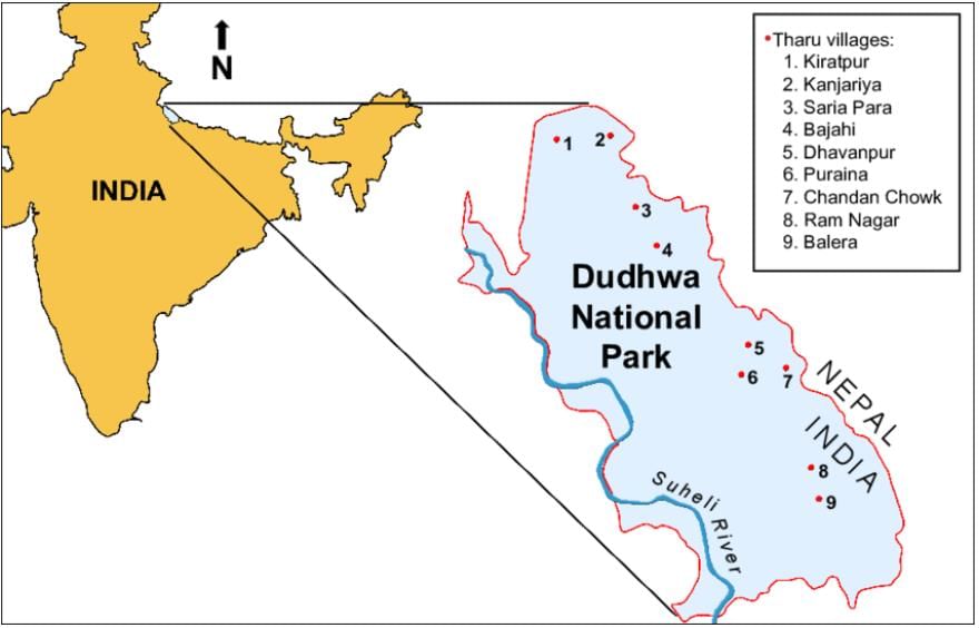
Which of the following National Park is in Uttar Pradesh?- a) Corbett National Park
- b) Dudhwa National Park
- c) Periyar National Park
- d) Manas National Park
Correct answer is option 'B'. Can you explain this answer?
Which of the following National Park is in Uttar Pradesh?
a)
Corbett National Park
b)
Dudhwa National Park
c)
Periyar National Park
d)
Manas National Park
|
|
Kavita Mehta answered |
- The Dudhwa National Park is a national park in the Terai of Uttar Pradesh. India.
- It is part of the Dudhwa Tiger Reserve.
- It is located on the Indo-Nepal border in the Lakhimour Kheri District, and has buffer of reserved forest areas on the northern and southern sides.
- It represents one of the few remaining examples of a highly diverse and productive Terai ecosystem, supporting a large number of endangered species.
- Tributaries of the Ghagra River flow through the park. The water bodies also support a wide variety of wildlife like turtles, crocodiles.
Which Canal connects Pacific Ocean with the Atlantic Ocean?- a) Suez canal
- b) Kiel canal
- c) Panama canal
- d) North-Sea canal
Correct answer is option 'C'. Can you explain this answer?
Which Canal connects Pacific Ocean with the Atlantic Ocean?
a)
Suez canal
b)
Kiel canal
c)
Panama canal
d)
North-Sea canal
|
|
Disha Roy answered |
The Panama Canal
The Panama Canal is a man-made waterway located in Central America that connects the Pacific Ocean to the Atlantic Ocean. It is considered one of the most important engineering feats of the 20th century. The canal was built to provide a shorter route between the two oceans, thereby saving time and money for ships traveling between the Atlantic and Pacific coasts.
Construction of the Canal
The construction of the Panama Canal began in 1904 and was completed in 1914. It was built by the United States government, which took control of the project after the failure of a previous French attempt to build the canal. The construction of the canal was a massive undertaking, involving the excavation of more than 200 million cubic yards of earth and the creation of a system of locks to raise and lower ships between the two oceans.
Operation of the Canal
Today, the Panama Canal is one of the busiest shipping lanes in the world. It is operated by the Panama Canal Authority, a government agency that manages the operation and maintenance of the canal. Ships passing through the canal pay a toll based on their size and the cargo they are carrying.
Benefits of the Canal
The Panama Canal has had a significant impact on global trade and shipping. It has reduced travel time and costs for ships traveling between the Atlantic and Pacific coasts, which has helped to boost international trade. The canal has also had a positive economic impact on the region, creating jobs and attracting investment to Panama.
Conclusion
In summary, the Panama Canal is a vital waterway that connects the Pacific Ocean to the Atlantic Ocean. It was built through a massive engineering project that took over a decade to complete. Today, the canal is a critical component of global trade and shipping, providing a faster and more efficient route for ships traveling between the two oceans.
Consider the following statements:1. Earlier this gulf was popularly known as “Gulf of Berbera2. This waterway is important shipping route between Mediterranean Sea and Arabian Sea.3. This Gulf shares the boundaries with three countries.Q. Choose the correct option:- a) Gulf of Oman
- b) Gulf of Aden
- c) Persian Gulf
- d) None
Correct answer is option 'B'. Can you explain this answer?
Consider the following statements:
1. Earlier this gulf was popularly known as “Gulf of Berbera
2. This waterway is important shipping route between Mediterranean Sea and Arabian Sea.
3. This Gulf shares the boundaries with three countries.
Q. Choose the correct option:
a)
Gulf of Oman
b)
Gulf of Aden
c)
Persian Gulf
d)
None
|
|
Kavita Mehta answered |
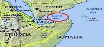
Which mountain pass is present in the tri junction of India-China-Afghanistan border?- a) Mintaka Pass
- b) Parpik Pass
- c) Aghil Pass
- d) Banihal Pass
Correct answer is option 'A'. Can you explain this answer?
Which mountain pass is present in the tri junction of India-China-Afghanistan border?
a)
Mintaka Pass
b)
Parpik Pass
c)
Aghil Pass
d)
Banihal Pass
|
|
Pritam Chaudhary answered |
The correct answer is option 'A', Mintaka Pass.
Mintaka Pass is the mountain pass that is present in the tri junction of India-China-Afghanistan border. It is strategically located in the easternmost part of the Wakhan Corridor, which is a narrow strip of territory in Afghanistan that separates Tajikistan from Pakistan. The pass lies at an elevation of approximately 5,800 meters (19,000 feet) and is one of the highest motorable passes in the world.
Now, let's delve into some key points about Mintaka Pass:
1. Location:
- Mintaka Pass is situated in the Pamir Mountains, which are a part of the greater Himalayas.
- It is located in the northeastern region of Afghanistan, near the border with China and India.
- The pass connects the Wakhan Corridor in Afghanistan with the Taxkorgan Tajik Autonomous County in China's Xinjiang region.
2. Historical Significance:
- Mintaka Pass has been an important trade route for centuries, connecting Central Asia and the Indian subcontinent.
- It was a part of the historic Silk Road, which facilitated the exchange of goods, ideas, and cultures between East and West.
- The pass has witnessed the movement of caravans, traders, and armies throughout history.
3. Strategic Importance:
- Due to its location at the tri junction of India, China, and Afghanistan, Mintaka Pass holds significant strategic value.
- It offers a potential route for trade and connectivity between these three countries and beyond.
- The pass also has military significance, as it allows access to border areas and can serve as a potential corridor for military movements.
4. Challenges and Opportunities:
- The harsh terrain, extreme weather conditions, and high altitude make the crossing of Mintaka Pass challenging.
- However, the pass presents opportunities for economic development and regional integration.
- Efforts have been made to improve infrastructure and connectivity in the region, including the construction of roads and bridges.
In conclusion, Mintaka Pass is the mountain pass present in the tri junction of India-China-Afghanistan border. Its strategic location, historical significance, and potential for trade and connectivity make it an important area of interest for these countries and the wider region.
A particular State in India has the following characteristics:1. It is located on the same latitude which passes through northern Rajasthan.2. It has over 80% of its area under forest cover.3. Over 12% of the forest constitutes the Protected Area Network in this State.Q. Which one among the following States has all the above characteristics?- a) Arunachal Pradesh
- b) Assam
- c) Himachal Pradesh
- d) Uttarakhand
Correct answer is option 'A'. Can you explain this answer?
A particular State in India has the following characteristics:
1. It is located on the same latitude which passes through northern Rajasthan.
2. It has over 80% of its area under forest cover.
3. Over 12% of the forest constitutes the Protected Area Network in this State.
Q. Which one among the following States has all the above characteristics?
a)
Arunachal Pradesh
b)
Assam
c)
Himachal Pradesh
d)
Uttarakhand
|
|
Gayatri Mukherjee answered |
State in India with the given characteristics:
The state in India that has the following characteristics is Arunachal Pradesh.
Characteristics:
1. Same Latitude as Northern Rajasthan: Arunachal Pradesh is located on the same latitude as northern Rajasthan. This means that both states are situated at approximately the same distance from the equator.
2. Over 80% Forest Cover: Arunachal Pradesh is known for its vast forest cover, with over 80% of its area under forests. The state is blessed with a rich biodiversity and is home to numerous endemic species of flora and fauna. The dense forests contribute to the ecological balance and provide a habitat for various wildlife species.
3. 12% Forest Constitutes Protected Area Network: Arunachal Pradesh has taken significant steps towards conserving its natural resources. Over 12% of the state's forest area has been designated as a Protected Area Network. These protected areas include national parks, wildlife sanctuaries, and reserve forests, which are strictly managed and regulated to ensure the conservation of the region's unique biodiversity.
Conclusion:
Based on the given characteristics, Arunachal Pradesh is the only state in India that fulfills all the mentioned criteria. It shares the same latitude as northern Rajasthan, has over 80% forest cover, and has designated over 12% of its forest area as a Protected Area Network.
In how many states Chotanagpur plateau spreads?- a) 4
- b) 3
- c) 6
- d) 5
Correct answer is option 'D'. Can you explain this answer?
In how many states Chotanagpur plateau spreads?
a)
4
b)
3
c)
6
d)
5
|
|
Nabanita Kaur answered |
The Chhota Nagpur Plateau (also referred as Chhota Nagpur) is a plateau in Eastern India, which covers much of Jharkhand state as well as adjacent parts of Orissa, West Bengal, Bihar and Chhattisgarh. The total area of the Chhota Plateau is approximately 65000 square kilometers.
Chapter doubts & questions for Additional Learning Material for Maps - General Awareness for SSC CGL 2025 is part of SSC CGL exam preparation. The chapters have been prepared according to the SSC CGL exam syllabus. The Chapter doubts & questions, notes, tests & MCQs are made for SSC CGL 2025 Exam. Find important definitions, questions, notes, meanings, examples, exercises, MCQs and online tests here.
Chapter doubts & questions of Additional Learning Material for Maps - General Awareness for SSC CGL in English & Hindi are available as part of SSC CGL exam.
Download more important topics, notes, lectures and mock test series for SSC CGL Exam by signing up for free.
General Awareness for SSC CGL
478 videos|1421 docs|396 tests
|
|
© EduRev
|
Education Revolution
|


|


Signup to see your scores
go up
within 7 days!
within 7 days!
Takes less than 10 seconds to signup