


All Exams >
Grade 9 >
Geography for Grade 9 >
All Questions
All questions of India- Size & Location for Grade 9 Exam
Standard meridian of India is __________________.- a)82°50'E
- b)7°30'E
- c)68°7'E
- d)23°30'E
Correct answer is option 'A'. Can you explain this answer?
Standard meridian of India is __________________.
a)
82°50'E
b)
7°30'E
c)
68°7'E
d)
23°30'E
|
|
Gaurav Kumar answered |
The standard meridian of India is 82°30'E. It passes through Mirzapur (Uttar Pradesh). The time of this meridian is taken as the standard time for the whole country.

Which of the following states shares an international boundary? - a)Haryana
- b)Uttar pradesh
- c)Jharkhand
- d)Madhya Pradesh
Correct answer is option 'B'. Can you explain this answer?
Which of the following states shares an international boundary?
a)
Haryana
b)
Uttar pradesh
c)
Jharkhand
d)
Madhya Pradesh
|
|
Amit Sharma answered |
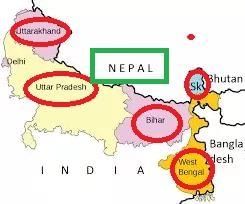
Uttar pradesh shares an international boundary with Nepal.
Which is the southern most point of the Indian Union?- a)Nehru point
- b)Gandhi point
- c)Indira point
- d)None of the above
Correct answer is option 'C'. Can you explain this answer?
Which is the southern most point of the Indian Union?
a)
Nehru point
b)
Gandhi point
c)
Indira point
d)
None of the above
|
|
Krishna Iyer answered |
Indira point is the name of the southernmost point of Republic of India. It is situated on Great Nicobar Island in the Nicobar Islands, which are located in the eastern Indian Ocean at 6°45'10″N and 93°49'36″E. This is not on the Indian mainland, but within the Union Territory of Andaman and Nicobar Islands.
Since the opening of the Suez Canal in 1869, India’s distance from Europe has been reduced by 7000 km.- a)True
- b)False
Correct answer is option 'A'. Can you explain this answer?
Since the opening of the Suez Canal in 1869, India’s distance from Europe has been reduced by 7000 km.
a)
True
b)
False
|
|
Gaurav Kumar answered |
Because, before the opening of Suez Canal, to reach Europe one had to cover almost half the east and whole of west coast of African continent taking a round through the Cape of Good Hope.
In which of the following water bodies are Lakshadweep islands situated?- a)Arabian Sea
- b)Bay of Bengal
- c)Indian Ocean
- d)Atlantic Ocean
Correct answer is option 'A'. Can you explain this answer?
In which of the following water bodies are Lakshadweep islands situated?
a)
Arabian Sea
b)
Bay of Bengal
c)
Indian Ocean
d)
Atlantic Ocean
|
|
Gaurav Kumar answered |
Lakshadweep, formerly the Laccadives, is a group of islands situated some 400 km off India's west coast in the Arabian sea. They are India's only coral atolls and geologically a part of the same chain as the Maldives.
Choose the correctly matched pair.- a) The Suez sea route - Connects Australia and Europe
- b) Indian Ocean - Third-largest ocean in the world
- c) East Africa - East of the Indian subcontinent
- d) Upanishads - Modern Indian literature
Correct answer is option 'B'. Can you explain this answer?
a)
The Suez sea route - Connects Australia and Europe
b)
Indian Ocean - Third-largest ocean in the world
c)
East Africa - East of the Indian subcontinent
d)
Upanishads - Modern Indian literature

|
EduRev Class 9 answered |
- Option A: (a) The Suez sea route - Connects Australia and Europe:
- Explanation: This is incorrect. The Suez sea route provides the shortest route to industrial Europe and America, not specifically connecting Australia and Europe.
- Option B: (b) Indian Ocean - Third-largest ocean in the world
- Correct: The Indian Ocean is indeed the third-largest ocean in the world.
- Option C: (c) East Africa - East of the Indian subcontinent
- Incorrect: East Africa is located to the west of the Indian subcontinent.
- Option D: (d) Upanishads - Modern Indian literature
- Incorrect: The Upanishads are ancient Indian texts that are part of the Vedas, not modern Indian literature. Therefore, the correctly matched pair is Option B: (b).
What geographical features have played a key role in promoting unity and homogeneity in Indian society?- a)Lofty mountains in the north and seas/ocean in the south
- b)Dense forests and vast plains
- c)Arid deserts and deep valleys
- d)Plateaus and river deltas
Correct answer is option 'A'. Can you explain this answer?
What geographical features have played a key role in promoting unity and homogeneity in Indian society?
a)
Lofty mountains in the north and seas/ocean in the south
b)
Dense forests and vast plains
c)
Arid deserts and deep valleys
d)
Plateaus and river deltas
|
|
Eesha Sharma answered |
Geographical Features Promoting Unity in Indian Society
The geographical features of India have significantly influenced its cultural unity and social homogeneity. Among these, the lofty mountains in the north and the seas/ocean in the south play a crucial role.
1. Natural Barriers
- The Himalayas form a natural barrier that protects India from external invasions, fostering a sense of security and stability that allows diverse cultures to flourish in unity.
- This mountain range also influences climate and agriculture, creating a unique environment where various communities can thrive.
2. Coastal Regions
- The extensive coastline of India, bordered by the Indian Ocean, Arabian Sea, and the Bay of Bengal, has facilitated trade and cultural exchange with other nations, promoting a homogeneity of ideas, religions, and practices.
- Coastal communities have historically engaged in maritime trade, leading to the blending of cultures and the spread of languages, arts, and cuisines.
3. Climate and Agriculture
- The geographical features regulate climate patterns, contributing to fertile plains in the north and rich fishing grounds in the south. This agricultural abundance has helped sustain diverse populations and foster unity among them.
4. Shared Resources
- Rivers originating from the Himalayas, such as the Ganges and Yamuna, serve as vital lifelines for millions. These rivers encourage communal activities and shared cultural practices, uniting people across different regions.
In conclusion, the lofty mountains in the north and the seas/ocean in the south have created a conducive environment for cultural exchange, agricultural prosperity, and social cohesion, promoting unity and homogeneity in Indian society.
Choose the correctly matched pair.- a)Tropic of Cancer - 8°04’ N
- b)Latitudinal extent - 68°07’ E to 97°25’ E
- c)Andaman & Nicobar Islands - Bay of Bengal
- d)Total area of India - 9th largest country in the world
Correct answer is option 'C'. Can you explain this answer?
Choose the correctly matched pair.
a)
Tropic of Cancer - 8°04’ N
b)
Latitudinal extent - 68°07’ E to 97°25’ E
c)
Andaman & Nicobar Islands - Bay of Bengal
d)
Total area of India - 9th largest country in the world

|
Kds Coaching answered |
Option A: Tropic of Cancer - 8°04’ N
This is incorrect. The Tropic of Cancer is located at 23°30’ N, not at 8°04’ N. The coordinates 8°04’ N are part of India's southern latitudinal extent.
This is incorrect. The Tropic of Cancer is located at 23°30’ N, not at 8°04’ N. The coordinates 8°04’ N are part of India's southern latitudinal extent.
Option B: Latitudinal extent - 68°07’ E to 97°25’ E
This is incorrect. The given coordinates (68°07’ E to 97°25’ E) represent the longitudinal extent of India, not the latitudinal extent. The correct latitudinal extent of India is 8°04’ N to 37°06’ N.
This is incorrect. The given coordinates (68°07’ E to 97°25’ E) represent the longitudinal extent of India, not the latitudinal extent. The correct latitudinal extent of India is 8°04’ N to 37°06’ N.
Option C: Andaman & Nicobar Islands - Bay of Bengal
This is correct. The Andaman & Nicobar Islands are indeed located in the Bay of Bengal, to the southeast of mainland India.
This is correct. The Andaman & Nicobar Islands are indeed located in the Bay of Bengal, to the southeast of mainland India.
Option D: Total area of India - 9th largest country in the world
This is incorrect. India is the 7th largest country in the world by area, not 9th.
This is incorrect. India is the 7th largest country in the world by area, not 9th.
Therefore, Correct Answer - Option C
Assertion (A): Sri Lanka is separated from India by the Palk Strait.Reason (R): Sri Lanka is located to the south of India.- a)If both Assertion and Reason are true and Reason is the correct explanation of Assertion
- b)If Assertion is true but Reason is false
- c)If both Assertion and Reason are true but Reason is not the correct explanation of Assertion
- d)If both Assertion and Reason are false
Correct answer is option 'C'. Can you explain this answer?
Assertion (A): Sri Lanka is separated from India by the Palk Strait.
Reason (R): Sri Lanka is located to the south of India.
a)
If both Assertion and Reason are true and Reason is the correct explanation of Assertion
b)
If Assertion is true but Reason is false
c)
If both Assertion and Reason are true but Reason is not the correct explanation of Assertion
d)
If both Assertion and Reason are false

|
Imk Pathshala answered |
Let's analyze both statements:
- Assertion (A) is true: Sri Lanka is indeed separated from India by the Palk Strait.
- Reason (R) is also true: Sri Lanka is located to the south of India.
However, the reason that Sri Lanka is located to the south of India is not the explanation for why it is separated from India by the Palk Strait. The Palk Strait is a specific geographical feature that separates the two countries, independent of their relative locations.
Therefore, the correct option is: If both Assertion and Reason are true but Reason is not the correct explanation of Assertion.
What geographical advantage did India's location provide in terms of trade and relations?- a)Proximity to Africa and Australia
- b)Access to the Pacific Ocean
- c)Location at the head of the Indian Ocean
- d)Direct connection to the Atlantic Ocean
Correct answer is option 'C'. Can you explain this answer?
What geographical advantage did India's location provide in terms of trade and relations?
a)
Proximity to Africa and Australia
b)
Access to the Pacific Ocean
c)
Location at the head of the Indian Ocean
d)
Direct connection to the Atlantic Ocean
|
|
Alok Sharma answered |
Geographical Advantage of India's Location
India's strategic position at the head of the Indian Ocean offers significant advantages for trade and international relations.
1. Central Trade Hub
- India is located at the crossroads of major trade routes connecting the East and West.
- The Indian Ocean serves as a vital maritime corridor, facilitating trade with countries in Asia, Africa, and the Middle East.
2. Access to Resources
- Proximity to rich natural resources in neighboring regions enhances trade opportunities.
- Access to vital sea lanes enables India to import essential goods and export its own products efficiently.
3. Maritime Connectivity
- The Indian Ocean connects to several important seas, including the Arabian Sea, Bay of Bengal, and the Andaman Sea.
- This connectivity allows India to engage with various nations, fostering stronger diplomatic and economic ties.
4. Historical Trade Routes
- Historically, India was a key player in ancient trade networks such as the Silk Road and maritime spice routes.
- The legacy of these trade routes continues to influence India's economic partnerships today.
5. Regional Influence
- India’s position enables it to exert influence over neighboring countries and participate actively in regional organizations.
- This geographical advantage enhances India's role in global politics and trade dynamics.
In summary, India's location at the head of the Indian Ocean not only facilitates trade but also strengthens diplomatic relations, making it a pivotal player in international commerce.
Chapter doubts & questions for India- Size & Location - Geography for Grade 9 2025 is part of Grade 9 exam preparation. The chapters have been prepared according to the Grade 9 exam syllabus. The Chapter doubts & questions, notes, tests & MCQs are made for Grade 9 2025 Exam. Find important definitions, questions, notes, meanings, examples, exercises, MCQs and online tests here.
Chapter doubts & questions of India- Size & Location - Geography for Grade 9 in English & Hindi are available as part of Grade 9 exam.
Download more important topics, notes, lectures and mock test series for Grade 9 Exam by signing up for free.
Geography for Grade 9
23 videos|71 docs|28 tests
|
|
© EduRev
|
Education Revolution
|


|


Signup on EduRev and stay on top of your study goals
10M+ students crushing their study goals daily