


All Exams >
Delhi Police Constable >
Lucent for GK >
All Questions
All questions of International Boundaries for Delhi Police Constable Exam
With which country does Nagaland share its international border?- a)Nepal
- b)Myanmar
- c)Bhutan
- d)China
Correct answer is option 'B'. Can you explain this answer?
With which country does Nagaland share its international border?
a)
Nepal
b)
Myanmar
c)
Bhutan
d)
China

|
Knowledge Hub answered |
Nagaland shares its international border with Myanmar.
Myanmar is also called Burma.
In 1989, the name Burma was changed to Myanmar.
Myanmar is also called Burma.
In 1989, the name Burma was changed to Myanmar.

Which of the following countries is a landlocked country?- a)Germany
- b)Italy
- c)Switzerland
- d)France
Correct answer is option 'C'. Can you explain this answer?
Which of the following countries is a landlocked country?
a)
Germany
b)
Italy
c)
Switzerland
d)
France

|
Pritam Shah answered |
Landlocked Country
Landlocked countries are countries that do not have any coastlines and are completely surrounded by other countries. Switzerland is a landlocked country in Europe.
Reason for Switzerland being a landlocked country
- Switzerland is bordered by France to the west, Germany to the north, Austria and Liechtenstein to the east, and Italy to the south.
- It is located in the heart of Europe, with no access to the sea.
- The absence of any coastline makes Switzerland a landlocked country.
Comparison with other options
- Germany has coastlines along the North and Baltic Seas.
- Italy has coastlines along the Mediterranean Sea.
- France has coastlines along the Mediterranean Sea and the Atlantic Ocean.
Therefore, out of the given options, Switzerland is the only landlocked country.
How many Indian states share border with Bhutan?- a)5
- b)3
- c)2
- d)4
Correct answer is option 'D'. Can you explain this answer?
How many Indian states share border with Bhutan?
a)
5
b)
3
c)
2
d)
4
|
|
Ashwin Nambiar answered |
Indian States Sharing Border with Bhutan:
4 States:
- The Indian states that share a border with Bhutan are:
1. Assam
2. Arunachal Pradesh
3. Sikkim
4. West Bengal
Assam:
- Assam shares a 267 km long border with Bhutan. The border is mostly along the foothills of the Himalayas.
Arunachal Pradesh:
- Arunachal Pradesh shares a 217 km long border with Bhutan. The border is located in the western part of the state.
Sikkim:
- Sikkim shares a 220 km long border with Bhutan. The border is mountainous and passes through dense forests and valleys.
West Bengal:
- West Bengal shares a 183 km long border with Bhutan. The border is located in the western part of the state and is mostly hilly terrain.
Conclusion:
- In total, 4 Indian states share a border with Bhutan, namely Assam, Arunachal Pradesh, Sikkim, and West Bengal. These states have diverse landscapes and cultures, making the border regions unique and significant in terms of trade and cultural exchanges.
In which of the following continent are the 6 most populated countries located?- a)Asia
- b)North America
- c)South America
- d)Africa
Correct answer is option 'A'. Can you explain this answer?
In which of the following continent are the 6 most populated countries located?
a)
Asia
b)
North America
c)
South America
d)
Africa
|
|
Knowledge Hub answered |
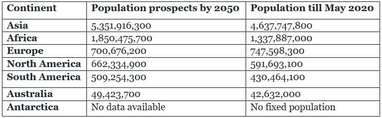
Asia:
- According to population size, the largest Continent is Asia.
- The population of Asia is equivalent to 59.76% of the total world population. It is comprised of the 6 most populated countries.
- The chronology of the Largest content in population size from highest to lowest in Asia, Africa, Europe, North America, South America, Australia, Antarctica.
Which river forms the boundary between Russia and China?- a)Amur river
- b)Yangtze river
- c)Sikiang
- d)Hwang ho
Correct answer is option 'A'. Can you explain this answer?
Which river forms the boundary between Russia and China?
a)
Amur river
b)
Yangtze river
c)
Sikiang
d)
Hwang ho

|
Bank Exams India answered |
Amur River forms the boundary between Russia and China.
Important information's about Asia:
- The Caspian Sea is the world’s largest lake and five times larger than Lake Superior.
- It separates Europe from Asia.
- Dast-e-Kavir is the largest salt desert in the world situated in Northern Iran.
- Lop Nor Lake in China is a site for numerous nuclear tests.
- Hwang Ho is called China’s Sorrow.
- It flows through loess land; hence it is also called as Yellow river.
- Quisling Mountains divide China into North and south China.
- Yangtze River is the longest river in Asia.
- Mekong River flows through China, Thailand-Laos border, Cambodia, and Vietnam to the South China Sea.
- Laos is the only landlocked country in the South-East Asian Peninsula.
- Group of Islands is called an Archipelago.
- Indonesia is the largest Archipelago in the world.
- Irrawaddy River is known as the lifeline of Myanmar.
- It falls into the Gulf of Martaban. In the Gulf of Martaban, pearls are found.
- Lake Van of turkey is the most saline water body of Asia.
- Fujiyama, a volcanic mountain is the highest peak in Japan.
- Japan is the most industrialized nation in Asia.
- Myanmar is called the land of mountains and rivers.
- Pakistan is the country of canals.
- Japan is the land of the Rising Sun.
- The Dead Sea, the third saltiest water body in the world, is a landlocked Sea.
- It lies between Israel and Jordan.
The Sundarbans stretch to which neighbouring country of India?- a)Bangladesh
- b)Pakistan
- c)Nepal
- d)Bhutan
Correct answer is option 'A'. Can you explain this answer?
The Sundarbans stretch to which neighbouring country of India?
a)
Bangladesh
b)
Pakistan
c)
Nepal
d)
Bhutan
|
|
Bank Exams India answered |
The Sundarbans stretch to India's neighbouring country Bangladesh.
- About 60% of the Sundarbans is in Bangladesh and the rest is in India's territory.
- Sundarbans delta is the world's largest delta.
- It was formed by the action of Ganga and the Brahmaputra in the Bay of Bengal.
- The delta is triangular in shape.
- Sundarbans forest is a mangrove area in the delta.
- It extends over a vast area of 9,630 sq. km and consists of mangrove forests, swamps, and forested islands.
- The 'Sundari' is the most significant tree in the Sundarbans forest.
- Sundarbans forest supply timber and forest wood.
- Nepal shares a border with 5 Indian states namely Uttarakhand, Uttar Pradesh, West Bengal, Sikkim, and Bihar.
- Radcliffe Line is the borderline between India and Pakistan.
- In terms of area, Bhutan is the smallest neighbouring country of India.
The Radcliffe line is a boundary between________ and ______ .- a)India and China
- b)India and Bangladesh
- c)India and Sri Lanka
- d)India and Pakistan
Correct answer is option 'D'. Can you explain this answer?
The Radcliffe line is a boundary between________ and ______ .
a)
India and China
b)
India and Bangladesh
c)
India and Sri Lanka
d)
India and Pakistan
|
|
Knowledge Hub answered |
Radcliffe Line" is the boundary line between India and Pakistan.
- Radcliffe Line divided British India into two independent countries India and Pakistan in 1947.
- Radcliffe Line was named after its architect Sir Cyril Radcliffe.
- Three Indian states and one union territory share a boundary with Pakistan.
- Indian states/union territory that share borders with Pakistan are:
- Jammu and Kashmir
- Rajasthan
- Gujarat.
- Punjab.
49th parallel line is a boundary between:- a)India and Pakistan
- b)North Korea and South Korea
- c)USA and Canada
- d)France and Germany
Correct answer is option 'C'. Can you explain this answer?
49th parallel line is a boundary between:
a)
India and Pakistan
b)
North Korea and South Korea
c)
USA and Canada
d)
France and Germany
|
|
Bank Exams India answered |
49th parallel is a boundary between the USA and Canada.
- The 49th parallel lies in the Northern Hemisphere.
- It is a circle of latitude that is 49° north of Earth's equator.
- It was demarcated after the Anglo-American Convention of 1818 and the Oregon Treaty of 1846.
- The line also forms the international border between the northern USA and Canada.
Which of the following States has a boundary with Myanmar as well as Bangladesh?- a)Tripura
- b)Nagaland
- c)Manipur
- d)Mizoram
Correct answer is option 'D'. Can you explain this answer?
Which of the following States has a boundary with Myanmar as well as Bangladesh?
a)
Tripura
b)
Nagaland
c)
Manipur
d)
Mizoram

|
Knowledge Center answered |
Mizoram is a landlocked state in North East India whose southern part shares 722 kilometres long international borders with Myanmar and Bangladesh, and northern part share domestic borders with Manipur, Assam and Tripura.
Which of the following States does not have a boundary with Pakistan?- a)Punjab
- b)Rajasthan
- c)Gujarat
- d)Haryana
Correct answer is option 'D'. Can you explain this answer?
Which of the following States does not have a boundary with Pakistan?
a)
Punjab
b)
Rajasthan
c)
Gujarat
d)
Haryana
|
|
Knowledge Hub answered |
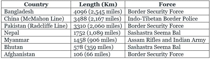
Haryana state does not share its boundary with Pakistan. Seven countries share international borders with India: Bangladesh, China, Pakistan, Afghanistan, Myanmar, Bhutan, and Nepal.
Which line separates the Pakistan and Afghanistan?- a)McMohan Line
- b)Durand Line
- c)Marginal Line
- d)Radcliffe Line
Correct answer is option 'B'. Can you explain this answer?
Which line separates the Pakistan and Afghanistan?
a)
McMohan Line
b)
Durand Line
c)
Marginal Line
d)
Radcliffe Line
|
|
Bank Exams India answered |
Durand Line separates Pakistan and Afghanistan. The Durand Line is the 2,640-kilometer (1,640-mile) international border between Pakistan and Afghanistan, drawn during the British colonial era in 1896 by Sir Mortimer Durand, then Foreign Secretary of British India.
How many countries share land border with INDIA?- a)4
- b)5
- c)7
- d)8
Correct answer is option 'C'. Can you explain this answer?
How many countries share land border with INDIA?
a)
4
b)
5
c)
7
d)
8

|
Capstone Ias Learning answered |
India shares land borders with seven countries.
- Bangladesh
- Bhutan
- China
- Myanmar
- Nepal
- Pakistan
- Afghanistan
Therefore, Correct Answer - Option C
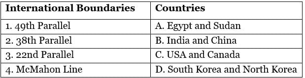
Match the following International boundaries with their countries.
- a)1 - A, 2 - B, 3 - C, 4 -D
- b)1 - C, 2 - D, 3 - A, 4 - B
- c)1 - C, 2 - D, 3 - B, 4 - A
- d)1 - C, 2 - A, 3 - B, 4 - D
Correct answer is option 'B'. Can you explain this answer?
Match the following International boundaries with their countries.
a)
1 - A, 2 - B, 3 - C, 4 -D
b)
1 - C, 2 - D, 3 - A, 4 - B
c)
1 - C, 2 - D, 3 - B, 4 - A
d)
1 - C, 2 - A, 3 - B, 4 - D
|
|
Knowledge Hub answered |
The 49th Parallel is the boundary line that divides the USA and Canada.
- It is located 49 degrees north of the equator.
- It was demarcated after the Anglo-American Convention of 1818 and the Oregon Treaty of 1846, it forms the international border between the northern USA and Canada.
- This line excludes Alaska.
The 38th Parallel is the boundary line that divides South Korea and North Korea.
- It is located 38 degrees north of the equator.
- It is used to demarcate the central part of the Demilitarized zone between North and South Korea.
- The line was chosen by U.S. military planners at the Potsdam Conference (July 1945) near the end of World War II as an army boundary, north of which the U.S.S.R. was to accept the surrender of the Japanese forces in Korea and south of which the Americans were to accept the Japanese surrender.
The 22nd Parallel is the boundary line that divides Egypt and Sudan.
- The 22nd latitude north of the equator marks a major portion of the Sudan-Egypt border.
- In 1899, the Anglo-Egyptian condominium agreement for Sudan set the boundary on the 22nd parallel as the border between the two countries.
McMahon Line is the boundary line that divides India and China.
- This line was determined by Sir Henry McMahon, then Foreign Secretary in the Government of British India.
- It runs from the eastern border of Bhutan along the crest of the Himalayas until it reaches the great bend in the Brahmaputra River where that river emerges from its Tibetan course into the Assam Valley.
What is the boundary line between India and China called?- a)Radcliffe Line
- b)Indira Point
- c)Durand Line
- d)McMahon Line
Correct answer is option 'D'. Can you explain this answer?
What is the boundary line between India and China called?
a)
Radcliffe Line
b)
Indira Point
c)
Durand Line
d)
McMahon Line
|
|
Knowledge Center answered |
McMahon line is between India and China.
- Sir Henry McMahon negotiated the boundary agreement at Shimla Accord in the year 1913-14.
- India shares 2nd longest border with China.
- On the northern front, China claims Aksai Chin in Ladakh UT.
- Uttarakhand, Himachal Pradesh, Arunachal Pradesh, and Sikkim shares a border with China.
- Land borders of India
Which of the following is NOT a landlocked country?- a)Laos
- b)Serbia
- c)Ethiopia
- d)Cambodia
Correct answer is option 'D'. Can you explain this answer?
Which of the following is NOT a landlocked country?
a)
Laos
b)
Serbia
c)
Ethiopia
d)
Cambodia

|
Glance Learning Institute answered |
Laos:
- It is a landlocked nation in Southeast Asia, northeast of Thailand, west of Vietnam.
- It is surrounded by Myanmar (Burma), Cambodia, the People's Republic of China, Thailand, and Vietnam.
Serbia:
- It is a landlocked country situated at the crossroads of Central and Southeast Europe in the southern Pannonian Plain and the central Balkans.
Ethiopia:
- It is a landlocked country on the Horn of Africa.
- It shares borders with Eritrea to the north, Djibouti to the northeast, Somalia to the east, Kenya to the south, South Sudan to the west, and Sudan to the northwest.
Cambodia:
- It is a country in mainland Southeast Asia, bordering Thailand, Laos, Vietnam, the Gulf of Thailand.
- It is not a landlocked country, it shares a border with the Gulf of Thailand.
Important Points
- The largest landlocked country is Kazakhstan in Central Asia with a land area of over 2.7 million kilometers.
- The smallest landlocked country is the city-state of Vatican City with an area of just 44 hectares (109 acres).
Which country shares longest border with India?- a)Pakistan
- b)China
- c)Bangladesh
- d)Nepal
Correct answer is option 'C'. Can you explain this answer?
Which country shares longest border with India?
a)
Pakistan
b)
China
c)
Bangladesh
d)
Nepal
|
|
Knowledge Hub answered |
Bangladesh is a country in South Asia.
- The People's Republic of Bangladesh is the official name of Bangladesh.
- Dhaka is the capital of Bangladesh.
- Bangladesh shares land borders with:
- India to the west, north, and east.
- Myanmar to the southeast.
- Bay of Bengal to the south.
Bangladesh shares the longest border with India. Bangladesh shares a 4,096-kilometre-long (2,545 mi) international border with India. Bangladesh–India border is the fifth-longest land border in the world. Five Indian states that share their border with Bangladesh:
- Assam.
- Tripura.
- Mizoram.
- Meghalaya.
- West Bengal.
How many states of India shared border with Nepal ?- a)3
- b)4
- c)5
- d)6
Correct answer is option 'C'. Can you explain this answer?
How many states of India shared border with Nepal ?
a)
3
b)
4
c)
5
d)
6
|
|
Knowledge Hub answered |
There are five Indian states through which Nepal shares its border. Nepal shares a border of almost 1850 km with Uttar Pradesh, Uttarakhand, Bihar, Sikkim, and West Bengal.
International Boundaries of India:
- After China and Russia, India has the third-largest international border in the whole world.
- India is also called the 'most sensitive border' globally because it varies from infiltration to extreme climatic conditions.
- Its border in the Western part with Pakistan extends up to 3,323 km, dividing the Punjab region.
- After dividing the Punjab region, It running the boundaries up to the Rann of Kutch & Thar Desert in Rajasthan.
- Basically, India claims the entire state of Jammu and Kashmir, which includes China-administered Aksai Chin & Part of Kashmir(Pakistan Administrated).
- According to India, both are illegally occupied areas.
The boundary line between Pakistan and Afghanistan is-- a)McMahon
- b)Radcliffe
- c)Durand
- d)None of the above
Correct answer is option 'C'. Can you explain this answer?
The boundary line between Pakistan and Afghanistan is-
a)
McMahon
b)
Radcliffe
c)
Durand
d)
None of the above
|
|
Knowledge Center answered |
Durand Line is an international land border that stretches for about 1,600 miles (2,600 km) between Afghanistan and Pakistan. It culminates at its western end at the border with Iran and at its eastern end at the border with China. The Durand Line is an important international boundary line.
China does not share its border with- a)Russia
- b)Afganistan
- c)Mongolia
- d)Bulgaria
Correct answer is option 'D'. Can you explain this answer?
China does not share its border with
a)
Russia
b)
Afganistan
c)
Mongolia
d)
Bulgaria
|
|
Glance Learning Institute answered |
China does not share its border with Bulgaria.
- China, officially known as the People's Republic of China, is a country in East Asia.
- It is the world's most populated country, having a population of around 1.4 billion.
- It covers approximately 9.6 million square kilometres.
- China shares its borders with 14 Sovereign Countries.
- They are Afghanistan, Bhutan, India, Kazakhstan, Kyrgyzstan, Laos, Mongolia, Myanmar, Nepal, North Korea, Russia, Tajikistan, and Vietnam.
Which Indian state has longest international border?- a)Gujarat
- b)Rajasthan
- c)Punjab
- d)Jammu and Kashmir
Correct answer is option 'B'. Can you explain this answer?
Which Indian state has longest international border?
a)
Gujarat
b)
Rajasthan
c)
Punjab
d)
Jammu and Kashmir
|
|
Glance Learning Institute answered |
Indo-Pakistan international border in Rajasthan extends about 1070 km and touches the major districts Barmer, Bikaner, Ganganagar and Jaisalmer.
India-Pakistan border is known as :- a)McMohan Line
- b)Durand Line
- c)Rippon Line
- d)Radcliffe Line
Correct answer is option 'D'. Can you explain this answer?
India-Pakistan border is known as :
a)
McMohan Line
b)
Durand Line
c)
Rippon Line
d)
Radcliffe Line
|
|
Knowledge Center answered |
The Radcliffe Line was the boundary demarcation line between the Indian and Pakistani portions of the Punjab and Bengal provinces of British India.
Chapter doubts & questions for International Boundaries - Lucent for GK 2025 is part of Delhi Police Constable exam preparation. The chapters have been prepared according to the Delhi Police Constable exam syllabus. The Chapter doubts & questions, notes, tests & MCQs are made for Delhi Police Constable 2025 Exam. Find important definitions, questions, notes, meanings, examples, exercises, MCQs and online tests here.
Chapter doubts & questions of International Boundaries - Lucent for GK in English & Hindi are available as part of Delhi Police Constable exam.
Download more important topics, notes, lectures and mock test series for Delhi Police Constable Exam by signing up for free.
Lucent for GK
428 videos|766 docs|457 tests
|

Signup to see your scores go up within 7 days!
Study with 1000+ FREE Docs, Videos & Tests
10M+ students study on EduRev
|
© EduRev
|
Education Revolution
|


|


Signup to see your scores
go up within 7 days!
Access 1000+ FREE Docs, Videos and Tests
Takes less than 10 seconds to signup