UPSC Exam  >  UPSC Tests  >  Geography (Prelims) by Valor Academy  >  Test: Physical Geography- 1 - UPSC MCQ

Test: Physical Geography- 1 - UPSC MCQ


Test Description

25 Questions MCQ Test Geography (Prelims) by Valor Academy - Test: Physical Geography- 1

Test: Physical Geography- 1 for UPSC 2025 is part of Geography (Prelims) by Valor Academy preparation. The Test: Physical Geography- 1 questions and answers have been prepared according to the UPSC exam syllabus.The Test: Physical Geography- 1 MCQs are made for UPSC 2025 Exam. Find important definitions, questions, notes, meanings, examples, exercises, MCQs and online tests for Test: Physical Geography- 1 below.
Solutions of Test: Physical Geography- 1 questions in English are available as part of our Geography (Prelims) by Valor Academy for UPSC & Test: Physical Geography- 1 solutions in Hindi for Geography (Prelims) by Valor Academy course. Download more important topics, notes, lectures and mock test series for UPSC Exam by signing up for free. Attempt Test: Physical Geography- 1 | 25 questions in 30 minutes | Mock test for UPSC preparation | Free important questions MCQ to study Geography (Prelims) by Valor Academy for UPSC Exam | Download free PDF with solutions
Test: Physical Geography- 1 - Question 1

Which of the following is NOT a Direct source for obtaining information about the interior of earth?

Detailed Solution for Test: Physical Geography- 1 - Question 1

Meteorites are INDIRECT source of information about the Earth’s Interior.

  • Meteorites and Earth are born from the same nebular cloud. Thus, they are likely to have a similar internal structure.
  • When meteoroids fall to the earth, their outer layer is burnt during their fall due to extreme friction and the inner core is exposed.
  • The heavy material composition of their cores confirms the similar composition of the inner core of the earth. 

But because they are not from inside the earth, they act as an INDIRECT source of information due to similar composition.

Test: Physical Geography- 1 - Question 2

What does 'Roaring forties' refer to?

Detailed Solution for Test: Physical Geography- 1 - Question 2

The Correct Answer is Option C. 

Explanation of the Term 'Roaring Forties'
The term 'Roaring Forties' refers to the geographical region located between the latitudes 40º and 50ºS. This region is well-known for its prevailing westerly winds that blow over the open oceans with great regularity and high intensity. The 'Roaring Forties' have been a critical factor in historical maritime travel, particularly during the Age of Sail.
The main points to understand about the 'Roaring Forties' include:

  • Geographical Location: The 'Roaring Forties' are located in the Southern Hemisphere, specifically between the latitudes 40º and 50ºS. This region is largely composed of open ocean, which allows the winds to gain considerable strength.
  • Wind Patterns: The winds in this region are predominately westerly, meaning they blow from west to east. These winds exhibit a high degree of consistency, both in terms of their direction and their strength.
  • Strength and Regularity: The winds in the 'Roaring Forties' are renowned for their power and regularity. This is primarily due to the absence of large landmasses to disrupt the wind flow, allowing the winds to build up great momentum over the open ocean.
  • Historical Significance: The 'Roaring Forties' played a significant role in historical maritime navigation, particularly during the Age of Sail. Sailors would use these powerful and consistent winds to speed up their voyages, especially when traveling from Europe to the East Indies or Australia.
  • Current Relevance: Today, the 'Roaring Forties' are still important for modern sailing vessels and are also a key factor in global weather patterns. They contribute to the mixing of ocean waters, which affects marine life and global climate.
  • Challenges and Dangers: Despite their utility for maritime travel, the 'Roaring Forties' can also pose significant challenges and dangers. The strong winds can generate large waves and rough sea conditions, making this region potentially hazardous for ships.
Test: Physical Geography- 1 - Question 3

Consider the following statements: 

1. All natural earthquakes take place in the lithosphere.

2. Earthquake waves are basically of three types — body waves, core waves and surface waves. 

Which of the above statement(s) is/ are correct?

Detailed Solution for Test: Physical Geography- 1 - Question 3

Statement 1 is correct: Yes, all natural earthquakes take place in the lithosphere. The lithosphere is the outermost solid layer of the Earth, and includes the Earth's crust and the rigid upper part of the mantle. 
Statement 2 is incorrect: Earthquake waves are basically of two types — body waves and surface waves. Body waves are generated due to the release of energy at the focus and move in all directions travelling through the body of the earth. There is no specific category called "core waves."

Test: Physical Geography- 1 - Question 4

Consider the following statements:

  1. The shadow zone of S-waves is created because they cannot travel through the Earth's liquid outer core.
  2. The Earth's outer core was deduced to be solid due to the behavior of S-waves.
  3. P-waves can be refracted by the liquid outer core, creating a shadow zone.

How many of the statements given above are correct?

Detailed Solution for Test: Physical Geography- 1 - Question 4
  • Statement 1 is correct: S-waves cannot travel through the liquid outer core, creating a shadow zone.
  • Statement 2 is incorrect: The Earth's outer core is liquid, not solid, as deduced by the behavior of S-waves.
  • Statement 3 is correct: P-waves are refracted by the liquid outer core, creating a shadow zone.
Test: Physical Geography- 1 - Question 5

Consider the following statements:

  1. Oceanic crust is primarily composed of basalt.
  2. Continental crust is primarily composed of granite.
  3. Oceanic crust is thicker than continental crust.

How many of the statements given above are correct?

Detailed Solution for Test: Physical Geography- 1 - Question 5
  • ​​​​​​Statement 1 is correct: Oceanic crust is mainly basalt.
  • Statement 2 is correct: Continental crust is mainly granite.
  • Statement 3 is incorrect: Oceanic crust is thinner than continental crust.
     
Test: Physical Geography- 1 - Question 6

Atoll refers to

Detailed Solution for Test: Physical Geography- 1 - Question 6

The Correct Answer is Option D.

  • An atoll sometimes called a coral atoll, is a ring-shaped coral reef including a coral rim that encircles a lagoon partially or completely. There may be coral islands or cays on the rim.
  • The coral of the atoll often sits atop the rim of an extinct seamount or volcano which has eroded or subsided partially beneath the water.
  • The lagoon forms over the volcanic crater or caldera while the higher rim remains above water or at shallow depths that permit the coral to grow and form the reefs.
  • For the atoll to persist, continued erosion or subsidence must be at a rate slow enough to permit reef growth upward and outward to replace the lost height.
Test: Physical Geography- 1 - Question 7

Consider the following statements:

  1. The Earth's lithosphere includes both the crust and the upper mantle.
  2. The asthenosphere is a rigid layer located beneath the lithosphere.
  3. The movement of tectonic plates is driven by convection currents in the mantle.

How many of the statements given above are correct?

Detailed Solution for Test: Physical Geography- 1 - Question 7
  • Statement 1 is correct: The lithosphere includes the crust and the uppermost part of the mantle.
  • Statement 2 is incorrect: The asthenosphere is not rigid; it is a semi-fluid layer beneath the lithosphere.
  • Statement 3 is correct: The movement of tectonic plates is driven by convection currents in the mantle.
Test: Physical Geography- 1 - Question 8

Consider the following statements:

Statement-I: The temperature at the junction of the mantle and outer core is between 2900-3700°C.
Statement-II: The temperature at the junction of the mantle and outer core is primarily a result of internal heat sources, the geothermal gradient, and the high pressure at such great depths.

Which one of the following is correct in respect of the above statements?

Detailed Solution for Test: Physical Geography- 1 - Question 8

- Statement-I is correct: The temperature at the mantle-core boundary, known as the core-mantle boundary (CMB), is estimated to be between 2900-3700°C.
- Statement-II is correct: The temperature at this junction is influenced by internal heat from radioactive decay, the geothermal gradient (increase in temperature with depth), and high pressure conditions.
- Since Statement-II explains why the temperature is within the given range, it serves as a valid explanation for Statement-I.

Thus, the correct answer is A: Both statements are correct, and Statement-II explains Statement-I.

Test: Physical Geography- 1 - Question 9

Consider the following statements:

Statement-I: S-waves cannot travel through the Earth's liquid outer core. Statement-II: This property of S-waves led to the conclusion that the Earth's outer core is liquid.

Which one of the following is correct in respect of the above statements?

Detailed Solution for Test: Physical Geography- 1 - Question 9
  • Statement-I is correct: S-waves cannot travel through the liquid outer core.
  • Statement-II is correct: This inability of S-waves to travel through the outer core led scientists to deduce that it is liquid.
Test: Physical Geography- 1 - Question 10

Consider the following statements:

Statement-I: Continental drift theory was proposed by Alfred Wegener.
Statement-II: The theory suggests that continents move due to forces generated by Earth’s rotation.

Which one of the following is correct in respect of the above statements?

Detailed Solution for Test: Physical Geography- 1 - Question 10

Statement-I: Continental drift theory was proposed by Alfred Wegener.

  • This statement is correct. Alfred Wegener proposed the theory of continental drift in 1912, suggesting that continents were once part of a single landmass called Pangaea and have since drifted apart.

Statement-II: The theory suggests that continents move due to forces generated by Earth’s rotation.

  • This statement is incorrect. While Alfred Wegener did propose that continents drift, he did not attribute their movement to Earth's rotation. Instead, he suggested mechanisms like the gravitational pull of the sun and moon and centrifugal forces, which were later found to be incorrect. The current understanding attributes the movement of continents to plate tectonics and mantle convection rather than Earth's rotation.

Given this analysis: Statement-I is correct but Statement-II is incorrect

Test: Physical Geography- 1 - Question 11

Consider the following statements:

Statement-I: The movement of the Earth's tectonic plates can cause earthquakes.
Statement-II: Tectonic plates move because of convective currents in the mantle.

Which one of the following is correct in respect of the above statements?

Detailed Solution for Test: Physical Geography- 1 - Question 11
  • Statement-I is correct: The movement of tectonic plates can cause earthquakes.
  • Statement-II is correct: Tectonic plates move due to convective currents in the mantle, which explains why their movement causes earthquakes.
Test: Physical Geography- 1 - Question 12

Consider the following statements:

Statement-I: Basalt is the primary rock type found in oceanic crust.
Statement-II: Basalt forms from slow cooling of magma at the surface.

Which one of the following is correct in respect of the above statements?

Detailed Solution for Test: Physical Geography- 1 - Question 12
  • Statement-I is correct: Basalt is indeed the primary rock type found in oceanic crust.
  • Statement-II is incorrect: Basalt forms from rapid cooling of magma at the surface, not slow cooling.
Test: Physical Geography- 1 - Question 13

Select the correct option from the given alternatives.

Statement (a) - The shape of Indian Ocean is S
Statement (b) - The S shape of Indian Ocean provides an ideal location for natural harbours 

Detailed Solution for Test: Physical Geography- 1 - Question 13

The Indian Ocean is the third-largest of the world's five oceanic divisions, covering 70,560,000 km2 (27,240,000 sq mi) or 19.8% of the water on Earth's surface.

Test: Physical Geography- 1 - Question 14

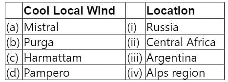
Match the following :

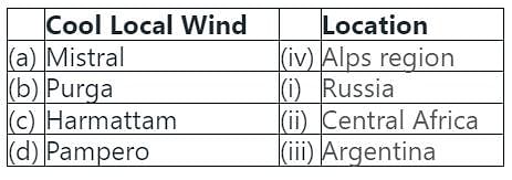
Detailed Solution for Test: Physical Geography- 1 - Question 14

The correct pair is (a) - (iv), (b) - (i), (c) - (ii), (d) - (iii)

Test: Physical Geography- 1 - Question 15

Which one of the following is the dominant element of the Earth's crust?

Detailed Solution for Test: Physical Geography- 1 - Question 15

The correct answer is Oxygen.

Test: Physical Geography- 1 - Question 16

In which one of the following cities the mountains of sand called “Sand Dunes” are found?

Detailed Solution for Test: Physical Geography- 1 - Question 16
  • The city of Abu Dhabi offers various adventurous activities for tourist attraction and one of such activities is Sand dune riding or Sand dune Safari
  • Abu Dhabi is the capital of the United Arab Emirates.

Thus, Sand Dunes are found in Abu Dhabi.

Test: Physical Geography- 1 - Question 17

The Andaman islands were hit by a tsunami in the year

Detailed Solution for Test: Physical Geography- 1 - Question 17

A tsunami is a series of waves caused by earthquakes or undersea volcanic eruptions. 

Test: Physical Geography- 1 - Question 18

Lines joining places of equal rainfall are known as

Detailed Solution for Test: Physical Geography- 1 - Question 18

The Correct Answer is Option D

  • Definition: Isohyets are lines drawn on a map that connect points that receive the same amount of precipitation within a certain period. They are commonly used in meteorology and hydrology to give a graphical representation of rainfall distribution across a specific area.
  • Usage:- These lines are highly useful for various purposes, such as agriculture, flood prediction, and water resource management. They help in understanding the rainfall pattern, which can aid in planning agricultural activities.
  • Creation of Isohyets:-To create isohyets, meteorologists use data from weather stations about the amount of rainfall. They then draw lines on a map connecting places with the same rainfall amount.
  • Understanding the Map:- On an isohyetal map, the areas between the lines indicate zones where the rainfall is within the range of the two bounding isohyets. The closer the lines, the steeper the gradient of rainfall, which means a rapid change in the amount of rainfall over a short distance.
  • Comparison with other Iso lines:- Isohyets are similar to other geographical lines such as isotherms (lines of equal temperature), isobars (lines of equal pressure), and isohalines (lines of equal salinity). Each of these lines helps to represent different types of data on a map.
  • Limitations:- Despite their usefulness, isohyets also have limitations. They are based on data from weather stations, which may not be evenly distributed. Therefore, in areas with fewer weather stations, the rainfall data could be less accurate.
Test: Physical Geography- 1 - Question 19

Piecing together the puzzle of geologic time to create and analyze historical maps of the Earth is known as

Detailed Solution for Test: Physical Geography- 1 - Question 19
  • Paleogeography is the ancient geography of Earth’s surface.
  • Earth’s geography is constantly changing and these geographic changes can be traced through the study of the rock and the fossil record, and data can be used to create paleogeographic maps, which illustrate how the continents have moved and how the past locations of mountains, lowlands, shallow seas, and deep ocean basins have changed.
  • The study of paleogeography has two principal goals:
    • The first is to map the past positions of the continents and ocean basins
    • The second is to illustrate Earth’s changing geographic features through time.
Test: Physical Geography- 1 - Question 20

Select the correct statements about Abu Dhabi:

A. It is located in a desert area.
B. Water is costlier than petrol in Abu Dhabi.
C. Arabic is the local language here.
D. Money used in Abu Dhabi is called Dinar.

Detailed Solution for Test: Physical Geography- 1 - Question 20
  • Abu Dhabi is the capital of the United Arab Emirates.
  • It is found in the western part of Asia
  • It is located in a desert area and has very little water
  • The weather is very hot.
  • People wear loose cotton clothes and keep themselves fully covered to protect themselves from the strong sun
  • Petrol is present in abundant quantities in Abu Dhabi and forms a major part of its exports
  • Thus, water is costly than petrol in the region
  • The currency of Abu Dhabi is Dirham
  • The people of Abu Dhabi speak the Arabic language
  • The date is the most common fruit of the region as very little plantation can be done in the desert
Test: Physical Geography- 1 - Question 21

Which earthquake measuring scale is based on Earth’s rigidity and the amount and area of slip on the fault?

Detailed Solution for Test: Physical Geography- 1 - Question 21

The correct answer is the Moment magnitude scale.

An earthquake is the sudden release of strain energy in the Earth’s crust resulting in waves of shaking that radiate outwards from the earthquake source. An earthquake is the result of plate tectonic activities.

Test: Physical Geography- 1 - Question 22

The direction of wind around a low pressure in northern hemisphere is:

Detailed Solution for Test: Physical Geography- 1 - Question 22

The Correct Answer is OptionC
The direction of wind around a low pressure system in the Northern Hemisphere is primarily influenced by two forces: the pressure gradient force and the Coriolis effect.

  • Pressure Gradient Force: This force results from the difference in atmospheric pressure from one location to another. It directs the wind to flow from high pressure areas to low pressure areas. This would typically result in winds flowing directly into the low pressure center.
  • Coriolis Effect: The Coriolis effect is a deflective force that arises due to earth's rotation. In the Northern Hemisphere, it deflects the wind to the right of its path. So, instead of winds flowing directly into the low pressure center, they are deflected to the right, resulting in a counter-clockwise circulation around the low pressure

Therefore, the combination of these two forces causes the wind to flow counter-clockwise around a low pressure system in the Northern Hemisphere. This is why option C is the correct answer.

Test: Physical Geography- 1 - Question 23

Consider the following statements about Jet Stream circulations choose the correct ones:
1. Jet stream is a current of fast moving air found in the upper levels of the atmosphere somewhere between 10-15 km above the earth’s surface
2. The position of jet stream denotes the location of the strongest surface temperature contrast.
3. Winds of jet stream are stronger in summer than winter.
4. Jet streams generally blow from west to east.

Choose the correct answer

Detailed Solution for Test: Physical Geography- 1 - Question 23

The Correct Answer is Option C.
Jet Stream Circulations:

  • Jet stream is indeed a current of fast moving air found in the upper levels of the atmosphere, typically between 10 to 15 kilometers above the Earth’s surface. This is due to the fact that these altitudes are where the temperature gradients, or changes, are the strongest.
  • The position of the jet stream often coincides with the location of the strongest surface temperature contrast. This is because the jet stream is driven by these temperature contrasts, and its position can shift as these contrasts change. For example, during the winter, when the temperature contrast between the equator and the poles is the greatest, the jet stream is often found at lower latitudes.
  • Winds of the jet stream are generally stronger in the winter than in the summer. This is because the temperature contrast between the equator and the poles is greater in the winter, producing stronger winds. Therefore, statement 3 is incorrect.
  • Jet streams do generally blow from west to east. This is due to the rotation of the Earth, which creates a force (the Coriolis effect) that deflects the path of the winds to the east.

Therefore, statements 1, 2, and 4 are correct. Hence, the correct answer is C: Only 1, 2 and 4.

Test: Physical Geography- 1 - Question 24

A meridian is

Detailed Solution for Test: Physical Geography- 1 - Question 24

The Correct Answer is Option A.

Understanding a Meridian
A meridian, in geography, is an imaginary line that runs from the North Pole to the South Pole of the Earth. These lines are used in cartography and navigation to specify the east-west position of a point on the Earth's surface.

  • Definition: A meridian is defined as the circle of the Earth that passes through the North and South Poles and any given point on the Earth's surface. This is the first option (A) in your question.
  • Longitude: Meridians are often associated with lines of longitude, which are the angles east or west from a reference meridian, usually the Prime Meridian, which runs through Greenwich, London, UK. Every place on Earth has a unique longitude that can be measured in degrees, minutes, and seconds.
  • Significance: Meridians, along with parallels (lines of latitude), create a grid system known as the graticule. This system allows for precise location of any place on Earth through the use of coordinates.

Other Options Explained

  • The Distance Between the Earth and the Moon: This is not related to the concept of a meridian. This distance varies slightly due to the elliptical shape of the Moon's orbit, but the average is about 238,855 miles (384,400 kilometers).
  • The Axis Around Circle of the Earth Away from the Equator Towards the Poles: This seems to refer to the Earth's axis of rotation, which is an imaginary line running from the North Pole to the South Pole, around which the Earth rotates. However, this is not what is meant by a meridian.
  • The Latitudinal Circle of the Earth Away from the Equator Towards the Poles: This might be referring to lines of latitude, also known as parallels, which run east-west around the Earth. These lines are not meridians, but they do intersect with meridians at right angles to create the graticule. The equator is the largest and most significant of these lines, representing 0 degrees latitude.
Test: Physical Geography- 1 - Question 25

Excluding the moon, the celestial object that generally appears bright in the sky is

Detailed Solution for Test: Physical Geography- 1 - Question 25

The Correct Answer is Option D

Brightness of Venus

  • Venus is referred to as both the "morning star" and the "evening star" because it is often the brightest object in the sky (excluding the moon).
  • The brightness of Venus is due to its proximity to Earth and its highly reflective clouds. It is the second planet from the sun and is closest to Earth compared to any other planet.
  • Venus has an albedo, or reflectivity, of about 0.7. This means it reflects 70% of the sunlight that falls on it, making it extremely bright.


Jupiter's Brightness

  • Jupiter, while often visible to the naked eye and quite bright, is not as consistently bright as Venus.
  • Jupiter's brightness can vary depending on its position in relation to Earth and the Sun.
  • Although Jupiter is a much larger planet than Venus, it is much further away from Earth.

Polestar's Brightness

  • The Polestar, also known as Polaris, is famous not for its brightness but for its position in the sky. It's located nearly directly above the Earth's North Pole.
  • Polaris is not particularly bright compared to other stars. Its importance comes from its consistent position, which makes it useful for navigation.


Sirius' Brightness

  • Sirius is the brightest star in the Earth's night sky. However, it is not as bright as Venus.
  • Its brightness is because it is relatively close to the Earth and it is a highly luminous star.


Conclusion
When comparing the brightness of these celestial bodies from Earth's perspective, Venus typically appears the brightest, followed by Sirius, then Jupiter, and lastly, the Polestar. Therefore, the correct answer, excluding the moon, is Venus.

47 videos|183 docs|155 tests
Information about Test: Physical Geography- 1 Page
In this test you can find the Exam questions for Test: Physical Geography- 1 solved & explained in the simplest way possible. Besides giving Questions and answers for Test: Physical Geography- 1, EduRev gives you an ample number of Online tests for practice
Download as PDF