Class 6 Exam  >  Class 6 Tests  >  Social Studies (SST) Class 6  >  Important Questions Test: Globe Latitudes And Longitudes - Class 6 MCQ

Important Questions Test: Globe Latitudes And Longitudes - Class 6 MCQ


Test Description

15 Questions MCQ Test Social Studies (SST) Class 6 - Important Questions Test: Globe Latitudes And Longitudes

Important Questions Test: Globe Latitudes And Longitudes for Class 6 2024 is part of Social Studies (SST) Class 6 preparation. The Important Questions Test: Globe Latitudes And Longitudes questions and answers have been prepared according to the Class 6 exam syllabus.The Important Questions Test: Globe Latitudes And Longitudes MCQs are made for Class 6 2024 Exam. Find important definitions, questions, notes, meanings, examples, exercises, MCQs and online tests for Important Questions Test: Globe Latitudes And Longitudes below.
Solutions of Important Questions Test: Globe Latitudes And Longitudes questions in English are available as part of our Social Studies (SST) Class 6 for Class 6 & Important Questions Test: Globe Latitudes And Longitudes solutions in Hindi for Social Studies (SST) Class 6 course. Download more important topics, notes, lectures and mock test series for Class 6 Exam by signing up for free. Attempt Important Questions Test: Globe Latitudes And Longitudes | 15 questions in 20 minutes | Mock test for Class 6 preparation | Free important questions MCQ to study Social Studies (SST) Class 6 for Class 6 Exam | Download free PDF with solutions
Important Questions Test: Globe Latitudes And Longitudes - Question 1

Equator is an

Detailed Solution for Important Questions Test: Globe Latitudes And Longitudes - Question 1

The Equator is an imaginary line around the middle of the Earth. It is halfway between the North and South Poles, and divides the Earth into the Northern and Southern Hemispheres. The Equator is the invisible line that runs around the center of the Earth at 0 degrees latitude.

Important Questions Test: Globe Latitudes And Longitudes - Question 2

The 0 degree Meridian is also known as

Detailed Solution for Important Questions Test: Globe Latitudes And Longitudes - Question 2

This is why prime meridian is also known as the Greenwich Meridian. In a geographical coordinate system, the Greenwich Meridian (or prime meridian) is the 0o line of longitude from which we measure 180o to the west and 180o to the east. Most coordinate systems define a zero line at the equator that runs east-west.

1 Crore+ students have signed up on EduRev. Have you? Download the App
Important Questions Test: Globe Latitudes And Longitudes - Question 3

The distance between the longitude

Detailed Solution for Important Questions Test: Globe Latitudes And Longitudes - Question 3

Angular distance of any place from the prime meridian(that is 0o also known as Greenwich Line), on its East or West, is known as Longitude. The distance between two adjacent longitudes is maximum at Equator that is 111.32 km, which keeps on decreasing towards the poles because longitudes taper towards the poles.

Important Questions Test: Globe Latitudes And Longitudes - Question 4

In the globe, Two end point of the axis are called

Detailed Solution for Important Questions Test: Globe Latitudes And Longitudes - Question 4

The two end points on the axis of rotation are called the poles. To the north is the North Pole, and to the south is the South Pole.

Important Questions Test: Globe Latitudes And Longitudes - Question 5

The Arctic Circle is located in the

Detailed Solution for Important Questions Test: Globe Latitudes And Longitudes - Question 5

The Arctic Circle is a region on Earth that is marked as one of the five major circles of latitude on maps of our planet. It is located between the Arctic to its north and the Northern Temperate Zone to its south. Its counterpart in the Southern Hemisphere is known as the Antarctic Circle.

Important Questions Test: Globe Latitudes And Longitudes - Question 6

______ measure the distance north and south of the Equator

Detailed Solution for Important Questions Test: Globe Latitudes And Longitudes - Question 6

Latitude measures the distance north or south of the equator. Lines of latitude, also called parallels, are imaginary lines that divide the Earth.

Important Questions Test: Globe Latitudes And Longitudes - Question 7

The line which cut the world into north and south latitude

Detailed Solution for Important Questions Test: Globe Latitudes And Longitudes - Question 7

Latitude is based on an imaginary line that circles Earth halfway between the north and south poles. This line is called Equator and it divides Earth into northern and southern hemispheres. A hemisphere is one half of a sphere. is a distance in degrees north or south of the Equator, which is 0°.

Important Questions Test: Globe Latitudes And Longitudes - Question 8

This marks the location of the equator on Earth

Detailed Solution for Important Questions Test: Globe Latitudes And Longitudes - Question 8

The equator divides the earth into the Northern Hemisphere and the Southern Hemisphere is marks the location of 0 degrees latitude. The equator marks the locations on earth that are equidistance from the North and South Poles. The Equator crosses 78.7% water and 21.3% land and is about 24,901 miles (40,075 km) long.

Important Questions Test: Globe Latitudes And Longitudes - Question 9

Why are the regions called Frigid Zones very cold?

Detailed Solution for Important Questions Test: Globe Latitudes And Longitudes - Question 9
  • The regions known as Frigid Zones are positioned far from the equator.
  • Here, the sun's rays strike the Earth at a slant, which means they spread out over a larger area and provide less warmth.
  • These areas experience long periods of low sunlight, especially during winter, contributing to their cold climate.
  • Though they may have snow and ice, the primary reason for the cold is the angle of the sun’s rays.
Important Questions Test: Globe Latitudes And Longitudes - Question 10

What are latitude and longitude lines?

Detailed Solution for Important Questions Test: Globe Latitudes And Longitudes - Question 10

Latitude and longitude lines form an imaginary grid over the entire surface of Earth. Latitude is based on an imaginary line that circles Earth halfway between the north and south poles. This line is called the equator and it divides Earth into northern and southern hemispheres. Latitude is a distance in degrees north or south of the equator. Longitude is a distance in degrees east or west of the Prime Meridian.

Important Questions Test: Globe Latitudes And Longitudes - Question 11

Days and nights are equal throughout the globe when the sun is above:

Detailed Solution for Important Questions Test: Globe Latitudes And Longitudes - Question 11

The event known as Equinox, is eagerly awaited by space enthusiasts as it take place twice a year on 21st March and 23rd September. On the Equinox day, the sun move across the celestial equator, which lie directly above the Earth's equator.

Important Questions Test: Globe Latitudes And Longitudes - Question 12

Describe the shape of the Earth?

Detailed Solution for Important Questions Test: Globe Latitudes And Longitudes - Question 12


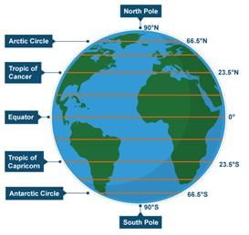
Fig: Shape of the Earth

Important Questions Test: Globe Latitudes And Longitudes - Question 13

Identify the red line in the picture. Options are as follows 


Detailed Solution for Important Questions Test: Globe Latitudes And Longitudes - Question 13

Vertical lines on the globe are Known as longitudes. But zero degree longitude is called as prime meridian. Prime meridian is also a longitude. Here, 0 degree prime meridian is shown only as an example. Prime meridian is also known as longitude but vice versa of it is not possible. For example, Prime meridian is always a longitude but every longitude is not prime meridian. In this picture all longitudes are shown.
So, the correct answer is Option C.

Important Questions Test: Globe Latitudes And Longitudes - Question 14

IST stands for

Detailed Solution for Important Questions Test: Globe Latitudes And Longitudes - Question 14

Indian Standard Time (IST) is the time observed throughout India, with a time offset of UTC+05:30. India does not observe daylight saving time (DST) or other seasonal adjustments. In military and aviation time IST is designated E* ("Echo-Star").

Important Questions Test: Globe Latitudes And Longitudes - Question 15

The Northernmost end of the axis is ______

Detailed Solution for Important Questions Test: Globe Latitudes And Longitudes - Question 15

The Northern tip and the Southern tip of the axis are called the North Pole and the South Pole. The Earth rotates or spins on its axis. The axis is an imaginary straight line which passes through the North Pole, the centre of the Earth and the South Pole. The Earth's axial tilt is about 23.5 degrees.

67 videos|386 docs|80 tests
Information about Important Questions Test: Globe Latitudes And Longitudes Page
In this test you can find the Exam questions for Important Questions Test: Globe Latitudes And Longitudes solved & explained in the simplest way possible. Besides giving Questions and answers for Important Questions Test: Globe Latitudes And Longitudes, EduRev gives you an ample number of Online tests for practice

Top Courses for Class 6

67 videos|386 docs|80 tests
Download as PDF

Top Courses for Class 6