Precambrian rocks in India are mostly found in the
The Precambrian rocks of India are categorized into two systems and they are as follows:
(i) The Archean System and The Dharwar System.
(ii) The stones of the Dharwar System are mostly sedimentary rocks. They are typically found in Mysore and Bellary in Karnataka and Aravalli Mountain Range, Rajputana, Rajasthan.
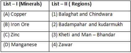
Match List-I with List-II and select the correct answer.
Codes
1. Moist deciduous forests are found throughout India except in the western and the north-western regions. The trees have broad trunks, are tall and have branching trunks and roots to hold them firmly to the ground. Some of the taller trees shed their leaves in the dry season. There is a layer of shorter trees and evergreen shrubs in the undergrowth. These forests are dominated by sal and teak, along with mango, bamboo, and rosewood.
2. Dry deciduous forests are found throughout the northern part of the country except in the North-East. It is also found in Madhya Pradesh, Gujarat, Andhra Pradesh, Karnataka, and Tamil Nadu. The canopy of the trees does not normally exceed 25 metres. The common trees are the sal, a variety of acacia, and bamboo.
3. Littoral and swamp forests are found along the Andaman and Nicobar Islands and the delta area of the Ganga and the Brahmaputra. It consists mainly of whistling pines, mangrove dates, Sundari, palms, and bulletwood. They have roots that consist of soft tissue so that the plant can breathe in the water.
4. Sub alpine forests extends from Kashmir to Arunachal Pradesh between 2900 to 3500 metres. In the Western Himalayas, the vegetation consists mainly of juniper, rhododendron, willow, and black currant. In the eastern parts, red fir, black juniper, birch, and larch are the common trees. Due to heavy rainfall and high humidity the timberline in this part is higher than that in the West. Rhododendron of many species covers the hills in these parts.
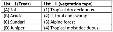
Match the following pairs.
Select the answer using the codes given below :
Codes
(a) Khetri Nagar, well known for its Copper Project, was built by and is under the control of Hindustan Copper Limited, a public sector undertaking under the Government of India. Khetri Nagar is also very well known with name of 'Copper'.
(b) The Iron ore deposits are found in Badampahar mines of Odisha and Kudremukh deposits of Karnataka. In Badampahar high grade hematite ores are found.
(c) Zawar (Rajasthan) is famous for zinc mines. Zawar is a township created by mining company Hindustan Zinc Limited, for extraction of zinc and lead. An 80MW power plant provides electricity for mining zinc and lead from three major mines.
(d) The "Bharveli manganese mine" in Balaghat district is largest underground mine operating in Asian subcontinent. The manganese ore deposits of the State are being exploited mainly by the Manganese Ore India Limited.
With reference to El Nino, consider the following statements;
1. Apart from large-scale climatic aberrations in the Tropics, El Nino has a disastrous consequence on the fishing industry of Peru.
2. El Nino leads to massive displacements of the rainfall bringing droughts over large parts of the normal raining areas and torrential rains to arid regions of the Tropics.
Which of the above statements is/are correct?
With reference to Tundra region, consider the following statements;
1. The Tundra environment is characterized by a few important climatic and environmental elements.
2. The Tundra biomes are found in Arctic or Alpine regions.
Which of the above statements is/are correct?
Tundra, a major zone of treeless level or rolling ground found in cold regions, mostly north of the Arctic Circle (Arctic tundra) or above the timberline on high mountains (alpine tundra). Tundra is known for large stretches of bare ground and rock and for patchy mantles of low vegetation such as mosses, lichens, herbs, and small shrubs. This surface supports a meagre but unique variety of animals. The Finns called their treeless northern reaches the tunturi, but the concept of a vast frozen plain as a special ecological realm called tundra was developed by the Russians.
With reference to the economy of New Zealand, consider the following statements:
1. Butter, wool and frozen meat are the most important exports of New Zealand.
2. New Zealand has cool moist climate and vast grasslands to support livestock.
Which of the above statements is/are correct?
Milk powder, butter, and cheese are New Zealand's largest exports, followed by meat and edible offal. Australia is the largest market for exports, with almost a quarter of total exports and over twice the value of exports as China – New Zealand's second-largest market.
Consider the following statements;
1. Eight degree channel separates Minicoy Island (India) from Maldives
2. Nine degree channel separates Kavaratti from Minicoy Island.
3. Duncan Passage lies between South Andaman and Little Andaman.
Which of the above statements is/are correct?
Which of the following pairs of National Water Ways of India is incorrect?
Which of the following Railway Zone and its Headquarters is wrongly matched?
The Northern Railway Zone operates the Amritsar Junction Railway Station headquartered at Jaipur.
Consider the following statements about Geographical Information Systems (GIS)
1. It handles attribute data on a technical base
2. It can draw maps and other graphics with great ease and speed
3. It is a slow and tedious task involving creation of GIS data base
4. It works only in combination with remote sensing data.
5. It can analyse data for specified task and thus help decision making
Which of the above statements is/are correct?
A geographic information system (GIS) is a system designed to capture, store, manipulate, analyze, manage, and present all types of geographical data. Coupled with this data is usually tabular data known as attribute data. Attribute data can be generally defined as additional information about each of the spatial features GIS is more than just software. People and methods are combined with geospatial software and tools, to enable spatial analysis, manage large datasets, and display information in a map/graphical form.
With reference to weathering, consider the following statements:
1. Weathering encompasses a group of processes by which surface and subsurface rocks disintegrate
2. Extreme dryness reduces most weathering to a minimum
3. Physical weathering dominates in drier and cooler climates
4. In equatorial rain-forest climate, most rocks weather slowly
Which of the above statements is/are correct?
Although the rate of weathering depends on the type of rock, rocks in tropical climates experience the highest rates of weathering because of the combination of high heat and heavy rainfall.
Consider the following pairs of tiger reserves and states
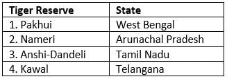
Which of the pairs given above is/are correctly matched?
Which one of the following countries of South - West Asia does not open out to the Mediterranean sea?
In the South Atlantic and south - eastern pacific regions in tropical latitudes, cyclones does not originate. What is the reason?
Despite the seasonal shift of ITCZ, it is seen that ITCZ seldomly shift south of the Equator to tropical areas in southern Hemisphere, due to which Coriolis force is not generated for a cyclone.
Tides occur in the oceans and seas due to which among the following?
1. Gravitational force of the Sun
2. Gravitational force of the Moon
3. Gravitational force of the Earth
Select the correct answer using the code given below :
Gravitational forces and centrifugal forces causes tides as per Newtons Tidal Theory.
Doc | 12 Pages
Doc | 2 Pages
Doc | 2 Pages
Doc | 1 Page
Test | 15 questions | 18 min
Test | 50 questions | 100 min
Test | 30 questions | 60 min
Test | 20 questions | 24 min
Test | 50 questions | 100 min