Practice Test: Geography- 1 - UPSC MCQ
30 Questions MCQ Test - Practice Test: Geography- 1

Consider the following events with reference to the evolution of the Earth:
1. Initiation of photosynthesis.
2. Loss of the primordial atmosphere of the earth.
3. Degassing because of continuous volcanic eruptions.
4. Flooding of the atmosphere by oxygen.
5. Formation of the oceans
Which one of the following depicts the correct chronological order of the above events from past to present?
Consider the following statements about the Shield volcanoes:
1. These volcanoes are mostly made up of Basalt.
2. They always result in explosive eruptions.
3. Mount Fuji in Japan is an example of the Shield Volcano.
How many of the statements given above are correct?

Consider the following countries:
1. United States
2. Canada
3. Germany
4. Japan
5. India
How many of the above are the members of the Group of Seven (G7) Countries?
Consider the following:
1. Trade
2. Supply Chains
3. Clean Energy, Decarbonization, and Infrastructure
4. Tax and Anti-Corruption
How many of the above are the pillars on which Indo Pacific Economic Framework for Prosperity (IPEF) aims to focus on?
Consider the following rivers:
1. Nagwati
2. Rukmawati
3. Sabarmati
4. Tapti
How many of the above rivers drain into the Gulf of Khambhat?
Consider the following pairs: Type of Earthquake Area of Occurrence
1. Tectonic : Near tectonic boundaries
2. Collapse : Areas near a reservoir
3. Explosion : Nuclear test sites
How many of the above pairs are correctly matched?
With reference to landscape evolution in deserts, consider the following statements:
1. Pediments are depositional landforms.
2. Inselbergs are remnants of mountains.
Which of the statements given above are correct?
Consider the following regarding the surface of the Earth:
1. The unevenness of the Earth's surface is attributed to the movement of the Earth’s crust.
2. Exogenic forces contribute only to the degradation of relief features.
3. Human activities have had no impact on the Earth's surface.
Which of the statements given above are incorrect?
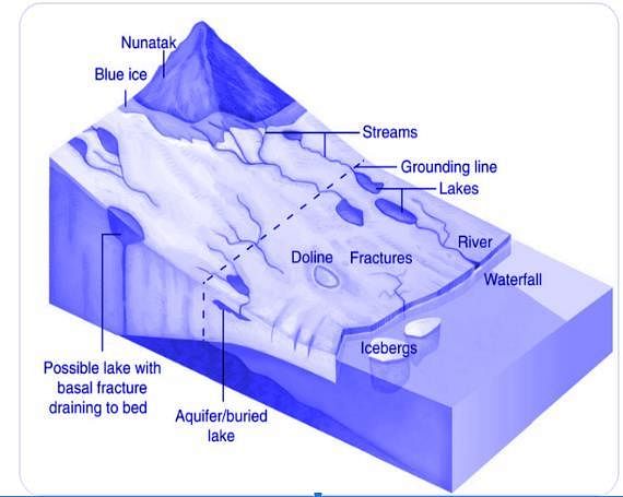
Which of the following statements best describes the term ‘Nunataks’?
Consider the following pairs:
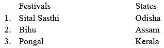
How many of the pairs given above are correct?
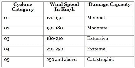
With reference to a Cyclone, consider the following statements:
1. The Indian subcontinent is exposed to nearly 45 percent of the world’s tropical cyclones.
2. The air circulates inward in an anticlockwise direction in the Northern hemisphere and clockwise in the Southern hemisphere in a cyclone.
3. Cyclones are classified on the basis of the wind speed and their capacity to cause damage.
Which of the statements given above are correct?
‘It drains the largest number of glaciers and mountain slopes of the Karakorum, Ladakh, Zaskar and Himalayan Ranges. Originating from the Kailash Mountain, it flows in a constricted valley north-westward through Tibet, where it is called Singi Khamban or Lion’s mouth.’
Which of the following rivers is best described in the passage given above?
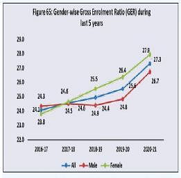
Consider the following statements:
1. The Gross Enrolment Ratio for females in higher education has been consistently greater than that of males in the last 5 years.
2. The male-female gap in literacy rate in India has consistently reduced since Independence.
Which of the statements given above are correct?
Consider the following statements in the context of Central Highlands:
1. The general slope of the highlands is towards the south and south-east.
2. Musi river basin forms the majority part of the region.
Which of the statements given above are correct?
Which of the following are the major features of the Shola forests of Southern India?
1. Stunted trees
2. Large leaves
3. Round and dense canopies
4. Changing colours of leaves
Select the correct answer using the code given below:
Consider the following statements:
1. During equinoxes, all parts of the worldhave equal days and nights.
2. Equinoxes occur during the months ofJune and December every year.
Which of the statements given above is/arecorrect?
Consider the following statements:
1. The Chenab flows through the Wular Lake before entering Pakistan through a deep narrow gorge.
2. The Indus rises west of the Rohtang Pass and flows through the Chamba valley.
3. The Satluj originates in Tibet, passes through the Shipki La and enters the Punjab plains.
Which of the statements given above are incorrect?
Recently, the Ministry of Culture announceda year-long commemoration of the birthanniversary of Santh Sevalal Maharaj. He isa spiritual teacher/guru of which of thefollowing communities?
Consider the following statements:
1. Aesthetic forestry refers to the growth of forests without human intervention.
2. Unlike farm forestry, community forestry takes place on public land.
Which of the statements given above are correct?
With reference to the distribution ofvolcanoes in the world, consider thefollowing statements:
1. Mt. Cameroon is an active volcano inEast African Rift Valley.
2. Mt. Kilimanjaro is an extinct volcano inWest Asia.
3. Most of the volcanic activities take placebelow the sea.
Which of the statements given above are notcorrect?
Consider the following pairs:

How many of the above pairs are correctly matched?
In the context of the Indian Monsoon, whichof the following best describes the reason forthe break in monsoon over northern India?
With reference to the measurement ofearthquakes, consider the following statements:
1. The Richter scale is a magnitude scalecalculated by the logarithm of theamplitude of waves.
2. The Mercalli scale is an intensity scaleused to quantify the effect of anearthquake on human life.
Which of the statements given above is/arecorrect?
Consider the following statements with reference to the British type of climate:
1. The natural vegetation of the British type of climate is temperate evergreen forest.
2. The natural vegetation of the British-type of climate is not suitable for the lumbering industry.
Which of the statements given above are correct?
Consider the following statements regarding the distribution and direction of monsoon rainfall across India:
1. Rainfall in the western Himalayas is often caused by the joining of the Arabin Sea branch and the Bay of Bengal Branch.
2. Arakan valley has a significant role indirecting the Bay of Bengal branch towards the Indian sub-continent.
Which of the statements given above is/are correct?
Which of the following aquifer systems covers the maximum area of India?
Which of the following commonly found plants in India have medicinal properties?
1. Sarpagandha
2. Babool
3. Arjun
4. Kachnar
Select the correct answer using the code given below.
Which of the following traditional water harvesting methods uses ‘kuis’ or ‘beris’ to access percolated rainwater in sandy soil?
Consider the following mountain ranges in India:
1. Satpura Range
2. Shiwalik Range
3. Vindhya Range
What is the order of the above ranges from North to South direction?

Consider the following pairs:

How many of the above pairs are correctly matched?


Important Questions for Practice Test: Geography- 1
Practice Test: Geography- 1 MCQs with Answers
Online Tests for Practice Test: Geography- 1
|
© EduRev
|
Education Revolution
|


|


