UPSC Exam  >  UPSC Tests  >  Test: Geography - 1 - UPSC MCQ

Test: Geography - 1 - UPSC MCQ


Test Description

30 Questions MCQ Test - Test: Geography - 1

Test: Geography - 1 for UPSC 2024 is part of UPSC preparation. The Test: Geography - 1 questions and answers have been prepared according to the UPSC exam syllabus.The Test: Geography - 1 MCQs are made for UPSC 2024 Exam. Find important definitions, questions, notes, meanings, examples, exercises, MCQs and online tests for Test: Geography - 1 below.
Solutions of Test: Geography - 1 questions in English are available as part of our course for UPSC & Test: Geography - 1 solutions in Hindi for UPSC course. Download more important topics, notes, lectures and mock test series for UPSC Exam by signing up for free. Attempt Test: Geography - 1 | 50 questions in 60 minutes | Mock test for UPSC preparation | Free important questions MCQ to study for UPSC Exam | Download free PDF with solutions
Test: Geography - 1 - Question 1

Which of the following statements best describe “Virgin Vegetation”?

Detailed Solution for Test: Geography - 1 - Question 1
  • The type of vegetation which has grown on its own naturally without any aid from human beings or those which have been left untouched or undisturbed by the human beings for a long time are termed as “Virgin vegetation”.

  • The virgin vegetation, which are purely Indian are known as endemic or indigenous species but those which have come from outside India are termed as exotic plants. Thus statement 3 is correct. Example - Unreachable areas of the Amazon rainforest, Trenches in the Ocean etc. Plant community which is endemic to a particular area is known as native species.

  • Plant community formed due to primary succession in an ecosystem are known as Pioneer species. Plant community newly introduced in an ecosystem is known as exotic species.

Test: Geography - 1 - Question 2

With reference to the ‘break in monsoon’, consider the following statements:

1. It happens due to the northward shift of the ITCZ over the foothills of Himalayas.

2. It occurs over the west coast due to wind blowing parallel to the coast.

Which of the statements given above is/are correct?

Detailed Solution for Test: Geography - 1 - Question 2
  • During the south-west monsoon period after having rains for a few days, if rain fails to occur for one or more weeks, it is known as break in the monsoon. These dry spells are quite common during the rainy season. These breaks in the different regions are due to different reasons:

  • Statement 1 is correct (i) In northern India rains are likely to fail if the rain-bearing storms are not very frequent along the monsoon trough or the ITCZ over this region. It also occurs if the ITCZ shifts northward over the foothills of Himalayas and causes heavy rainfall along the foothills of himalayas.

  • This northward shift of the ITCZ creates a high pressure over the plains and thus the South West monsoon winds are not able to flow Statement 2 is correct (ii) Over the west coast the dry spells are associated with days when winds blow parallel to the coast. This fails to produce an orographic effect and thus leads to a break in monsoon. Such breaks are likely to occur in the month of August.

1 Crore+ students have signed up on EduRev. Have you? Download the App
Test: Geography - 1 - Question 3

India is said to experience comparatively milder winters as compared to Central Asia.

Which of the following statements could be the reason(s) for this?

1. The continentality of North India.

2. The Himalayas in the north.

3. A vast coastline.

Which of the statements given above is/are correct?

Detailed Solution for Test: Geography - 1 - Question 3
  • Statement 1 is incorrect. Continentality of any area leads to extreme climatic conditions. Thus, continentality cannot be a reason for winters being mild as they will only aggravate the existing climatic conditions and not balance it.

  • Statement 2 and 3 are correct. India has Himalayas to the north, which have an average height of about 6,000 metres. The Himalayas therefore act as a barrier to cold winds coming from Tibet and other colder regions in Central Asia (Gobi Desert etc). It is because of these mountains that the subcontinent experiences comparatively milder winters as compared to central Asia.

  • India’s vast coastline leads to a moderating influence on India’s climate and thus results in milder winters as compared to Central Asia. The Tropic of Cancer also passes through the middle of the country from the Rann of Kachchh in the west to Mizoram in the east. Almost half of the country, lying south of the Tropic of Cancer, belongs to the tropical area.

  • All the remaining area, north of the Tropic, lies in the sub-tropics. Therefore, India’s climate has characteristics of tropical as well as subtropical climates. This also leads to milder winters in India.

Test: Geography - 1 - Question 4

Consider the following statements:

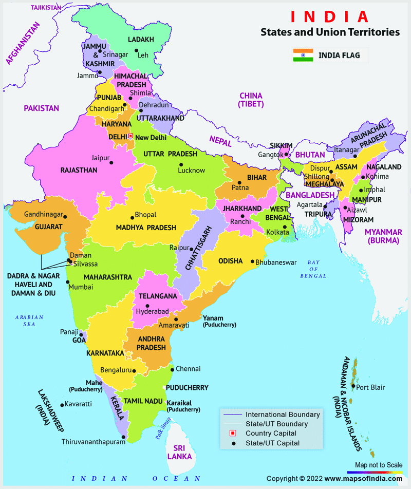
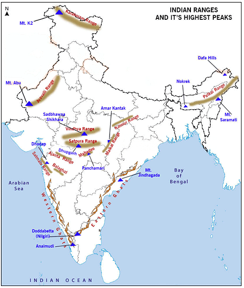
1. Eastern Ghats are broken and uneven whereas Western Ghats form a continuous ridge.

2.The Eastern coastal plains are narrower as compared to the Western coastal plains.

3. Rivers Mahanadi, Godavari, Krishna and Vaigai all drain into the Bay of Bengal.

Which of the statements given above is/are correct?

Detailed Solution for Test: Geography - 1 - Question 4
Option (c) is the correct answer.
  • Statement 1 is correct. Eastern Ghats are a discontinuous range of mountains along India's coast due to the large number of rivers dissecting the eastern ghats as they flow towards the Bay of Bengal. They run from northern Odisha through Andhra Pradesh to Tamil Nadu in the south passing some parts of Karnataka and Wayanad district of Kerala.

  • Statement 2 is not correct. The western coastal plains are narrow strip of coastal plain 50 kilometers in width between the west coast and the western ghats whereas the Eastern coastal plains are much broader stretch of landmass of India, lying between eastern Ghats and the bay of bengal.

  • Statement 3 is correct. A number of east flowing rivers, Mahanadi, Godavari, Krishna, Kaveri, Vaigai drain into the bay of bengal. This happens due to the SoutEast slope of the peninsular plateau.

Test: Geography - 1 - Question 5

This river is mainly known for its badland topography. It originates on the south slope of Vindhyachal range in Madhya Pradesh and is a tributary of river Yamuna. This river is known as?

Detailed Solution for Test: Geography - 1 - Question 5
Option (d) is the correct answer.
  • The running water of Chambal cuts through the clayey soils and makes deep channels as gullies. The land becomes unfit for cultivation and is known as bad land. In the Chambal basin such lands are called ravines.

  • Sometimes water flows as a sheet over large areas down a slope. In such cases the top soil is washed away. Thus such areas of Madhya Pradesh are prone to sheet erosion. The Chambal River is a tributary of the Yamuna River in central India, and thus forms part of the greater Gangetic drainage system.

  • The river flows north-northeast through Madhya Pradesh, running for a time through Rajasthan, then forming the boundary between Rajasthan and Madhya Pradesh before turning southeast to join the Yamuna in Uttar Pradesh state. Tributaries of Chambal are Banas, Mej, Parbati, Kali Sindh, Shipra It is a legendary river and finds mention in ancient scriptures.

  • The perennial Chambal originates at janapav, south of Mhow town, near manpur Indore, on the south slope of the Vindhya Range in Madhya Pradesh. The Chambal River hosts 2 species of crocodiles– the mugger and gharial, freshwater turtles, gangetic river dolphins.

Test: Geography - 1 - Question 6

Consider the following statements with respect to “Inter Tropical Convergence Zone”:

1. It is a broad trough of low pressure in equatorial latitudes.

2. It is in this zone, that the northeast and southeast trade winds converge.

3. It does not extend beyond the tropics.

Which of the statements given above is/are correct?

Detailed Solution for Test: Geography - 1 - Question 6
  • Statement 1 is correct. The Inter Tropical Convergence Zone, or ITCZ, is a belt of low pressure which circles the Earth generally near the equator where the trade winds of the Northern and Southern Hemispheres come together. It is a broad trough of low pressure in equatorial latitudes.

  • Statement 2 is correct. The Intertropical Convergence Zone (ITCZ), known by sailors as the doldrums or the calms because of its monotonous, windless weather, is the area where the northeast and southeast trade winds converge. It encircles Earth near the thermal equator, though its specific position varies seasonally. It shifts as the sun shifts between the Tropic of Cancer and Tropic of Capricorn. When it lies near the geographic Equator, it is called the near- equatorial trough. Where the ITCZ is drawn into and merges with a monsoonal circulation, it is sometimes referred to as a monsoon trough, a usage more common in Australia and parts of Asia including in the subcontinent. Therefore, Northern ITCZ is sometimes referred to as the Monsoonal trough.

  • Statement 3 is correct. The location of the ITCZ gradually varies with seasons, roughly corresponding with the location of the sun (thermal equator). As the heat capacity of the oceans is greater than air over land, migration is more prominent over land. As land tends to heat up more the ITCZ can even shift beyond the Tropics. This can be seen during the heating up of the Tibetan plateau. As the Tibetan plateau heats up it leads to shifting of the Northern ITCZ beyond the Tropic of Cancer over the northern plains.

Test: Geography - 1 - Question 7

Which of the following pairs are correctly matched?

Hot weather phenomena Region

1. Loo West Bengal

2. Kal Baisakhi Odisha

3. Mango showers Karnataka

Select the correct answer using the code given below:

Detailed Solution for Test: Geography - 1 - Question 7

Option (c) is correct.

  • Due to the apparent northward movement of the su n, the global heat belt shifts northward. As such, from March to May, it is hot weather season in India. Due to the hot weather, there is a flow of a strong, gusty, hot and dry wind over the northern plains. This is known as ‘Loo’.

  • Kal Baisakhi, also known as a nor'wester, is a localized thunderstorm and rainfall event that occurs in Odisha and other parts of India and Bangladesh during the summer months of April and May

  • Towards the close of the summer season, pre-monsoon showers are common especially in Kerala and Karnataka. They help in the early ripening of mangoes, and are often referred to as ‘mango showers’.


Test: Geography - 1 - Question 8

Which of the following states in India have made rooftop rainwater harvesting structure compulsory for all the houses across the state?

Detailed Solution for Test: Geography - 1 - Question 8
Option (c) is the correct answer.

Amendments made to Section 215 (a) of the Tamil Nadu District Municipalities Act, 1920 and Building Rules 1973, have made it mandatory to provide rooftop rainwater harvesting structures in all new buildings. Rooftop Rainwater Harvesting is the technique through which rain water is captured from the roof catchments and stored in reservoirs. Harvested rain water can be stored in subsurface groundwater reservoir by adopting artificial recharge techniques to meet the household needs through storage in tanks. The Main Objective of rooftop rainwater harvesting is to make water available for future use. Capturing and storing rainwater for use is particularly important in drylands, hilly, urban and coastal areas.

Test: Geography - 1 - Question 9

In the context of rainfall in India, consider the following statements:

1. There is an increase in rainfall generally from east to west in the Northern Plains.

2. The Coromandel coast receives most of its rain during October and November.

Which of the statements given above is/are incorrect?

Detailed Solution for Test: Geography - 1 - Question 9
  • In India, majority of the rainfall is received during the South West Monsoon (SWM) in the months of June, July, August and September. These SWM winds travel from the Indian Ocean to bring rainfall to the North East and the West coast of India. Statement 1 is incorrect. As we move away from north east towards the northern plains, the intensity of rainfall decreases. The SWM winds after striking the northeast turn towards the northern plains due to the ‘syntaxial bend of Himalayas’. Rainfall thus decreases from east to west in the northern plains because of progressive decrease in the humidity of the winds.

  • As the moisture bearing winds of the Bay of Bengal branch moves further and further inland, they exhaust most of the moisture along the way. The regions of Assam, Meghalaya and Tripura receives higher rainfall as compared to the northern regions of UP, Bihar, Northern Madhya Pradesh etc. Statement no.2 is correct. The Coromandel coast of Andhra Pradesh and Tamil Nadu receives rainfall in the winter season due to northeast trade winds. A part of northeast trade wind blows over Bay of Bengal and gather moisture which causes rainfall in the coromandel coast. The normal annual rainfall of the state is about 945 mm (37.2 in) of which 48% is through the North East monsoon.

  • During October-November, with the apparent movement of the sun towards the south, the monsoon trough or the low-pressure trough over the northern plains becomes weaker. This is gradually replaced by a high-pressure system. The south-west monsoon winds weaken and start withdrawing gradually. By the beginning of October, the monsoon withdraws from the Northern Plains. This leads to the onset of the North East winds from the high-pressure belt (now formed) over the northern plains and results in rainfall on the SouthEast coast of India (Coromandel coast - Andhra Pradesh and Tamil Nadu). In the second half of October, the mercury begins to fall rapidly in northern India. The low- pressure conditions, over northwestern India, get transferred to the Bay of Bengal by early November.

  • This shift is associated with the occurrence of cyclonic depressions, which originate over the Andaman Sea. These cyclones generally cross the eastern coasts of India causing heavy and widespread rain. These tropical cyclones are often very destructive. The thickly populated deltas of the Godavari, the Krishna and the Kaveri are frequently struck by these cyclones, which causes great damage to life and property. The bulk of the rainfall of the Coromandel Coast is derived from depressions and cyclones.

Test: Geography - 1 - Question 10

The character and extent of vegetation of a region is mainly determined by which of the

following factors?

1. Temperature

2. Photoperiod

3. Relief

4. Precipitation

5. Soil

Select the correct answer using the code given below:

Detailed Solution for Test: Geography - 1 - Question 10
  • The character and extent of vegetation are mainly determined by temperature along with humidity in the air, precipitation and soil. Temperature: On the slopes of the Himalayas and the hills of the Peninsula above the height of 915 metres, the fall in the temperature affects the types of vegetation and its growth, and changes it from tropical to subtropical to temperate and alpine vegetation.

Photoperiod:

  • The variation in duration of sunlight at different places is due to differences in latitude, altitude, season and the duration of the day. Due to longer duration of sunlight, trees grow faster in summer.

Precipitation:

  • In India almost, the entire rainfall is brought in by the advancing southwest monsoon (June to September) and retreating northeast monsoons. Areas of heavy rainfall have more dense vegetation as compared to other areas of less rainfall.

Land (Relief):

  • Land affects the natural vegetation directly and indirectly. The nature of land influences the type of vegetation. The fertile level is generally devoted to agriculture. The undulating and rough terrains are areas where grassland and woodlands develop and give shelter to a variety of wildlife. Soil: The soils also vary over space. Different types of soils provide basis for different types of vegetation. The sandy soils of the desert support cactus and thorny bushes while wet, marshy, deltaic soils support mangroves and deltaic vegetation. The hill slopes with some depth of soil have conical trees. Thus all the options are correct and hence answer is option (d).

Test: Geography - 1 - Question 11

With reference to Air Independent Propulsion (AIP) , consider the following statements:

1. It helps to make the diesel generator less dependent on surface air.

2. It offers the possibility of increasing underwater endurance .

3. It has a force multiplier effect on the lethality of a diesel electric submarine .

Which of the statements given above are correct?

Detailed Solution for Test: Geography - 1 - Question 11

Recently ,French company Naval Group announced that it is unable to participate in India's P-75I project due to conditions mentioned in the request for proposal (RFP) related to the Air Independent Propulsion (AIP) system. Statements 1,2 and 3 are correct :

  • AIP is a mechanism that allows the batteries to be charged even while the boat is submerged.

    • However, even with AIP, the submarine needs to surface every three weeks or so.

  • It offers the possibility of increasing underwater endurance by a factor of up to 3 or 4, which reduces the indiscretion ratio significantly”.

  • It has a force multiplier effect on lethality of a diesel electric submarine as it enhances the submerged endurance of the boat several fold.

    • Fuel cell-based AIP has merits in performance compared to other technologies.

  • It helps to make the diesel generator less dependent on surface air.

  • India has been working to develop AIP technology indigenously as well.

    • There are different types of AIP mechanisms available and India is looking for the P-75I project is AIP based on fuel cells.

    • These cells convert chemical energy into electrical energy, recharging the batteries of the submarine.

Test: Geography - 1 - Question 12

If you travel from Jammu and kashmir to Mizoram, what is the minimum number of states within India through which you can travel, excluding the origin and destination?

Detailed Solution for Test: Geography - 1 - Question 12

Option (b) is the correct answer.

Test: Geography - 1 - Question 13

Consider the following statements regarding Intergovernmental Oceanographic Commission (IOC)

1. It has functional autonomy within UNESCO.

2. It organises IOWave18 exercise in the Indian Ocean.

Which of the statements given above is/are correct?

Detailed Solution for Test: Geography - 1 - Question 13
Option (c) is the correct answer.
  • Statement 1 is correct. The Intergovernmental Oceanographic Commission of UNESCO (IOC- UNESCO) was established in 1960. It is a body with functional autonomy within UNESCO. It is the only competent organization for marine science within the UN system.

  • Statement 2 is correct. India, along with 23 other Indian Ocean Nations, participated in a major Indian ocean-wide tsunami mock exercise (drill) on 4th & 5th September, 2018. The Exercise, known as IOWave18, was organized by the Intergovernmental Oceanographic Commission (IOC) of UNESCO. IOC coordinated the setting up of the Indian Ocean Tsunami Warning and Mitigation System (IOTWMS) following the 26th December 2004 tsunami. KB) The purpose of the Commission is to promote international cooperation and to coordinate programmes in research, services and capacity-building, in order to learn more about the nature and resources of the ocean and coastal areas and to apply that knowledge for the improvement of management, sustainable development, the protection of the marine environment, and the decision-making processes of its Member States. In addition, IOC is recognized through the United Nations Convention on the Law of the Sea (UNCLOS) as the competent international organization in the fields of Marine Scientific Research and Transfer of Marine Technology.

Test: Geography - 1 - Question 14

Consider the following statements regarding “Jet Streams”:

1. Jet Streams are a narrow belt of high altitude (above 12,000 m) winds in the troposphere.

2. The western cyclonic disturbances experienced in the north and north-western parts of India are brought in by westerly flow of Jet Streams.

3. An easterly jet stream blows over peninsular India during the winter months.

Which of the statements given above is/are correct?

Detailed Solution for Test: Geography - 1 - Question 14
  • Statement 1 is correct. Jet streams are a narrow belt of high altitude (above 12,000 m) winds in the troposphere. Their path has a meandering shape. The strongest jet streams are the polar jet streams. The Jet streams are a product of two factors : Solar insolation that forms atmospheric circulation of winds (Hadley cell etc) and the Coriolis force. Their speed varies from about 110 km/h in summer to about 184 km/h in winter. A number of separate jet streams have been identified. The most constant are the mid-latitude and subtropical jet stream.

  • Statement is 2 correct. The western cyclonic disturbances are weather phenomena of the winter months brought in by the westerly flow (jet streams) from the Mediterranean region. They usually influence the weather of the north and north-western regions of India and bring about winter rainfall in these regions. They are large cyclonic systems that are very important with respect to harvesting of the rabi crops in the regions of Uttarakhand, Punjab, Haryana, northern Rajasthan and northwestern Uttar Pradesh.

  • Statement 3 is incorrect. The ‘subtropical westerly jet stream’ is found over 27 - 30 north latitude. These jet streams blow south of Himalayas all throughout the year except in summer. In summer the subtropical westerly jet stream shifts north of Himalayas with the apparent movement of the sun towards the north of India. After the shift of the subtropical westerly jet stream northward, there is a sudden “burst” of monsoon in India. This leads to the formation of an easterly jet stream, called the ‘tropical easterly jet stream’ which blows over peninsular India, approximately over 14°N during the summer months.

Test: Geography - 1 - Question 15

With reference to International Commission on Irrigation and Drainage (ICID), consider the following statements:

1. It is a non-governmental organization.

2. It maintains a register of Heritage Irrigation Structures

3. Punjab in the first state having a Heritage Irrigation Structure in the ICID register.

Which of the statements given above is/are correct?

Detailed Solution for Test: Geography - 1 - Question 15
Option (a) is the correct answer.
  • Statement 1 is correct. The International Commission on Irrigation and Drainage (ICID) was established in 1950. It is a leading scientific, technical, an international not-for-profit, non- governmental organization. ICID is a professional network of experts from across the world in the field of irrigation, drainage, and flood management.

  • Statement 3 is incorrect. A meeting of the International Executive Council, the highest decision-making body of International Commission on Irrigation and Drainage (ICID), has accepted Telangana government’s nomination of Sadarmat anicut across river Godavari in Nirmal district and Pedda Cheruvu in Kamareddy district in the ICID Register of Heritage Irrigation Structures at Saskatoon in Canada. Thus statement 2 is correct. Its main mission is to promote ‘Sustainable agriculture water management’ to achieve ‘Water secure world free of poverty and hunger through sustainable rural development’. ICID initially had 11 countries as Founder Members (Brazil, Egypt, India, Indonesia, Italy, Netherlands, Serbia (former Yugoslavia), Sri Lanka, Switzerland, Thailand and Turkey). Its Secretariat (Central Office) is located in New Delhi.

Test: Geography - 1 - Question 16

Arrange the following mountain ranges from North to south:

1. Satpura

2. Himalayan

3. Aravali

4. Vindhya

Select the correct answer using the code given below:

Detailed Solution for Test: Geography - 1 - Question 16
Option (a) is the correct answer.

Test: Geography - 1 - Question 17

Consider the following statements:

1. The Tea plant grows well in the subtropical and temperate climates.

2. The Tea plant requires heavy seasonal rainfall for its optimum growth.

3. India is the largest producer of Tea in the world.

Which of the statements given above is/are not correct?

Detailed Solution for Test: Geography - 1 - Question 17
  • Tea cultivation is an example of plantation agriculture. It is also an important beverage crop introduced in India initially by the British. Today, most of the tea plantations are owned by Indians.

  • Statement 1 is incorrect. The tea plant grows well in tropical and sub-tropical climates endowed with deep and fertile well-drained soil, rich in humus and organic matter. Tea bushes require warm and moist frost-free climate all through the year.

  • Statement 2 is incorrect. Frequent showers evenly distributed over the year ensure continuous growth of tender leaves. Tea is a labor-intensive industry. It requires abundant, cheap and skilled labour. Tea is processed within the tea garden to restore its freshness. Major tea producing states are Assam, hills of Darjeeling and Jalpaiguri districts, West Bengal, Tamil Nadu and Kerala. Apart from these, Himachal Pradesh, Uttarakhand, Meghalaya, Andhra Pradesh and Tripura are also tea- producing states in the country. Statement 3 is incorrect. India is the second largest producer of tea after China

Test: Geography - 1 - Question 18

Consider the following statements regarding the Geographical Indication (GI) Tag:

1. It is established under the Patents Act, 1970.

2. They are covered under the WTO Agreement of TRIPS (Trade Related aspects of Intellectual Property Rights)

Which of the statements given above is/are correct?

Detailed Solution for Test: Geography - 1 - Question 18
  • Statement 1 is incorrect: In December 1999, the Parliament had passed the Geographical Indications of Goods (Registration and Protection) Act,1999. This Act seeks to provide for the registration and better protection of geographical indications relating to goods in India. It confers legal protection to Geographical Indications in India and prevents unauthorised use of a Registered Geographical Indication by others.The Act would be administered by the ‘Controller General of Patents, Designs and TradeMarks’ - who is the Registrar of Geographical Indications.

  • Statement 2 is correct: GIs have been defined under Article 22(1) of the WTO Agreement of TRIPS (Trade Related aspects of Intellectual Property Rights) Agreement as: "Indications which identify a good as originating in the territory of a member, or a region or a locality in that territory, where a given quality, reputation or characteristic of the good is essentially attributable to its geographic origin." Thus, GI tag is internationally recognised. Some recent GI tags are - Kandhamal Haldi (Odisha), Rasagola (Odisha), Sirsi Supari (Karnataka), Erode Turmeric (Tamil Nadu), Marayoor Jaggery (Tamil Nadu), Shahi Litchi (Bihar) etc.

Test: Geography - 1 - Question 19

Consider the following statement regarding ‘Weather’ and ‘climate’.

1. Climate refers to the sum total of weather conditions and variations over a large area for a

long period of time, while Weather refers to the state of the atmosphere over an area at any point of time.

2. The elements of weather and climate differs according to latitudinal shift.

Which of the statements given above is/are correct?

Detailed Solution for Test: Geography - 1 - Question 19
  • Statement 1 is correct. Climate describes what the weather is like over a long period of time in a specific area. Different regions can have different climates. To describe the climate of a place, we might say what the temperatures are like during different seasons, how windy it usually is, or how much rain or snow typically falls. Weather refers to short-term changes in the atmosphere. Even though there’s only one atmosphere on Earth, the weather isn’t the same all around the world. Weather is different in different parts of the world and changes over minutes, hours, days, and weeks.

  • Statement 2 is incorrect. The elements of weather and climate are the same, i.e. temperature, atmospheric pressure, wind, humidity and precipitation. At any point of time, the elements to decide the weather and climate of the region does not change, but remains constant.

Test: Geography - 1 - Question 20

With reference to Jog Falls , consider the following statements:

1. It is created by the Sharavathi River.

2. It is the second-highest plunge waterfall in India.

3. It is situated in Kerala.

Which of the statements given above are correct?

Detailed Solution for Test: Geography - 1 - Question 20

Jog Falls project suffers setback as Centre asks Karnataka about impact assessment.

  • Statements 1 and 2 are correct : Jog Falls is created by the Sharavathi River falling from a height of 253 m (830 ft), making it the second-highest plunge waterfall in India.

    It is also called by alternative names of Gerusoppa falls, Gersoppa Falls and Jogada Gundi.

  • Statement 3 is not correct : Located near Sagara, Shimoga District of Karnataka state.

Test: Geography - 1 - Question 21

Consider the following statements regarding United Nations Sustainable Development Framework (UNSDF)

1. It supports India in achieving its key national development priorities.

2. It puts a special focus on the North-East and the aspirational districts.

Which of the statements given above is/are correct?

Detailed Solution for Test: Geography - 1 - Question 21
Option (c) is the correct answer.
  • Statement 1 is correct. UNSDF 2018-2022 outlines development cooperation strategy between Union Government and United Nations Country Team in India in support of achievement of India’s key national development priorities and Sustainable Development Goals (SDGs).

  • Statement 2 is correct. The programmatic work outlined in the UNSDF targets the seven low- income states (Bihar, Chhattisgarh, Jharkhand, MP, Odisha, Rajasthan, UP), the North-East region, and the aspirational districts identified earlier this year by the NITI Aayog. NITI Aayog and United Nations in India signed the Sustainable Development Framework for 2018-2022 at a function in New Delhi. It was framed following highly participative process, in consultation with government entities, civil society representatives, academia, and the private sector. Focus areas include poverty and urbanization, health, water, and sanitation, education, climate change, nutrition and food security, clean energy, and disaster resilience; skilling, entrepreneurship, job creation, gender equality and youth development. UNSDF also includes set of UN flagship programs that are aligned with major government schemes. These flagship programs will be scalable innovative, multi-sectoral solutions to some of the most pressing development challenges that India faces and also serve as catalysts for increased investment of development finance. UNSDF programmes range from affordable housing for poor to increasing access to clean energy in rural off-grid areas, protecting all children from vaccine-preventable diseases, providing quality education for all children and skilling for young people, especially young girls and ending stunting to improving child sex ratio.

Test: Geography - 1 - Question 22

Consider the following statements:

1. Cultivation of wheat requires high humidity with annual rainfall above 100cm.

2. Cultivation of rice requires annual rainfall of 50cm to 75cm.

Which of the statements given above is/are correct?

Detailed Solution for Test: Geography - 1 - Question 22
  • Statement 1 is incorrect. Rice: It is the staple food crop of a majority of the people in India. Our country is the second largest producer of rice in the world after China. It is a kharif crop which requires high temperature (above 25°C) and high humidity with annual rainfall above 100 cm. In the areas of less rainfall, it grows with the help of irrigation. Rice is grown in the plains of north and north-eastern India, coastal areas and the deltaic regions. Development of dense network of canal irrigation and tubewells have made it possible to grow rice in areas of less rainfall such as Punjab, Haryana and western Uttar Pradesh and parts of Rajasthan.

  • Statement 2 is incorrect. Wheat: This is the second most important cereal crop. It is the main food crop, in north and north-western part of the country. This rabi crop requires a cool growing season and bright sunshine at the time of ripening. It requires 50 to 75 cm of annual rainfall evenly distributed over the growing season. There are two important wheat-growing zones in the country – the Ganga-Satluj plains in the north-west and black soil region of the Deccan. The major wheat-producing states are Punjab, Haryana, Uttar Pradesh, Madhya Pradesh, Bihar and Rajasthan.

Test: Geography - 1 - Question 23

Consider the following statements:

1. Seifs are crescent shaped sand dunes.

2. Barchans are longitudinal sand ridges.

Which of the statements given above is/are correct?

Detailed Solution for Test: Geography - 1 - Question 23
Option (d) is the correct option.

Both the statements are incorrect. Seif is a long, narrow sand dune or chain of dunes, generally oriented in a direction parallel to the prevailing wind or in a direction resulting from two or more winds blowing at acute angles to each other. The dune crest consists of a series of peaks and gaps, and the steep, or slip, face may change sides of the dune according to changes in wind direction. Most Seif dunes occur in the open desert. Barchan, also spelled Barkhan, crescent-shaped sand dune produced by the action of wind predominately from one direction. One of the commonest types of dunes, it occurs in sandy deserts all over the world. Barchans are convex facing the wind, with the horns of the crescent pointing downwind and marking the lateral advancement of the sand.

Test: Geography - 1 - Question 24

With reference to Ayushman Bharat- Pradhan Mantri Jan Arogya Yojana, consider the following statements:

1. The on-going centrally sponsored schemes Rashtriya Swasthya Bima Yojana and the Senior Citizen Health Insurance Scheme are subsumed in Ayushman Bharat Mission.

2. It has a defined benefit cover of Rs. 5 lakh per family per year.

3. Beneficiaries covered under the scheme are allowed to take cashless benefits from any of

the public/private empanelled hospitals across the country.

Which of the statements given above is/are correct?

Detailed Solution for Test: Geography - 1 - Question 24
Option (d) is the correct answer.
  • Statement 1 is correct. Ayushman Bharat - National Health Protection Mission has included the on-going centrally sponsored schemes - Rashtriya Swasthya Bima Yojana and the Senior Citizen Health Insurance Scheme under its ambit.

  • Statement 2 is correct. Ayushman Bharat is a National Health Protection Scheme which covers over 10 crore poor and vulnerable families (approximately 50 crore beneficiaries) providing coverage upto 5 lakh rupees per family per year for secondary and tertiary care hospitalization. Statement 3 is correct. Benefits of the scheme are portable across the country and a beneficiary covered under the scheme is allowed to take cashless benefits from any public/private enlisted hospitals across the country.

  • Salient features of Ayushman Bharat include: Ayushman Bharat - National Health Protection Mission will be an entitlement-based scheme with entitlement decided on the basis of deprivation criteria in the SECC database.

  • The beneficiaries can avail benefits in both public and empanelled private facilities.

  • To control costs, the payments for treatment will be done on package rate (to be defined by the Government in advance) basis. One of the core principles of Ayushman Bharat - National Health Protection Mission is to cooperative federalism and flexibility to states.

  • For giving policy directions and fostering coordination between the Centre and States, it is proposed to set up Ayushman Bharat National Health Protection Mission Council (AB- NHPMC) at apex level Chaired by Union Health and Family Welfare Minister. States would need to have State Health Agency (SHA) to implement the scheme.

  • To ensure that the funds reach SHA on time, the transfer of funds from Central Government through Ayushman Bharat - National Health Protection Mission to State Health Agencies may be done through an escrow account directly. In partnership with NITI Ayog, a robust, modular, scalable and interoperable IT platform will be made operational which will entail a paperless, cashless transaction.

Test: Geography - 1 - Question 25

Consider the following statement regarding National Mission on Government eMarketplace (GeM):

1. It aims to enhance transparency, efficiency and speed in public procurement of agricultural produce only.

2. It also offers offline, end-to-end solution for procurement of commonly used goods and services.

3. It can be used only by Central Public Sector Undertakings (CPSU).

Which of the statements given above is/are incorrect?

Detailed Solution for Test: Geography - 1 - Question 25
Option (a) is the correct answer.
  • Statement 1 and 2 are incorrect. Government e Marketplace is the National Public Procurement Portal offering an online, end-to-end solution for procurement of common use goods and services by government departments. GeM provides an open, inclusive, transparent and efficient online marketplace.

  • Statement 3 is incorrect. It is used by Central and State Government Ministries and Departments, Central and State Public Sector Undertakings (CPSUs & SPSUs), autonomous institutions and local bodies. The National Mission on GeM (NMG) was launched on 5th September 2018 till 17th October 2018. The objective of the Mission was to accelerate the adoption and use of Procurement by Major Central Ministries, States and UTs and their agencies (including CPSUs/PSUs, Local Bodies) on the GeM platform. The objectives GeM are: Promote inclusiveness by catapulting various categories of sellers and service providers Highlight and communicate the ‘value addition’ by way of transparency and efficiency in public procurement, including corruption free governance. Achieve cashless, contactless and paperless transaction in line with Digital India objectives. Increase overall efficiency leading to significant cost savings on government expenditure in Procurement. Maximizing ease in availability of all types of products and services bought by the Government.

Test: Geography - 1 - Question 26

Which of the following statements is not correct regarding Planet Venus?

Detailed Solution for Test: Geography - 1 - Question 26
Indian Space Research Organisation (ISRO) is working on an orbiter mission to Planet Venus. Option c is correct: Venus is Earth’s closest planetary neighbour which is similar in structure but slightly smaller than Earth, it is the second planet from the sun. Thus, Venus has been called Earth’s twin.
  • Venus is wrapped in a thick, toxic atmosphere filled with carbon dioxide that traps in heat.

  • The temperature of Venus is too high, and its atmosphere is highly acidic, just two of the things that would make life impossible.

  • Surface temperatures reach a scorching 880 degrees Fahrenheit (471 degrees Celsius), hot enough to melt lead.

  • It has no moons and no rings.

  • It spins from east to west, the opposite direction from all other planets in our solar system but the same as Uranus.

  • Venus’ solid surface is a volcanic landscape covered with extensive plains featuring high volcanic mountains and vast ridges.

Test: Geography - 1 - Question 27

Consider the following statements about retreating monsoon:

1. It begins when the low-pressure trough over the northern plains starts moving southwards.

2. It is associated with wet weather in North India and rains in eastern part of Peninsula.

3. It is characterized by wind blowing from Northeast to Southwest.

Which of the statements given above is/are not correct?

Detailed Solution for Test: Geography - 1 - Question 27
  • Statement 1 is correct. The months of October and November are known for retreating monsoons. By the end of September, the southwest monsoon becomes weak as the low-pressure trough of the Ganga plain starts moving southward in response to the southward movement of the sun. By the beginning of October, the low pressure covers northern parts of the Bay of Bengal and by early November, it moves over Karnataka and Tamil Nadu. By the middle of December, the centre of low pressure is completely removed from the Peninsula. The retreating Southwest monsoon season is marked by clear skies and rise in temperature. The land is still moist. Owing to the conditions of high temperature and humidity, the weather becomes rather oppressive. This is commonly known as the ‘October heat’. In the second half of October, the mercury begins to fall rapidly, particularly in northern India. The weather in the retreating monsoon is dry in north India but it is associated with rain in the eastern part of the Peninsula. Here, October and November are the rainiest months of the year. Hence statement 2 is incorrect.

  • Statement 3 is correct because during the winter monsoon or retreating monsoon, the ITCZ moves southward, and so the reversal of winds from Northeast to South and southwest, takes place.

    So, option B is correct.

Test: Geography - 1 - Question 28

Consider the following statements:

1. Forest area is the area notified and recorded as the forest land irrespective of the existence of trees.

2. Forest cover is the area occupied by forests with canopy.

3. Both the forest area and forest cover are based on the records of State Revenue Department.

Which of the statements given above is/are correct?

Detailed Solution for Test: Geography - 1 - Question 28
According to state records, the forest area covers 23.28 per cent of the total land area of the country. It is important to note that the forest area and the actual forest cover are not the same.
  • According to India’s State of Forest Report 2011, the actual forest cover in India is only 21.05 per cent. Of the forest cover, the share of dense and open forests is 12.29 and 8.75 per cent respectively. Both forest area and forest cover varies from state to state. Lakshadweep has zero percent forest area; Andaman and Nicobar Islands have 86.93 per cent. Most of the states with less than 10 percent of the forest area lie in the north and northwestern part of the country.

  • These are Rajasthan, Gujarat, Punjab, Haryana and Delhi. Most of the forests in Punjab and Haryana have been cleared for cultivation. States with 10-20 per cent forest area are Tamil Nadu and West Bengal.

  • In Peninsular India, excluding Tamil Nadu, Dadra and Nagar Haveli and Goa, the area under forest cover is 20-30 per cent. The northeastern states have more than 30 percent of the land under forest. Hilly topography and heavy rainfall are good for forest growth.

Test: Geography - 1 - Question 29

With reference to National Digital Communications Policy, 2018, consider the following statements:

1. It aims to provide universal broadband connectivity to every citizen.

2. It aims to establish Common Service Ducts and utility corridors in all new city and highway road projects.

Which of the statements given above is/are correct?

Detailed Solution for Test: Geography - 1 - Question 29
Option (c) is the correct answer.

Statement 1 is correct. The key objectives of the policy are:

  • Broadband for all;

  • Creating four million additional jobs in the Digital Communications sector;

  • Enhancing the contribution of the Digital Communications sector to 8% of India's GDP from ~ 6% in 2017;

  • Propelling India to the Top 50 Nations in the ICT Development Index of ITU from 134 in 2017;

  • Enhancing India's contribution to Global Value Chains; and

  • Ensuring Digital Sovereignty.

Statement 2 is correct. The policy advocates:

  • Establishment of a National Digital Grid by creating a National Fibre Authority;

  • Establishing Common Service Ducts and utility corridors in all new city and highway road projects;

  • Creating a collaborative institutional mechanism between Centre, States and Local Bodies for Common Rights of Way, standardization of costs and timelines;

  • Removal of barriers to approvals; and

  • Facilitating development of Open Access Next Generation Networks. Features: The policy aims to Provide universal broadband connectivity at 50 Mbps to every citizen;

  • Provide 1 Gbps connectivity to all Gram Panchayats by 2020 and 10 Gbps by 2022;

  • Ensure connectivity to all uncovered areas;

  • Attract investments of USD 100 billion in the Digital Communications Sector;

  • Train one million manpower for building New Age Skills;

  • Expand IoT ecosystem to 5 billion connected devices;

  • Establish a comprehensive data protection regime for digital communications that safeguards the privacy, autonomy and choice of individuals

  • Facilitate India's effective participation in the global digital economy;

  • Enforce accountability through appropriate institutional mechanisms to assure citizens of safe and

  • Secure digital communications infrastructure and services.

Test: Geography - 1 - Question 30

Consider the following statements:

1. In most of the tribal areas of the north-east India, minerals are owned by individuals or communities

2. Mining of coal in Meghalaya is done by digging long narrow tunnels.

Which of the statements given above is/are correct?

Detailed Solution for Test: Geography - 1 - Question 30
Recently workers were trapped in a Rat hole mine in Meghalaya for 18 days.
  • Statement 1 is correct. Most of the minerals in India are nationalised and their extraction is possible only after obtaining due permission from the government. But in most of the tribal areas of the north-east India, minerals are owned by individuals or communities.

  • Statement 2 is correct. In Meghalaya, there are large deposits of coal, iron ore, limestone and dolomite etc. Coal mining in Jowai and Cherapunjee is done by family members in the form of a long narrow tunnel, known as ‘Rat hole’ mining. It is a primitive and hazardous method of mining for coal, with tunnels that are only 3-4 feet in diameter (hence, rat-hole), leading to pits ranging from 5-100 sq. mt deep. There are two types of rat-holes: when dug into the ground these are vertical shafts leading to the mines where horizontal tunnels are dug; the second type is where horizontal holes are dug directly in the hillsides to reach coal seams (bed of coal). The coal is taken out manually, loaded into a bucket or a wheelbarrow and dumped on a nearby un-mined area. From here, it is carried to larger coal dumps near highways for trade and transportation The National Green Tribunal has declared such activities illegal and recommended that these should be stopped forthwith. The National Green Tribunal banned rat-hole mining in Meghalaya in 2014 on a petition that said acidic discharge from the mines was polluting the Kopili river. But the practice continues unabated.

View more questions
Information about Test: Geography - 1 Page
In this test you can find the Exam questions for Test: Geography - 1 solved & explained in the simplest way possible. Besides giving Questions and answers for Test: Geography - 1, EduRev gives you an ample number of Online tests for practice

Top Courses for UPSC

Download as PDF

Top Courses for UPSC