Test: Geography - 2 - UPSC MCQ
30 Questions MCQ Test - Test: Geography - 2

Consider the following statements:
The highest peak of peninsular India Anamudi, lies on the border of Kerala and Tamil Nadu.
Meghalaya- Mikir uplands forms a part of Peninsular India.
Which of the statements given above is/are correct?
The highest peak of peninsular India Anamudi, lies on the border of Kerala and Tamil Nadu.
Meghalaya- Mikir uplands forms a part of Peninsular India.
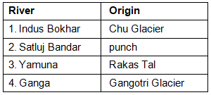
Which of the following sets of pair(s) is/are correctly matched?
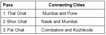
Select the correct answer using the code given below:

Consider the following statements with reference to Western Ghats:
They were formed due to down warping of a part of land into the Arabian Sea.
They are are an example of Block Mountains.
They run across 5 states in India.
Which of the statements given above is/are correct?
They were formed due to down warping of a part of land into the Arabian Sea.
They are are an example of Block Mountains.
They run across 5 states in India.
With reference to the Aravalli Range, consider the following statements:
It is one of the oldest fold mountain ranges of the world.
Its height increases from north to south.
It runs across Haryana, Rajasthan and Delhi.
Which of the statements given above is/are correct?
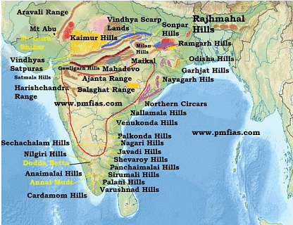
Arrange the following hills from North to South:
Javadi Hills
Shevaroy Hills
Anaimalai
Nilgiri Hills
Cardamom Hills
Select the correct answer using the code below:
Consider the following statements regarding “Monsoon Trough”:
It is a low-pressure area that extends from heat low over Pakistan to the Head Bay of Bengal.
When it is located to the south of its normal position, there is active rainfall over peninsular Indian regions.
Which of the statements given above is/are correct?
Consider the following statements:
- The main central thrust separates the Greater Himalayas from the Trans - Himalayas.
- The main boundary fault separates the Greater Himalayas from the Lesser Himalayas.
- The Himalayan front fault separates Shiwalik from Northern plains of India.
Which of the statements given above is/are not correct?
It is a pass located on the Indo-China Border and is strategically very important. It also forms part of the ancient silk route. It connects the Indian state of Sikkim with China’s Tibet
Autonomous Region. It was reopened in 2006 after 1962 Indo – China war. It is located on the way to Kailash Mansarovar. The above- mentioned pass is?
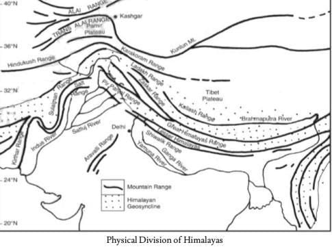
Consider the following statements with reference to Himalayas:
Greater Himalayas receives less rainfall than lesser Himalayas.
Longitudinal Valleys between Shiwalik and lesser Himalayas are known as Dun or Doon.
Himalayas is broader in west but narrows towards the east.
Which of the statements given above is/are correct?
Consider the following statements:
Peninsular India was part of Gondwanaland.
All the rocks in Peninsular India are from the Precambrian period.
Which of the statements given above is/are not correct?
Consider the following statements regarding fast track courts:
Fast track courts are set up by the Central government in consultation with the Supreme Court of India.
Judges are appointed on an ad hoc basis by the Concerned High Courts.
The Central government provides funds for these courts.
Which of the statements given above is/are correct?
Consider the following statement regarding Gross enrolment ratio (GER):
It is the number of students enrolled in a given level of education as a percentage of the total population of that age.
It is always equal to or less than 100 percent.
Which of the statements given above is/are correct?
Consider the following statements:
The Vindhyas range extends from Gujarat to Bihar.
Satpura range was formed due to tectonic activities and are known as Horst landforms.
The Vindhyas form the southern edge of the Malwa Plateau.
Which of the statements given above is/are correct?
Chotanagpur plateau does not extend to which of the following states?
Chattisgarh
Jharkhand
Madhya Pradesh
Maharashtra
Select the correct answer using the code given below:
Consider the following statements regarding New Space India Limited (NSIL):
It is a wholly owned Government of India undertaking under the administrative control of Indian space research organization (ISRO).
It will manufacture Small Satellite Launch Vehicle (SSLV) in collaboration with the
Private Sector.
It will not work on any functions assigned to Antrix corporation.
Which of the statements given above is/are correct?
With reference to Union Territory of Puducherry, consider the following statements:
It comprises 3 districts only viz. Karaikal, Yanam Mahe.
Karaikal is on the western coast of India.
Which of the statements given above is/are correct?
Which of the following correctly describes a distinctly peculiar landform known as
‘Karewas’?
Consider the following statements:
Khadar is a narrow, porous, northernmost stretch of Indo-Gangetic plain
Bangar is the older alluvium along the river beds forming terraces higher than the
floodplain.
Bhabhar is an ill-drained, damp (marshy) and thickly forested narrow tract to the south of Bhabar
Terai is composed of newer alluvium and forms the flood plains along the river banks.
Which of the statements given above is/are not correct?
Which of the following rivers is/are tributarie(s) of the Godavari?
Indravati
Bhima
Sabari
Hemavati
Select the correct answer using the code given below:
Which of the following appropriately defines Reh, Kallar or Thur?
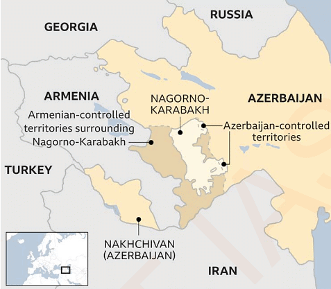
Consider the following statements:
Nagorno Karabakh region is surrounded by Armenia, Azerbaijan and Iran.
Armenia shares a border with the Caspian Sea.
Which of the statements given above is/are correct?
Which of the following rivers have their origin in Western Ghats?
Tamraparni
Mahanadi
Tapi
Kaveri
Select the correct answer from the code given below:
With reference to the Indo-Gangetic- Brahmaputra plains, consider the following statements:
1. It is also known as the Granary of India.
Majority of the rivers traversing these plains are perennial in nature.
It is rich in metallic and natural gas deposits.
Which of the statements given above is/are not correct?
Which of the following rivers is/are the example of Antecedent Rivers?
Indus
Yamuna
Satluj
Tista
Select the correct answer from the code given below:
Which of the following sets of pair(s) is/are correctly matched?
Select the correct answer using the code given below:
Which of the following is/are the right-hand tributaries of Indus river?
Jhelum
Shyok
Swat
Gilgit
Select the correct answer from the code given below:
Which of the following is/are the main objective of the ‘National Water Grid Project’?
Linking of major rivers of India.
Hydropower generation.
To accelerate groundwater recharge.
Which of the statements given above is/are correct?
With reference to the process of Denudation, consider the following statements:
Frost is an agent of Erosion.
Wind is an agent of both weathering and erosion.
Which of the statements given above is/are correct?
With reference to River Rejuvenation, consider the following statements:
It takes place because of the upliftment or depression of the land or rise and fall in sea level.
A positive movement occurs when there is an uplift of land or a fall in sea level.
A negative movement occurs when there is depression of land or a rise in sea level.
Which of the statements given above is/are correct?
Consider the following statements:
The Himalayan province is generally deficient in underground water resource.
The sedimentary province of Kerala, Gujarat and Tamil Nadu are rich in underground water resource.
Which of the statements given above is/are correct?
Important Questions for Geography - 2
Geography - 2 MCQs with Answers
Online Tests for Geography - 2
|
© EduRev
|
Education Revolution
|


|


