Class 9 Exam  >  Class 9 Tests  >  Social Studies (SST) Class 9  >  Test: India- Size And Location- 1 - Class 9 MCQ

Test: India- Size And Location- 1 - Class 9 MCQ


Test Description

10 Questions MCQ Test Social Studies (SST) Class 9 - Test: India- Size And Location- 1

Test: India- Size And Location- 1 for Class 9 2025 is part of Social Studies (SST) Class 9 preparation. The Test: India- Size And Location- 1 questions and answers have been prepared according to the Class 9 exam syllabus.The Test: India- Size And Location- 1 MCQs are made for Class 9 2025 Exam. Find important definitions, questions, notes, meanings, examples, exercises, MCQs and online tests for Test: India- Size And Location- 1 below.
Solutions of Test: India- Size And Location- 1 questions in English are available as part of our Social Studies (SST) Class 9 for Class 9 & Test: India- Size And Location- 1 solutions in Hindi for Social Studies (SST) Class 9 course. Download more important topics, notes, lectures and mock test series for Class 9 Exam by signing up for free. Attempt Test: India- Size And Location- 1 | 10 questions in 10 minutes | Mock test for Class 9 preparation | Free important questions MCQ to study Social Studies (SST) Class 9 for Class 9 Exam | Download free PDF with solutions
Test: India- Size And Location- 1 - Question 1

Which is the southern most point of the Indian Union?

Detailed Solution for Test: India- Size And Location- 1 - Question 1

Indira point is the name of the southernmost point of Republic of India. It is situated on Great Nicobar Island in the Nicobar Islands, which are located in the eastern Indian Ocean at 6°45'10″N and 93°49'36″E. This is not on the Indian mainland, but within the Union Territory of Andaman and Nicobar Islands.

Test: India- Size And Location- 1 - Question 2

In which of the following water bodies are Lakshadweep islands situated?

Detailed Solution for Test: India- Size And Location- 1 - Question 2

Lakshadweep, formerly the Laccadives, is a group of islands situated some 400 km off India's west coast in the Arabian sea. They are India's only coral atolls and geologically a part of the same chain as the Maldives.

Test: India- Size And Location- 1 - Question 3

Choose the correctly matched pair.

Detailed Solution for Test: India- Size And Location- 1 - Question 3
  • Option A: (a) Tropic of Cancer - 8°04’ N
    • This is incorrect. The Tropic of Cancer is located at 23°30’ N, not at 8°04’ N. The coordinates 8°04’ N are part of India's southern latitudinal extent.
  • Option B: (b) Latitudinal extent - 68°07’ E to 97°25’ E
    • This is incorrect. The given coordinates (68°07’ E to 97°25’ E) represent the longitudinal extent of India, not the latitudinal extent. The correct latitudinal extent of India is 8°04’ N to 37°06’ N.
  • Option C: (c) Andaman & Nicobar Islands - Bay of Bengal
    • This is correct. The Andaman & Nicobar Islands are indeed located in the Bay of Bengal, to the southeast of mainland India.
  • Option D: (d) Total area of India - 7th largest country in the world
    • This is incorrect. While it is true that India is the 7th largest country in the world by area, the statement "Total area of India" should correspond to "3.28 million square km" for it to be correctly matched.
Test: India- Size And Location- 1 - Question 4

What geographical advantage did India's location provide in terms of trade and relations?

Detailed Solution for Test: India- Size And Location- 1 - Question 4
  • India's strategic position at the head of the Indian Ocean provided a commercially favorable location, facilitating trade and relations with various countries.
  • This advantageous position enabled India to establish close cultural and commercial contacts with regions like East Africa, West Asia, South and South-East Asia, and East Asia throughout ancient and medieval times.
Test: India- Size And Location- 1 - Question 5

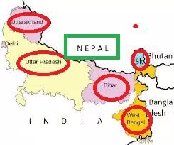
Which of the following states shares an international boundary? 

Detailed Solution for Test: India- Size And Location- 1 - Question 5

Uttar pradesh shares an international boundary with Nepal.

Test: India- Size And Location- 1 - Question 6

Assertion (A): Sri Lanka is separated from India by the Palk Strait.

Reason (R): Sri Lanka is located to the south of India.

Detailed Solution for Test: India- Size And Location- 1 - Question 6

Let's analyze both statements:

  • Assertion (A) is true: Sri Lanka is indeed separated from India by the Palk Strait.
  • Reason (R) is also true: Sri Lanka is located to the south of India.

However, the reason that Sri Lanka is located to the south of India is not the explanation for why it is separated from India by the Palk Strait. The Palk Strait is a specific geographical feature that separates the two countries, independent of their relative locations.

Therefore, the correct option is: If both Assertion and Reason are true but Reason is not the correct explanation of Assertion.

Test: India- Size And Location- 1 - Question 7

Standard meridian of India is __________________.

Detailed Solution for Test: India- Size And Location- 1 - Question 7

The standard meridian of India is 82°30'E. It passes through Mirzapur (Uttar Pradesh). The time of this meridian is taken as the standard time for the whole country.

Test: India- Size And Location- 1 - Question 8

Since the opening of the Suez Canal in 1869, India’s distance from Europe has been reduced by 7000 km.

Detailed Solution for Test: India- Size And Location- 1 - Question 8

Because, before the opening of Suez Canal, to reach Europe one had to cover almost half the east and whole of west coast of African continent taking a round through the Cape of Good Hope.

Test: India- Size And Location- 1 - Question 9

What geographical features have played a key role in promoting unity and homogeneity in Indian society?

Detailed Solution for Test: India- Size And Location- 1 - Question 9

The geographical features of lofty mountains in the north acting as a natural barrier against intrusions and the seas/ocean in the south shielding the land, have historically facilitated the assimilation of cultural elements into Indian society, promoting unity and homogeneity.

Test: India- Size And Location- 1 - Question 10
Choose the correctly matched pair.
Detailed Solution for Test: India- Size And Location- 1 - Question 10
  • Option A: (a) The Suez sea route - Connects Australia and Europe:
    • Explanation: This is incorrect. The Suez sea route provides the shortest route to industrial Europe and America, not specifically connecting Australia and Europe.
  • Option B: (b) Indian Ocean - Third-largest ocean in the world
    • Correct: The Indian Ocean is indeed the third-largest ocean in the world.
  • Option C: (c) East Africa - East of the Indian subcontinent
    • Incorrect: East Africa is located to the west of the Indian subcontinent.
  • Option D: (d) Upanishads - Modern Indian literature
    • Incorrect: The Upanishads are ancient Indian texts that are part of the Vedas, not modern Indian literature. Therefore, the correctly matched pair is Option B: (b).
53 videos|437 docs|80 tests
Information about Test: India- Size And Location- 1 Page
In this test you can find the Exam questions for Test: India- Size And Location- 1 solved & explained in the simplest way possible. Besides giving Questions and answers for Test: India- Size And Location- 1, EduRev gives you an ample number of Online tests for practice
53 videos|437 docs|80 tests
Download as PDF