UPSC Exam  >  UPSC Tests  >  Geography for UPSC CSE  >  Test: Drainage - 2 - UPSC MCQ

Test: Drainage - 2 - UPSC MCQ


Test Description

20 Questions MCQ Test Geography for UPSC CSE - Test: Drainage - 2

Test: Drainage - 2 for UPSC 2024 is part of Geography for UPSC CSE preparation. The Test: Drainage - 2 questions and answers have been prepared according to the UPSC exam syllabus.The Test: Drainage - 2 MCQs are made for UPSC 2024 Exam. Find important definitions, questions, notes, meanings, examples, exercises, MCQs and online tests for Test: Drainage - 2 below.
Solutions of Test: Drainage - 2 questions in English are available as part of our Geography for UPSC CSE for UPSC & Test: Drainage - 2 solutions in Hindi for Geography for UPSC CSE course. Download more important topics, notes, lectures and mock test series for UPSC Exam by signing up for free. Attempt Test: Drainage - 2 | 20 questions in 20 minutes | Mock test for UPSC preparation | Free important questions MCQ to study Geography for UPSC CSE for UPSC Exam | Download free PDF with solutions
Test: Drainage - 2 - Question 1

Which of the following is the result of concern over rising pollution in our rivers?

Detailed Solution for Test: Drainage - 2 - Question 1

The Government of India and many concerned state governments have started implementing various programmes to deal with the problems arising out of river pollution. They have made action plans and are vigorously implementing these plans.

Test: Drainage - 2 - Question 2

Which of the following affects the self-cleansing capacity of the river?

Detailed Solution for Test: Drainage - 2 - Question 2

The self cleansing capacity of a river refers to the natural ways in which the river gets rid of the pollutants discharged into it. The flow of the river, the presence of bacteria which decompose the pollutants and make them into harmless substances, are some factors which contribute to the self cleansing capacity of the river. But this can work to a certain limit only. Natural processes can help to keep the river clean to a certain extent but they cannot overcome uncontrolled pollution.

1 Crore+ students have signed up on EduRev. Have you? Download the App
Test: Drainage - 2 - Question 3

Why have the river banks attracted settlers from ancient times?

Detailed Solution for Test: Drainage - 2 - Question 3

The correct option is Option D.

Rivers have been of fundamental importance throughout human history. Water from the rivers is a basic natural resource, essential for various human activities. The river banks have attracted settlers from ancient times. These settlements have also become big cities, that is why rivers are considered the lifelines of human civilization.

Test: Drainage - 2 - Question 4

Which of the following is an artificial lake located in Andhra Pradesh?

Detailed Solution for Test: Drainage - 2 - Question 4

Nagarjuna Sagar Dam is one of the world's largest and tallest Masonry dams built across the Krishna river at Nagarjuna Sagar which straddles the border between Nalgonda District, Telangana State, India and Guntur district, Andhra Pradesh State, India. Constructed between 1955 and 1967, the dam created a water reservoir with gross storage capacity of 11.472 billion cubic metres (405.1×10⁹ cu ft). The dam is 590 feet (180 m) tall from its deepest foundation and 0.99 miles (1.6 km) long with 26 flood gates which are 42 feet (13 m) wide and 45 feet (14 m) tall.

Nagarjuna Sagar was the earliest in a series of large infrastructure projects termed as "modern temples" initiated for achieving the Green Revolution in India. It is also one of the earliest multi-purpose irrigation and hydro-electric projects in India. The dam provides irrigation water to the Nalgonda, Suryapet, Krishna, Khammam, West Godavari, Guntur and Prakasam districts along with hydro electricity generation. Nagarjuna Sagar dam is designed and constructed to use all the water impounded in its reservoir of 312 TMC gross storage capacity which is the second biggest water reservoir in India.

Test: Drainage - 2 - Question 5

Which one of the following is a lake created by human beings?

Detailed Solution for Test: Drainage - 2 - Question 5

Option C - Gobind Sagar is a reservoir created by human beings in honour of Guru Gobind Singh. This reservoir is located on Sutlej river in the Bilaspur district of Himachal Pradesh. It is also one of the world’s highest gravity dams

Test: Drainage - 2 - Question 6

Which one of the following freshwater lakes is the largest?

Detailed Solution for Test: Drainage - 2 - Question 6

Wular Lake (also spelt Wullar) is one of the largest fresh water lakes in Asia. It is sited in Bandipora district in the Indian state of Jammu and Kashmir. The lake basin was formed as a result of tectonic activity and is fed by the Jhelum River.

Test: Drainage - 2 - Question 7

Where does the Tapi river rise -      

Detailed Solution for Test: Drainage - 2 - Question 7

Tapi river rises near Multai in the Betul district of Madhya Pradesh at an elevation of about 752 m and flows for about 724 km before outfalling into the Arabian Sea through the Gulf of Cambay.

Test: Drainage - 2 - Question 8

Where are most of the freshwater lakes located ?       

Detailed Solution for Test: Drainage - 2 - Question 8

India's most freshwater lakes are found in the Himalayan region. Because they are of glacial origin which means that they were formed when glaciers dug out a basin which was later filled with snow melt.

Test: Drainage - 2 - Question 9

"The river rises in Tibet, near lake Manasarovar and flows into Arabian Sea". Identify the river

Detailed Solution for Test: Drainage - 2 - Question 9
Indus River originates near Manasarovar Lake from Mount Kailash of China. It flows through Leh in India and later through Pakistan before emptying into the Arabian Sea. Its major tributaries are divided into 2 groups. Panjnad includes the famous Ravi, Chenab, Jhelum, Beas and Sutlej.
Test: Drainage - 2 - Question 10

"On reaching the Namcha Barwa (7757 m) the river takes a 'U' turn and enters India in Arunachal Pradesh through a gorge". Identify the river -           

Detailed Solution for Test: Drainage - 2 - Question 10
The Brahmaputra originates in the Mansarovar lake, also the source of the Indus and the Satluj. It is slightly longer than the Indus, but most of its course lies outside India. It flows eastward, parallel to the Himalayas. Reaching Namcha Barwa (7757 m), it takes a U-turn around it and enters India in Arunachal Pradesh and known as dihang. The undercutting done by this river is of the order of 5500 metres. In India, it flows through Arunachal Pradesh and Assam, and is joined by several tributaries.
Test: Drainage - 2 - Question 11

Which of the following rivers has a braided Channel?

Detailed Solution for Test: Drainage - 2 - Question 11

Brahmaputra is a braided river because it one of the number of channel type and has a channel which consists of network of small channels which are separated by small islands which braids.

Test: Drainage - 2 - Question 12

Which of the following pair of rivers flow west and make esturies ?           

Detailed Solution for Test: Drainage - 2 - Question 12

Answer:


Pair of rivers: Narmada and Tapi


Direction of flow: West


Formation: Estuaries


Explanation:


The correct pair of rivers that flow west and make estuaries is Narmada and Tapi. Here's a detailed explanation:


Narmada River:


  • Originates in the Amarkantak Hills in Madhya Pradesh, India.

  • Flows westwards and forms an estuary where it meets the Arabian Sea in Gujarat, India.

  • The Narmada estuary is known as the Gulf of Khambhat.

  • The Narmada River is the fifth-largest river in the Indian subcontinent.


Tapi River:


  • Originates in the Betul district of Madhya Pradesh, India.

  • Flows westwards and forms an estuary where it meets the Arabian Sea in Gujarat, India.

  • The Tapi estuary is known as the Gulf of Khambhat.

  • The Tapi River is the second-longest river in Gujarat, India.


Therefore, the correct answer is option A: Narmada and Tapi. These rivers flow westwards and form estuaries where they meet the Arabian Sea.

Test: Drainage - 2 - Question 13

"The river rises in the Amarkantak hills in Madhya Pradesh and flows towards the west in a rift valley formed due to faulting". Identify the river -           

Detailed Solution for Test: Drainage - 2 - Question 13
The drainage basins of the peninsular rivers are comparatively small in size. The Narmada rises in the Amarkantak hills in Madhya Pradesh. It flows towards the west in a rift valley formed due to faulting.

Test: Drainage - 2 - Question 14

Which of the following rivers is known as the 'Dakshin Ganga' ?           

Detailed Solution for Test: Drainage - 2 - Question 14

The Godavari flows from North to South in Dharmapuri, hence the river is locally called 'Dakshina Vahini' Kaleshwaram – Sri Kaleswara Mukhteswara Swamy Temple is situated here on the banks of Triveni sangamam of rivers Godavari and pranahita. 

Test: Drainage - 2 - Question 15

Which of the following rivers do not form delta ?
(i) Tapi
(ii) Narmada 
(iii) Yamuna
(iv) Ganga           

Detailed Solution for Test: Drainage - 2 - Question 15
  • Tapi River: This river does form a delta as it flows into the Arabian Sea.
  • Narmada River: Similar to the Tapi, the Narmada also flows into the Arabian Sea but does not form a significant delta due to its steep gradient.
  • Yamuna River: The Yamuna flows into the Ganges and does not form a delta where it meets the Ganges. However, it contributes to the delta formed by the Ganges at the Bay of Bengal.
  • Ganga River: The Ganga forms a large delta known as the Sundarbans when it meets the Bay of Bengal.
Test: Drainage - 2 - Question 16

Which one of the following describes the drainage patterns resembling the branches of a tree ?           

Detailed Solution for Test: Drainage - 2 - Question 16
Dendritic or tree-shaped drainage pattern is the most common and widespread pattern to be found on the earth’s surface. The pattern is called dendritic on the ground that the network of tributaries of various orders and magnitudes of the trunk or master stream resembles the branches and roots and rootlets of a tree.
Test: Drainage - 2 - Question 17

Which one of the following is the largest river of the Peninsular India?           

Detailed Solution for Test: Drainage - 2 - Question 17
The Godavri basin is the largest river basin in peninsular India. The Godavari is the second longest river in India after the river Ganga. It starts in Maharashtra and flows for 1,465 kilometres (910 mi) into the Bay of Bengal via the states of Telangana and Andhra Pradesh. It forms one of the largest river basins in India.

Test: Drainage - 2 - Question 18

Which one of the following rivers flows through a rift valley?           

Detailed Solution for Test: Drainage - 2 - Question 18

The Narmada, also called the Rewa, is a river in central India and the fifth longest river in the Indian subcontinent. It is the third longest river that flows entirely within India, after the Godavari, and the Krishna. It is one of only three major rivers in peninsular India that run from east to west (longest west flowing river), along with the Tapti River and the Mahi River. It is one of the rivers in India that flows in a rift valley, flowing west between the Satpura and Vindhya ranges. The other rivers which flow through rift valley include Damodar River in Chota Nagpur Plateau and Tapti. The Tapti River and Mahi River also flow through rift valleys, but between different ranges.

Test: Drainage - 2 - Question 19

Which one of the following rivers have Nagarjun Sagar Dam, a river valley project?           

Detailed Solution for Test: Drainage - 2 - Question 19

Nagarjuna Sagar Dam is a masonry dam across the Krishna river at Nagarjuna Sagar which straddles the border between Guntur district, Andhra Pradesh and Nalgonda district, Telangana.

Test: Drainage - 2 - Question 20

The area drained by a single river system is called a –           

Detailed Solution for Test: Drainage - 2 - Question 20

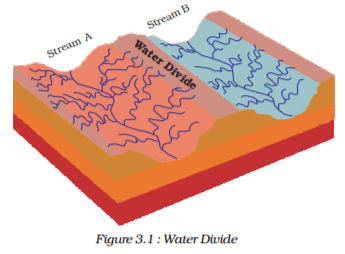
The term drainage describes the river system of an area. Look at the physical map. You will notice that small streams flowing from different directions come together to form the main river, which ultimately drains into a large water body such as a lake or a sea or an ocean. The area drained by a single river system is called a drainage basin. A closer observation on a map will indicate that any elevated area, such as a mountain or an upland, separates two drainage basins. Such an upland is known as a water divide (Figure 3.1).


180 videos|475 docs|195 tests
Information about Test: Drainage - 2 Page
In this test you can find the Exam questions for Test: Drainage - 2 solved & explained in the simplest way possible. Besides giving Questions and answers for Test: Drainage - 2, EduRev gives you an ample number of Online tests for practice

Top Courses for UPSC

180 videos|475 docs|195 tests
Download as PDF

Top Courses for UPSC