The Earth and its atmosphere Chapter Notes | Year 7 Physics (Cambridge) - Class 7 PDF Download
| Table of contents |

|
| Introduction |

|
| The Earth's Crust |

|
| Earthquake, Volcanoes and mountains |

|
| The Earth's Atmosphere |

|
| The Water Cycle |

|
Introduction
The Earth is surrounded by a layer of gases called the atmosphere. This thin layer of gases protects life on Earth by providing warmth, absorbing harmful solar radiation, and maintaining a stable climate.
The atmosphere is made up of several layers, each with its own unique characteristics and functions. Understanding the Earth's atmosphere helps us comprehend weather patterns, climate change, and the impact of human activities on our planet.
The Earth's Crust
Earth's crust is the thinnest of all the layers that make up the planet. Imagine peeling a hard-boiled egg for a moment. The yolk and the egg whites make up nearly all of the egg, with an extremely thin shell that surrounds those edible insides.
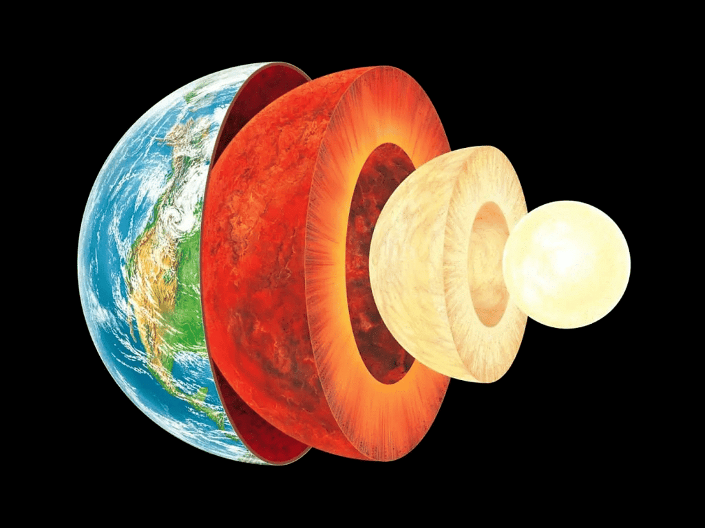
The Earth is constructed very much like this egg, and the shell represents Earth's crust. It is very, very thin compared to the other layers! Of course, there are very obvious differences between an eggshell and the Earth's crust
Inside the Earth
The Earth is a sphere with a radius of 6371 km. The ground beneath you is part of the Earth's crust. The thickness of the crust varies:
- On land, the crust is 25-90 km thick.
- Under the oceans, the crust is 5-10 km thick.
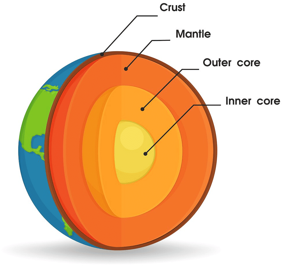 The structure of the Earth
The crust is made of solid rock. Beneath the crust is the mantle, a much thicker layer of hot rock. The mantle is hot enough to flow, but it is sticky and slow. Inside the mantle is the Earth's core. Scientists think the center of the core is solid and made from iron and nickel, while the outer core is liquid.
The Movement of the Crust
Continental Drift Theory
- When we look at a photograph of the Earth from space, we see large areas of land called continents surrounded by water in the oceans. In the 1600s, as people explored the world, map makers noticed that the shapes of two continents separated by an ocean appeared to match. In the late 1700s, German biologist Alexander von Humboldt suggested that the continents around the Atlantic Ocean had been joined together millions of years ago.
In 1912, another German scientist, Alfred Wegener, proposed his hypothesis of continental drift. Wegener said that millions of years ago, all the continents we know today were joined together in a 'supercontinent' called Pangaea. Over time, the continents gradually moved apart. Wegener found evidence to support his hypothesis:
- The coasts of continents contained layers of different types of rock, and the patterns of layers in distant continents matched.
- The arrangement of climate zones has changed over time, as shown by rock layers and fossils found in them, supporting Wegener's hypothesis.
- Identical fossils of animals that could not fly or swim long distances were found in South America, Africa, India, and Australia, suggesting these continents were once connected.
However, Wegener could not explain what caused the continents to move, and his explanations were disproven by other scientists. Many scientists opposed his ideas, with one stating at a conference, 'If we are to believe Wegener's hypothesis, we must forget everything which has been learned in the last 70 years and start all over again'.
Tectonic Plate
- In the 1950s, scientists were investigating the patterns of magnetism in rocks on different continents. Their measurements showed how the position of the Earth's magnetic north pole had changed over time. If the continents had always been in the same place, their measurements suggested there must have been multiple magnetic north poles on Earth simultaneously, which didn't make sense. The only explanation that did make sense was Wegener's theory of continental drift, which showed how a single magnetic north pole that slowly changed position, as well as continents moving apart over time, could result in the observed magnetic patterns.
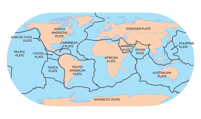 Map of main plates around the globe and their direction of movement.
 - This realization prompted many scientists to take Wegener's hypothesis more seriously. They re-examined his scientific papers, analyzed his conclusions through peer review, and looked for more evidence. By the 1960s, they developed an explanation now accepted by most scientists: the theory of plate tectonics.
The theory of plate tectonics states:
- The Earth's hard crust is divided into separate pieces called tectonic plates.
- Each plate 'floats' on the flowing mantle underneath and moves very slowly due to the mantle's flow.
- In some areas, two plates move apart, creating a gap through which hot, molten rock rises to the surface and cools, forming new crust.
- In other areas, two plates push together. Sometimes one plate is pushed under the other (subduction), causing the upper plate to rise. Sometimes both plates push against each other, forming mountain ranges through folding.
Earthquake, Volcanoes and mountains
Earthquakes are sudden movements of parts of the Earth's crust. Volcanoes are found at breaks in the Earth's crust. Friction is a force created between surfaces when they move against each other.
Plate Boundaries
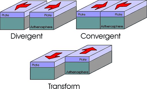
The theory of plate tectonics tells us that sections of the Earth's crust are moving very slowly. The places where two plates meet are called plate boundaries. A number of different things may happen at these boundaries:
- Two plates may move apart (figure 10.5a). As the plates move, a gap appears between them. Hot rock from the mantle flows upwards to fill the gap. The rock cools and forms new crust.
- Two plates may move towards each other, with two possible results. Sometimes, one plate rises up above the other plate, which is pushed downwards (figure 10.5b). Eventually, the rock pushed down heats up and forms part of the mantle. This piece of crust is destroyed.
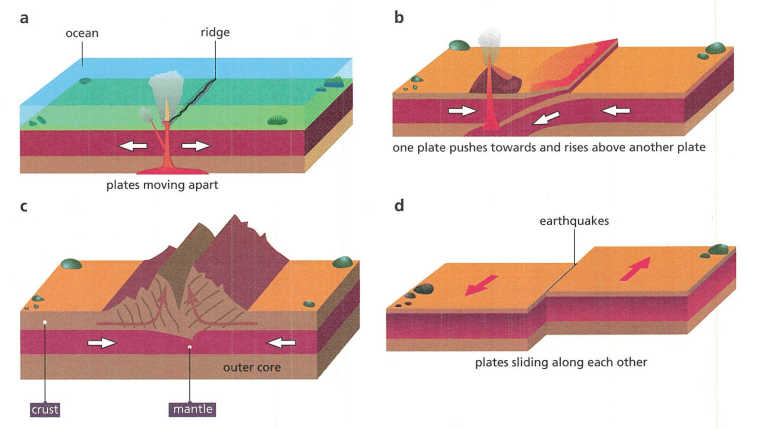 Types of boundaries between tectonic plates.
 - Two plates moving towards each other may also simply collide (figure 10.5c). The edges of both plates are pushed upwards.
- Two plates may slide past each other (figure 10.5d). No new crust is formed.
The movement of plates at plate boundaries is usually very slow (on average, between 2.5 cm and 15 cm per year). However, large forces can build up at plate boundaries that can cause earthquakes and volcanoes. These forces can also cause mountains to form. Plate tectonics provides explanations for all these observed phenomena.
However, plate tectonics is not a perfect theory; it has limitations. For example, it relies on the idea that sticky, molten rock in the mantle rises up in some places, pushes the plates sideways, and then sinks back down towards the centre of the Earth. The crust is so thick that scientists cannot yet drill deep enough to observe and measure this movement of rock. Also, these movements require a very large amount of energy, but scientists cannot yet show how the molten rock in the mantle provides enough energy to create mountains.
Earthquakes
Where two plates slide past each other, the edges of solid rock can stick together (figure 10.6a). Over time, a large force builds up. Eventually, the force becomes so large that the rock plates suddenly slip and the edges move several meters in a few seconds. This releases a large amount of energy, causing the ground to shake up and down or from side to side, which we call an earthquake.
Earthquakes can also occur away from plate boundaries, though less often. These are caused by the movement of tectonic plates over millions of years, which can create cracks and weaken parts of the crust, known as fault lines. Sections of crust can move suddenly along these cracks to cause earthquakes. The cause of earthquakes
Scientists have set up systems to detect vibrations from earthquakes worldwide. These vibrations travel through the crust and mantle. By collecting data, scientists can predict where earthquakes are most likely to occur. However, predicting exactly when an earthquake might happen is very difficult. Scientists can identify when forces are building up along a plate boundary, but not when these forces will cause a sudden movement.
We can also predict the effects of earthquakes. For example, an earthquake under an ocean can release energy into the water, causing a huge wave called a tsunami. Predicting when and where earthquakes will occur and how strong they might be is challenging due to the size of Earth's tectonic plates and the limitations of our models:
- Supercomputers are needed to collect and process all the data.
- Even tiny changes in the data can significantly affect predictions.
- We lack data about the mantle beneath the tectonic plates, so assumptions must be made about its behavior.
Volcanoes
Volcanoes form where hot, molten rock called magma breaks through the Earth's crust to flow over the surface. They can form wherever there are weak spots in the crust or where the movement of tectonic plates at a plate boundary causes forces that melt rock.
- Where plates move apart, this leaves a weak spot in the Earth's crust at the plate boundary, forming a 'crack' called a rift valley. Hot rock rises and can break through the crust, filling the gap. These boundaries are mostly found under oceans. An example is Iceland, where volcanoes have formed an island.
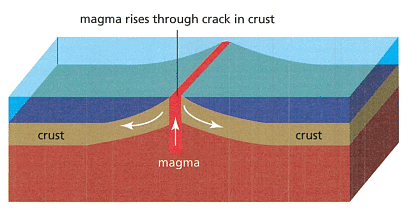 The cause of Volcanoes at a plate boundary where the plates are moving apart
- Where plates move together and one plate is pushed beneath the other, large forces can heat up the rock. These 'hot spots' of liquid rock push upwards and can break through to the surface, forming a line of volcanoes. The western coast of South America is an example of this.
Mountains
- When two tectonic plates meet and one is forced beneath the other, the edge of the upper plate rises, leading to the formation of mountains.
- Not all mountains formed this way are volcanoes. Another scenario involves two plates colliding, causing both plate edges to rise.
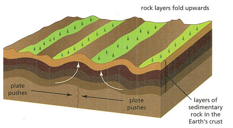 Cross-Section of fold mountains forming
Plate boundaries are commonly located under oceans. Over millions of years, layers of sedimentary rock are created as dead organisms accumulate on the seafloor.
- If the plates collide or one sinks below the other, the sedimentary rock gets trapped between them. As mountains form, these layers of rock are pushed upwards, appearing folded, hence termed fold mountains.
- Examples of fold mountains are the Himalayas in Asia, the Rocky Mountains in North America, and the Andes in South America.
The Earth's Atmosphere
Earth's atmosphere comprises a blend of various gases, where the presence of water vapor can vary based on temperature and weather conditions. Further insights on this topic will be covered in Stage 8. For now, let's focus on 'dry air,' which does not contain water.
Measuring Gas Composition
- Quantifying gas proportions in the atmosphere involves conducting experiments. One such procedure is depicted in figure 10.18.
- A gas syringe, holding 100 cm3 of dry air, links to a receptacle suitable for chemical reactions.
- Inside this receptacle lies numerous minute fragments of dry, unadulterated copper metal.
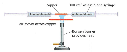 Two Syringes connected to a reaction container for measuring the oxygen in air
- Upon heating the reaction container, air gradually displaces from the gas syringe, passing over the copper.
- The unaltered gases collect in a secondary gas syringe.
Copper and Oxygen Interaction
- In this experimental setup, copper interacts solely with oxygen from the air sample.
- Other gases within the sample do not undergo reactions with copper.
- The resultant product of this reaction is solid copper oxide.
- The quantity of copper oxide generated indicates the oxygen content in the original air sample.
Changes in the Atmosphere Over Time
- Earth's atmosphere has varied in composition over time. Approximately 4.5 billion years ago, there was significantly less oxygen and more carbon dioxide present.
- The early Earth had numerous volcanoes emitting gases rich in sulfur, contributing to the atmospheric changes.
- Natural processes spanning millions of years gradually altered gas proportions in the atmosphere, with the emergence of life playing a pivotal role.
- The earliest life forms survived in hot conditions using substances like sulfur and carbon for energy.
- As the Earth cooled, around 2.7 billion years ago, primitive bacteria evolved, absorbing carbon dioxide and producing oxygen.
- Approximately 700 million years ago, the first true plants emerged, enhancing oxygen production and reducing carbon dioxide levels.
- Oceanic processes also influence atmospheric gas composition. Ocean waters absorb carbon dioxide, which is trapped when freezing occurs in polar regions, lowering atmospheric carbon dioxide levels.
- Natural emissions from processes like volcanic eruptions and methane production by animals impact atmospheric composition.
- Carbon dioxide, despite being a minor component, significantly affects the atmosphere as a greenhouse gas, regulating heat retention.
- Increased carbon dioxide levels intensify heat retention, leading to global warming and subsequent environmental consequences.
The Role of Human Activities
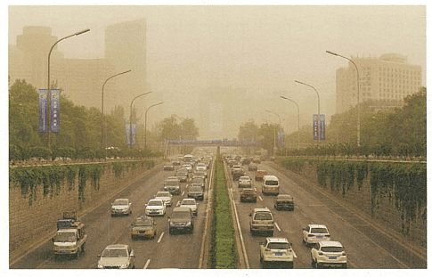
- Human actions contribute to atmospheric changes by releasing pollutants such as carbon dioxide from burning fuels like coal and diesel.
- Emissions from human activities, including solid particles from combustion, can lead to air pollution, respiratory issues, and potential health risks.
- Visible manifestations of pollution, like smog resulting from the interaction of gases and smoke with fog, signify human impact on atmospheric quality.
The Water Cycle
On Earth, water evaporates, condenses and precipitates (falls as rain) .The formation and erosion of different types of I Use models, including diagrams, to describe rock form a rock cycle
Water Cycle
- Evaporation: Water particles at the surface of a lake or ocean gain energy to break free, becoming water vapour in the atmosphere.
- Condensation: Water particles in the air lose energy and gather to form droplets of liquid water, leading to cloud formation.
- Precipitation: Water droplets in the air grow large enough to fall as liquid or solid water to the ground or ocean surface.
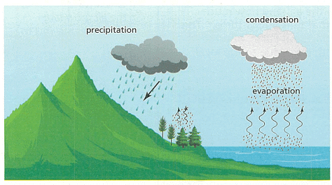
Evaporation from the ocean increases when warm air blows across the water surface. Winds carry the water vapour across the ocean and sometimes over land. As the warm air rises, it cools, leading to condensation. Warm, wet air blown over mountains cools quickly, forming clouds.
The type of precipitation depends on the air temperature:
- If above 0°C, water droplets form rain.
- If at or below 0°C, droplets freeze to form sleet, snow, or hail.
Dry air is air that contains no water. In reality, nearly all air contains some water vapour. The amount of water vapour depends on evaporation and condensation, varying by location and time due to local climate and weather.
Water that Falls on the Surface of Earth
Some of the water that falls as precipitation ends up back in places of open water such as oceans, freshwater lakes, and rivers. However, some precipitation falls on land and goes through one or more processes:
- Groundwater: Some water moves into the ground, draining through cracks in rocks or soaking through the air spaces between soil particles. This unseen water is called groundwater.
- Water Run-off: Some water gathers and flows over the ground. Before this moving water reaches a stream or river, it is known as water run-off (or surface run-off).
Both groundwater and water run-off move from higher to lower ground because of gravity. Groundwater moves lower in the ground, while water run-off moves sideways and downwards.
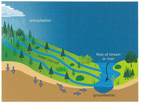 Groundwater and water run-off
Some precipitation falls as snow or hail, mostly on high ground that remains cold for most of the year:
- During spring, rising ground temperatures cause snow to melt, forming streams and rivers as part of water run-off.
- In high areas where temperatures remain below 0°C, snow forms solid ice, creating glaciers. In spring, part of the glacier ice melts to form streams and rivers, also part of water run-off.
Eventually, most precipitation that falls on land returns to the oceans. Open water, groundwater, and water run-off are all part of the larger water cycle. Water evaporates from the ocean, forms clouds, and falls as precipitation onto land or ocean. Water on land moves back to the ocean through groundwater and water run-off.
Figure 10.24 shows the different parts of the water cycle. The water cycle is an example of a model. While it's not possible to fully represent the water cycle in a school lab, you can investigate some of the different processes involved on a small scale.
|
14 videos|31 docs|9 tests
|
FAQs on The Earth and its atmosphere Chapter Notes - Year 7 Physics (Cambridge) - Class 7
| 1. What are the different layers of the Earth's crust? |  |
| 2. How are earthquakes formed and what causes them? |  |
| 3. What is the relationship between volcanoes and mountains? |  |
| 4. How does the Earth's atmosphere protect life on Earth? |  |
| 5. What is the importance of the water cycle to the Earth's ecosystem? |  |


