Class 7 Social Science Chapter 8 Let's Explore - How the Land Becomes Sacred
| Table of contents |
|
| Page 168: What is ‘Sacredness’? |
|
| Page 171: Pilgrimages |
|
| Page 173 & 174 : Becoming Aware of Sacred Geography |
|
| Page 181: From pilgrimage to trade |
|
| Page 177,179 & 182: Think About it |
|

Page 168: What is ‘Sacredness’?
Q: Do any of the pictures look familiar to you? Can you name similar places found in your neighbourhood?
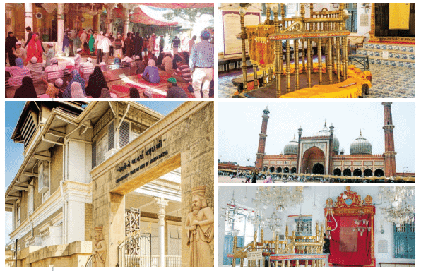 Fig. 8.2
Ans: Students should observe the pictures (e.g., Fig. 8.2) and identify similar sacred sites in their locality. For example, a nearby temple, mosque, church, or river considered holy could be mentioned.
Example: "The shrine in the picture resembles [Local Temple Name] in my neighbourhood, visited during festivals for prayers."
Page 171: Pilgrimages
Q: Read the excerpt. What are your observations? Locate the route the group must have taken from Rameswaram to Haridwar. Why do you think the group was going straight to Haridwar instead of stopping at Delhi?
Ans: Observations: The excerpt describes pilgrims from near Lucknow who traveled to Rameswaram for three months and are now heading to Haridwar without stopping in Delhi. They carried food essentials, showing self-reliance, and their urgency suggests a fixed religious schedule.
Route: Rameswaram → Madurai → Chennai → Vijayawada → Nagpur → Bhopal → Gwalior → Delhi → Haridwar (via trains like Tamil Nadu Express, then a short Delhi-Haridwar leg).
Reason: The group prioritized Haridwar, a major tirtha on the Ganga, over Delhi, which is a transit hub but not a primary sacred site. Their response, "We don’t have time," indicates a need to complete the pilgrimage due to time constraints or responsibilities.
Q: In ancient times, when people were travelling from Madurai in Tamil Nadu to Varanasi in Uttar Pradesh, what languages would they come across? How would they communicate with people in those places? Where would they stay? What food would they eat?Ans: Languages: Tamil (Tamil Nadu), Telugu (Andhra Pradesh), Marathi (Maharashtra), Hindi/Bhojpuri (Madhya Pradesh, Uttar Pradesh), possibly Kannada or Odia.
Communication: Used gestures, basic local phrases, or Sanskrit (among priests). Guides or shared vocabularies from trade routes helped.
Accommodation: Dharmashalas, temples, homes of devotees, or camps under trees.
Food: Carried atta, ghee, sugar; ate vegetarian meals (roti, dal, rice) from temples, langars, or local produce (fruits, milk), adapting to regional cuisines.
Page 173 & 174 : Becoming Aware of Sacred Geography
Q: Note the locations of the char dham. What do you think it implied for the people when they travelled north-south and east-west?Ans: Locations: Badrinath (Uttarakhand, North), Puri (Odisha, East), Rameswaram (Tamil Nadu, South), Dwarka (Gujarat, West).
Implications:
- Cultural Unity: Exposed pilgrims to diverse languages, foods, and customs, highlighting shared Hindu practices, fostering a pan-Indian identity.
- Geographical Link: Connected India’s extremities, embedding the idea of a unified sacred land.
- Economic Boost: Interactions with traders along routes spurred local economies.
- Spiritual Quest: Arduous travel symbolized inner growth, deepening devotion.
Q: Can you identify the names of a few traditional tirthas given in the map above? You can refer to the political map at the end of the book for help.
Ans: Based on the document, likely tirthas on the map (Fig. 8.6) include:
- Badrinath (Uttarakhand): Vishnu’s Char Dham.
- Puri (Odisha): Jagannath Temple, Char Dham.
- Rameswaram (Tamil Nadu): Char Dham, Jyotirlinga.
- Varanasi (Uttar Pradesh): Shiva’s tirtha on the Ganga.
- Haridwar (Uttarakhand): Kumbh Mela site.
Students can verify locations using a political map.
Page 181: From pilgrimage to trade
Q: Take a sheet of transparent paper that can be used for tracing. Trace a map of the trade routes from the chapter 'The Rise of Empires'. Place it on top of the map of the important tirthas. What do you observe?
Ans: Process: Trace trade routes (Fig. 5.5) like Uttarapatha (Taxila to Pataliputra via Varanasi) and Dakshinapatha (Kaushambi to Paithan via Ujjain). Overlay on tirtha map (Fig. 8.6).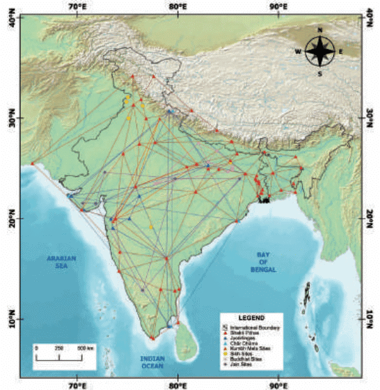 Fig. 8.6. A map showing a few networks of traditional tīrthas
Observations:
- Tirthas like Varanasi, Ujjain, and Mathura align with trade routes, showing overlap.
- Pilgrims and traders used the same routes, facilitating goods exchange (e.g., spices, textiles) and cultural interactions.
- Tirthas at river confluences (e.g., Prayagraj) were trade hubs, enhancing their economic and religious significance.
Page 177,179 & 182: Think About it
Q: How do you think these sacred places are connected with the people's economic lives and activities? Draw a mind map to trace these connections. (Hint: The pictures above can provide some clues.)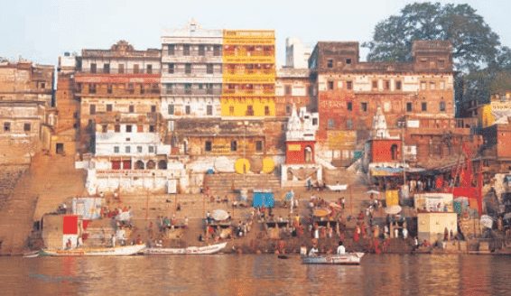
Ans: Connections:
- Tourism: Pilgrims support hotels, eateries, and transport (e.g., boats in Varanasi).
- Trade: Markets near tirthas sell idols, offerings, and crafts.
- Employment: Priests, guides, vendors, and artisans depend on pilgrimage.
- Agriculture: Pilgrims buy local produce, boosting farmers during festivals.
- Infrastructure: Tirthas attract investment in roads and facilities, creating jobs.
Q: Many parts of the peepul tree have medical uses: the leaves are used to treat some skin ailments while the bark is useful for stomach ailments. Since it stays green almost through the year, it provides food and shelter to many types of birds and other animals.
Ans: Medicinal Uses: Leaves treat skin issues (e.g., eczema); bark aids digestion (e.g., diarrhea).
Ecological Role: Evergreen foliage provides shade, habitat for birds (e.g., mynas), and fruits for seed dispersal, supporting biodiversity.
Cultural Impact: Its utility reinforces its sacred status in Hinduism, Buddhism, Jainism, and Sikhism, encouraging conservation near temples.
Q: Look carefully at these pictures of places and animals that are considered sacred. The Yamuna in the north, the Mahanadi in the east, or the Kaveri in the south are all sacred rivers. How come they have become so polluted? Are there sacred places in your locality or region that have been similarly polluted or degraded by human activity? Whose responsibility is it to preserve the sanctity of our sacred places? Discuss in class.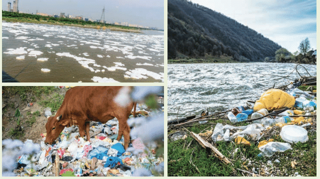
Ans: Pollution Causes:
- Industrial effluents (e.g., Yamuna in Delhi).
- Urban sewage (e.g., Mahanadi in Bhubaneswar).
- Ritual offerings (flowers, idols) during festivals.
- Lack of awareness about ecological impact.
- Weak enforcement of pollution laws.
- Local Examples: E.g., a temple pond with plastic waste or a littered sacred hill. Example: "A local river near my town is polluted with garbage from festivals."
Responsibility:
- Individuals: Use biodegradable offerings, avoid plastic.
- Communities: Organize clean-ups, raise awareness.
- Government: Enforce laws, fund projects like Namami Gange.
- Religious Leaders: Promote sustainable rituals.
- Collective: Constitution (Article 51A) mandates environmental protection.
|
23 videos|204 docs|12 tests
|
FAQs on Class 7 Social Science Chapter 8 Let's Explore - How the Land Becomes Sacred
| 1. What does it mean for land to be considered sacred? |  |
| 2. How can land become sacred over time? | |
| 3. What role do rituals play in making land sacred? | |
| 4. Why is it important to preserve sacred lands? | |
| 5. How do different cultures define and recognize sacred land? | |


Class 7 Social Science Chapter 8 Let's Explore - How the Land Becomes Sacred
,Previous Year Questions with Solutions
,Extra Questions
,shortcuts and tricks
,Free
,Class 7 Social Science Chapter 8 Let's Explore - How the Land Becomes Sacred
,Viva Questions
,Objective type Questions
,Exam
,video lectures
,mock tests for examination
,past year papers
,practice quizzes
,Semester Notes
,MCQs
,study material
,Summary
,Class 7 Social Science Chapter 8 Let's Explore - How the Land Becomes Sacred
,Important questions
,Sample Paper
,ppt
;


Let's Explore: How the Land Becomes Sacred Free PDF Download
Importance of Let's Explore: How the Land Becomes Sacred
Let's Explore: How the Land Becomes Sacred Notes
Let's Explore: How the Land Becomes Sacred Class 7 Questions
Study Let's Explore: How the Land Becomes Sacred on the App
|
© EduRev
|
Education Revolution
|


|


