Environment and Ecology: August 2024 UPSC Current Affairs | Environment for UPSC CSE PDF Download

Ground-Level Ozone Pollution in India

A recent study by the Centre for Science and Environment (CSE) has highlighted the troubling levels of ground-level ozone (O3) in major Indian cities. This situation poses significant health risks, particularly for vulnerable groups such as individuals with respiratory conditions.
What are the Key Findings of the Study?
High Ozone Exceedance in Major Cities:
- Delhi-NCR experienced 176 days of ground-level ozone exceedance from January 1 to July 18, 2023, the highest among all cities.
- Mumbai and Pune recorded 138 days each, while Jaipur had 126 days of exceedance.
- Unexpectedly, ozone levels remained elevated after sunset in many cities, with Mumbai noting 171 nights and Delhi-NCR 161 nights of exceedance.
- In comparison to the previous year, seven out of ten cities reported increased ozone exceedances, with Ahmedabad's levels soaring by 4,000%, followed by Pune (500% rise) and Jaipur (152% rise).
Standards and Measurement Issues:
- The established standard for ozone is 100 µg/m³ over eight hours and 180 µg/m³ for one hour.
- The Central Pollution Control Board's limitation of data at 200 µg/m³ complicates a comprehensive understanding of the severity of exceedances.
Health Risks:
- Exposure to ground-level ozone can lead to various respiratory issues, including chest pain, coughing, bronchitis, emphysema, and asthma.
- It can also cause inflammation and damage to lung tissue, potentially resulting in long-term health complications.
Green Areas Worst Affected:
- Surprisingly, affluent green neighborhoods have emerged as hotspots for ground-level ozone, challenging the idea that these areas are inherently safer in terms of air quality.
- Ozone accumulates in cleaner areas where there are fewer gaseous pollutants to react with.
Inverse Spatial Distribution:
- The distribution of ozone tends to be inversely related to nitrogen dioxide (NO₂) and particulate matter (PM2.5).
- Although ozone is formed in polluted regions, it tends to drift and concentrate in areas with lower NO₂ levels, making them more susceptible to higher ozone levels.
What is Ground-Level Ozone?
About:
- Ground-level ozone, also known as tropospheric ozone, is a secondary pollutant generated when nitrogen oxides (NOx) and volatile organic compounds (VOCs) from vehicles, factories, and power plants react under sunlight, with higher levels observed during summer months.
- This colorless gas forms just above the Earth's surface.
- Unlike the protective ozone layer in the stratosphere, which shields the Earth from harmful ultraviolet (UV) radiation, ground-level ozone is a harmful pollutant, often referred to as "bad ozone."
- Rising temperatures, particularly during heatwaves, exacerbate the formation of ground-level ozone, resulting in hazardous air quality in cities like New Delhi when ozone levels surpass permissible limits.
Impact:
- A notable increase in ozone-related mortality has been observed globally, with South Asia, including India, witnessing the most significant rise.
- Projections indicate that by 2050, over a million deaths in India could be associated with ozone exposure if emissions of precursor gases are not effectively managed.
- Ground-level ozone negatively impacts crop health, diminishing yields and seed quality.
- Essential crops like wheat and rice, staples in India, are particularly vulnerable to ozone pollution, which threatens food security.
Concerns for India:
- India houses 10 of the world's 15 most polluted cities, with air quality significantly exceeding World Health Organization (WHO) recommendations.
- The combination of poor air quality, rising temperatures, and frequent heatwaves heightens India's vulnerability to the detrimental effects of ground-level ozone.
- The country's growing and aging population faces increasing health risks from ozone pollution, likely leading to a greater public health burden as more individuals are exposed to this pollutant.
Challenge in Reducing Ground-Level Ozone:
- Unlike other air pollutants, ground-level ozone is part of a cyclical chemical process.
- Reducing precursor gases (NOx and VOCs) does not necessarily lead to a decrease in ozone levels; if conditions are not managed properly, ozone can persist in the atmosphere, resulting in prolonged exposure.
- Enhancing air quality monitoring and implementing alerts, as seen in Delhi, can help alleviate ozone pollution by notifying the public and industries when preventive measures are necessary.
World Biofuels Day 2024

World Biofuel Day is observed annually on August 10th to raise awareness about the significance of biofuels as an alternative to conventional fossil fuels. As we approach World Biofuel Day 2024, it is essential to understand the role biofuels play in reducing carbon emissions and promoting energy security. This day serves as a platform to highlight the advancements in biofuel technologies and the policies supporting their adoption globally and in India.
Why World Biofuel Day is Celebrated?
World Biofuel Day is celebrated annually on August 10th to raise awareness about the potential of biofuels as a sustainable alternative to conventional fossil fuels. The day aims to highlight the importance of biofuels in reducing greenhouse gas emissions, promoting energy security, and supporting rural development. It serves as a platform to educate the public and policymakers about the benefits of biofuels, encouraging the adoption of cleaner energy solutions.
- Observed On: August 10th
- 2024 Theme: “Sustainable Biofuels: Fueling a Greener Future”
- Focus on renewable energy sources derived from organic materials (e.g., ethanol, biodiesel, biogas)
- India’s National Biofuels Policy aims to promote biofuels in transportation with a target of 20% ethanol blending by 2025
- Ethanol Blended Petrol Programme: An initiative to blend ethanol with petrol to reduce oil imports and emissions
- E20 Fuel: A blend of petrol containing 20% ethanol and 80% gasoline
- Global Biofuel Alliance: An international coalition promoting global biofuel production and use
World Biofuel Day 2024 Theme
The theme for World Biofuel Day 2024 is “Sustainable Biofuels: Fueling a Greener Future.” This theme emphasizes the importance of developing and utilizing biofuels sustainably to ensure long-term environmental benefits. It highlights the need for innovation in biofuel production technologies and the adoption of policies that promote their widespread use.
Significance of World Biofuel Day
The significance of World Biofuel Day lies in its role in promoting sustainable energy practices. By focusing on biofuels, the day emphasizes the need to reduce reliance on non-renewable energy sources and mitigate climate change impacts.
- Promote Sustainable Energy: Encourages the transition from non-renewable to renewable energy sources.
- Climate Change Mitigation: Highlights the role of biofuels in reducing greenhouse gas emissions.
- Economic Benefits: Showcases job creation and support for rural economies through biofuel production.
- Agricultural Sustainability: Enhances the sustainability of agricultural practices.
- International Cooperation: Fosters global collaboration and innovation in biofuel technologies.
- Drive Global Efforts: Supports worldwide initiatives for a greener and more sustainable future.
What Are Biofuels?
Biofuels are fuels produced from organic materials such as plant and animal waste, intended to replace or supplement traditional fossil fuels like petrol and diesel. Common types of biofuels include ethanol, biodiesel, and biogas. Biofuels offer several advantages:
- Lower greenhouse gas emissions.
- Reduced dependence on oil imports.
- Support for agricultural and rural development.
Biofuel Production in India
The Indian government is committed to utilizing biofuels to decrease dependence on imported crude oil, achieve foreign exchange savings, provide better remuneration for farmers, address environmental issues arising from fossil fuel use and biomass burning, manage agricultural residues in accordance with the Swachh Bharat Abhiyan, and promote the “Make in India” campaign.
- India is currently the world’s third-largest producer and consumer of ethanol.
- The National Policy on Biofuels, released in 2018, set blending targets for ethanol (20% by 2030) and biodiesel (5% by 2030).
- As of November 30, 2023, India's ethanol production capacity is approximately 1,380 crore litres, with 875 crore litres from molasses and about 505 crore litres from grain sources.
Ethanol Blended Petrol (EBP) Programme
This initiative under India’s National Biofuels Policy aims to reduce the country’s reliance on imported crude oil and decrease greenhouse gas emissions. The EBP Programme blends ethanol derived from sugarcane molasses with petrol, showing steady progress in increasing the ethanol blending percentage annually.
What Is E20 Fuel?
E20 fuel refers to petrol that contains a blend of 20% ethanol and 80% gasoline. This is part of India’s strategy to enhance the usage of renewable energy sources in transportation. The benefits of E20 fuel include:
- Lower emissions.
- Reduced reliance on fossil fuels.
The successful implementation of E20 fuel is critical for meeting targets outlined in the Ethanol Blended Petrol Programme and the National Biofuels Policy.
Global Biofuel Alliance
The Global Biofuel Alliance is an international coalition dedicated to promoting the production and use of biofuels worldwide. The alliance aims to:
- Foster collaboration among countries.
- Share best practices and advance research in biofuel technologies.
- Enhance energy security, reduce carbon emissions, and promote sustainable development.
With initiatives like India’s National Biofuels Policy and the Global Biofuel Alliance, the future of biofuels appears promising, paving the way for a cleaner and greener world. Enroll in our UPSC PW Online Coaching to get expert and the best resources to prepare for UPSC Examination.
SIT Report on Tigers Deaths in MP

A Special Investigation Team (SIT) report has exposed significant problems in wildlife protection efforts in Madhya Pradesh. This comes in the wake of documented deaths of 43 tigers at Bandhavgarh Tiger Reserve and Shahdol Forest Circle between 2021 and 2023. The report highlights serious lapses in investigative processes, inadequate evidence collection, and a troubling lack of accountability among officials responsible for tiger conservation. These findings raise substantial concerns regarding the effectiveness of current measures aimed at safeguarding one of India’s most iconic wildlife species.
Investigation Shortcomings:
- The report points out that in at least 10 cases of tiger deaths, there was a lack of thorough investigation, resulting in only two arrests. This indifference from authorities has led to several cases where body parts were missing.
Forensic and Data Gaps:
- There is a significant absence of mobile forensics and electric trip data in incidents involving electrocution. Moreover, there is a lack of investigation into land ownership, which is crucial for addressing poaching issues.
Misattributed Causes of Death:
- There is a recurring trend of attributing tiger deaths to infighting without conducting thorough investigations, potentially obscuring cases of poaching.
Post-mortem Inadequacies:
- The report criticizes post-mortem procedures for poor sample collection and insufficient documentation.
Medical Negligence:
- Instances of medical negligence have been reported, such as failures to identify foreign objects during treatment, which have resulted in fatalities among tigers.
- The National Tiger Conservation Authority (NTCA) has noted a rise in tiger deaths, with numbers increasing annually from 96 in 2019 to a peak of 178 in 2023, the highest since 2012. From 2019 to 2024, a total of 628 tigers have died in India, where the tiger population was recorded at 3,682 in 2022, representing approximately 75% of the global wild tiger population.
Project Tiger:
- India launched Project Tiger in 1973 to enhance tiger conservation efforts.
- There are currently 55 tiger reserves in India, covering over 78,735 square kilometers, which constitutes nearly 2.4% of the country’s geographical area allocated for tiger habitats.
Introduction:
- Project Tiger is a conservation initiative established by the Indian government on April 1, 1973, aimed at protecting tigers from extinction due to rampant hunting and poaching.
Objectives:
- The primary goals of Project Tiger include promoting tiger conservation and habitat preservation, curbing tiger poaching, and maintaining a sustainable tiger population in India.
Implementation:
- The project commenced in nine tiger reserves across various states in India, encompassing over 14,000 sq km.
- It also focused on preserving the natural habitats of tigers, which is critical for their survival.
Success and Challenges:
- The project’s success was evident from the tiger population increase in India, estimated to be around 3,000 by the 1990s.
- However, the local extinction of tigers in Rajasthan’s Sariska in 2005 posed a significant setback.
- To address this challenge, the Indian government established the National Tiger Conservation Authority (NTCA) to reconstitute Project Tiger.
Current Status:
- Today, India boasts 54 tiger reserves spanning 75,000 sq km.
- The current tiger population in the country stands at 3,167, showing a steady increase from 1,411 in 2006, 1,706 in 2010, and 2,226 in 2014.
- The goal of Project Tiger is to sustain a viable and scientifically calculated tiger population within designated habitats.
Concerns Regarding India’s Tiger Protection and Conservation Plans
Buffer Area’s Intended Purpose:
- The Buffer Area outside the Critical Tiger Habitat (CTH) aims to foster coexistence between humans and animals while respecting the rights of local communities regarding their livelihoods and cultural aspects.
- However, the overarching "fortress conservation" strategy has inadvertently displaced communities that historically cohabited with tigers.
Long-Term Consequences of ‘Fortress Conservation’:
- This approach has led to an increase in human-wildlife conflicts as tigers are forced into landscapes that disrupt their natural coexistence with local populations.
- The growing number of tigers and tiger reserves is turning India’s tiger territory into a potential hotspot for conflict rather than biodiversity.
Legal Frameworks and Relocation:
- The Wildlife Protection Act (WLPA) prohibits relocation, except for "voluntary relocation on mutually agreed terms" that comply with legal standards.
- The Forest Rights Act (FRA) and the Right to Fair Compensation and Transparency in Land Acquisition, Rehabilitation and Resettlement (LARR) Act 2013 require the consent of affected communities for relocation.
- The LARR Act mandates a comprehensive rehabilitation package, providing financial compensation and ensuring secure livelihoods for relocated individuals.
- Nonetheless, these legal provisions are not consistently enforced, raising concerns about their practical application.
Increase in Coastal Erosion

A recent study revealed that coastal erosion is jeopardizing the livelihoods of fishers and residents in coastal Tamil Nadu. Approximately 43% of its coastline is experiencing erosion, resulting in a loss of over 4,450 acres of land. The rate of erosion is increasing, with the east coast losing about 3 meters per year, while the west coast sees a loss of 2.5 meters annually. Development projects intended to stimulate economic growth and prevent sea erosion are inadvertently worsening the situation by altering the shoreline.
What is Coastal Erosion?
About: Coastal erosion refers to the process where the sea gradually wears away land, typically due to strong wave action breaking down the coast. This process involves local sea level rise, vigorous wave activity, and coastal flooding, which erode or remove rocks, soil, and sand from coastal areas.
Process:The primary processes of coastal erosion include:
- Corrasion: This occurs when powerful waves throw beach materials, like pebbles, against the base of a cliff, slowly breaking it down and forming a wave-cut notch.
- Abrasion: In this process, waves carrying larger debris wear away the cliff's base, akin to a sandpaper effect, especially during severe storms.
- Hydraulic Action: This happens when waves strike a cliff, compressing air in its cracks. When the wave recedes, the trapped air explosively escapes, causing pieces of the cliff to detach. Weathering further weakens the cliff, enhancing this effect.
- Attrition: This involves waves causing rocks and materials to collide, resulting in their disintegration.

Causes:
- Waves: Strong waves erode coastlines through abrasion, corrasion, and hydraulic action. For instance, the cliffs of Dover in England are eroded by the persistent action of waves from the English Channel.
- Tides: The variation between high and low tides influences erosion, particularly in regions with significant tidal ranges, such as the Bay of Fundy in Canada, where extreme tides can lead to notable erosion.
- Wind and Sea Currents: These contribute to gradual, long-term erosion. For example, along the Tamil Nadu coast, winds and sea currents predominantly move from south to north for most of the year, transporting sand, whereas, during the northeast monsoon, this flow reverses.
- Hard Structures: Man-made structures like ports, breakwaters, and groynes disrupt the natural sand movement, causing erosion on the downstream side and sand accumulation upstream. Groynes are typically low structures made of wood or concrete designed to capture sediment and reduce wave energy.
- Development Projects: Infrastructure projects aimed at economic advancement often exacerbate erosion by altering natural landscapes. For instance, land reclamation efforts in Mumbai can lead to increased erosion in adjacent coastal areas.
What are the Impacts of Coastal Erosion?
- Loss of Land: Erosion can result in the loss of valuable coastal land, affecting properties and infrastructure. For instance, land loss in the Marina Beach area in Chennai has severely impacted public spaces and property.
- Impact on Coastal Ecosystems: Erosion can destroy vital habitats, such as mangroves, salt marshes, and sand dunes, essential for various species. An example is the Sundarbans in West Bengal, where erosion has led to significant loss of mangrove forests.
- Flooding Risk: Erosion diminishes natural barriers that protect coastal areas from flooding. In Kerala's coastal regions, for example, erosion has increased flooding risks in low-lying areas, especially during heavy rains.
- Displacement of Communities: Erosion can force communities to relocate, causing social and economic disruptions. For example, in the Andaman and Nicobar Islands, local communities have been displaced due to severe coastal erosion, particularly on smaller islands.
- Salt Water Intrusion: Coastal erosion can lead to salinization of agricultural land, reducing crop yields. This phenomenon has negatively impacted agricultural productivity in regions like Andhra Pradesh.
- Impact on Marine and Coastal Biodiversity: Erosion can disrupt ecosystems and food chains, affecting marine health, as seen in the Lakshadweep Islands.
How to Prevent Coastal Erosion?
- Vegetation: Strategic planting of seagrass and other coastal plants can significantly help prevent erosion. The roots of these plants anchor the soil, making it less susceptible to being washed away.
- Beach Nourishment: Implementing nature-based or "green infrastructure" measures enhances the natural ability of shorelines to absorb storm energy while maintaining coastal processes. For example, planting mangroves can create buffers against erosion.
- Coastal Restoration: Efforts aimed at restoring habitats like wetlands can benefit marine and coastal species, providing crucial nursery grounds. This approach also offers environmental advantages, such as carbon sequestration and the restoration of open spaces.
- Regulatory Measures: Implementing zoning laws and building codes that mandate minimum distances from shorelines for new developments can help regulate coastal development effectively.
What Initiatives has the Government Taken to Tackle Coastal Erosion?
- Shoreline Mapping System: The National Centre for Coastal Research (NCCR) has reported that 33.6% of India's coastline is vulnerable to erosion, 26.9% is undergoing accretion, and 39.6% is stable.
- Hazard Line: The Ministry of Environment, Forest & Climate Change (MoEFCC) has established a hazard line to indicate shoreline changes, which is crucial for disaster management and adaptive planning in coastal states and union territories.
- Coastal Regulation Zone (CRZ) Notification 2019: This regulation allows for erosion control measures and designates No Development Zones (NDZ) to protect coastlines from encroachment and erosion.
- Coastal Zone Management Plans (CZMP): Following directives from the National Green Tribunal (NGT), states and union territories are required to finalize CZMPs, including the mapping of erosion-prone areas and development of Shoreline Management Plans.
- National Strategy for Coastal Protection: The MoEFCC has formulated a national strategy along with guidelines for coastal protection applicable to all coastal states and union territories.
- Flood Management Scheme: State governments, with the support of the Union Government, are implementing anti-sea erosion schemes that focus on technical, advisory, catalytic, and promotional aspects.
- Coastal Management Information System (CMIS): This system gathers nearshore coastal data to assist in the planning, design, and maintenance of coastal protection structures. An experimental setup has been established at three sites each in Kerala, Tamil Nadu, and Puducherry.
Conclusion
Coastal erosion poses a significant threat to India's coastlines, adversely affecting the environment and local communities. Both natural and human-induced factors exacerbate shoreline changes, leading to habitat loss and impacting the livelihoods of fishermen. Enhanced shoreline mapping and government initiatives, such as the establishment of hazard lines and the CRZ Notification 2019, are steps towards effective management and protection of coastlines. Ongoing initiatives like the CMIS aim to further strengthen these strategies.
Mains Question:
Q: Discuss how climate change and rising sea levels are posing threats to India’s coastal ecosystem.
Nicobar Port Plan From No Go Zone to Permitted Area
The Great Nicobar ‘Holistic Development’ Project, led by the NITI Aayog (National Institution for Transforming India), has sparked significant discussion. Initially identified as potentially within a no-go area, a high-powered committee (HPC) appointed by the Green Tribunal (NGT) has now classified the project as permissible.
What is the Great Nicobar ‘Holistic Development’ Project?

- Project Overview: Initiated in 2021, the Great Nicobar Island (GNI) project aims to overhaul the southern section of the Andaman and Nicobar Islands.
- Components:
- Trans-shipment Port: The International Container Trans-shipment Terminal (ICTT) is anticipated to enhance the regional and global maritime economy.
- Greenfield International Airport: This will aid in improving global connectivity.
- Township Development: New urban growth may encompass a Special Economic Zone.
- Power Plant: A 450 MVA gas and solar hybrid power facility.
- Strategic Location: The project is located near the Malacca Strait, a vital maritime corridor linking the Indian Ocean to the Pacific Ocean.
- Military Significance: The initiative is aimed at facilitating the deployment of additional military assets, including larger warships, aircraft, missile systems, and troops.
Project Impact on Environment:
- Deforestation: The initiative will necessitate the removal of around 850,000 trees from the lush rainforests of Great Nicobar.
- Wildlife Displacement: The reclassification of the Galathea Bay Wildlife Sanctuary and the establishment of a “zero extent” eco-sensitive zone for Galathea National Park endanger critical wildlife habitats.
- Ecological Destruction: The area is home to unique and endangered tropical evergreen forests, and construction could lead to irreparable harm to the island’s biodiversity, including species like the Nicobar Megapode and leatherback turtles.
- Biodiversity Protection: The project contradicts India's commitments under the Convention for Biological Diversity, which aims to halt biodiversity loss by 2030 and safeguard ecologically critical regions.
- Concerns of the Local Tribes: The Shompen and Nicobarese tribes, the island's primary residents, face major displacement and cultural upheaval. Despite assurances to protect tribal interests, local communities have not received sufficient responses to their concerns regarding relocation.
Technical and Legal Issues:
- Seismic Risks: Great Nicobar is situated on a significant fault line and is susceptible to earthquakes and tsunamis. A thorough risk assessment for these natural threats has not been conducted.
- Inadequate Reports: The Environmental Impact Assessment (EIA) report does not comply with numerous Terms of Reference and fails to address essential environmental and societal impacts.
- Legal Challenges: Various approvals and exemptions granted under laws protecting forests, tribal rights, and coastal ecosystems may face legal scrutiny in courts and tribunals.
Why was the Project Previously Flagged in a No-Go Zone?
- Initial Information: The Andaman & Nicobar Coastal Management Authority indicated that the port, airport, and township would extend over 7 sq km in the Island Coastal Regulation Zone-IA (ICRZ-IA), where port activities are forbidden.
- Environmental Concerns: ICRZ-IA areas are ecologically sensitive, encompassing mangroves, corals, coral reefs, sand dunes, mudflats, marine parks, wildlife habitats, salt marshes, as well as turtle and bird nesting grounds.
- Permitted Activities in ICRZ-IA: Activities like eco-tourism (mangrove walks and natural trails) and roads-on-stilts for defense projects are allowed with necessary permits.

What led to the Reclassification to a Permitted Area?
- High-Powered Committee (HPC): The NGT's HPC determined that no section of the project lies within the ICRZ-IA area, following a “ground-truthing exercise” by the National Centre for Sustainable Coastal Management (NCSCM).
- HPC’s Findings:
- The HPC concurred with the Zoological Survey of India's suggestion to relocate 16,150 out of 20,668 coral colonies.
- It recommended ongoing monitoring of sedimentation for the remaining 4,518 coral colonies.
- Baseline Data Collection: The HPC concluded that a single season of baseline data collection (excluding the monsoon) suffices for environmental impact assessment, in line with the EIA notification of 2006.
- Environmental Compliance: HPC's conclusions were presented to the NGT by the Andaman and Nicobar Islands Integrated Development Corporation (ANIIDCO). They assured that no activities would occur in the ICRZ-IA area, in accordance with environmental clearance conditions.
- Transparency Issues: ANIIDCO did not reveal the HPC meeting minutes, citing the project's defense and strategic significance.
What are the Stakeholders’ Responses to the Project?
- NGT’s Role: A special NGT bench established the HPC to reassess the project’s environmental clearance, addressing environmentalists' concerns.
- Activist’s Plea: Environmental activists petitioned for the exclusion of the project from ICRZ-IA and demanded transparency regarding HPC’s recommendations and meeting records.
- Government Response: The Andaman & Nicobar administration has yet to clarify changes in project siting and discrepancies regarding the extent of the project in ICRZ areas.
- Political and Public Outcry: Political figures have raised questions about the altered land classification and called for transparency regarding the new information justifying this change, advocating for a thorough review of proposed projects.
Way Forward
- A comprehensive and transparent EIA should be executed by an independent entity to evaluate the project’s full environmental and social ramifications.
- Implement effective strategies to mitigate the project’s environmental impact, including habitat restoration, carbon offsetting, and wildlife conservation.
- A participatory approach involving the Shompen and Nicobarese tribes is crucial.
- Develop fair and equitable resettlement plans for displaced communities.
- Conduct regular public consultations and disclose project information to foster trust.
- Explore alternative development models that emphasize sustainability and minimize environmental impacts.
- Establish a robust monitoring framework to oversee the project's environmental and social consequences.
Mains Question:
Q: Analyze the objectives of the Great Nicobar Project and its environmental impacts on biodiversity and ecosystems, and propose mitigation measures.
Oil Drilling in Assam’s Hoollongapar Gibbon Sanctuary
Why in News?
The recent approval from the Union Environment Ministry for exploratory oil and gas drilling in the eco-sensitive zones of Assam has sparked concerns regarding the potential risks to the endangered hoolock gibbons. Cairn India, a subsidiary of Vedanta Ltd, intends to utilize 4.4998 hectares of reserved forest land for exploration within the Hoollongapar Gibbon Wildlife Sanctuary.
How Will Oil and Gas Drilling Impact the Hoolock Gibbon?
- Endangered Species at Risk: The hoolock gibbon is a canopy-dwelling primate that is particularly vulnerable to habitat fragmentation. Even minor disruptions can significantly affect their movement and survival.
- Presence of Multiple Species: The area targeted for exploration is also inhabited by elephants, leopards, and hoolock gibbons, showcasing the rich biodiversity that could be jeopardized.
- Human-Wildlife Conflicts: There are concerns that oil drilling activities may increase conflicts between humans and wildlife, further threatening the habitats of these species.
- Past Incidents: The Baghjan blow-out incident in 2020 serves as a cautionary tale, illustrating the severe ecological damage that can result from oil and gas exploration in sensitive regions.
What are the Key Facts About the Hoolock Gibbon?
- About: Gibbons, known as the smallest and fastest apes, inhabit the tropical and subtropical forests of Asia. The hoolock gibbon, endemic to Northeast India, is one of 20 gibbon species, with an estimated population of 12,000 individuals. All gibbon species face a high risk of extinction due to declining numbers and habitats since 1900.
- Threats: The primary threats to hoolock gibbons stem from deforestation caused by infrastructure projects.
- Gibbon Species in India: India is home to two distinct hoolock gibbon species: the eastern hoolock gibbon (Hoolock leuconedys) and the western hoolock gibbon (Hoolock hoolock). A 2021 study by the Centre for Cellular and Molecular Biology (CCMB) confirmed that these two populations represent a single species, debunking previous assertions of them being separate. The study indicated that they diverged approximately 1.48 million years ago, while all gibbons separated from their common ancestor around 8.38 million years ago. Nevertheless, the IUCN Red List classifies the western hoolock gibbon as endangered and the eastern hoolock gibbon as vulnerable.
- Conservation: In India, hoolock gibbons are safeguarded under Schedule 1 of the Indian (Wildlife) Protection Act of 1972. The Government of Assam designated the Hoollongapar Reserve Forest as a Gibbon Wildlife Sanctuary in 1997, marking it as the first protected area dedicated to a primate species.
What are the Key Facts About the Hoollongapar Gibbon Wildlife Sanctuary?
- Overview: Established and renamed in 1997, the Hoollongapar Gibbon Wildlife Sanctuary is a vital protected area located in Assam, India. It was previously known as the Gibbon Wildlife Sanctuary and the Hollongapar Reserve Forest.
- Biodiversity: This sanctuary is renowned for its exceptional biodiversity, particularly as the exclusive habitat for gibbons in India.
- Flora: The upper canopy is dominated by the Hollong tree (Dipterocarpus macrocarpus), which can grow up to 30 meters tall, alongside other species such as Sam, Amari, Sopas, Bhelu, Udal, and Hingori. The middle canopy is characterized by the Nahar tree, while the lower canopy is rich in various evergreen shrubs and herbs.
- Fauna: The sanctuary is home to hoolock gibbons and Bengal slow lorises, the latter being the only nocturnal primate in Northeast India. Other primates include stump-tailed macaque, northern pig-tailed macaque, eastern Assamese macaque, rhesus macaque, and capped langur. It also hosts mammals such as Indian elephants, tigers, leopards, jungle cats, wild boar, and various civets and squirrels.
Mains Question
Q: How does human-wildlife conflict manifest in areas where industrial activities encroach on natural habitats?
The State of the World’s Mangroves 2024
Why in news?
Recently, a report titled "The State of the World's Mangroves 2024" was released by the Global Mangrove Alliance (GMA) on World Mangrove Day (26 July). The GMA is a prominent coalition of over 100 members dedicated to the conservation and restoration of mangrove ecosystems worldwide.
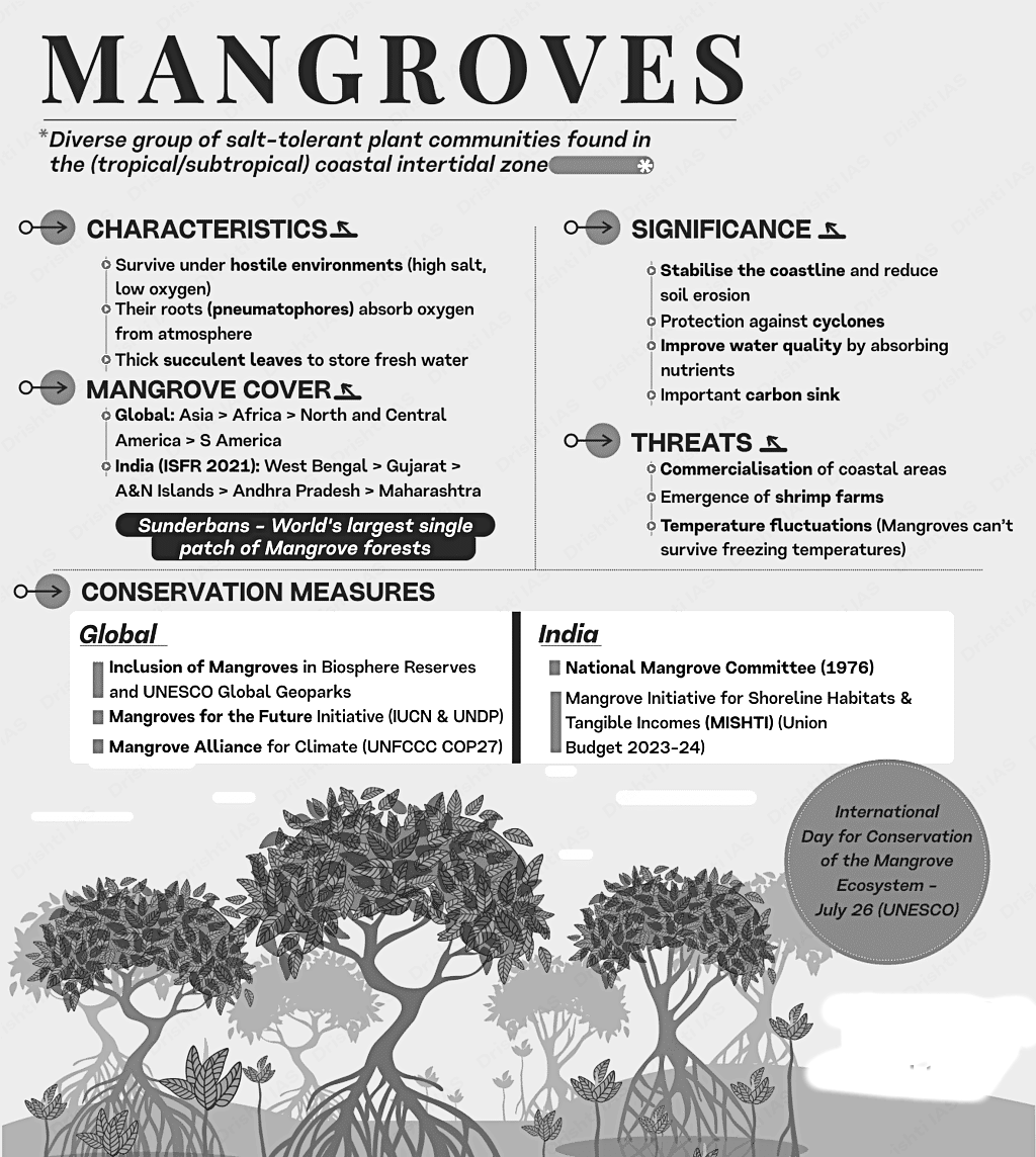 What is the State of Mangroves?
The World of Mangroves:
- Data regarding the location and extent of mangroves is essential for their conservation and protection. Initial global maps of mangrove forests were created in 1997, with updates in 2010 and 2011, but these maps were not regularly revised.
- Since 2018, the Global Mangrove Watch (GMW) has been providing a time series of global mangrove extent maps from 1996 to 2020, with the fourth version (GMW v4.0) released in 2024.
- The GMW v4.0 estimates a global mangrove extent of 147,256 km, comparable to the previous version but with more detailed changes at higher resolutions.
- The accuracy of the GMW v4.0 map is approximately 95.3%, an improvement over its predecessor due to better satellite imagery, improved training data, and advanced machine learning techniques.
- Future efforts will focus on re-mapping historical data to better assess changes over time.
- The GMW v4.0 has identified mangroves across 128 countries, an increase of six from the last version. Southeast Asia contains nearly 50,000 km of mangrove cover, accounting for about one-third of the global total, with Indonesia alone housing 21% of the world's mangroves.
- The northernmost mangroves are found on St. George's Island in Bermuda (latitude 32.36°), while the southernmost extend to latitude 38.90° in Victoria, Australia.

The Diversity of Mangroves:
- Mangrove plants, which flourish in tropical and subtropical coastal areas, exhibit a variety of specialized adaptations. However, the current global list of species specific to mangroves is subjective and incomplete, highlighting the need for an updated authoritative list.
- There is ongoing debate regarding the criteria for classifying a plant as mangrove-specific, leading to confusion with species that may merely coexist with mangroves, such as tidal marsh species.
- Newly described species and subspecies underscore the gaps in our understanding of mangrove biodiversity.
- Taxonomic challenges regarding hybrid species complicate their classification and inclusion in conservation assessments like the IUCN Red List.
- Many mangrove species possess unique characteristics, such as above-ground breathing roots, specialized trunk structures, salt-excreting leaves, and viviparous propagules that develop while still attached to the parent plant.
- The IUCN Mangrove Specialist Group is working to establish a definitive list of mangrove species utilizing expertise in biogeography and taxonomy, with updates available on their platform.
Adjacent Ecosystems:
- Mapping the interconnected coastal ecosystems, which include mangroves, tidal marshes, seagrass meadows, tidal flats, and coral reefs, is complex but is improving thanks to advanced remote sensing and computational technologies.
- A global tidal marsh map created in 2023 indicates an extent of 52,880 km², primarily in temperate and Arctic regions, while also identifying over 7,000 km² in tropical areas, often situated behind mangroves.
- Efforts like the Caribbean Carbon Accounting in Seagrass (CariCAS) network enhance our understanding of seagrass extent and carbon stocks, emphasizing their critical role in climate change mitigation despite existing uncertainties in mapping.
- Coral reefs, mapped globally by the Allen Coral Atlas, along with tidal flats, are vital for carbon storage and storm protection but are threatened by human activities, necessitating holistic conservation strategies that consider the interdependence of mangroves and their adjacent ecosystems.

What are the Drivers of Change to the World’s Mangroves During 2000-2020?
Food and Agriculture Organization of the United Nations (FAO) Study:
- The FAO conducted a comprehensive study on the global status of mangroves, utilizing innovative methodologies that combined remote sensing with local knowledge to assess changes in mangrove areas.
- Between 2000 and 2020, the conversion of mangroves for aquaculture, oil palm plantations, and rice production accounted for 43.3% of global mangrove loss.
- Natural factors, termed "natural retraction," caused by shifts in riverbeds, sediment inputs, or sea level changes, contributed to 26% of mangrove loss over the last two decades.
- Overall, natural expansion has been significant, comprising 82% of global gains, with restoration efforts contributing 25% and 33% to mangrove expansion in South and Southeast Asia and Africa, respectively.
- Surprisingly, the natural expansion of mangroves has outpaced natural retraction, demonstrating their resilience and the complex dynamics between local environmental conditions and the impacts of global warming.

The Red List of Mangrove Ecosystems:
- The International Union for Conservation of Nature (IUCN) has led a global study involving over 250 scientists from 44 countries to create the Global Red List of Mangrove Ecosystems.
- This study classified the world’s mangrove ecosystems into 36 provinces and piloted the Red List of Ecosystems (RLE) methodology in Southeast Asia.
- It was found that 18 mangrove provinces, which represent about 50% of global mangrove area, are threatened, with eight provinces classified as Endangered or Critically Endangered.
- Climate change, especially severe cyclonic storms and sea-level rise, poses a threat to one-third of the assessed mangrove provinces, impacting 37% of the global mangrove area.
- Historical losses have placed 28% of mangrove provinces (38% of the global area) at risk, with mangrove conversion slowing in South and Southeast Asia, but accelerating in the Gulf of Guinea region.
- The RLE study can guide national assessments and actions to mitigate mangrove loss, urging countries to prioritize reliable local assessments for effective decision-making.

Nutrient Pollution:
- Anthropogenic pollutants, particularly nitrogen, pose an increasing threat to mangrove ecosystems.
- Estuarine mangroves receiving high freshwater inflow are susceptible to nutrient pollution, which can lead to eutrophication. Agricultural and aquaculture activities release nitrogen-rich runoff into these areas.
- In the Indian Sundarbans, elevated nitrogen levels negatively impact microbial productivity, with pollutants from the Ganges-Brahmaputra-Meghna Delta exacerbating the situation.
Pollution and Microbe:
- Freshwater inflow into mangrove ecosystems carries various pollutants, including antibiotics and heavy metals, which stress microbial populations and potentially lead to antimicrobial resistance and emerging diseases.
What is the Role of Local Communities in Conserving Mangroves?
Engaging with Local Ecological Knowledge (LEK) in Research and Practice:
- Local ecological knowledge (LEK) can provide crucial information for developing effective mangrove conservation and restoration strategies that ensure long-term outcomes.
- The Global Mangrove Alliance's LEK Best-Practice Guide offers comprehensive guidance on how to ethically and effectively integrate LEK into mangrove research and conservation projects.
- It emphasizes the importance of raising awareness about the diversity and significance of LEK related to mangrove ecosystems.
- The guide also encourages greater engagement of LEK in conservation efforts and highlights the need for equitable collaboration with local communities.

Invasive Oysters:
- The invasive oyster species Saccostrea cucullata, originating from the Indo-Pacific, was first reported in Brazil in 2014. This invasive species is expanding its range and competing with the native mangrove oyster Crassostrea brasiliana, leading to adverse social and ecological impacts.

Diversified Livelihoods For Mangrove Communities:
- Effective mangrove management must ensure that local communities can engage sustainably and benefit from mangroves.
- In areas where population growth coincides with diminishing mangrove resources, there is a need for sustainable practices and new opportunities for livelihoods, both within and beyond mangrove areas.
- Mangroves are often referred to as "fish factories," as they produce large quantities of commercially valuable species.
- Salt production is commonly conducted near mangrove forests, but it can negatively impact these ecosystems through habitat clearance. Sustainable practices, such as restricting salt production to non-mangrove areas, can mitigate these effects.
- For instance, in Guinea, 30% of salt is now produced through natural evaporation of brine, which is a more sustainable practice.
- Sustainable timber harvesting involves careful management practices to retain the valuable ecosystem services provided by mangrove forests.
- In regions like Mexico and South America, traditional beekeeping practices are being revived, allowing communities to generate income while assisting the survival of native bee species.
- In Ecuador, community members from the Sabana Grande Association have established a mangrove nursery to grow seedlings for restoring abandoned shrimp ponds, creating income through local restoration efforts.
- Tourism and recreation activities, such as recreational fishing in mangrove-adjacent areas, are increasingly popular among both locals and tourists.
Connecting Across Scales:
- Global models and datasets are essential for understanding mangrove ecosystems, including their coverage, fishery yields, and carbon stocks.
- Such models are crucial for informing international policies, strategies, and targets, including those set under the Sustainable Development Goals, the Paris Agreement, and the Convention on Biological Diversity.
- Enhancing global analyses with local data improves model accuracy and supports standardization while aiding national efforts in mangrove conservation and restoration.
- The potential of citizen science initiatives has proven invaluable for biodiversity monitoring.
Coastal Carbon Network (CCN):
- The Coastal Carbon Network (CCN) is a consortium focused on scientific research and coastal ecosystem management, guided by the Smithsonian Institution. It aims to advance knowledge, inform policy, and enhance coastal ecosystem management.
Blue Carbon Explorer:
- The Nature Conservancy (TNC) launched the Blue Carbon Explorer in April 2023, which utilizes satellite imagery and field data to create refined maps of mangroves and seagrass in the Caribbean.
What are the Benefits of Mangroves?
Mangrove Blue Carbon:
- The updated global model for 2023 indicates that mangrove soils and biomass play a significant role in carbon storage, primarily concentrated in the top meter of soil, thereby aiding in carbon sequestration and emissions mitigation.
- Mangroves typically store an average of 394 tonnes of carbon per hectare, with 319 tonnes in the soil, 54 tonnes in above-ground biomass, and 21 tonnes in below-ground biomass.
- Southeast Asia, particularly regions like Sumatra and Borneo in Indonesia, has the highest stocks of blue carbon, with substantial amounts also found in West Africa, Central and South America, and the Caribbean.
Biodiversity in Global Mangrove Ecosystems:
- Mangrove ecosystems are biologically diverse, providing a variety of conditions and niches for numerous organisms, including terrestrial and aquatic species.
- These ecosystems serve as nurseries and feeding grounds for various marine species, including crabs, prawns, mollusks, and fish, while also hosting a wide range of microorganisms.
- Insect diversity in mangroves can be particularly high, with over 3,000 insect species documented in Singapore’s mangrove areas alone.
- The Sundarbans mangrove region in India and Bangladesh is home to several globally threatened species, including tigers and dolphins.
- India's mangrove ecosystems boast a remarkable biodiversity record, with 5,746 species identified, of which 4,822 are animals, representing a significant portion of Indian fauna.
- Despite their ecological importance, the species richness of mangrove regions worldwide remains poorly documented due to a lack of extensive field surveys.
- Globally, many mangrove species are endemic, with a significant number facing threats of extinction.
Mangroves in the Galápagos Islands:
- The Galápagos Islands, known for their unique conservation status and biodiversity, also host mangrove forests along their volcanic coastlines, providing essential environmental services to local wildlife such as penguins.
Mangroves’ Interaction With Incoming Coastal Stormwaters:
- Flooding is a common natural disaster, with 1.3% of the global population living in areas prone to severe coastal flooding.
- Mangroves influence coastal flooding patterns by slowing down storm surges and reducing wind and wave strength.
- While they cannot completely prevent high water levels during storms, mangroves can significantly lower flood depths by 15-20%, with reductions exceeding 70% in some cases during severe storms.
- Studies indicate that even small mangrove patches can effectively reduce flood impacts, depending on factors such as forest characteristics and storm conditions.
How Mangroves are Related to Food Security?
Food Security and Mangroves:
- Mangroves are among the world's most productive ecosystems, supporting a rich food web and providing food, fiber, and fuels that contribute to human well-being.
- They play a vital role in all four dimensions of food security: availability, access, utilization, and stability.

Mangrove Fisheries:
- Fish and seafood harvested from mangrove ecosystems are rich in vital nutrients, including proteins, omega-3 fatty acids, vitamins, and minerals.
- A global collaboration of nearly 50 mangrove fisheries scientists has developed models to estimate the density and abundance of commercially important species utilizing mangroves.
- Field data on 37 species indicates that mangroves support nearly 800 billion young fish, prawns, bivalves, and adult crabs each year.
Non-Aquatic Foods:
- Mangrove ecosystems also provide non-aquatic food resources; for example, some mangrove leaves and local herbs are collected for consumption as vegetables.
- Mangrove leaves are also utilized as fodder for livestock, such as goats and sheep, especially in arid regions.
- Fuelwood and charcoal sourced from mangroves are essential for coastal communities, used for cooking and other daily needs.
Source of Income:
- The economic stability of coastal communities often relies on the sale of products derived from mangroves, including fish, timber, honey, and non-wood forest products.
- Mangroves provide critical ecosystem services that support food production and resilience over time.
Fish Nurseries in the Tallest Mangroves of the Americas:
- The Esfuerzo Pescador community council in Colombia hosts one of the tallest mangrove forests globally, rich in fish diversity. A participatory fishing monitoring program has been implemented to identify and mitigate unsustainable practices.
Alarming Environmental Decline in the Aravallis
A recent scientific study has exposed the severe environmental repercussions of ongoing land use changes in the Aravallis. The study reveals that the continuous destruction of these hills is causing significant biodiversity loss, soil degradation, and a decline in vegetation cover, signaling an urgent need for comprehensive conservation strategies to reverse these damaging trends.

Challenges Facing the Aravallis
- Loss of Land: Between 1975 and 2019, about 8% (5,772.7 sq km) of the Aravalli region was lost, including 5% turned into barren land and 1% into settlements.
- Environmental Impact: This degradation facilitated the expansion of the Thar Desert towards the National Capital Region, increasing desertification and erratic weather patterns.
- Mining Expansion: The area used for mining increased from 1.8% in 1975 to 2.2% in 2019, contributing significantly to the degradation of the Aravalli hills.
- Urbanization and Mining: Rapid urbanization alongside unchecked mining practices are major factors in the degradation, with over 25% of the Aravallis lost to illegal quarrying.
- Air Pollution: Mining activities significantly contribute to air pollution in the NCR, particularly through respirable particulate matter (RPM).
- Decline in Forest Cover: The central range’s forest cover has reduced by 32% from 1975 to 2019, paralleled by an increase in cultivated land.
- Water Resource Impact: Mining activities have disrupted aquifers, altering water flows, drying up lakes, and creating new water bodies.
- Protected Areas’ Impact: Wildlife sanctuaries like Todgarh-Raoli and Kumbhalgarh have positively impacted the eco-sensitive zones, showing minimal forest depletion.
- Enhanced Vegetation Index (EVI): EVI least value of 0 to -0.2 in upper central Aravali region (Nagaur district) – indicating unhealthy vegetation.
Enhanced Vegetation Index (EVI) Explained
- EVI Overview: EVI is an advanced vegetation index designed for higher sensitivity to biomass, atmospheric conditions, and soil quality, serving as a modified version of the Normalized Difference Vegetation Index (NDVI).
- EVI Significance: The index ranges from 0 to 1, where values closer to 1 indicate healthier vegetation, while values closer to 0 suggest unhealthy vegetation, providing a crucial tool for environmental monitoring.
Future Projections and Biodiversity
- Projected Loss: By 2059, it is projected that 22% of the Aravalli area could be lost, with 3.5% potentially used for mining purposes.
- Biodiversity Decline: There has been a significant decrease in local wildlife, including leopards, striped hyenas, and golden jackals.
- River Impacts: Key rivers originating from the Aravallis, such as Banas, Luni, Sahibi, and Sakhi, are now dead, reflecting the severe environmental stress in the region.
- Human-Wildlife Conflicts: The loss of natural forests has escalated conflicts between humans and wildlife in the area, highlighting the urgent need for conservation and sustainable management strategies.
Aravalli Range
- The Aravalli Range extends 692 km from Gujarat to Delhi, passing through Rajasthan, with a width ranging from 10 to 120 km.
- Approximately 80% of the range is situated within Rajasthan, with the remaining 20% spread across Haryana, Delhi, and Gujarat.
- The range is segmented into two primary sections: the Sambhar Sirohi Range and the Sambhar Khetri Range in Rajasthan, spanning about 560 km.
- The Aravallis serve as an ecotone, acting as a transition zone between the Thar Desert and the Gangetic Plain, where diverse ecosystems and biological communities converge.
- Gurusikhar, located in Rajasthan, is the highest peak of the Aravallis, standing at an elevation of 1,722 meters.
Significance of the Aravallis
- The Aravallis play a crucial role in halting the advancement of the Thar Desert towards the fertile Indo-Gangetic plains, also serving as vital catchment areas.
- Home to 300 native plant species and 120 bird species, the range is a sanctuary for various animals, including jackals and mongooses.
- During the monsoon season, the Aravallis guide monsoon clouds eastward, benefiting the sub-Himalayan rivers and North Indian plains, while in winter, they protect the fertile valleys from harsh westerly winds.
- The range significantly contributes to groundwater replenishment by capturing rainwater, thereby enhancing the groundwater levels.
- Often referred to as the “lungs” of Delhi-NCR, the Aravallis mitigate some of the severe air pollution effects experienced in the region.
Owlflies

Why in news?
Recently, a rare species of owlfly, Glyptobasis dentifera, has been rediscovered after 75 years in Kerala by researchers.
Owlflies
- Owlflies belong to the order Neuroptera, which comprises holometabolous insects. This sets them apart from dragonflies, which are categorized under the order Odonata and are hemimetabolous.
- Due to their similar appearance, owlflies are often mistakenly identified as dragonflies by those unfamiliar with entomological taxonomy.
During daylight hours, adult owlflies are typically found perched on grass blades in lateritic soils or around homes within densely vegetated areas.
- Distinctive Features: Owlflies are recognized by their long, clubbed antennae, nearly as long as their bodies, and prominent bulging eyes. Post-emergence, some owlflies exhibit color changes in their wings.
- Diet and Defense: As aerial predators, owlflies primarily feed on other insects. They are known to emit a strong, musk-like chemical when threatened, which serves to repel potential predators.
- Reproductive Strategy: Owlflies typically deposit their eggs in clusters at the extremities of branches or twigs. To safeguard the eggs from predators, the female constructs a protective barrier beneath the egg clusters.
- Larval Development: Owlfly larvae are generally found either in soil or residing in tree clusters, leveraging these environments for protection.
Clean Plant Programme

Why in news?
The Union Cabinet has recently approved the Clean Plant Programme (CPP), which aims to enhance the yield and productivity of horticultural crops in India. This initiative focuses on providing disease-free and high-quality planting material for various horticultural products, including fruits, vegetables, and flowers.
- Introduced in the interim Budget speech by Union Finance Minister Nirmala Sitharaman in February 2023.
- Primary objective of the CPP is to improve productivity and quality of horticultural produce.
- Access to certified, disease-free planting materials for farmers is a key focus.
- Expected outcomes include a reduction in crop losses and improved overall yields.
- Requested budget allocation by the Ministry of Agriculture is Rs 1,765 crore for this program.
- Funding sources: Half from the Mission for Integrated Development of Horticulture (MIDH) and half from a loan from the Asian Development Bank (ADB).
Components of the Clean Plant Programme:
- Establishment of Nine Clean Plant Centers (CPCs) for disease diagnostics and treatment.
- Development of mother plants for nurseries to ensure quality planting materials.
- Quarantine procedures for all planting materials intended for commercial propagation.
- Infrastructure development includes large-scale nurseries to efficiently multiply clean planting materials.
- Strong regulatory and certification process will ensure accountability and traceability.
India's Horticulture Sector:
- Second-largest producer of fruits and vegetables worldwide, after China.
- Significant growth in horticulture sector over the past decade.
- Area dedicated to horticultural crops increased from 24 million hectares in 2013-14 to 28.63 million hectares in 2023-24.
- Production rise from 277.4 million metric tonnes to 352 million metric tonnes during this period.
India's Role in the Global Fruit Market:
- Major player in the global fruit market as both importer and exporter.
- Exports of fresh fruits worth $1.15 billion in the fiscal year 2023-24.
- Imports of fruits valued at $2.73 billion in the same period.
- Increasing demand for foreign planting materials, especially for apples and exotic fruits.
- Surge in imports of planting materials from 2018 to 2020.
- Apple plant imports increased from 21.44 lakh to 49.57 lakh.
- Avocado plant imports rose from 1,000 to 26,500.
- Blueberry plant imports grew from 1.55 lakh to 4.35 lakh.
- Lengthy process for importing plants currently involves a two-year quarantine period.
- Clean Plant Centers aim to reduce this quarantine time to six months.
- Facilitating easier access for farmers to disease-free and authentic planting materials.
- Modeled after successful initiatives in the United States, Israel, and the Netherlands.
Understanding Horticulture:
- Horticulture focuses on the cultivation of plants for food, medicinal purposes, and aesthetic enjoyment.
Difference Between Horticulture and Olericulture:
- Horticulture involves the maintenance and development of gardens.
- Olericulture specifically deals with the production, processing, and storage of vegetables and fruits.
Ideas4LiFE Portal
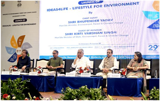 Recently, the Union Minister for Environment, Forest and Climate Change Bhupender Yadav launched Ideas4LiFE at IIT Delhi.
About
- It was launched for inviting ideas related to products and services, which induce behavioral changes related to environment-friendly lifestyles.
- This initiative aims to encourage and motivate students, faculty and research scholars to contribute their innovative ideas to the global initiative of Mission LiFE.
- It is a remarkable opportunity for inspired minds to participate in global movement dedicated to environmental sustainability.
Key facts about Mission LiFE
- Mission LiFE, or Lifestyle for Environment, is an India-led global mass movement to nudge individual and community action to protect and preserve the environment.
- It was launched at the 26th UN Climate Change Conference of the Parties (COP26) in Glasgow in November 2021.
- The program hopes to “mobilize one billion Indians as well as people in other countries to become individuals who practice sustainable lifestyles.
- It emboldens the spirit of the P3 model, i.e., Pro Planet People.
- It aims at following a three-pronged strategy for changing people's collective approach towards sustainability,
- nudging individuals to practice simple yet effective environment-friendly actions in their daily lives (demand)
- enabling industries and markets to respond swiftly to the changing demand (supply)
- to influence government and industrial policy to support both sustainable consumption and production (policy).
Great Barrier Reef

Why in news?
Water temperatures in and around Australia’s Great Barrier Reef have risen to their warmest in 400 years over the past decade, according to a new study.
Overview
- The Great Barrier Reef is a vast network of coral reefs, shoals, and islets located in the Pacific Ocean.
- It is situated off the northeastern coast of Australia in the Coral Sea.
- Recognized as the longest and largest reef system worldwide, it is also the largest living structure on Earth.
- The reef extends over 2,300 km in a northwest-southeast direction, with an offshore distance of 16 to 160 km, and a width ranging from 60 to 250 km.
- Covering an area of approximately 350,000 square km, it is large enough to be seen from space.
- The structure consists of nearly 3,000 individual reefs and over 900 islands.
- In 1981, UNESCO designated the Great Barrier Reef as a World Heritage Site.
- A significant portion of the reef is designated as a marine protected area, overseen by the Great Barrier Reef Marine Park Authority of Australia.
Biodiversity
- The reef is estimated to house around 2,000 species of fish and approximately 600 different species of coral.
- It is also home to 4,000 species of mollusks and over 250 different shrimp species.
- Notably, the reef supports six of the seven known species of sea turtles, along with numerous sea snakes and nearly two dozen bird species.
|
95 videos|234 docs|52 tests
|


Environment and Ecology: August 2024 UPSC Current Affairs | Environment for UPSC CSE
,Environment and Ecology: August 2024 UPSC Current Affairs | Environment for UPSC CSE
,video lectures
,Objective type Questions
,Important questions
,study material
,shortcuts and tricks
,practice quizzes
,ppt
,mock tests for examination
,Exam
,MCQs
,past year papers
,Viva Questions
,Semester Notes
,Extra Questions
,Previous Year Questions with Solutions
,Summary
,Sample Paper
,Environment and Ecology: August 2024 UPSC Current Affairs | Environment for UPSC CSE
,Free
;


Environment and Ecology: August 2024 UPSC Current Affairs Free PDF Download
Importance of Environment and Ecology: August 2024 UPSC Current Affairs
Environment and Ecology: August 2024 UPSC Current Affairs Notes
Environment and Ecology: August 2024 UPSC Current Affairs UPSC Questions
Study Environment and Ecology: August 2024 UPSC Current Affairs on the App
|
© EduRev
|
Education Revolution
|


|


