Geography: CBSE Sample Question Paper with Solutions - 3 | Sample Papers for Class 11 Humanities - Humanities/Arts PDF Download
Geography
Time: 2 Hrs.
M.M: 80
General Instructions:
(i) All questions are compulsory.
(ii) Question number 1 to 14 are Multiple choice questions carrying 1 mark each.
(iii) Question number 15 to 16 are Multiple source based questions carrying 3 marks each.
(iv) Question number 17 to 21 are Short-answer questions carrying 3 marks each. Answer to each of these questions should not exceed 80 – 100 words.
(v) Question number 22 to 26 are Long-answer questions carrying 5 marks each. Answer to each of these questions should not exceed 150 words.
(vi) Question number 27 and 28 are related to identification and locating and labelling of geographical features on maps, carrying 5 marks each.
(vii) Outline maps of the World and India provided to you must be attached within your answer-book
(viii) Use of templates and stencils for drawing outline maps is allowed.
Q.1. There are ___ inner planets.
(a) five
(b) seven
(c) four
(d) six
Correct Answer is Option c.
Q.2. The mega-ocean meaning all water was called:
(a) Lurasia
(b) Panthalassa
(c) Tillite
(d) Pangaea
Correct Answer is Option b.
Q.3. Which one of the following is the hardest mineral:
(a) Topaz
(b) Feldspar
(c) Diamond
(d) Quartz
Correct Answer is Option c.
Q.4. Which one of the following sentences best defines the term ‘Lapies’:
(a) A landform whose opening is more or less circular at the top and funnel-shaped towards bottom
(b) A small to medium sized shallow depression
(c) An irregular surface with sharp pinnacles, grooves and ridges
(d) A landform forms due to dripping water from surface
Correct Answer is Option b.
Q.5. Make correct pairs from the following two columns:
(i) (c); (ii) (d); (iii) (b); (iv) (a).
Q.6. Arrange the hydrologic cycle in correct order: E
(i) Collection
(ii) Evaporation
(iii) Precipitation
(iv) Convection
Options:
(a) i, iv, iii, ii
(b) iv, ii, iii, i
(c) ii, iv, iii, i
(d) iii, iv, ii, i
Correct Answer is Option c.
Q.7. Temperature is high throughout the year and diurnal ranges of temperature are the greatest in the dry season. This is a characteristic of:
(a) Tropical wet climate
(b) Tropical monsoon climate
(c) Tropical wet and dry climate
(d) Tropical dry climate
Correct Answer is Option c.
Q.8. Geography helps in understanding the reality in its_________ perspective.
(a) spatial
(b) holistic
(c) physical
(d) overall
Correct Answer is Option a.
Q.9. The earthquakes are measured on:
(a) Gravity Scale
(b) Victor Scale
(c) Shadow Scale
(d) Richter Scale
Correct Answer is Option d.
Q.10. Which one of the following is the type of plate boundary of the Indian plate along the Himalayan mountains:
(a) Continent-continent convergence
(b) Transform boundary
(c) Divergent boundary
(d) Ocean-continent convergence
Correct Answer is Option a.
Q.11. The grooved , fluted features in an open limestone field is known as:
(a) doline
(b) uvalas
(c) valley sink
(d) ridges
Correct Answer is Option d.
Q.12. Sea salt, pollen, ash, smoke-soot, fine soil — these are associated with:
(a) Dust particles
(b) Meteors
(c) Water vapour
(d) Gases
Correct Answer is Option a.
Q.13. Arrange the Peninsular rivers from the longest to the shortest in the correct order: E
(i) Godavari
(ii) Krishna
(iii) Kaveri
(iv) Narmada
Options:
(a) ii, iii, iv, i
(b) iv, iii, ii, i
(c) iv, ii, iii, i
(d) i, ii, iii, iv
Correct Answer is Option d.
Q.14. The Inter Tropical Convergence Zone normally occurs:
(a) Near the Tropic of Cancer
(b) Near the Equator
(c) Near the Arctic Circle
(d) Near the Tropic of Capricorn
Correct Answer is Option b.
Q.15. Read the case study given below and answer any three of the questions that follow.
If soil erosion and exhaustion are caused by humans; by corollary, they can also be prevented by humans. Nature has its own laws of maintaining balance. Nature offers enough opportunities for humans to develop their economy without disturbing the ecological balance. Soil conservation is a methodology to maintain soil fertility, prevent soil erosion and exhaustion, and improve the degraded condition of the soil. Soil erosion is essentially aggravated by faulty practices. The first step in any rational solution is to check open cultivable lands on slopes from farming. Lands with a slope gradient of 15-25 per cent should not be used or cultivation. If at all the land is to be used for agriculture, terraces should carefully be made. Over-grazing and shifting cultivation in many parts of India have affected the natural cover of land and given rise to extensive erosion. It should be regulated and controlled by educating villagers about the consequences. Contour bunding, Contour terracing, regulated forestry, controlled grazing, over cropping, mixed farming and crop rotation are some of the remedial measures which are often adopted to reduce soil erosion. Efforts should be made to prevent gully erosion and control their formation. Finger gullies can be eliminated by terracing. In bigger gullies, the erosive velocity of water may be reduced by constructing a series of check dams. Special attention should be made to control headward extension of gullies. This can be done by gully plugging, terracing or by planting cover vegetation. In arid and semi-arid areas, efforts should be made to protect cultivable lands from encroachment by sand dunes through developing shelter belts of trees and agro -forestry. Lands not suitable for cultivation should be converted into pastures for grazing. Experiments have been made to stabilise sand dunes in western Rajasthan by the Central Arid Zone Research Institute (CAZRI).
(i) Finger gullies can be eliminated by__________:
(a) mixed farming
(b) plantation farming
(c) shift cultivation
(d) terracing
Correct Answer is Option d.
(ii) Nature has its own laws of maintaining ________.
(a) coexistence
(b) balance
(c) happiness
(d) destruction
Correct Answer is Option a.
(iii) What should be done to land which is not suitable for cultivation?
(a) Should be used for slash farming
(b) Should not be used at all
(c) Should be used for grazing
(d) Should be left for a year and again cultivated
Correct Answer is Option c.
Q.16. Read the case study given below and answer any three of the questions that follow.
We all know that the earth rotates from west to east over its axis. It makes the sun rise in the east and set in the west. The rotation of the earth over its axis takes 24 hours to complete one circle or 360° of longitudes. As 180° of longitudes fall both east and west of the Prime Meridian, the sun, thus takes 12 hours’ time to traverse the eastern and western hemispheres. In other words, the sun traverses 150 of longitudes per hour or one degree of longitude in every four minutes of time. It may further be noted that the time decreases when we move from west to east and increases with our westward movement. The rate of the time at which the sun traverses over certain degrees of longitudes is used to determine the local time of an area with respect to the time at the Prime Meridian (0° Longitude).
(i) How much time does the Sun takes to traverse the eastern and western hemispheres?
(a) 14 hours
(b) 12 hours
(c) 16 hours
(d) 10 hours
Correct Answer is Option b.
(ii) The Prime Meridian is drawn from ____________.
(a) east to west
(b) west to east
(c) north to south
(d) south to north
Correct Answer is Option c.
(iii)___________ of longitudes fall both east and west of the Prime Meridian.
(a) 180°
(b) 120°
(c) 160°
(d) 140°
Correct Answer is Option a.
Q.17. "The angle of inclination of the rays determines the amount of insolation received." How?
The amount of insolation, or incoming solar radiation, that is received at any given point on the Earth's surface depends on the angle at which the sun's rays strike the Earth's surface. The angle of inclination of the rays is determined by the latitude of the location and the time of year. At the equator, the sun's rays strike the Earth's surface at a near-90 degree angle throughout the year, providing a consistently high amount of insolation. However, as you move away from the equator towards the poles, the angle at which the sun's rays strike the Earth's surface becomes more oblique, and the amount of insolation received decreases.
This is because the same amount of solar energy is spread over a larger area as the angle becomes more oblique. For example, when the sun's rays hit the Earth's surface at a 30 degree angle, the same amount of energy is spread over twice as much surface area as when the rays hit the Earth's surface at a 60 degree angle. This means that the energy received per unit area decreases as the angle becomes more oblique. Additionally, the angle of inclination of the sun's rays changes throughout the year as the Earth's tilt changes. During the summer months, the northern hemisphere is tilted towards the sun, resulting in more direct sunlight and higher insolation. Conversely, during the winter months, the northern hemisphere is tilted away from the sun, resulting in more oblique sunlight and lower insolation.
Overall, the angle of inclination of the sun's rays plays a critical role in determining the amount of insolation received at any given point on the Earth's surface, and this has important implications for weather patterns, climate, and ecosystems.
Q.18. Describe the climatic conditions Koeppen mentions.
Koeppen developed a classification system for climates based on monthly temperature and precipitation data. The system identifies five major climate types: tropical climates, characterized by mean monthly temperatures over 18°C throughout the year; dry climates, which have very low precipitation relative to temperature and can be either semi-arid (S) or arid (W); warm temperate climates, where the mean temperature of the coldest month is between 18°C and minus 3°C; cool temperate climates, where the mean temperature of the warmest month is over 10°C and the mean temperature of the coldest month is under minus 3°C; and ice climates, where the mean temperature of the warmest month is less than 10°C.
Q.19. Explain what earthquakes are and elaborate on the concepts of focus/hypocenter and epicenter? Describe the methods used for measuring earthquake magnitude and intensity.
Earthquakes are the sudden shaking or trembling of the Earth's surface caused by the sudden release of energy from the Earth's crust. This energy release is caused by the movement of tectonic plates, which are the massive slabs of rock that make up the Earth's surface. The focus or hypocenter of an earthquake is the point within the Earth where the energy is released. It is the exact point where the earthquake originates, and it can be located anywhere from a few kilometers to hundreds of kilometers below the surface of the Earth.
The epicenter is the point on the Earth's surface directly above the focus. This is the point where the earthquake is typically felt the strongest and where most of the damage occurs. The epicenter is usually the point that is reported in the news and is used to identify the location of the earthquake. There are two main scales used to measure the magnitude of an earthquake: the Richter scale and the moment magnitude scale. The Richter scale measures the amplitude of the seismic waves generated by the earthquake, while the moment magnitude scale takes into account the size of the area that ruptured and the amount of energy released.
The intensity of an earthquake is measured using the Modified Mercalli Intensity Scale, which rates the effects of an earthquake on people, buildings, and the natural environment. This scale ranges from I (not felt) to XII (total destruction). Seismographs are used to detect and measure earthquakes. They record the seismic waves generated by the earthquake and can be used to determine the earthquake's magnitude and epicenter. Additionally, advanced technology and satellite data are used to monitor and predict earthquakes, helping to reduce the damage caused by these natural disasters.
Q.20. What are landslides' disastrous effects?
While landslides have a limited and confined direct impact, their consequences can be far-reaching. For instance, they can cause blockages in roads and railways, as well as in channels due to rock falls. This can disrupt transportation and impede spatial interaction, making it risky, difficult, and expensive to undertake developmental activities in these areas. Additionally, landslides can result in the diversion of river courses, potentially leading to flooding and causing loss of life and property.
Q.21. What are your knowledge of the world's deepest ocean trenches?
According to information, there have been 57 deep trenches discovered around the world, with the majority being located in the Pacific Ocean (32), followed by the Atlantic Ocean (19), and the Indian Ocean (6). The Mariana Trench is currently recognized as the world's deepest trench, situated in the Pacific Ocean and reaching a depth of 11,034 meters. Other significant trenches include the Puritonko Trench, which is the deepest trench in the Atlantic Ocean, and the Sunda Trench, which is the deepest trench found in the Indian Ocean.
Q.22. Define drought. Describe the many types of droughts that occur in India.
Drought is a natural disaster that occurs when there is an extended period of abnormally dry weather in a region, resulting in a shortage of water for human, animal, and plant populations. It is a gradual process that usually takes place over an extended period of time, and its impact can be felt for several years.
In India, there are four different types of droughts that occur, each with its own specific characteristics:
- Meteorological drought: This type of drought occurs when there is a prolonged period of abnormally low rainfall or no rainfall in a region. This can lead to a shortage of water for agricultural purposes, as well as a shortage of drinking water for human and animal populations.
- Agricultural drought: This type of drought occurs when there is a significant decrease in soil moisture levels, leading to a decrease in crop yield. This can be caused by a lack of rainfall, high temperatures, or other factors that contribute to soil dryness.
- Hydrological drought: This type of drought occurs when there is a shortage of water in rivers, lakes, and other surface water sources. This can be caused by a lack of rainfall, as well as increased demand for water for irrigation and other purposes.
- Socio-economic drought: This type of drought occurs when there is a shortage of water that leads to economic or social problems, such as loss of income for farmers, food shortages, and increased poverty.
In India, drought is a recurring problem that affects millions of people every year. The impact of drought can be severe, with crop failures, food shortages, and water scarcity leading to economic and social problems. The government has implemented various measures to mitigate the impact of drought, such as providing subsidies to farmers for crop insurance and setting up drought monitoring and management systems. However, more needs to be done to address this critical issue and to ensure that India's population is adequately protected from the effects of drought.
Q.23. Describe the geographic variations in the country's rainfall.
India has a diverse climate and rainfall pattern due to its varied topography and location in the tropical zone. The spatial variation in rainfall across the country is influenced by various factors such as monsoons, ocean currents, topography, and the influence of nearby mountain ranges.
Monsoons: The Indian subcontinent experiences two distinct monsoons - the Southwest Monsoon and the Northeast Monsoon. The Southwest Monsoon, which occurs from June to September, brings the majority of the rainfall to most parts of the country, while the Northeast Monsoon, which occurs from October to December, brings rainfall to the southern parts of the country.
Topography: The topography of the country also plays a crucial role in determining the rainfall pattern. The Western Ghats, which run parallel to the western coast of India, receive heavy rainfall due to their location in the path of the Southwest Monsoon winds. Similarly, the Eastern Ghats receive less rainfall as they lie in the rain shadow region of the Southwest Monsoon winds.
Mountain ranges: The Himalayas and other mountain ranges in the northern part of the country also influence the rainfall pattern. These mountain ranges act as barriers, causing the moist monsoon winds to rise, cool, and condense, leading to heavy rainfall in the regions located on the windward side. In contrast, the leeward side of the mountains remains dry due to the rain shadow effect.
Ocean currents: The ocean currents, such as the Indian Ocean Dipole and the El Nino-Southern Oscillation, also influence the rainfall pattern in India. These currents affect the temperature and moisture content of the air, which can lead to either excess or deficient rainfall.
In summary, the spatial variation in rainfall across India is determined by a complex interplay of factors such as monsoons, topography, nearby mountain ranges, and ocean currents. The resulting rainfall pattern can vary significantly from one region to another, with some regions receiving heavy rainfall while others receiving very little.
Q.24. What is the differences between the food chain and food web.
A food chain is a linear sequence of organisms in which each organism feeds on the one that precedes it and is itself eaten by the organism that follows. For example, a simple food chain in a forest ecosystem could be: grass → rabbit → fox.
On the other hand, a food web is a more complex representation of the feeding relationships among species in an ecosystem. It consists of many interconnected food chains, which together form a network of interactions among species. In a food web, organisms can have multiple feeding relationships with other organisms, and the same organism can occupy different positions in different food chains.
In essence, a food chain is a simplified representation of the feeding relationships in an ecosystem, while a food web provides a more complete and detailed view of the complex interactions among species in an ecosystem.
Q.25. What distinguishes the Mountains of Arunachal, Himachal, Purvanchal, and Uttaranchal from one another?
Arunachal, Himachal, Purvanchal, and Uttarakhand (formerly Uttaranchal) are different regions of the Himalayas with distinct geographical, cultural, and historical characteristics.
Arunachal Himalayas: Located in the easternmost part of the Himalayan range, Arunachal Himalayas are characterized by rugged terrain, deep gorges, and steep valleys. This region is home to a diverse range of ethnic groups, including the Monpas, Apatanis, Adis, and Nyishis, among others. The region receives heavy rainfall, which supports a rich variety of flora and fauna.
Himachal Himalayas: The Himachal Himalayas extend over a distance of about 240 km from the Indus River in the west to the Satluj River in the east. This region is characterized by high mountain ranges, deep gorges, and valleys. The region is home to several hill stations, including Shimla, Manali, and Dharamshala, which are popular tourist destinations. Himachal Pradesh is also known for its rich cultural heritage, which includes several ancient temples, monasteries, and forts.
Purvanchal Himalayas: The Purvanchal Himalayas form the eastern part of the Himalayan range, stretching from the Brahmaputra River in the west to the Irrawaddy River in the east. The region is characterized by steep slopes, deep valleys, and dense forests. The region is home to several ethnic groups, including the Naga, Khasi, Garo, and Mizo, among others. The region is also known for its unique cultural traditions, which include several music and dance forms.
Uttarakhand Himalayas: Uttarakhand is located in the northern part of India and is known for its stunning natural beauty. The region is characterized by high mountain ranges, including the Garhwal and Kumaon ranges, which are home to several prominent peaks, including Nanda Devi and Trisul. Uttarakhand is also known for its rich cultural heritage, which includes several ancient temples, ashrams, and pilgrimage sites, including the Char Dham Yatra.
In summary, while all these regions are part of the Himalayan range, they differ in terms of their geographical features, ethnic diversity, and cultural heritage.
Q.26. Describe the characteristics of laterite soil.
Laterite soil is a type of soil that is found in tropical and subtropical regions with high rainfall and high temperatures. It is characterized by its reddish-brown color, its tendency to harden and become impenetrable when dry, and its high levels of iron and aluminum oxides.
Here are some of the key features of Laterite soil:
- Color: Laterite soil is typically reddish-brown in color, due to the high levels of iron and aluminum oxides in the soil.
- Texture: Laterite soil is generally coarse and porous, with a granular or gravelly texture. It has a low water-holding capacity and tends to harden and become impenetrable when dry.
- Nutrient content: Laterite soil is generally low in fertility, due to the high levels of leaching that occur in these regions. However, it does contain some nutrients, such as potassium, phosphorus, and calcium.
- Acidity: Laterite soil is generally acidic, with a pH range of 4.5-5.5. This acidity can be attributed to the high levels of leaching that occur in these regions, as well as the presence of organic acids in the soil.
- Geographical distribution: Laterite soil is found in tropical and subtropical regions around the world, including India, Brazil, and parts of Africa and Southeast Asia.
- Uses: Despite its low fertility, Laterite soil can be used for cultivation, especially in areas where there are no other options available. It is also used for road construction, as it is very hard and durable when compacted.
Laterite soil is a type of soil found in tropical and subtropical regions with high rainfall and high temperatures. It is characterized by its reddish-brown color, its tendency to harden when dry, and its high levels of iron and aluminum oxides. While it is generally low in fertility, it can be used for cultivation and road construction.
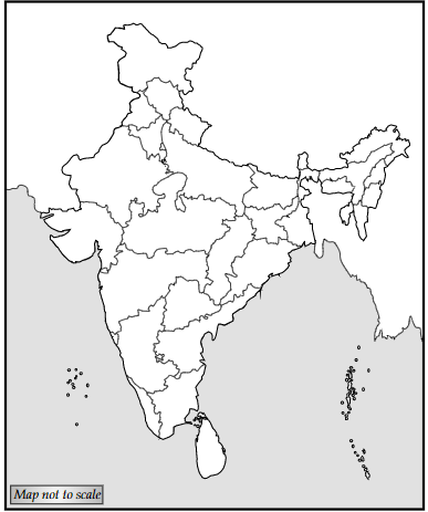
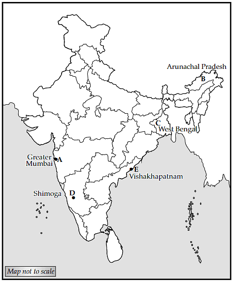
Q.27. Locate and label the following on the political outline map of India:
A. An important node on golden quadrilateral route in Maharashtra state
B. State with lowest level of population density
C. Largest rice producing state
D. Shimoga manganese mine
E. A major seaport in Andhra Pradesh

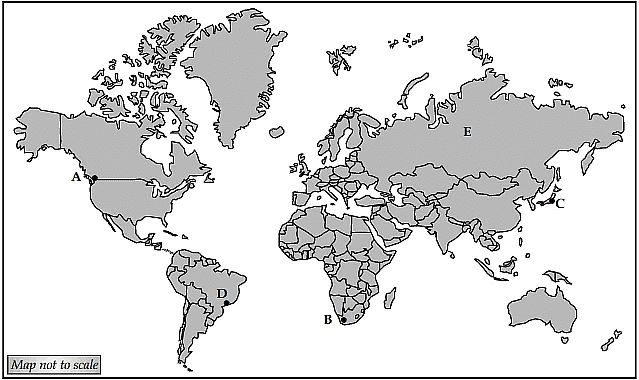
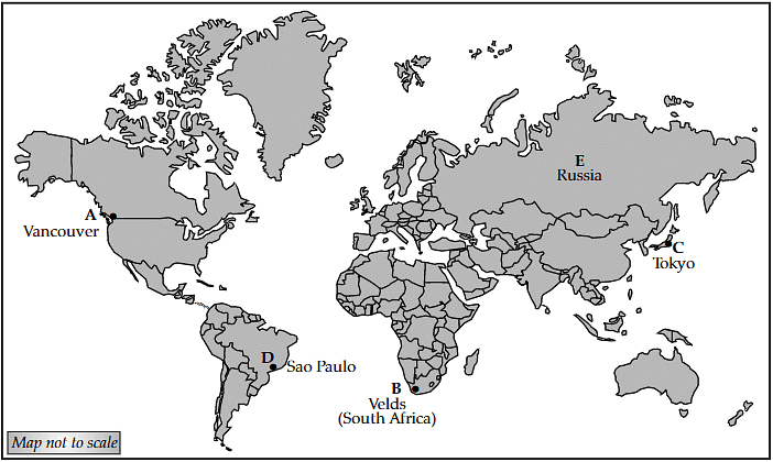
Q.28. Study the given world map and identify the features marked as A, B, C, D and E. Also their correct names on the map:
A. A major seaport of North America
B. An area of extensive commercial grain farming
C. A major international airport
D. A mega city
E. Largest country in Europe and North Asia


