
Best Study Material for Class 9 Exam
Class 9 Exam > Class 9 Notes > Social Studies (SST) Class 9 > NCERT Solutions: Drainage
NCERT Solutions for Class 9 Geography Chapter 3 - Drainage
Q1. Choose the right answer from the four alternatives given below.
(i) In which of the following states is the Wular Lake located?
(a) Rajasthan
(b) Uttar Pradesh
(c) Punjab
(d) Jammu and Kashmir
Ans: (d) Jammu and Kashmir state.
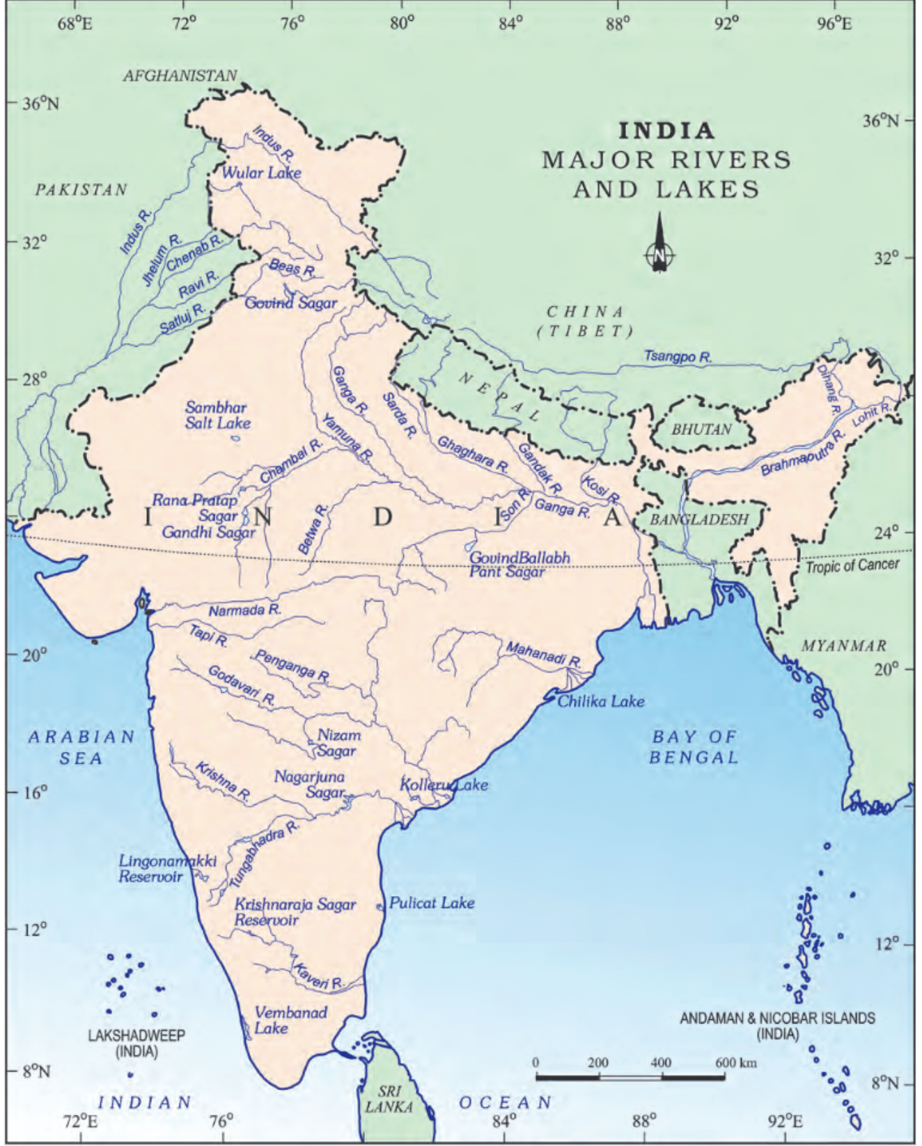
Wular lake is the largest freshwater lake in India and is situated in the Bandipora district of Jammu and Kashmir. The lake is surrounded by beautiful mountains and serves as an important habitat for various species of migratory birds.
(ii) The river Narmada has its source at
(a) Satpura
(b) Brahmagiri
(c) Amarkantak
(d) Slopes of the Western Ghats
Ans: (c) Amarkantak
Amarkantak is a pilgrimage site and a hill station located at the meeting point of the Vindhya and Satpura mountain ranges. Narmada is one of the longest rivers in India, spanning a length of approximately 1,312 kilometers. It is often referred to as the "lifeline of Madhya Pradesh" and is considered sacred by Hindus.
(iii) Which one of the following lakes is a salt water lake?
(a) Sambhar
(b) Dal
(c) Wular
(d) Gobind Sagar
Ans: (a) Sambhar
Sambhar Lake, located in the state of Rajasthan, India, is a saltwater lake. It is the largest inland saltwater lake in India and serves as a major source of salt production in the country.
(iv) Which one of the following is the longest river of the Peninsular India?
(a) Narmada
(b) Krishna
(c) Godavari
(d) Mahanadi
Ans: (c) Godavari
The Godavari River originates in the Western Ghats of Maharashtra and flows through the states of Maharashtra, Telangana, Andhra Pradesh, and eventually empties into the Bay of Bengal. The river stretches for about 1,465 kilometers (910 miles) in length, making it the longest river in Peninsular India.
(v) Which one amongst the following rivers flows through a rift valley?
(a) Mahanadi
(b) Tungabhadra
(c) Krishna
(d) Tapi
Ans: (d) Tapi
A rift valley is a long, narrow valley that is formed by the sinking and separation of the Earth's crust. The Tapi River originates in the Betul district of Madhya Pradesh and flows through Maharashtra and Gujarat before draining into the Arabian Sea.
Q2. Answer the following questions briefly.
(i) What is meant by a water divide? Give an example.
Ans: A water divide is an elevated area, like a mountain or upland, that separates two drainage basins. This means that water on either side flows into different rivers or lakes. For example, the water divide between the Indus and Ganga river systems is located at Ambala.
(ii) Which is the largest river basin in India?
Ans: The Ganga River basin is the largest in India. Key details include:
- It spans over 2,500 km.
- It covers several states, including Uttarakhand, Uttar Pradesh, Bihar, and West Bengal.
(iii) Where do the rivers Indus and Ganga have their origin?
Ans: The Indus originates in Tibet, near Mansarovar Lake. The Ganga River originates at the Gangotri Glacier, Uttarakhand on the southern slopes of the Himalayas.
(iv) Name the two headstreams of the Ganga. Where do they meet to form the Ganga?
Ans: The two headstreams of the Ganga are the Bhagirathi and the Alaknanda. They meet to form the Ganga at Devaprayag in Uttarakhand.
(v) Why does the Brahmaputra in its Tibetan part have less silt, despite a longer course?
Ans: The Brahmaputra River in its Tibetan region has:
- A smaller volume of water.
- Less silt due to the cold and dry climate.
As the river flows into Arunachal Pradesh, India, it encounters:
- High levels of rainfall.
- Increased water and silt content.
(vi) Which two Peninsular rivers flow through trough?
Ans: The Narmada and the Tapi are the two peninsular rivers that flow through the trough.
(vii) State some economic benefits of rivers and lakes.
Ans:
Economic benefits of rivers:
- Rivers provide water, essential for various human activities.
- They support agriculture through irrigation.
- Rivers facilitate the transportation of goods and people.
- They are vital for generating electricity via hydro-power.
- Rivers contribute to the local climate and support aquatic life.
Economic benefits of lakes:
- Lakes help regulate river flow, preventing floods during heavy rains.
- They maintain a steady water supply during dry seasons.
- Lakes enhance the local climate and support biodiversity.
- They attract tourism and provide recreational opportunities.
- Lakes are also used for generating hydroelectricity.
Q3. Below are given names of a few lakes of India. Group them under two categories − natural and created by human beings.
(a) Wular
(b) Dal
(c) Nainital
(d) Bhimtal
(e) Gobind Sagar
(f) Loktak
(g) Barapani
(h) Chilika
(i) Sambhar
(j) Rana Pratap Sagar
(k) Nizam Sagar
(l) Pulicat
(m) Nagarjuna Sagar
(n) Hirakund
Ans: Natural Lakes
(a) Wular
(b) Dal
(c) Nainital
(d) Bhimtal
(f) Loktak
(g) Barapani
(h) Chilika
(i) Sambhar
(l) Pulicat
Lakes created by human beings
(e) Gobind Sagar
(j) Rana Pratap Sagar
(k) Nizam Sagar
(m) Nagarjuna Sagar
(n) Hirakund
Q4. Discuss the significant difference between the Himalayan and the Peninsular rivers.
Ans: 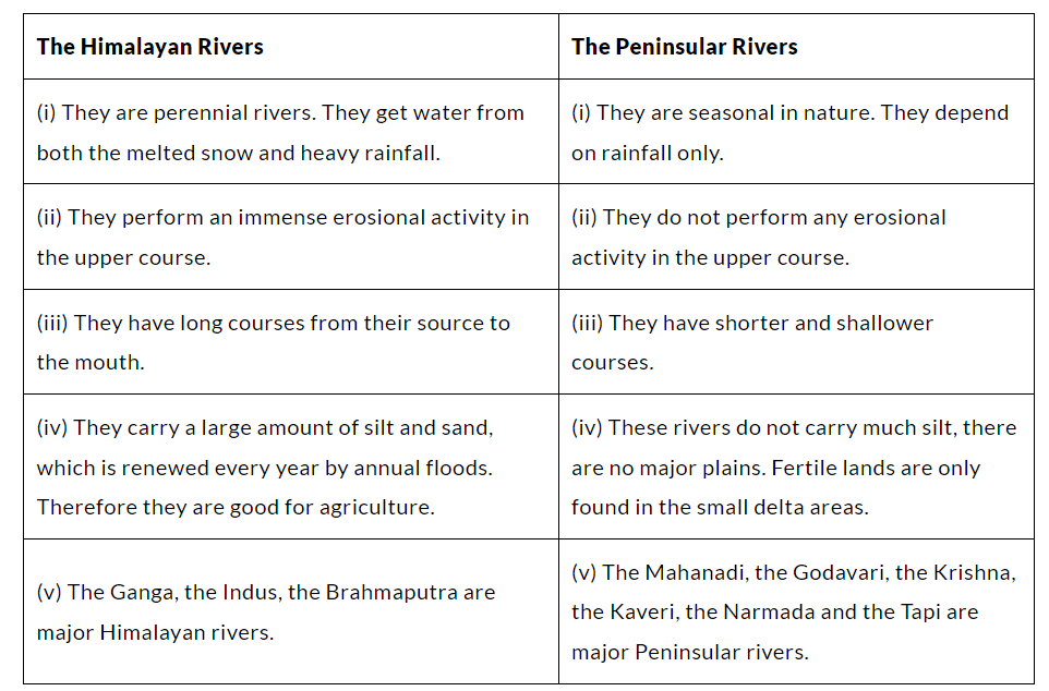
Q5. Compare the east-flowing and the west-flowing rivers of the Peninsular Plateau.
Ans: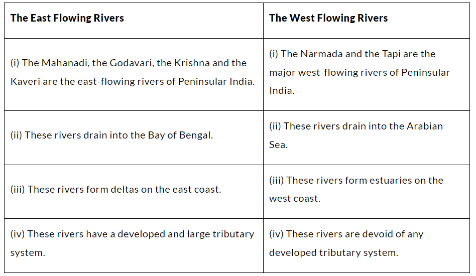
Q6. Why are rivers important for the country’s economy?
Ans:
Rivers play a vital role in a country's economy for several reasons:
- They are a key source of freshwater, essential for the survival of humans and wildlife.
- River water is used for domestic, industrial, and agricultural purposes.
- They facilitate trade and commerce by enabling the transport of goods.
- Rivers are potential sources of energy, particularly for hydroelectric power.
- They support navigation and transport, which are crucial for commercial activities.
- Rivers provide fishing opportunities and enhance scenic beauty, making them attractive for tourism.
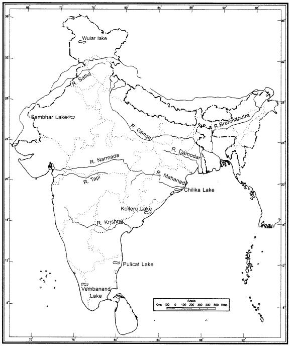
Q. (i) On the outline map of India mark and label the following rivers: Ganga, Satluj, Damodar, Krishna, Narmada, Tapi, Mahanadi, and the Brahmaputra.
(ii) On an outline map of India mark and label the following lakes: Chilika, Sambhar, Wular, Pulicat, Kolleru
Ans:
A water divide is an elevated area, like a mountain or upland, that separates two drainage basins. This means that water on either side flows into different rivers or lakes. For example, the water divide between the Indus and Ganga river systems is located at Ambala.
The document NCERT Solutions for Class 9 Geography Chapter 3 - Drainage is a part of the Class 9 Course Social Studies (SST) Class 9.
All you need of Class 9 at this link: Class 9
|
56 videos|439 docs|80 tests
|


FAQs on NCERT Solutions for Class 9 Geography Chapter 3 - Drainage
| 1. What is drainage in the context of geography? |  |
| 2. What are the different types of drainage systems? | |
Ans. The different types of drainage systems include surface drainage, subsurface drainage, and combined drainage systems. Surface drainage involves the removal of excess water from the surface through ditches or channels, while subsurface drainage uses pipes to drain water below the surface. Combined drainage systems incorporate both methods for effective water management.
| 3. How does drainage affect agriculture? | |
Ans. Efficient drainage is crucial for agriculture as it helps prevent waterlogging, which can damage crops and lead to decreased yields. Proper drainage systems can improve soil aeration, enhance root development, and promote the overall health of crops, leading to better agricultural productivity.
| 4. What is a watershed and its significance in drainage? | |
Ans. A watershed is an area of land that drains rainwater or snow into a single body of water, such as a river, lake, or ocean. The significance of a watershed in drainage lies in its ability to collect and manage water flow, ensuring that water is efficiently directed and that ecosystems are maintained.
| 5. How do human activities impact drainage systems? | |
Ans. Human activities, such as urbanization, deforestation, and agriculture, can significantly impact drainage systems. Urban development often leads to increased impervious surfaces, resulting in higher runoff and potential flooding. Deforestation can disrupt natural drainage patterns, while agricultural practices may alter soil structure, affecting water absorption and drainage efficiency.
About this Document

17K Views

4.64/5
Rating

Mar 27, 2025
Last updated
Document Description: NCERT Solutions: Drainage for Class 9 2025 is part of Social Studies (SST) Class 9 preparation.
The notes and questions for NCERT Solutions: Drainage have been prepared according to the Class 9 exam syllabus. Information about NCERT Solutions: Drainage covers topics
like and NCERT Solutions: Drainage Example, for Class 9 2025 Exam. Find important definitions, questions, notes, meanings, examples, exercises and tests below for NCERT Solutions: Drainage.
Introduction of NCERT Solutions: Drainage in English is available as part of our Social Studies (SST) Class 9
for Class 9 & NCERT Solutions: Drainage in Hindi for Social Studies (SST) Class 9 course.
Download more important topics related with notes, lectures and mock test series for Class 9
Exam by signing up for free. Class 9: NCERT Solutions for Class 9 Geography Chapter 3 - Drainage
Description
Full syllabus notes, lecture & questions for NCERT Solutions for Class 9 Geography Chapter 3 - Drainage - Class 9 | Plus excerises question with solution to help you revise complete syllabus for Social Studies (SST) Class 9 | Best notes, free PDF download
Information about NCERT Solutions: Drainage
In this doc you can find the meaning of NCERT Solutions: Drainage defined & explained in the simplest way possible. Besides explaining types of
NCERT Solutions: Drainage theory, EduRev gives you an ample number of questions to practice NCERT Solutions: Drainage tests, examples and also practice Class 9
tests

Related Searches
study material
,Sample Paper
,Summary
,Previous Year Questions with Solutions
,ppt
,MCQs
,Viva Questions
,mock tests for examination
,Semester Notes
,video lectures
,NCERT Solutions for Class 9 Geography Chapter 3 - Drainage
,shortcuts and tricks
,Free
,practice quizzes
,NCERT Solutions for Class 9 Geography Chapter 3 - Drainage
,Exam
,NCERT Solutions for Class 9 Geography Chapter 3 - Drainage
,Extra Questions
,Important questions
,Objective type Questions
,past year papers
;


Additional Information about NCERT Solutions: Drainage for Class 9 Preparation
NCERT Solutions: Drainage Free PDF Download
The NCERT Solutions: Drainage is an invaluable resource that delves deep into the core of the Class 9 exam.
These study notes are curated by experts and cover all the essential topics and concepts, making your preparation more efficient and effective.
With the help of these notes, you can grasp complex subjects quickly, revise important points easily,
and reinforce your understanding of key concepts. The study notes are presented in a concise and easy-to-understand manner,
allowing you to optimize your learning process. Whether you're looking for best-recommended books, sample papers, study material,
or toppers' notes, this PDF has got you covered. Download the NCERT Solutions: Drainage now and kickstart your journey towards success in the Class 9 exam.
Importance of NCERT Solutions: Drainage
The importance of NCERT Solutions: Drainage cannot be overstated, especially for Class 9 aspirants.
This document holds the key to success in the Class 9 exam.
It offers a detailed understanding of the concept, providing invaluable insights into the topic.
By knowing the concepts well in advance, students can plan their preparation effectively.
Utilize this indispensable guide for a well-rounded preparation and achieve your desired results.
NCERT Solutions: Drainage Notes
NCERT Solutions: Drainage Notes offer in-depth insights into the specific topic to help you master it with ease.
This comprehensive document covers all aspects related to NCERT Solutions: Drainage.
It includes detailed information about the exam syllabus, recommended books, and study materials for a well-rounded preparation.
Practice papers and question papers enable you to assess your progress effectively.
Additionally, the paper analysis provides valuable tips for tackling the exam strategically.
Access to Toppers' notes gives you an edge in understanding complex concepts.
Whether you're a beginner or aiming for advanced proficiency, NCERT Solutions: Drainage Notes on EduRev are your ultimate resource for success.
NCERT Solutions: Drainage Class 9 Questions
The "NCERT Solutions: Drainage Class 9 Questions" guide is a valuable resource for all aspiring students preparing for the
Class 9 exam. It focuses on providing a wide range of practice questions to help students gauge
their understanding of the exam topics. These questions cover the entire syllabus, ensuring comprehensive preparation.
The guide includes previous years' question papers for students to familiarize themselves with the exam's format and difficulty level.
Additionally, it offers subject-specific question banks, allowing students to focus on weak areas and improve their performance.
Study NCERT Solutions: Drainage on the App
Students of Class 9 can study NCERT Solutions: Drainage alongwith tests & analysis from the EduRev app,
which will help them while preparing for their exam. Apart from the NCERT Solutions: Drainage,
students can also utilize the EduRev App for other study materials such as previous year question papers, syllabus, important questions, etc.
The EduRev App will make your learning easier as you can access it from anywhere you want.
The content of NCERT Solutions: Drainage is prepared as per the latest Class 9 syllabus.
|
© EduRev
|
Education Revolution
|


|


Signup to see your scores
go up within 7 days!
Access 1000+ FREE Docs, Videos and Tests
Takes less than 10 seconds to signup