NCERT Solutions for Class 6 Geography - Maps

Q1. Answer the following questions briefly:
(a) What are the three components of a map?
Ans: The three components of the map are:
- Distance- Maps are drawings, which reduce the entire world or a part of it to fit on a sheet of paper. Therefore, a scale is chosen for this purpose. Scale is the ratio between the actual distance on the ground and the distance shown on the map.
- Direction- Most maps contain an arrow marked with the letter ‘N’ at the upper right-hand corner. This arrow shows the northern direction. It is called the north line. When you know the north, you can find out other directions, for example east, west and south.
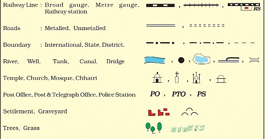
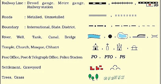
- Symbol- It is not possible to draw on a map the actual shape and size of different features such as buildings, roads, bridges, trees, railway lines or a well. So, they are shown by using certain letters, shades, colours, pictures and lines.
(b) What are the four cardinal directions?
Ans: The four cardinal directions are—North, South, East and West 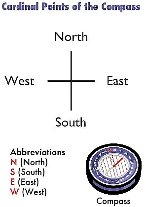
(c) What do you mean by the term ‘the scale of the map’?
Ans:
- Scale is the ratio between the actual distance on the ground and the distance shown on the map.
- For example, the distance between your school and your home is 10 km. If you show this 10 km distance by 2 cm on a map, it means, 1 cm on the map will show 5 km on the ground. The scale of your drawing will be 1cm = 5 km.
- Thus, scale is very important in any map. If you know the scale, you will be able to calculate the distance between any two places on a map.
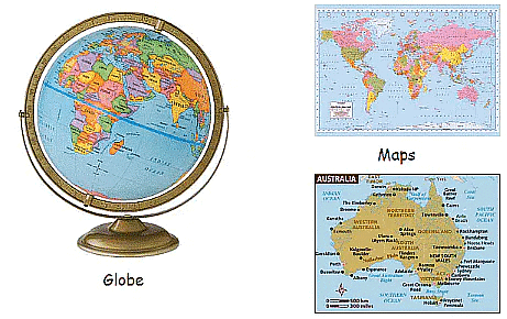
(d) How are maps more helpful than a globe?
Ans:
- Maps provide more information than a globe.
- A globe can be useful when we want to study the earth as a whole.
- But when we want to study only a part of the earth, as in a country or a state, the globe is of little help. In such situations, maps are helpful.
- A map is a representation or a drawing of the earth's surface or a part of it drawn on a flat surface according to a scale. It is impossible to flatten a round shape and scale it. Therefore, maps are more helpful than a globe.
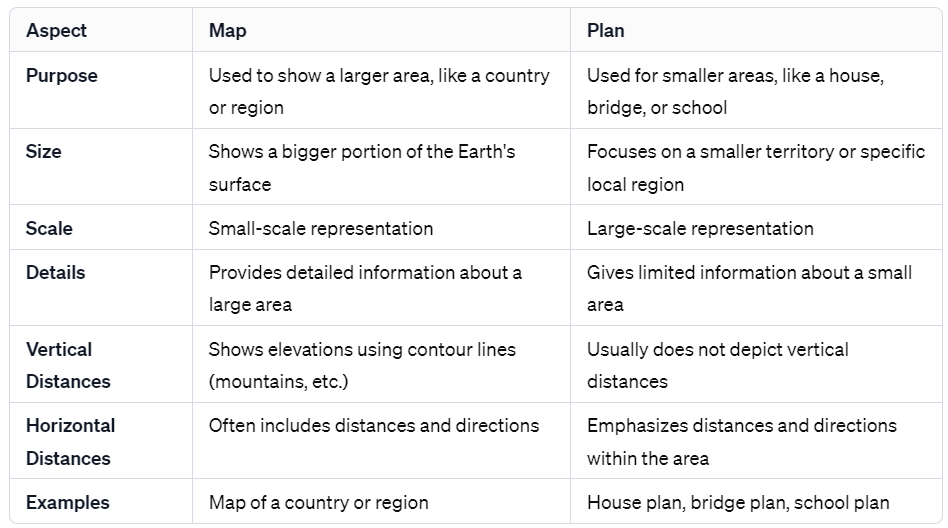
(e) Distinguish between a map and a plan.
Ans:
(f) Which map provides detailed information?
Ans: Large-scale maps provide detailed information for the following reasons:
- Large-scale maps are drawn on big-sized papers.
- Maps are of very large size.
- They have more space to depict more information.
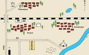 An example of a large scale map
(g) How do symbols help in reading map?
Ans: With the use of symbols maps are more informative and easier to read because of the following reasons:
- The symbols are of the features in true form.
- Language does not put any problem in understanding the feature.
- Even the less educated can understand the information easily.
Q2. Tick the correct answer:
(a) Maps showing the distribution of forests are
(i) Physical map
(ii) Thematic map
(iii) Political map
(ii) Thematic Map
Ans: (ii) Thematic map
Thematic maps focus on specific pieces of information such as roads, rainfall distribution, forests, etc.
(b) The blue colour is used for showing
(i) Water bodies
(ii) Mountains
(iii) Plains
Ans: (i) Water bodies
Blue is synonymous with water. Thus, the colour blue is used to depict water bodies on maps.
(c) A compass is used
(i) To show symbols
(ii) To find the main direction
(iii) To measure distance
Ans: (ii) To find the main direction
A compass is a tool for finding direction. A simple compass is a magnetic needle mounted on a pivot, or short pin. The needle, which can spin freely, always points north. The pivot is attached to a compass card.
(d) A scale is necessary
(i) For a map
(ii) For a sketch
(iii) For symbols
Ans: (i) For a map
The scale of a map is the relationship or ratio between the actual distance on the land to the distance given on a map. It is necessary to depict the landforms in the right proportion as well as to calculate the actual distance between any two places on the map.
|
297 videos|1065 docs|204 tests
|
FAQs on NCERT Solutions for Class 6 Geography - Maps
| 1. What is the importance of studying maps in Class 6? |  |
| 2. How can maps be used to understand the distribution of resources? | |
| 3. What are the different types of maps studied in Class 6? | |
| 4. How can maps help in understanding historical events? | |
| 5. How can one use maps for navigation and planning routes? | |


ppt
,Semester Notes
,Free
,NCERT Solutions for Class 6 Geography - Maps
,Objective type Questions
,MCQs
,Extra Questions
,NCERT Solutions for Class 6 Geography - Maps
,Previous Year Questions with Solutions
,study material
,NCERT Solutions for Class 6 Geography - Maps
,Sample Paper
,video lectures
,practice quizzes
,Important questions
,Exam
,past year papers
,Summary
,Viva Questions
,shortcuts and tricks
,mock tests for examination
;


NCERT Solutions: Maps Free PDF Download
Importance of NCERT Solutions: Maps
NCERT Solutions: Maps Notes
NCERT Solutions: Maps Class 6 Questions
Study NCERT Solutions: Maps on the App
|
© EduRev
|
Education Revolution
|


|


within 7 days!