Class 12 Geography Short Questions with Answers- International Trade

Q1: What is meant by the balance of Trade?
Ans: The balance of trade refers to the difference between the value of a country's imports and exports. It can be summarised as follows:
- If exports exceed imports, there is a trade surplus.
- If imports exceed exports, there is a trade deficit.
- The balance of trade is a key indicator of a country's economic health.
Q2: What is meant by international trade?
Ans: The exchange of goods and services between countries is known as international trade. This trade allows nations to:
- Access products not available domestically.
- Sell their goods to a larger market.
- Enhance economic growth and development.
Overall, international trade is crucial for fostering global economic relationships.
Q3: How is the favourable balance of trade an indicator of the economic development of a country?
Ans: A favourable balance of trade occurs when a country's exports exceed its imports. This situation can indicate economic development in several ways:
- It reflects a strong export sector, which can lead to job creation and economic growth.
- A positive balance can enhance foreign exchange reserves, providing stability to the economy.
- It may attract foreign investment, as investors seek to capitalise on a thriving economy.
Overall, a favourable balance of trade is a key sign of a country's economic health and growth potential.
Q4: Why is the export of agricultural and allied products declining continuously after 1997-98?
Ans: The decline in the export of agricultural and allied products is primarily due to:
- Tough international competition from countries like China and other East Asian nations.
- A decrease in the export of traditional items, such as cashew.
- While there is growth in exports of floricultural products, fresh fruits, and marine products, traditional exports are struggling.
- The overall share of agricultural products in India's exports has diminished over the years.
Q5: Name any two products that have registered an increased growth in the export list.
Ans: Floricultural products and fresh fruits have seen significant growth in exports.
- Floricultural products
- Fresh fruits
- Marine products
- Sugar
Q6: Why has there been an increase in the trade deficit over the last couple of years?
Ans: The increase in the trade deficit is mainly due to the rising prices of crude petroleum, which is a significant part of India's imports. Key points include:
- Crude petroleum prices have surged.
- India relies heavily on imports for energy needs.
- The value of imports has consistently outpaced exports.
Q7: Name the two countries that are the largest trading partners of India as per the economic survey report of 2011-12. [Old NCERT]
Ans: UAE China
Q8: Mention the characteristics of India’s foreign trade.
Ans: Characteristics of India's Foreign Trade
- India's share in total world trade is only 1.6% (2017-18), with about 90% of trade conducted via sea.
- The country's large population results in a low per capita foreign trade compared to developed and developing nations.
- India has an unfavourable balance of trade, importing more than it exports.
- Currently, India exports to over 200 countries and imports from more than 180 countries.
Q9: What are the causes of the trade imbalance in India? [Old NCERT]
Ans: The causes of India's trade imbalance include:
- High prices at the global level.
- Devaluation of the Indian rupee internationally.
- Slow progress in production within India.
- Rising domestic demand in India.
Q10: Define the term ‘Hinterland’ of the port. OR Explain the meaning of hinterland.
Ans: Hinterland refers to the area of land located behind a coast or river shoreline. It plays a crucial role in supporting nearby towns or cities by providing:
- Agricultural products such as fresh fruits and vegetables.
- Raw materials are needed for various industries.
- Essential supplies like milk to urban areas.
This connection ensures that cities receive high-quality, fresh products from their hinterlands.
Q11: What are naval ports? Give one example of a naval port.
Ans: Naval ports are ports that hold significant strategic importance. They are specifically designed to support and maintain warships and often include repair facilities.
- These ports focus on military operations.
- They are crucial for national security.
- Example: Karwar, located on the western coast of India.
Q12: Which port is situated on the mouth of the Zuari estuary?
Ans: Marmagao is located at the entrance of the Zuari estuary in Goa. It is a natural harbour that became important after its remodelling in 1961.
- Handles iron-ore exports, particularly to Japan.
- The construction of the Konkan railway has expanded its hinterland.
- Its hinterland includes parts of Karnataka, Goa, and southern Maharashtra.
Q13: Name the riverine port on the eastern coast of India. OR Name the major seaport located on the Hugli River.
Ans: Kolkata Port is the major riverine port located on the eastern coast of India. It is situated on the Hugli River, approximately 128 km from the Bay of Bengal.
- Originally developed by the British, it served as the capital of British India.
- It has faced challenges such as silt accumulation in the Hugli River.
- The port's hinterland includes regions like Uttar Pradesh, Bihar, and Jharkhand.
- It also provides port facilities to neighbouring land-locked countries like Nepal and Bhutan.
Q14: Which major seaport in eastern India has a landlocked harbour?
Ans: Visakhapatnam Port is a major seaport located in Andhra Pradesh, India. It features a landlocked harbour that is connected to the sea through a channel carved from solid rock and sand.
- It has an outer harbour developed for handling various types of cargo, including iron ore, petroleum, and general goods.
- The port primarily serves the hinterlands of Andhra Pradesh and Telangana.
Q15: Name the major seaport that has developed to relieve the pressure at Chennai seaport.
Ans: Ennore is a newly developed port located 25 km north of Chennai. It was constructed to:
- Relieve the pressure on Chennai Port.
- Accommodate larger vessels.
Additionally, Tuticorin Port has also been developed for similar reasons, handling various types of cargo including:
- Coal
- Salt
- Food grains
- Petroleum products
Q16: How is the importance of the seaport judged?
Ans: The importance of a port is assessed based on:
- The volume of cargo it handles.
- The number of ships it accommodates.
- The cargo quantity reflects the development level of its hinterland.
Q17: Name the major seaport which was developed just after independence on the western coast of India.
Ans: Kandla Port was developed just after India's independence on the western coast. It serves as a major seaport with significant importance for the region.
Q18: Name the seaport which was constructed to reduce the congestion at Kolkata port.
Ans: Haldia Port was constructed to alleviate congestion at Kolkata Port. It is located:
- 105 km downstream from Kolkata.
- Designed to handle bulk cargo such as:
- Iron ore
- Coal
- Petroleum and its products
- Fertilisers
- Jute and cotton products
This port plays a crucial role in improving shipping efficiency in the region.
Q19: Name the port developed as a satellite port to relieve the pressure on Mumbai Port.
Ans: Jawaharlal Nehru Port was developed as a satellite port to ease congestion at Mumbai Port. Key facts about Jawaharlal Nehru Port:
- It is located at Nhava Sheva.
- It is the largest container port in India.
- Designed to handle a significant volume of cargo.
Q20: Why was the Kandla Port constructed?
Ans: Kandla Port was constructed for several important reasons:
- To alleviate the pressure on Mumbai Port.
- To serve the needs of the western and northwestern regions of India.
- To handle large volumes of petroleum, petroleum products, and fertilisers.
Q21: Name the landlocked harbour of India.
Ans: Visakhapatnam is a landlocked harbour located in Andhra Pradesh, India. It is uniquely connected to the sea through a channel carved from solid rock and sand.
- It features an outer harbour designed for handling various goods.
- The port primarily serves the hinterland regions of Andhra Pradesh and Telangana.
- Visakhapatnam is crucial for transporting iron ore, petroleum, and general cargo.
Q22: Name the northernmost international airport of India. [Old NCERT]
Ans: The northernmost international airport in India is Amritsar.
Q23: Identify the Indian seaport which provides port facilities to its landlocked neighbour countries. Name any one such country.
Ans: The Kolkata seaport provides essential port facilities to its landlocked neighbouring countries.
- Country: Nepal
- Country: Bhutan
Q24: State the major problem being faced by the Kolkata seaport.
Ans: The major issue facing the Kolkata seaport is the accumulation of silt in the Hugli River, which connects the port to the sea. This problem affects:
- Navigation for large vessels
- Port operations and efficiency
- Overall trade capacity
Q25: State any two advantages of air transport in international trade.
Ans: Advantages of air transport in international trade:
- Speed: Air transport is the fastest method for moving goods.
- Global Reach: It allows for the rapid movement of valuable cargo worldwide.
- Connectivity: Air transport has improved access to remote areas.
- Perishables: It is ideal for transporting perishable goods over long distances.
Q26: Most of India’s foreign trade is carried through sea routes. Explain the statement giving three reasons.
Ans: Most of India’s foreign trade is carried through sea routes. India relies heavily on sea routes for foreign trade due to several reasons:
- Port Infrastructure: Ports are vital for the growth of the manufacturing and mining sectors. Industries like steel, refineries, and automobiles depend on ports for both raw materials and the export of finished goods.
- Logistics Costs: The cost of transporting large volumes of materials significantly impacts production costs and overall business profitability.
- State-Owned Ports: India has 12 major state-owned ports, which handle about 58% of the country’s external trade by volume. These ports are crucial for managing increasing imports and exports.
With the rising demand for port infrastructure, especially for imports like crude oil and coal, public ports may struggle to meet future needs. This creates opportunities for private ports to expand and cater to the growing demand.
Q27: Why is Kochi considered a major port?
Ans: Kochi is considered a major port due to several key factors:
- It has an excellent location with a natural harbour.
- It is strategically positioned near the Suez-Colombo route.
- It serves the needs of the three southern states of India.
Q28: Why is Mumbai considered as a major port source?
Ans: Mumbai is considered a major port for several reasons:
- Natural Harbour: Mumbai is a natural harbour and the largest port in India.
- Strategic Location: It is located near key trade routes from the Middle East, Mediterranean, North Africa, North America, and Europe, facilitating a significant portion of India's overseas trade.
- Oil Terminal: The port houses India's largest oil terminal, enhancing its capacity for handling petroleum products.
Q29: Why is New Mangalore Port considered important?
Ans: New Mangalore Port is significant for several reasons:
- It supports the export of iron ore and iron concentrates.
- It handles a variety of goods, including fertilisers, petroleum products, edible oils, coffee, tea, wood pulp, yarn, granite stone, and molasses.
- The port serves as a crucial hub for the Karnataka region.
Q30: Distinguish between port and harbour.
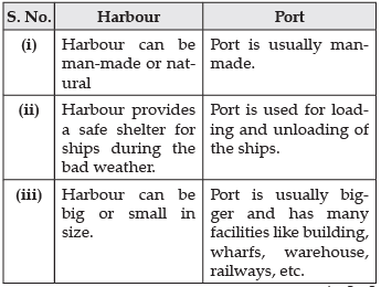
Ans: Harbour and port may appear similar, but they have distinct functions:
- Harbour: A sheltered area of water where ships can anchor safely.
- Port: A facility with infrastructure for loading and unloading ships, often including warehouses and transport links.
In summary:
- Harbours focus on safety and shelter.
- Ports facilitate trade and transportation.
Q31: Name the important items that India imports from different countries.
Ans: The total imports of India amounted to 608 crores, increasing to 3,49,931 crores in 2003-04. The main items imported include:
- Petroleum and petroleum products - 31.0%
- Food and allied products - 3.7%
- Chemicals - 6.7%
- Electrical machinery - 6.49%
- Iron and steel - 2.02%
- Fertilisers - 1.20%
Q32: Name the ports of India located on the East Coast.
Ans:
- Chennai Port: Located on the eastern coast, it serves the hinterland of Tamil Nadu, Puducherry, and parts of Karnataka. It is one of the oldest ports in India, established in 1859, but is not ideal for large ships due to its shallow waters.
- Visakhapatnam Port: Situated on the coast of Odisha, it boasts the deepest harbour in India, with a depth of 12 metres. It is a land-locked harbour, primarily serving Andhra Pradesh and Telangana.
- Paradip Port: Located in the Mahanadi Delta, about 100 km from Cuttack, this port is designed for large-scale iron ore exports. Its hinterland includes parts of Odisha, Chhattisgarh, and Jharkhand.
Q33: Why does India import edible oil and pulses despite being an agriculturally rich country?
Ans: India imports edible oil and pulses for several reasons:
- High demand: The large population creates a significant need for food.
- Land use: Much of the agricultural land is dedicated to food production.
- Low productivity: Pulses have a low yield per hectare.
- Profitability: Growing pulses is often less profitable than other crops.
- Farming risks: Agriculture faces high vulnerability to risks.
|
50 videos|273 docs|37 tests
|
FAQs on Class 12 Geography Short Questions with Answers- International Trade
| 1. What is international trade in humanities/arts? |  |
| 2. How does international trade benefit the humanities/arts industry? | |
| 3. What are the challenges faced by the humanities/arts industry in international trade? | |
| 4. How does international trade impact the preservation of cultural heritage in the humanities/arts? | |
| 5. What are the economic implications of international trade in the humanities/arts? | |


MCQs
,Semester Notes
,Free
,Important questions
,Viva Questions
,Class 12 Geography Short Questions with Answers- International Trade
,Sample Paper
,Summary
,Objective type Questions
,mock tests for examination
,ppt
,shortcuts and tricks
,past year papers
,Exam
,Class 12 Geography Short Questions with Answers- International Trade
,Class 12 Geography Short Questions with Answers- International Trade
,practice quizzes
,Extra Questions
,video lectures
,Previous Year Questions with Solutions
,study material
;


Short Questions with Answers- International Trade Free PDF Download
Importance of Short Questions with Answers- International Trade
Short Questions with Answers- International Trade Notes
Short Questions with Answers- International Trade Humanities/Arts
Study Short Questions with Answers- International Trade on the App
|
© EduRev
|
Education Revolution
|


|


within 7 days!