Textbook solutions: Weather and Climate | IGCSE Oxford Geography Foundations for Year 7 - Class 7 PDF Download

How might you observe and record the weather.
Q1. What is weather?
Ans: Weather is the state of the atmosphere at a particular place and time, including factors such as temperature, precipitation, wind, and cloudiness. It’s what you experience day-to-day and can change from hour to hour.
Q3. Describe how each of the following is measured:
Temperature
Wind Direction
Wind strength
Cloud Cover
Ans:
- Temperature: Measured using a thermometer, which can be mercury-based or digital, indicating the warmth or coldness of the atmosphere.
- Wind Direction: Determined using a wind vane or weathercock, which aligns with the wind and points in the direction from which the wind is coming.
- Wind Strength: Measured using an anemometer, which counts the number of rotations to calculate wind speed, often reported in knots, meters per second, or on the Beaufort scale.
- Cloud Cover: Observed visually and quantified in oktas, which divide the sky into eight parts. It’s also measured using ceilometers that use a laser or other light source to determine cloud height and coverage.
Q4. Make sketches of the four cloud types in D. Under each sketch write a cloud description from the following list.
• Low grey shapeless cloud that forms in layers.
• High clouds that are wispy, light and featherlike.
• Dome shaped clouds with dark flat bases.
• Huge towering clouds that often give showers.
Ans:
- Cumulonimbus: Huge towering clouds that often give showers.
- Cumulus: Dome shaped clouds with dark flat bases.
- Stratus: Low grey shapeless cloud that forms in layers.
- Cirrus: High clouds that are wispy, light and featherlike.
How can local features affect temperature and wind?
Q1. Describe a place at your school which is
a often sunny
b usually in the shade
c sheltered on a windy day.
Ans: A place at my school that is: a. Often sunny: The open courtyard facing south, where sunlight bathes the area for most of the day. b. Usually in the shade: The north side of the main building, where the tall structure casts a long shadow. c. Sheltered on a windy day: The recessed entranceway surrounded by buildings on three sides, protecting it from prevailing winds.
Q2. Copy and complete diagram D by filling in the clouds with the following words or statements:
Climate conditions of a small area
Physical features
Dark surfaces warm up most
Reduces the effect of wind
Buildings
Aspect
Ans:
Microclimate: Climate conditions of a small area Shelter: Reduces the effect of wind Surface: Dark surfaces warm up most Buildings: Give off heat and warm surroundings Aspect: Direction in which a place is facing Local weather conditions: Can affect both temperature and wind Physical features: Can include natural and man-made structuresQ3. From photo C give eight features of the school's microclimate. List your answers under the headings:
Aspect
Shelter
Others
Ans:
Aspect:
- Sun at midday indicates the school’s orientation allows for maximum sunlight around noon.
- Hotter classrooms on the sunny side of the school show the impact of aspect on indoor temperatures.
Shelter:
- Play area sheltered from wind suggests buildings or structures provide a windbreak.
- Cooler classrooms due to shade and effect of wind indicate that certain areas are protected from direct sunlight and wind chill.
Others:
- Cool in trees with less wind highlights the cooling effect of shaded areas with vegetation.
- Cool around the edge of the lake demonstrates the cooling influence of water bodies.
- Play area warmed by dark tarmac surface shows how surface color affects microclimate.
- Some warmth from building suggests that buildings can radiate stored heat.
What is Britain's weather?
Q1. What is the difference between weather and climate?
a Write out and complete the following sentence to describe summer temperatures in Britain.
Summers in Britain are ______ than winter. The warmest weather is in the _____ and temperatures get lower (decrease) towards the ______.
b Write a similar sentence to describe winter temperatures.
Ans:
The difference between weather and climate is that weather refers to the short-term conditions of the atmosphere at a specific time and place, including temperature, humidity, precipitation, cloudiness, visibility, and wind. In contrast, climate is the average of these conditions over longer periods and a wider area.
a. Summers in Britain are warmer than winter. The warmest weather is in the south and temperatures get lower (decrease) towards the north.
b. Winters in Britain are colder than summer. The coldest weather is in the north and temperatures get milder (increase) towards the south.
Q2. Why are there temperature differences in Britain?
Ans:
There are temperature differences in Britain due to:
- Latitude: Northern parts are cooler because they are further from the equator.
- Altitude: Higher areas like the Scottish Highlands are colder.
- Ocean Currents: The Gulf Stream brings warmer water to the west, affecting nearby land temperatures.
Q3. Think of three reasons and write them in your workbook.
Ans:
Three reasons for temperature differences in Britain could include:
- Proximity to the Sea: Coastal areas tend to have milder temperatures than inland areas.
- Urban Heat Islands: Cities can be warmer than surrounding rural areas due to human activities and infrastructure.
- Prevailing Winds: Winds from different directions can bring warm or cold air.
Q4. List the three wettest and the three driest towns from map D. Give your answers in order with the wettest first, With the help of a simple diagram, describe the difference in rainfall from east to west. Give actual figures in your answer.
Ans:
The three wettest towns from Map D, starting with the wettest, are:
- Fort William - 2,000mm
- Glasgow - 1,560mm
- Keswick - 1,480mm
The three driest towns, starting with the driest, are:
- London - 510mm
- Norwich - 650mm
- Newcastle - 630mm
The difference in rainfall from east to west can be illustrated with a simple diagram showing increasing rainfall as you move from the drier east to the wetter west, influenced by the orographic effect as moist air rises over higher ground in the west.
Q5. Make a large copy of map E.
Match the following climate descriptions to A, B, C and D and write them on your map. A has been done on the map to help you.
Warm summers, cold winters, dry
Mild summers, mild winters, wet
Warm summers, mild winters, quite wet
Mild summers, cold winters, dry
c Suggest reasons for the climate of area A
d Mark where you live on your copy of map E.
e Describe the climate there and suggest reasons for it.
Ans:
Matching climate descriptions to Map E:
- A: Warm summers, cold winters, dry (Already done on the map)
- B: Mild summers, mild winters, wet
- C: Warm summers, mild winters, quite wet
- D: Mild summers, cold winters, dry
c. The climate of area A could be due to its inland location away from moderating sea influences, leading to greater temperature extremes and less precipitation.
d. (You would mark your location on your copy of Map E.)
e. The climate where you live can be described based on its latitude, altitude, distance from the sea, and prevailing winds. For example, if you live in the south of England, you might experience mild winters and warm summers due to the influence of the Gulf Stream and being closer to the equator. If you live in the north, the climate might be cooler with more rainfall due to higher altitudes and latitude.
How does it rain?
Q1. Match the beginnings of the labels in E to their correct endings.
Ans:
- Clouds are made up of tiny drops of moisture called cloud droplets.
- Precipitation is rain, snow, and other forms of moisture in the sky.
- Condensation happens when water vapor changes to water.
Q2. With the help of a labelled diagram, describe how it rains.
Ans: 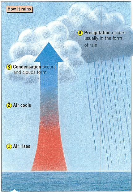
Q3. a. Make larger copies of the three diagrams in F.
For each diagram explain how it rains by adding labels at points 1, 2, 3 and 4.
Add colour to make your diagrams clearer.
Underneath each of your diagrams give a brief reason for the air rising.
Give each diagram a title.
Ans: 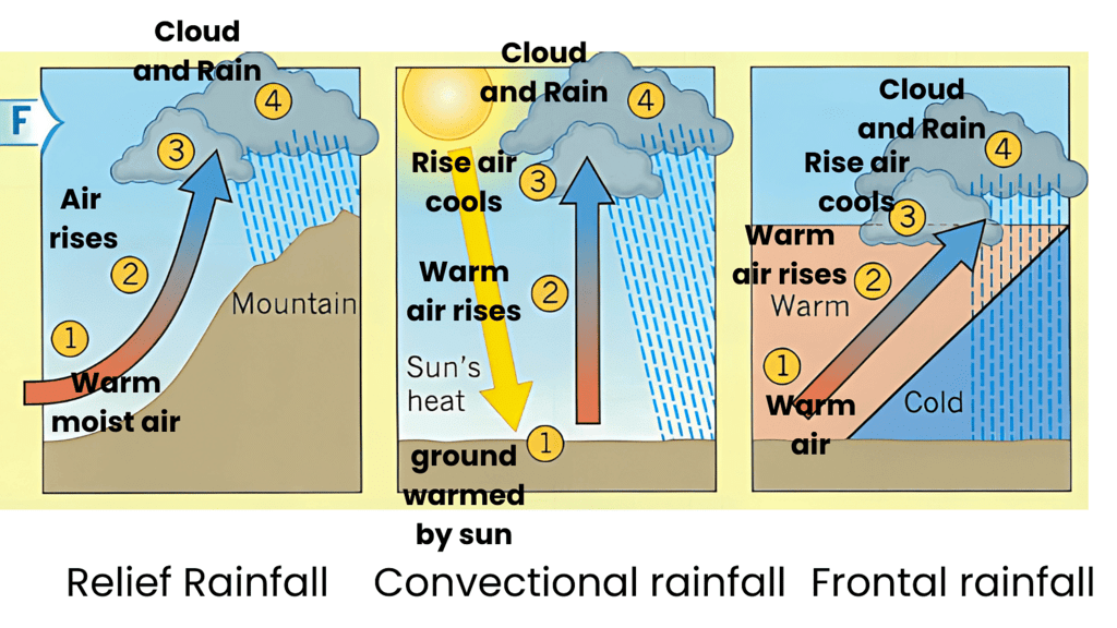
Q4. Explain why Seathwaite is wetter than Newcastle.
Use diagram B to help you.
Ans:
- Seathwaite is wetter than Newcastle primarily due to the phenomenon of relief rainfall, which is also known as orographic rainfall1. This type of rainfall occurs when moist air is forced to rise over high land such as hills or mountains. As the air rises, it cools and condenses, forming clouds and precipitation2.
- In the context of the north of England, the prevailing winds come from the west and carry moisture from the Atlantic Ocean. When these moist winds encounter the upland areas, like the Lake District where Seathwaite is located, they are forced upwards by the terrain. The air cools as it ascends, leading to the formation of rain clouds and resulting in high levels of precipitation. Seathwaite, being in the heart of the Lake District, receives some of the highest rainfall in England due to this process3.
- On the other hand, Newcastle is situated further east and is in the rain shadow created by the Pennines. After the air has passed over the higher ground and dropped its moisture on the western side, it descends and warms on the eastern side, leading to drier conditions4. This is why Newcastle, being on the leeward side of the Pennines, receives significantly less rainfall compared to Seathwaite.
Forecasting the weather - anticyclones
Q1. From map A, give the weather that is forecast for the place where you live.
Ans: 21 degree sunny
Q2. When do you think it would be useful for you to know the next day's weather?
Make a list of people who need the weather forecast. For each person explain why they need to know about the weather.
Ans:
Knowing the next day’s weather can be useful for various reasons, such as planning outdoor activities, dressing appropriately, or preparing for potential hazards. Here’s a list of people who need the weather forecast and why:
- Farmers: To plan agricultural activities like planting, harvesting, and protecting crops from adverse weather.
- Construction Workers: To schedule building activities and ensure safety on-site during poor weather conditions.
- Event Organizers: To prepare for outdoor events, ensuring attendee comfort and safety.
- Pilots and Airline Operators: For safe flight planning and avoiding turbulent weather.
- Commuters: To anticipate travel delays due to weather conditions like snow or heavy rain.
- Emergency Services: To prepare for and respond to weather-related emergencies and natural disasters.
Q3. How do satellites help in forecasting
weather conditions?
Ans: Satellites help in forecasting weather conditions by providing a wide range of data from space, including cloud cover, storm systems, temperature, and humidity levels. They offer a global perspective, allowing meteorologists to track weather patterns and predict their movements and developments.
Q4. a Make a sketch of an anticyclone like the one in diagram D above.
b Next to your sketch, write out the paragraph below and fill in the blank spaces with the following words:
• LONG •LARGE • HIGH •COOL
Anticyclones are areas of pressure which form when air sinks. They usually cover periods of areas and give fine settled weather.
Ans: Anticyclones are areas of HIGH pressure which form when air sinks. They usually cover LARGE periods of areas and give fine settled COOL weather.
Q5. Copy and fill in table F to show the weather features of an anticyclone.
table F- 
Ans:
Forecasting the weather - depressions
Q1. The words below have been jumbled up. Unscramble the words and fill in the blank spaces in the following paragraph.
NIRA SATE DULOC OWL TEWS SERIS
Depressions are areas of ____ pressure which form when air ____. They usually move across Britain from ______ to ______ and bring most of our ________ and ___________
Ans:
- RAIN
- EAST
- COULD
- LOW
- WEST
- RISES
Filling in the blanks: Depressions are areas of low pressure which form when air rises. They usually move across Britain from west to east and bring most of our rain and clouds.
Q2. With the help of a labelled diagram, explain why depressions bring cloud and rain.
Ans: 
Q3. Make a labelled sketch of a depression like the one shown in diagram B. Underneath your sketch make a copy of the table below.
Complete the table to show the main features of a depression.
| General Features | Weather |
Ans:
Q4. From diagram D:
a. Describe the weather at place X for 6 a.m., 12 midday and 6 p.m.
b. Explain why the weather has changed.
c. At what time will the warm front be over the place where you live?
d. Describe the weather you may get at that time.
Ans:
a. Weather at place X:
- 6 a.m.: Likely dry and mainly fine with increasing clouds from the west.
- 12 midday: Cloudy with steady rain and strong winds changing from south to south-west.
- 6 p.m.: After stormy showery weather, it becomes colder and finer with winds from the north-west.
b. Why the weather has changed: The weather has changed due to the movement of a depression, typically characterized by a sequence of weather changes associated with a low-pressure system. This includes the passage of warm and cold fronts, leading to variations in wind direction and weather conditions.
c. Time warm front will be over your location: Without specific timings provided in Diagram D, it’s not possible to determine the exact time the warm front will be over your location. However, the approach of clouds from the west with increasing winds from the south typically indicates the arrival of a warm front.
d. Weather during the warm front: When the warm front is over your location, you can expect cloudy skies with steady rain. The temperature may rise slightly, and winds will generally be strong, possibly changing from south to south-west
|
13 videos|18 docs|5 tests
|
FAQs on Textbook solutions: Weather and Climate - IGCSE Oxford Geography Foundations for Year 7 - Class 7
| 1. How can one observe and record the weather? |  |
| 2. How can local features affect temperature and wind? | |
| 3. What is Britain's weather like? | |
| 4. How does rain occur? | |
| 5. How are anticyclones and depressions used in weather forecasting? | |


Summary
,video lectures
,MCQs
,Important questions
,study material
,Previous Year Questions with Solutions
,mock tests for examination
,shortcuts and tricks
,past year papers
,Extra Questions
,Exam
,Sample Paper
,ppt
,Semester Notes
,practice quizzes
,Free
,Viva Questions
,Textbook solutions: Weather and Climate | IGCSE Oxford Geography Foundations for Year 7 - Class 7
,Textbook solutions: Weather and Climate | IGCSE Oxford Geography Foundations for Year 7 - Class 7
,Objective type Questions
,Textbook solutions: Weather and Climate | IGCSE Oxford Geography Foundations for Year 7 - Class 7
;


Textbook solutions: Weather and Climate Free PDF Download
Importance of Textbook solutions: Weather and Climate
Textbook solutions: Weather and Climate Notes
Textbook solutions: Weather and Climate Class 7 Questions
Study Textbook solutions: Weather and Climate on the App
|
© EduRev
|
Education Revolution
|


|


