Long Question Answers: Climate | Geography Class 11 - Humanities/Arts PDF Download
Q. 1. What are Monsoons? How are these caused? Describe the winter and summer monsoons.
Ans. Monsoons. The word monsoon is derived from the Arabic word ‘mausam’ which means season. These monsoon winds are seasonal winds. The term was first used for the monsoon winds, blowing over the Arabian Sea. In this wind system there is a reversal of wind direction according to seasons. In summer, monsoons blow from sea to land and in winter monsoons blow from land to sea.
Origin. Monsoons are land and sea breezes on large scale. These winds have a thermal origin. These are caused from the differential heating and cooling of land and water. The chain of events is from temperature through pressure and winds to rainful. In summer, the land gets more heated than sea resulting in a low pressure on the land masses and a high pressure over seas. The winds blow from sea to land. In winter the conditions are reversed and winds blow from land to sea. Land wave breeze and sea-breeze follow a daily rhythm over a small coastal areas, but the monsoons follow a seasonal rhythm over a large area.
Necessary conditions. The monsoons are developed under the following conditions :
(1) The presence of the large land mass (continent).
(2) The presence of a large ocean.
(3) Long coast line.
(4) Seasonal extremes of temperature of land and water.
Areas. Monsoons mostly blow in tropical areas. The Himalayas separate these areas into two parts :
(1) East Asia monsoons blowing over China, Japan and Indo-China.
(2) Indian Monsoons of India, Pakistan, Bangla Desh and Burma.
Summer Monsoons. The sun is vertical at the Tropic of Cancer. Rapid heating in the hot summer over Asia, gives rise to the low pressure in the Central Asia and North West India. There is high pressure over the oceans. So sea to land winds blow. These are known as S.W. Summer monsoons in India. These onshore winds give heavy and sudden rainfall, which is often termed as ‘The burst of monsoon’. The heavy rainfall is due to the presence of high mountains, convectional rising of winds and cyclonic activities. The rainfall is highly variable and uncertain. It is rightly said that, “Indian budget is a gamble on monsoons.” New Concept. According to Flohn, “The tropical monsoon is simply a modification of the general planetry wind system. The low pressure system of Northern India is a northward extension of the equatorial low (N.I.T.C.). The S.E. Trade winds after crossing the equator become south-west during summer monsoons. During the winter N.I.T.C. (Northern Inter Tropical Convergence) moves southward and the normal trade winds are reestablished as the N.E. winter monsoons.
Winter Monsoons. In winter the land mass of Asia becomes cold while the adjoining oceans are comparatively warm. High pressure develops over Central Asia and North-West India. It results in a reversal of wind directions so that land to sea winds blow. These are mostly dry and are known as North East monsoon in India. After crossing Bay of Bengal, these winds give rainfall over south-east coast of India.
Q. 2. Describe the climatic conditions which prevail over India during different seasons.
Ans. SEASONS. The Indian sub-continent has a tropical monsoon climate. India has a broad unity of monsoon type of the climate having a same rhythm of seasons. The advance and retreat of monsoons divide the weather into different seasons.
Seasons :
(A) Seasons of N.E. Monsoons :
(i) The Cold Seasons. January to February
(ii) The Hot Seasons. March to May
(B) Seasons of S.W. Monsoons :
(iii) The Rainy Season. June to September.
(iv) The Season of Retreating Monsoon.
October to December.
I. The Cold Season. The cold season lasts from January to February.
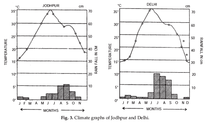
(a) Temperature. The sun is over head at Tropic of Capricorn. The Indian sub-continent has winter season. January is the coldest month. The southern parts have warm conditions (20°C) while low temperatures (10°C) are found in N.W. India and the Trans-Himalayan region of J & K which are the coldest parts of India. The minimum temp. of – 50°C are recorded at Dras or Kargil (Ladakh).
(b) Pressure and Winds. High pressure is developed over N.W. part while a low pressure exists over Indian Ocean with the result winds blow from land to sea.
(c) Rainfall. The N.E. Monsoons are off-shore winds are dry. But these winds pick up some moisture while crossing Bay of Bengal and give rain to S.E. coast of India. Some cyclones from Mediterranean Sea also bring a small amount of rain (10 to 20 cm.) to Northern plains. Leh (Ladakh) gets moderate rainfall in winter and has precipitation throughout the year in one form or the other. Night Frost is common in the N.W. part.
II. The Hot Season. The hot season lasts from March to May.
(a) Temperature. As the sun’s rays fall vertical over Tropic of Cancer, the temperature begins to rise. The average temperature is above 30° C, the maximum temperature rises to 50° C in Barmer (Rajasthan). The daily range of temperature rises in inland areas.
(b) Pressure and Winds. Intense heat results in the development of low pressure (monsoon low pressure trough) over N.W. India and Pakistan. A high pressure exists over Indian Ocean. S.W. Monsoons begin to blow from sea to land. ‘Nor-Westers’ and ‘Loo’ blow over Northern plains.
(c) Rainfall. Some areas receive convectional rainfall. The west coast also starts receiving rainfall. Most of the country is dry in the pre-Monsoon period.
III. The Rainy Season. The rainy season lasts from June to September.
(a) Temperature. The sun shines vertical over Tropic of Cancer. The temperature is more than 30° C. With the on-set of monsoon, there is a drop in temperature (5° to 10°) with the result, July is not the hottest month.
(b) Pressure and Winds. S.W. Monsoons blow from sea to land with a ‘burst’ on the West coast. It blows in two currents : (i) Arabian sea current (ii) Bay of Bengal current. (c) Rainfall. S.W. Monsoons are rain giver. The Arabian sea branch gives heavy rainfall on the west coast, but Deccan plateau lies in the rain shadow of western ghats. The Bay of Bengal branch gives heavy rainfall in Eastern Himalayas. Rajasthan is practically a desert.
IV. The Season of Retreating Monsoon. S.W. Monsoons begin to withdraw from the subcontinent during the first week of October. This is a transition period from hot rainy season to dry winter. The direction of monsoon is reversed. These dry winds are called retreating monsoons. The sun begins to move towards equator. There is a decrease in temperature. Hot and sticky weather is found. High day temperatures causes unpleasant weather called ‘October heat’. Some tropical cyclones are developed which give heavy rainfall in coastal areas. Cool weather begins in N.W. India, but the Southern parts have an equable climate. The Monsoonal Unity of India. There is a great diversity of climatic conditions of India due to vast size and difference in relief. But the monsoonal rhythm of seasons is great unifying force in India. Monsoons control the climatic conditions all over India. The distribution of rainfall is seasonal. Agriculture depends upon monsoonal rainfall resulting in a subsistence agriculture. Agriculture in India is a gamble on monsoons. The folk songs like Kajari of Bhojpur and Malhar of Braj are associated with monsoonal rains. Thus Monsoons provide a natural base for a uniformity throughout the country. The Indian landscape, its animals and plants, agricultural calendar (Kharif and Rabi seasons) life of the people and their festivals revolve around monsoons.

Q. 3. Discuss the chief features of the summer monsoon rainfall and its significance in the agricultural economy of the country.
Ans. The average annual rainfall in India is about 110 cms. It is estimated that more than 85% or this rainfall is received in summer. The main characteristics of summer rainfall are as follows :
(1) Monsoonal rainfall. Most of rainfall is received from South West summer monsoons during the period mid-June to mid-September. It is seasonal rainfall.
(2) Uncertain rainfall. Summer rainfall is quite uncertain. Sometimes monsoons start early resulting in floods : often the onset of monsoons is delayed resulting in drought. The early or late retreat of monsoons also results in serious droughts.
(3) Unequal distribution. The rainfall is unevenly distributed over the country. About 10% of the country gets more than 200 cms. of rain while 25% of the country gets less than 75 cms. of rain.
(4) Heavy rainfall. Indian rainfall is heavy and downpouring type. It is often said, “It pours, it never rains in India.”
(5) Relief rainfall. The amount of rainfall is determined by the presence of mountains. High mountains force monsoons to rise and give rain.
(6) No continuity of rainfall. Summer rain is characterised by breaks or dry spells.
(7) Variable rainfall. Most of the areas have variable rainfall, as much as 30 cms. plus or minus. Due to variability in areas of low rain, famines occur.
Significance of Monsoons in Agriculture.
(i) India is essentially an agricultural country. Indian agriculture and economy is dependent on South West summer monsoons. Indian agriculture is the backbone or pivot of Indian economy. It has rightly been said, “Indian budget a gamble on monsoons.”
(ii) Indian rainfall is seasonal. The summer crops or Kharif crops depend on monsoons.
(iii) The failure of summer monsoons results in famines and food shortage. ‘If monsoons fail, there is a lock-out in agriculture industry.’
(iv) Most of foodgrains like Rice, Jowar, Maize etc. grown as Kharif crops depend on rainfall. Good rains have resulted in bumper crops.
(v) The amount of rainfall determines the cropping pattern. Rice, Sugarcane, Tea, Jute etc. are grown in areas with over 200 cms. of rain. Dry areas have crops like millets, pulses, oil, seeds, etc.
(vi) The uniform distribution of rain results in multiple cropping.
(vii) Uncertain and variable rainfall requires the use of irrigation. The winter crops like wheat depend on irrigation.
(viii) Thus the agricultural rhythm of crops depend on rainfall. It has often been said, “The rain becomes the blood of life and agriculture is closely wedded to the monsoon.”
Q. 4. Discuss in brief the mechanism of Indian weather with special reference to jet streams.
Ans. Mechanism of Indian Weather. The mechanism of Indian weather depends upon the following factors :
(1) Surface distribution of pressure and winds.
(2) Upper air circulation.
(3) Flow of different air masses.
(4) Western disturbances.
(5) Jet stream.
The Indian weather is the outcome of inter play of the above factors.
(1) The Distribution of Winds and Pressure : The Indian weather conditions during winter season are influenced by high pressure centres in central and western Asia. The dry winds from this high pressure blow out towards Indian sub-continent. Dry winds are felt in N.W. parts of India. The whole of North West and Northern India upto middle Ganges valley come under the influence of N.
Western winds. During the summer, the sun shifts towards North.
The pressure and wind circulation is completely changed. A low pressure area is established in North West India, the equatorial trough also moves northward. The maritime trade winds from the southern hemisphere, after crossing the equator moves, towards low pressure area. These are called south western monsoons. These are rain giving winds in summer.
(2) Upper air circulation. Pressure and winds bring changes at lower level on the surface. But upper air circulation and airmasses are also important. Jet stream, in upper air, is helpful in bringing western disturbances over India. So jet stream affects Indian weather.
(3) Western disturbances. Low pressure areas form in India during winter season. These cyclones originate over mediterranean sea. These enter India after crossing Iran, Pakistan and give rainfall in India during months of January-February.
(4) Jet Stream. Jet streams are high velocity winds at high altitudes (at upper troposphere). Jet stream is a current of westerly winds blowing over Central Asia and the Himalayas. Indian weather and Monsoons are controlled by jet stream in many ways.
(i) The location of high pressure in central Asia results in North West continental air masses blowing over North India during winter.
(ii) Jet stream current brings these winds along with western disturbances over India. These cyclones or disturbances originate in Mediterranean Sea and give a light rain in winter in Northern India.
(iii) Himalayas bifurcate the westerly winds into two branches—Northern and Southern branches. The southern branch flows at a latitude of 25°N.
(iv) In summer, the equatorial low pressure or Inter-Tropical Convergence Zone (I.T.C.Z.) replaces the jet stream. This low pressure attracts S.W. monsoons, S.W. monsoons are continuation of S.E. trade winds.
(v) The easterly jet stream blows over Northern India. It steers the tropical depression over India.
These cyclones add to monsoonal rainfall. This explains the dry spells due to fluctuating pattern of tropical depression.
Q. 5. Divide India into various climatic types according to the scheme devised by Koeppen.
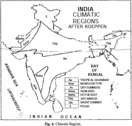
Ans. India has primarily a tropical monsoon type of climate. Due to its vast size and extent many regional variations of climate are found. On the basis of these, many regional patterns or sub-types of climate can be recognised. India has been divided into many climatic divisions. Each division has a broad uniformity of temperature and precipitation. Koeppen’s scheme of climatic classification. A German meteorologist, Wladimir Koeppen has divided the world into different climatic divisions. His method is based on mean monthly values of temperature and precipitation. Koeppen has identified five major climatic types. Capital letters have been used as symbols to show these such as A, B, C, D and E. The five types have been further sub-divided into sub-types. Small alphabets are used to show these subtypes.
Based on Koeppen's method, India can be divided into the following climatic regions : A = Tropical climate B = Dry climate C = Warm climate D = Cold climate E = Snow or Polar climate
(1) Monsoon type with short dry-season : (Amw). This type of climate prevails over western coast of India, South of Goa. The summers are wet and there is a short dry winter season.
(2) Monsoon type with dry summers : (As). This type of climate prevails over Coromandel coast (Tamilnadu). It has dry summers and wet winters.
(3) Tropical Savannah type : (Aw). This type of climate is found in Peninsular plateau. It has dry winters.

(4) Semi arid steppe climate (Bshw). This type of climate is found in desert areas of Rajasthan and Haryana.
(5) Hot desert type (Bwhw). This type of climate is found in the Extreme Western Rajasthan (Thar Desert).
(6) Monsoons type with dry winters (Cwg.). This type of climate is found in Northern plains of India. Most of rain falls in summer.
(7) Cold humid winter type with shorter summer (Dfc). This type of climate prevails overNorth East part of India. It has cold and wet winters with shorter summers.
(8) Polar climatic (E). This type of climate is found in Kashmir and adjoining mountain ranges.
Q. 6. Give an account of distribution of annual rainfall in India. How is it related to the relief of the country?
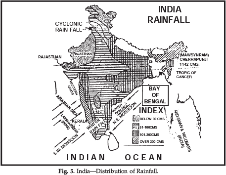
Ans. The average annual rainfall of India is 110 cms. Regional variations in the distribution are found due to differences in relief of the country. Rainfall is unevenly distributed throughout the country. India can be divided into the following rainfall regions:
(1) Areas of Heavy Rainfall. These areas get more than 200 cms. of annual rainfall. These include Western Coast and Western Ghats, Sub-Himalayas and the N.E. parts of India.
(2) Areas of Moderate Rainfall. These areas get annual rainfall of 100-200 cms. These include West Bengal, Odisha, Eastern parts of Uttar Pradesh and Madhya Pradesh, coastal plains of Tamilnadu.
(3) Areas of Low Rainfall. These areas experience an annual rainfall of 50-100 cms. These include western part of Uttar Pradesh Haryana, Punjab, Gujarat, Peninsular plateau and Eastern Rajasthan.
(4) Areas of Scanty Rainfall. These areas get less than 50 cms. of annual rainfall. These include Ladakh, S.W. Punjab, Southern Haryana, Western Rajasthan, Kutchh and Thar Desert.
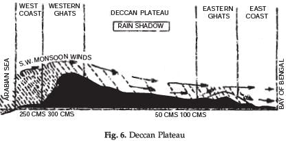
Effect to Relief on Rainfall. Orographic features play an important part in the distribution of rainfall in India. The amount of rainfall in an area is determined by the situation of the mountains. On the whole, it may be called relief rainfall in India. In mountain areas of Khasi-Jaintia hills the annual rainfall exceeds 1000 cms. In Ganga Valley, the amount of rainfall goes on decreasing. The on-shore winds give heavy rainfall on windward slopes : but rain shadow areas remain dry. Garo-Khasi hills get more than 1000 cms. of annual rainfall, but the amount drops to 200 cms. over Shillong plateau and Brahmputra Valley lying in the rain shadow. Malabar coast and Western Ghats get more than 300 cms. of rainfall, but Deccan plateau lies in the rain shadow of Western Ghats and remains dry (60 cms, rainfall). In Rajasthan, the Aravalli system lies parallel to the direction of the South West monsoons and is unable to force these winds to rise. So Rajasthan remains practically dry.
Q. 7. ‘‘In India most of the rainfall is of relief type.’’ Discuss.
Ans. Orographic features play an important part in the distribution of rainfall in India. The amount of rainfall in an area is determined by the location of the mountains. On the whole it may be called relief rainfall in India.
(i) In the mountainous areas of Khasi and Jaintia hills annual rainfall exceeds 1000 cm.
(ii) In the Ganga valley, the amount of rainfall goes on decreasing from east to west.
(iii) The onshore winds cause heavy rainfall on the windward slopes; but the rain shadow areas remain dry. Garo and Khasi hills get more than 1000 cm of annual rainfall, but the amount drops to 200 cm over Shillong Plateau and Brahmaputra Valley lying in the rain shadow region. The Malabar Coast and the Western Ghats get mroe than 300 cm of rainfall, but the Deccan Plateau lies in the rain shadow of the Western Ghats and remains dry (60 cm rainfall). In Rajasthan, the Aravalli system lies parallel to the direction of the S.W. monsoons and is unable to force these winds shed their moisture. So Rajasthan remains practically dry.
Q. 8. India would have been an arid land or desert, if there has been no phenomena of Monsoons’ Explain it giving four points.
Ans. Monsoons are the rain giver in India. India’s climate, (temperature and Rain fall) depend entirely on Monsoons. India would have been arid like west Asia, had there been no Monsoons. The winds would have become dry till these reached the western parts (like Rajasthan). Without Monsoons, there would not have been any dense forests in India. It would have the desert vegetation like bushes and shrubs because the prevailing winds would have arose from land which remained dry. Monsoons are wet as they pick up moisture from the Indian Ocean.
Q. 9. Why are Monsoons considered as a unifying bond in India?
Ans. There is a great diversity in climatic conditions of India due to differences in the relief features. But due to monsoon winds India has primarily a monsoon type of climate throughout the country. The whole country is influenced by the same order of seasons.
The Monsoonal rhythm of seasons is a great unifying force in India as :
(i) Monsoons control the atmospheric conditions of the country. Throughout the country, the summers are wet and the winters are dry due to the onshore winds. The distribution of rainfall is seasonal.
|
70 videos|347 docs|53 tests
|
FAQs on Long Question Answers: Climate - Geography Class 11 - Humanities/Arts
| 1. What is climate humanities/arts? |  |
| 2. How can climate humanities/arts contribute to addressing climate change? |  |
| 3. What are some examples of climate humanities/arts projects? |  |
| 4. How can individuals engage with climate humanities/arts? |  |
| 5. What are the potential benefits of integrating climate humanities/arts into climate change mitigation and adaptation strategies? |  |


