Indian Geography: Size & Location- 1 | Geography for UPSC CSE PDF Download

Size and Location
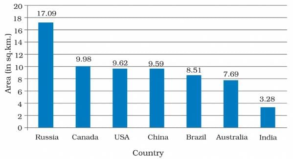
India with an area of 3,287,263 sq. km, is the seventh-largest country after Russia, Canada, USA, China, Brazil and Australia in that order and the second most populous (next to China) country in the world. It extends between 8°4' and 37°6' north latitudes and 68°7' and 97°25' east longitudes, lying north of the equator and thus belongs to Northern Hemisphere.
The Tropic of Cancer (23°30' N) divides the country into almost two equal halves. While the southern half coinciding with peninsular India lies in the tropical zone, the northern half, somewhat continental in nature, belongs to the subtropical zone. Situated to the east of the Prime Meridian, India also belongs to the Eastern Hemisphere.
- The country is of vast size. The north-south extension of India covers about 30°of latitude or measures about 3,214 km and the east-west extension covers almost 30° of longitude or measures about 2,933 km which is one-twelfth of the Earth’s circumference at the Equator.
- India has a land frontier of about 15,200 km. The total length of the coastline is approximately 7,516.6 km. India takes its standard time from the meridian of 82°30' E, which is 5 (1/2) hours ahead of Greenwich Mean Time (0° longitude). Pakistan time is 5 hours ahead of GMT and Bangladesh time is 6 hours ahead of GMT.
- The Indian subcontinent is a peninsula, more or less triangular in shape, which adjusts southward from the mainland of Asia. The lofty mountain ranges of the Himalayas in the north form the base of the triangle while the apex runs far out into the Indian Ocean in the south.
- It deserves to be called a subcontinent-meaning a large, relatively self-contained landmass forming a subdivision of a continent-both because of its large area and its large population.
- India occupies the southern part of the Asian continent, which is not only the largest but also the most populous continent in the world. Such a location has its own geopolitical and economic advantages.
- In ancient times its location helped in establishing cultural and other contacts with the Arab world in the west and south-east Asia and the Far East in the east.
Significance of Location
The country is isolated in a remarkable way from the rest of Asia, making it a distinct geographical unit. Barring the plateau of Baluchistan (which forms part of Pakistan), the two great ranges of Sulaiman and Kirthar cut it off from the west. Along the north, the great mountain wall formed by the Hindukush, Karakoram and the Himalayas, which is difficult to cross, cuts it off from the east of the continent.
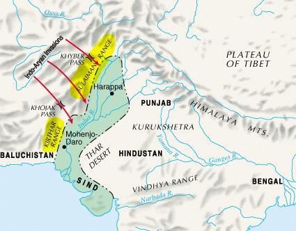 Sulaiman and Kirthar Range
- Similarly, the southward offshoots of the Eastern Himalayas separate it from Russia. The mountain barriers thus secure the country from the rest of Asia.
- In the west, the Indian Ocean in the south and the Bay of Bengal in the east. These again perform the security function besides providing a very good infrastructural component for the development of not only a transport system but also a defence system. The tropical monsoon climate of India, which ensures a fair supply of moisture and forms the basis of farming in India, is also a result of its location in the southern part of Asia.
- India’s strategic location at the head of the Indian Ocean from where entire Asia could be controlled had encouraged the British to make it the base of the British empire in the east. India is favourably situated on the world’s highway to trade and commerce both to east and west.
- The oceanic routes serving East and South-east Asia and Australia in the east and the countries of West Asia and Africa in the west pass through both the routes—the Cape of Good Hope and Suez Canal. Since the opening of the Suez Canal (1867) India’s distance from Europe has been reduced by 7000 Km. It thus bridges the space between the highly industrialized nation of the west and the semi-arid, and south-western Asia and the most fertile and populated regions in the south-east and far-east countries.
- The lack of islands in the Indian Ocean and the absence of any other country having such a large coastline this ocean as ours, with natural resources and population comparable to that of India, makes India even today, by far the most significant among the countries bordering the Indian Ocean.
|
264 videos|875 docs|232 tests
|
FAQs on Indian Geography: Size & Location- 1 - Geography for UPSC CSE
| 1. What is the size of India in terms of land area? |  |
| 2. Where is India located geographically? | |
| 3. Why is India's location significant? | |
| 4. How does India's size influence its climate and topography? | |
| 5. What are the implications of India's size and location on its economy? | |


Objective type Questions
,Important questions
,Indian Geography: Size & Location- 1 | Geography for UPSC CSE
,Viva Questions
,video lectures
,Summary
,shortcuts and tricks
,Indian Geography: Size & Location- 1 | Geography for UPSC CSE
,Indian Geography: Size & Location- 1 | Geography for UPSC CSE
,practice quizzes
,Semester Notes
,Sample Paper
,mock tests for examination
,Free
,Previous Year Questions with Solutions
,Extra Questions
,past year papers
,Exam
,MCQs
,ppt
,study material
;


Indian Geography: Size & Location- 1 Free PDF Download
Importance of Indian Geography: Size & Location- 1
Indian Geography: Size & Location- 1 Notes
Indian Geography: Size & Location- 1 UPSC Questions
Study Indian Geography: Size & Location- 1 on the App
|
© EduRev
|
Education Revolution
|


|


