Indian Climate - Weather Mechanisms | Geography for UPSC CSE PDF Download

WEATHER MECHANISMS
The variations in local climates of India arise due to a number of factors including :
(i) Surface distribution of pressure and winds,
(ii) Upper air circulation caused by factors controlling global weather and the inflow of different air masses and jet streams and
(iii) Inflow of western disturbances during the winter months and the tropical depressions during the South-West monsoon period into India creating weather phenomena conditions for rainfall.
 Pressure and surface windsThese mechanisms can be described with reference to the two main seasons of the year i.e, winter and summer when striking changes in weather occur.
- The distribution pattern of pressure in Central and West Asia generally influences the weather conditions of India during the winter months. A high pressure centre in the region lying to the north of the Himalaya gives rise to the flow of air at the low level from the north towards the Indian subcontinent. It is the dry continental air which is experienced in the north-western part of the Indian Plain during the winter months.
- The weather maps for this part of the year show a zone of contact between the north westerly continental air and the Indian trades lying over north-western India. The position of this contact zone is not, however, stable. Occasionally, it may shift its position as far east as the middle Ganga valley with the result that the whole of the north & western India up to the middle Ganga valley comes under the influence of dry north-western winds.
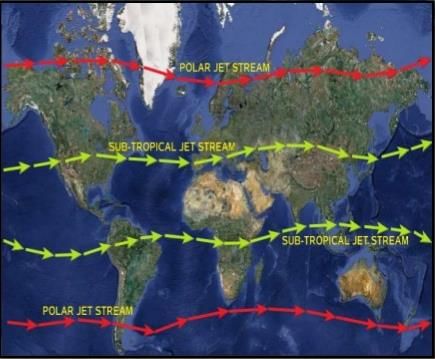
- This pattern of air circulation is observed only at the lower level of the atmosphere near the surface of the earth. Higher up in the lower troposphere, about three kilometres above the surface of the earth, different sure variations have no role to play in its making. The whole of West and Central Asia remains under the influence of westerly winds at this latitude. They blow with a steady velocity across the Asian continent at latitudes north of the Himalaya roughly parallel to the Tibetan highlands which act as a barrier in their path thus bifurcating the westerly wind, known as the jet stream.
 Jet stream affecting Indian climate
- One branch of the bifurcated jet stream flows to the north of this barrier. A southern branch of the jet stream flows in an eastward direction south of the Himalaya. It has its mean position at 250 N in February at 200 to 300 millibar level.
- According to the weather scientist, the southern branch of the jet stream has an important influence on the winter weather in India. The western disturbances which enter the Indian subcontinent from the west and the north-west during the winter months are brought into India by the westerly jet. These disturbances normally occur to the east of the aperture generally indicates in advance, the arrival of these disturbances.
- As the summer sets in and the sun shift northwards the wind circulation over the sub-continent undergoes a complete reversal at both the levels, lower as well as the upper. Near the surface, the Low Pressure Belt, which may be termed as Inter-Tropical Convergence Zone (ITCZ) forms an important zone of contact over northern India and Pakistan roughly parallel to the Himalaya.
- By the middle of July this zone of low pressure lies over India at about 250N. By this time the westerly jet stream withdraws from the Indian region.
- The ITCZ, being a zone of low pressure, invites inflow of winds from different directions. The maritime tropical air (MT) from the southern hemisphere, after crossing the Equator, rushes to the low pressure area in a general south-westerly direction. It is this moist air current which is popularly known as the south-west monsoon.
- Some scholars are of the opinion that the south-west monsoon, in fact, is a continuation of the equatorial westerlies which are flowing into the northern latitudes under the influence of the ITCZ. An easterly current of the tropical maritime air converges on the ITCZ along its north-eastern margins. The north-western margin, on the other hand becomes a zone of convergence subsidence for the dry continental air from the north-west.
The above pattern of the pressure and winds is found only at the lower level. The circulation pattern at the level of the troposphere is altogether different from this. An easterly jet stream, which prevails over the North Indian Plain during the winter months, the easterly jet stream steers the tropical depression over India. These depressions play a very significant role in the distribution pattern of the monsoon rainfall in the sub-continent. The highest rainfall occurs along the track of these depressions. The frequency at which these depressions visit India, their direction and intensity, all go a long way in determining the rainfall patterns during the south-west monsoon period.
Onset of Monsoons
The onset of south-west monsoon is a highly complex phenomenon and there is no single theory which can explain it fully. It is still believed that the differential heating and cooling of land and sea during the summer months causes the drift of monsoon winds towards the subcontinent. Since the pressure in the ocean to the south of the landmass is high due to lower temperature, the low pressure area attracts the south-east trades across the Equator. These conditions are favourable for a northward shift in the position of the ITCZ (Inter-Tropical Convergence Zone). The south-west monsoon, which reach the west coast of the south-east trades deflected towards the Indian sub-continent after crossing the Equator.
 Monsoon in India
- The shift in the position of the ITCZ is also related to the phenomenon of the withdrawal of the westerly jet stream from its position to the south of the Himalaya.
- The easterly jet stream sets in only after it has withdrawn itself from the region. The nature of this relationship can be understood with the help of a theory, according to which the easterly jet stream owes its origin to the summer heating of the Himalayan and the Tibetan highlands.
- With the northward shift in the position of the sun, these highlands are excessively heated. The radiation from this elevated landmass gives rise to a clockwise circulation in the middle troposphere.
- The two mainstream of air flowing out of this landmass take opposite directions. One of them flows towards the Equator probably to replace the air that crosses the Equator at the surface level, while the other is deflected towards the Pole.
- The Equatorward flow from these highlands prevails over India as the easterly jet stream, while the poleward outflow prevails over East-Central Asia as the westerly jet stream.
- It may be noted that the westerly jet stream continues to flow over Central Asia even during the summer months. Thus we see that the Himalayan and the Tibetan highlands play an important role in the development of the south-west monsoon.
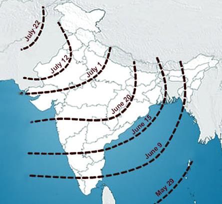
- The south-west monsoon engulfs the entire subcontinent by 15 July. It sets in over the Kerala coast by 1 June and moves swiftly to reach Bombay and Calcutta between 10-13 June.
Rain-Bearing System
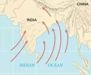
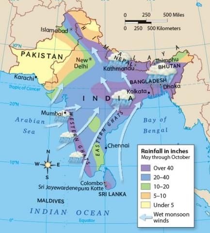
The projecting Indian peninsula divides the southwest monsoon into two branches, namely the Arabian Sea branch and the Bay of Bengal branch. The tropical depressions originating in the Bay of Bengal cause rainfall over the West Bengal and the adjoining states, the sub-Himalayan region and the Northern Plains. On the other hand, the Arabian Sea current brings rain to the west coast of India including Kerala, Karnataka, Maharashtra, Gujarat and Madhya Pradesh. The Arabian sea branch is more powerful as it is larger sea than the Bay of Bengal and moreover entire Arabian branch goes to India whereas only a part of Bay of Bengal current enters India, the remainder going to Burma, Malaysia and Thailand. With the sole exception of the east coast of Tamilnadu, every part of India receives its bulk of the annual rainfall from southwest monsoons.
Distribution of Rainfall - Annual rainfall of over 300 cm is received over parts of western coast and north-eastern India. Annual rainfall of less than 50 cm is experienced in western Rajasthan and adjoining parts of Gujarat, Haryana and Punjab.
- Rainfall is equally low in the interior of the Deccan plateau, east of the Sahyadris.
- The third area of low precipitation in the region around Leh in Kashmir. Rest of the country receives moderate rainfall. Snowfall is restricted to the Himalayan region.
- Distribution of rainfall received from south-west monsoons is very largely governed by the relief or orography. In simple words when moisture laiden air is forced to ascend the slopes of mountain range or the edge of a plateau the ascending air cools down and gets saturated and further ascent leads to heavy rainfall on windward slopes. Whereas on leeward slopes air descends and gets warmed up, shedding less and less rain. Hence on the leeward side of the mountain lies the rainshadow region which receives very low rainfall. For example the windward side of the western Ghats register a rainfall of over 250 cm.
- On the other hand, the leeward side of these Ghats is hardly able to receive 50cm. Again the heavy rainfall in the north-eastern states can be attributed to their hilly ranges and the Eastern Himalayas. The rainfall in the northern plains goes on decreasing from east to west. The rainfall during monsoon declines with increasing distance from the sea. Calcutta receives about 120cm, Patna 102 cm, Allahabad 91 cm and Delhi 56 cm.
- The monsoon rain is never continuous. It comes in spells. The wet spells are followed by dry spells. This pulsating nature of the monsoon is attributed to the cyclonic depression mainly formed at the head of the Bay of Bengal., and their crossing into the mainland. Besides the frequency and intensity of these depressions, the passage followed by them determines the intensity as well as distribution of rainfall. The passage is always along the axis of the "monsoon trough of the low pressure."
- For various reasons, the trough and its axis keep on moving northward or southward. For a fair amount of rainfall in the Northern Plains it is necessary that for the most part the axis of the monsoon trough should lie in the plains. On the other hand, whenever the axis shifts close to the Himalayas there are longer dry spells in the plains, and widespread rains in the mountainous catchment areas of the Himalayan rivers. These heavy rains bring in their wake devastating floods causing great damage to life and property.
Important Features and Significance of Monsoon Rains in India - The climatic factor that affects the economy of India the most, is the monsoon rain. The amount of rainfall strongly determines the cropping pattern. Nearly 80 percent of agriculture in India is dependent on monsoon rains and a substantial part of the irrigation water which supplies moisture to the remaining comes from stored supplies of rainwater in reservoirs.
- Animal husbandry is also dependent on the supply of adequate rainfall. Indian agriculture is, therefore, rightly, referred to as a gamble in the monsoon.
- Besides agriculture, hydroelectricity generation, which accounts for nearly two-fifths of total power generation in India, is also chiefly dependent on rainfall.
Uncertainty, high variability from normal dates of onset and withdrawals, great fluctuation in monthly and seasonal rainfall, erratic in nature and unequal distribution are some of the peculiar features of monsoon rains in India. - Both excessively high and low amounts of rainfall result in floods and droughts respectively which are so common in India that the country spends more to combat these calamities than on any other development.
- It should be noted that it is not the actual amount of the deficiency or excessiveness in the total amount of rainfall or the interval between the two rainfall but the period during which it occurs, is important. Even moderate deficiencies or excessiveness in the total rainfall can be disastrous during the critical periods of crop growth.
Seasons in India
The monsoon type of climate is characterised by distinct seasonality as it reveals a high degree of diversity in the distribution pattern of the elements of weather, particularly temperature and rainfall.
As per Indian Meteorological Department, Throughout most of the country, the year can be divided into four distinct seasons :
(i) hot-dry season (mid-March to May end)
(ii) hot-wet or south-west monsoon season (June to September)
(iii) retreating southwest monsoon season (October to November), and (iv) cold dry season (December to February)
(i) Hot-Dry Season
There is a progressive rise in temperature from 260C in mid-March to as high as 450C in mid-May, particularly in the Northern Plains whereas in the peninsular region there is a continuous decrease in temperature. The hot air over the Northern Plains, particularly over the north-western part, forms a low pressure centre.
 Wind direction in the summer season
The hot-dry season is characterised by weak wind and dryness over most of the country with some exceptions, such as tornado like dust storms of Punjab and Haryana, the andhis of Uttar Pradesh and the kalbaisakhis (Norwesters) of West Bengal cause some precipitation. Hot dry westerly winds called loos, blowing more frequently during May and June in the afternoons in the north-western parts of the country, desiccate plants and dry up surface moisture. They also render outdoor life difficult often resulting into several casualties. Low rain fall during the proceeding monsoons make the drought situation severe during the succeeding season as acute scarcity of water, food and fodder renders life miserable.
(ii) Hot-Wet Season
- This is the season of general rainfall. In early June, the south-westerly winds from the Indian Ocean begin to blow towards the low pressure centre of north-west India, which is at its lowest in July.
- These are southwest monsoons which bring rains rather suddenly, lowering the temperature substantially. This sudden onset of rain is often termed as monsoon burst, which generally occurs in the first week of June or even earlier in the coastal areas, while in the interior it may be delayed to the first week of July.
- With the onset of rains, temperature starts falling although June is extremely hot at most places in northern India. A second maxima is recorded in September when mean maximum temperature over most of northern India remains quite high.
 Wind direction in the rainy season
- The Indian subcontinent receives bulk of its rainfall during the south-west monsoon period.
- The south-west monsoon enters India in the form of two branches, viz, the Arabian sea branch and the Bay of Bengal branch.
- Except the Eastern of Coromandel coast of India, particularly in Tamilnadu, almost every part of India receives rainfall from these monsoons. The eastern or Tamilnadu coast remains relatively dry because it lies in the rainshadow area of the Arabian Sea current and is parallel to the Bay of Bengal current.
- The Arabian Sea branch advances northwards by 1st June on the Kerala coast and reaches Bombay by about 10 June. On the way, it is obstructed by the Western Ghats. The windward side of the Sahyadris receive very heavy rains.
- Crossing the Ghats they overrun the Deccan plateau and Madhya Pradesh causing fair amount of rainfall. Thereafter they enter the Ganga plains and mingle with the Bay of Bengal branch.
- Another part of the Arabian Sea branch strikes the Saurashtra peninsula and the Kutch. It then passes over west Rajasthan and along the Aravallis, causing only a scanty rainfall.
- In Punjab and Haryana, it too joins the Bay of Bengal branch. These two branches, reinforced by each other cause rains in the Western Himalayas.
- The Bay of Bengal branch first strike the Burmese coast and part of the south-east Bangladesh. But the Arakan Hills along the Burmese coast deflect a big chunk of this branch towards the Indian sub-continent.
- The monsoon, therefore, enter west Bengal and Bangladesh from south and south-east instead of the south westerly direction. Thereafter this branch splits into two under the influence of the mighty Himalayas and the thermal low in north-western India.
- One branch moves westward along the Ganga plains reaching as far as the Punjab plains. The other branch moves up the Brahmaputra valley in the north and north-east causing widespread rains in North-eastern India.
- Its sub-branch strikes the Garo and Khasi Hills of Meghalaya. It is on the southern face of other hills that Cherrapunji and Mawsynaram are situated at the head of a funnel-shaped valley. Their unique topographical location together with perpendicular wind direction is responsible for causing here the heaviest rainfall in the world.
- Cherrapunji receives 1,087 cm and Mawsynram 1,141 cm. Withdrawal of monsoon is a more gradual process than its onset. By mid-September the south-west monsoon starts retreating as due to the southward migration of the sun, the high pressure begins to develop over the land and consequently, low pressure area moves southwards.
- The monsoon retreats earlier in the north where September has hot and sticky weather with a distinct rise in temperature which, however, comes down by the end to October giving way to cool weather. The fine weather conditions extend towards eastwards and southwards.
- At the beginning of October, a low pressure area is centred over northern parts of Bay of Bengal and by the beginning of November it moves further south.
- The rainy season is, therefore, at this time limited to the east coast of Tamilnadu and south of the Peninsula, where the rainiest period is between October and November.
- By the beginning of December, the low pressure area moves further south, and by its end, it passes out of Bay limits into the equatorial belt.
- A similar pattern is followed in the Arabian Sea. In northern India, clear autumn weather, which sets in with the retreat of the monsoon persists till the third/fourth week of December.
(iii) Cold Dry Season
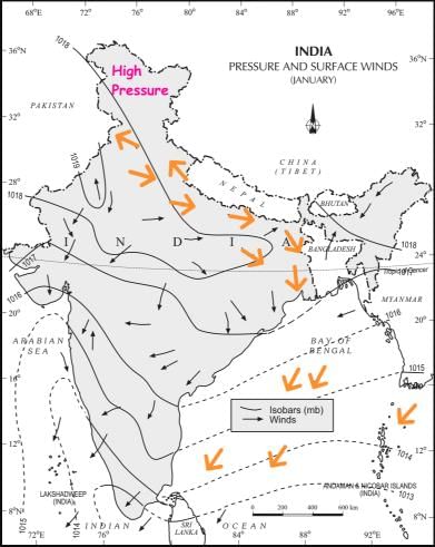
In India, the cold weather season starts with December and ends by February. Temperatures during the coldest month (January) may vary from 10-150C in the Nothern plain to 250C in the southern part of the Peninsula. Cold winter conditions lead to the formation of high pressure in the Northern plains. Winds blow out from this high pressure towards the low pressure in the equatorial region, that is they blow from the land to the sea over most part of the country and hence the dry season. These winds are north-westerly or northeasterly in the Ganga plains and become north-easterly over the Bay of Bengal. Most parts of India have fine weather with clear skies, low temperatures and humidity, cool breeze and rainless days.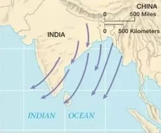 Wind direction in the winter season
The fine weather conditions, however, at intervals get disturbed by shallow cyclonic depressions, also known as western disturbances, which originate over the east Mediterranean and Pakistan before bringing light rainfall in the plains and snowfall on the mountains.
The only part of India benefiting from the north-east trade winds is the coast of Tamilnadu which gets most of its rainfall from these winds that absorb moisture content while blowing over the Bay of Bengal. It is in this context these winds are popularly called as north-east monsoons.
|
264 videos|875 docs|232 tests
|
FAQs on Indian Climate - Weather Mechanisms - Geography for UPSC CSE
| 1. What is the average temperature in India? |  |
| 2. What are the major seasons in India? | |
| 3. How does the monsoon impact India's climate? | |
| 4. Are there any regional variations in India's climate? | |
| 5. How does climate change affect India? | |


Sample Paper
,past year papers
,Semester Notes
,Free
,Indian Climate - Weather Mechanisms | Geography for UPSC CSE
,study material
,mock tests for examination
,Previous Year Questions with Solutions
,Important questions
,shortcuts and tricks
,Extra Questions
,Summary
,Indian Climate - Weather Mechanisms | Geography for UPSC CSE
,Objective type Questions
,practice quizzes
,Viva Questions
,Indian Climate - Weather Mechanisms | Geography for UPSC CSE
,Exam
,MCQs
,video lectures
,ppt
;


Indian Climate - Weather Mechanisms Free PDF Download
Importance of Indian Climate - Weather Mechanisms
Indian Climate - Weather Mechanisms Notes
Indian Climate - Weather Mechanisms UPSC Questions
Study Indian Climate - Weather Mechanisms on the App
|
© EduRev
|
Education Revolution
|


|


within 7 days!