Class 6 Geography Chapter 4 Question Answers - Maps

Q1: Why are conventional symbols used in maps?
The signs and symbols use in a map are called as Conventional symbols.
Conventional symbols are widely accepted signs or sign systems which signify an idea or concept. They represent different features on a map and are not drawn to scale. They are important because: Symbols can be used to depict features like cities, roads and railways.
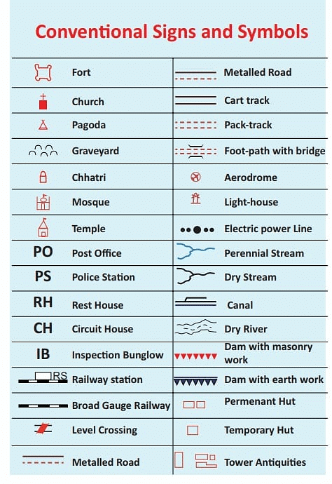 Conventional Symbols
Q2: What do you understand by the scale of the map?
The scale is the relation between distance on the map and the corresponding distance on the ground, e.g. if the distance on the map and grounds of same two points is 1 cm and 1km receptively, the scale of the map will be 1cm to 1km, R.F= (1:1000000). Scale is very important in any map. If you know the scale, you will be able to calculate the distance between any two places on a map.
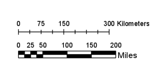 Image of Map Scale
Q3: List the three main components of a map.
- Distance: From one place or object to other in defined measurements.
- Direction (Orientation): Indicates cardinal directions (north, south, east, west) to help users navigate on the map.
- Symbol: Graphical representations used to convey information about features or objects on the map, such as landmarks, roads, and rivers.
Q4: List the ways in which the globes are more useful than maps.
Globes are preferred more useful than maps because of the reasons given below:
- It shows the poles, latitudes, longitudes, oceans and continents in their correct shape.
- There are globes which show various relief features like mountains, plateaus and plains.
- It also shows distance between the two adjoining meridians which decreases as one goes away from the equator towards the poles.
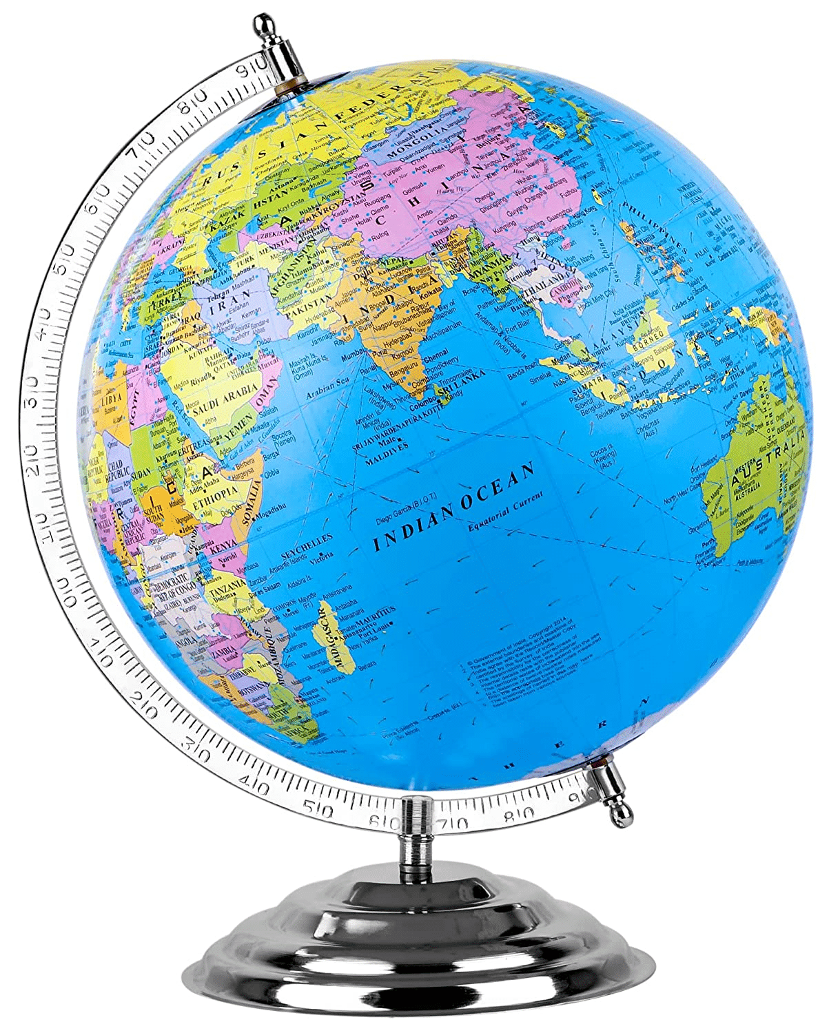 Globe
Globe
Q5: Write short notes on a compass.
A compass is a very simple instrument used to find out the direction of a place. It has a magnetic needle, which rotates freely in a horizontal place and is balanced on a fine point. The magnetic needle always points toward north-south direction.
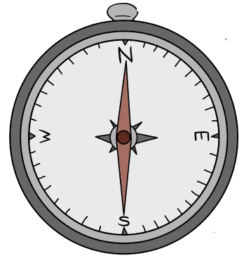 Compass
Q6: Explain the advantages of using maps?
- Maps can show more details.
- Many maps when put together make an atlas and show various continents, countries and can provide information about any particular aspect.
- Maps can be drawn in small scale as well as in large scale.
- Maps can be folded / rolled and are easily portable.
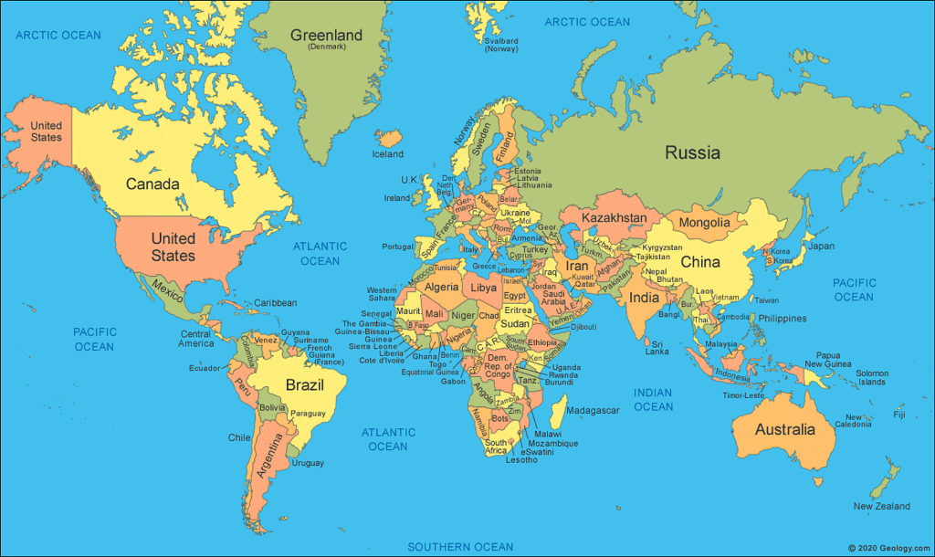 World Map
Q7: Explain the Thematic maps.
Some maps may focus on specific information of the regions, for example rainfall maps, road maps, tourist map and topographical maps. Such maps represent a particular topic or theme and are called thematic maps.
Q8: Why political maps use more number of colours as compared to physical map?
Political maps use more colors than physical maps because they show things created by people, like borders and countries. This makes them colorful and helps us understand where different places are. On the other hand, physical maps focus on nature and use simpler colors to show mountains, rivers, and landforms.
Q9: Write about the shortcomings of a globe?
- A globe cannot show as many details as a map can.
It does not give details of any country and details like districts, states, town or villages.
It is also heavy and difficult to carry around.
Q10: What is the easiest way to remember compass directions?
The earth rotates west to east, so the sun rises in the east and sets in the west. No matter which side one is facing, east is the morning sun and west is the evening sun or night time.
Long Questions & Answers
Q.1. Differentiate between a Physical Map and Political Map.
Physical Map:
Physical Map of India
- Focus: Physical maps highlight the natural features of the Earth's surface.
- Features: They show geographical features such as mountains, rivers, valleys, deserts, lakes, and other physical characteristics.
- Terrain: Physical maps give you an idea of the landscape and the physical attributes of a region.
- Colors: Different colors are often used to represent various elevations or types of landforms. For example, green might represent lowland areas, while brown might indicate mountains.
- Useful for: Understanding the physical layout of a place, exploring natural features, and learning about the Earth's topography.
Political Map:
Political Map of India
- Focus: Political maps emphasize human-made boundaries and divisions.
- Features: They show countries, states, cities, and other man-made structures such as roads and political borders.
- Labels: Political maps use labels to identify and name political entities like countries, capitals, and cities.
- Colors: Colors are used to distinguish between different countries or regions and to highlight political boundaries.
- Useful for: Understanding political organization, identifying countries and cities, and learning about the administrative divisions of a region.
In summary, physical maps showcase the natural aspects of the Earth's surface, while political maps focus on human-made divisions and structures.
Q.2. Differentiate between a map and a plan.
Map
- A map is like a picture or drawing of the Earth's surface or a part of it, but it's flattened out to fit on paper.
- Maps show a lot of details about large areas on the Earth.
- When the picture on paper is not too big, we call it a map, especially when we want to show a whole region.
- Maps are great for looking at big places, like a map of an entire region.
- If we want to know about how high or low places are, we use lines on a special kind of map called a topographic map.
Plan
- A plan is a drawing of a small area, usually not too big.
- Plans give us information about specific local areas, but they don't show as much detail as maps.
- When we want to see something on, under, or behind the Earth's surface in a small area, we use a plan.
- Plans are useful for looking at things like houses, bridges, or schools, where we need to see more details about a smaller space.
- On a plan, we find out about how far things are from each other and in what direction they are located.
Q3: What is the difference between the magnetic North Pole and geographical North Pole?
Geographical North Pole:
- The Geographic North Pole is where lines of longitudes converge into what we call the North Pole.
- A compass does not always points to the Geographic North Pole.
- The Earth`s geographic north pole remains fixed.
- Geographic north and south poles are determined by the earth's spin.
Magnetic and Geographic North Poles
Magnetic North Pole:
- The Magnetic Pole is a point in Northern Canada where the northern lines of attraction enter the Earth.
- A compass needle will point to the direction of the Magnetic North Pole.
- The Earth’s magnetic north is changing every day because of the hot, liquid metal that surrounds the inner core.
- Magnetic north is determined by the direction a compass points
Q4: How can you measure distance on the map?
When you want to know how far places are from each other on a map, you can follow these simple steps:
- Look for the Scale: Find the scale on the map. It might be like a ruler or have words or numbers. For example, if it says "1 centimeter equals 10 kilometers," that's important.
- Use a Ruler: Take a ruler and measure the distance between the two places on the map. If the path is not straight, you can use a string to follow the path and then measure the string. Let's say you measured 3 centimeters on the map.
- Calculate the Real Distance: If the scale is like "1 centimeter equals one kilometer," you can figure out the real distance. Using our example, since 1 centimeter on the map is 10 kilometers in reality, you can find the real distance by multiplying the measured distance on the map by the scale. So, 3 centimeters on the map means 30 kilometers in real life.
Therefore, according to the specified scale, the true distance between the two locations is 30 kilometers.
Q5: Mention some of the disadvantages of a magnetic compass.
- Equator Stability: Near the equator, the compass works well, but as you go closer to the Magnetic Pole, it becomes less reliable.
- Drifting Near Magnetic Pole: Close to the Magnetic Pole, the compass doesn't show a specific direction and starts drifting randomly.
- Needle Pointing Up or Down: When approaching the poles, the compass needle may start pointing up or down because of something called magnetic inclination.
- Risk with Cheap Compasses: Inexpensive compasses with poor quality may get stuck due to these magnetic changes, leading them to show the wrong direction.
Q6: What do the following colors represent on the map?
Blue, Red, Yellow, Green, Brown and Black
- Blue - lakes, rivers, streams, oceans, reservoirs, etc.
- Red - major highways, roads, urban areas, airports, special interest sites, military sites, place names, buildings, borders.
- Yellow - built-up or urban areas.
- Green - parks, golf courses, forest, orchards, highways.
- Brown - deserts, historical sites, national parks, military reservations or bases, contour (elevation) lines. Black - railroads, highways, bridges, place names, buildings, borders.
Q7: What are the basic characteristics of a good map?
Maps are the basic tools of geography that enable us to depict spatial phenomenon on paper. A good map will have:
1. Legend: A good map will have a legend or key which shows the user what different symbols mean. For instance, a square with a flag on top usually represents a school and roads are represented by a variety of widths and combinations of lines.
2. Direction: Without a north arrow, it is difficult to determine the orientation of a map. With a north arrow (pointing in the correct direction), a user can determine direction.
3. Title: A map's title provides important clues about the cartographer's intentions and goals.
FAQs on Class 6 Geography Chapter 4 Question Answers - Maps
| 1. What are the different types of maps and their purposes? |  |
| 2. How do maps help in understanding geography? | |
| 3. What is the significance of scale in map reading? | |
| 4. How can technology enhance map-making and usage? | |
| 5. What skills are important for effective map interpretation? | |


Sample Paper
,Class 6 Geography Chapter 4 Question Answers - Maps
,Class 6 Geography Chapter 4 Question Answers - Maps
,Important questions
,video lectures
,Class 6 Geography Chapter 4 Question Answers - Maps
,past year papers
,Summary
,MCQs
,Previous Year Questions with Solutions
,Viva Questions
,shortcuts and tricks
,mock tests for examination
,ppt
,practice quizzes
,Free
,Extra Questions
,Exam
,Semester Notes
,Objective type Questions
,study material
;


Short & Long Question Answers: Maps Free PDF Download
Importance of Short & Long Question Answers: Maps
Short & Long Question Answers: Maps Notes
Short & Long Question Answers: Maps Class 6 Questions
Study Short & Long Question Answers: Maps on the App
|
© EduRev
|
Education Revolution
|


|


