Best Study Material for Humanities/Arts Exam
Humanities/Arts Exam > Humanities/Arts Notes > Class 12 Geography Solved Paper (2016 Delhi Set-I)
Class 12 Geography Solved Paper (2016 Delhi Set-I) - Humanities/Arts PDF Download
Ques 1: Why is the age structure considered an important indicator of population composition? Give one reason.
Ans: Age structure represents the number of people of different age groups. This is an important indicator of population composition, since a large size of population in the age group of 15-59 indicates a large working population. A greater proportion of population above 60 years represents an ageing population which requires more expenditure on health care facilities. Similarly high proportion of young population would mean that the region has a high birth rate and the population is youthful.
Ques 2: 'Leading a long and healthy life is an important aspect of human development.' Give an argument to support the statement.
Ans: Living a long and healthy life indicates access to resources, health facilities and improved levels of nutrition intake. Hence it is an important aspect of human development.
Ques 3: 'Agri-business farms are mechanized and large in size.' Examine the statement.
Ans: This type of farming is mainly found in the case of Extensive Commercial Grain farming where Wheat is the principal crop, though other crops like corn, barley, oats and rye are also grown. The size of the farm is very large and the entire process of cultivation from ploughing to harvesting are mechanised.
Ques 4: Examine the functioning of World Trade Organisation (WTO).
Ans: The WTO is the only international organization dealing with the global rules of trade between nations. It sets the rules for the global trading system and resolves disputes between its member nations. WTO also covers trade in services, such as telecommunication and banking, and others issues such as intellectual rights.
Ques 5: Name the state of India with highest literacy rate as per 2011 census.
Ans: Kerala.
Ques 6: Which major sea port on the eastern coast of India has a land locked harbour?
Ans: Chennai.
Ques 7: Name the state of India with largest area.
Ans: Rajasthan.
Ques 8: 'The nature and human beings are so intricately intertwined that they can't be separated.' Substantiate the statement.
Ans: Man and Environment share a reciprocal relationship. In the early stages Human activities were controlled and governed by Environment. Man acted as a Passive agent. This is so because the level of technology was very low and the stage of human social development was also primitive. This type of interaction between primitive human society and strong forces of nature was termed as environmental determinism. However, with the passage of time people began to understand their environment and the forces of nature. With social and cultural development, humans develop better and more efficient technology and are able to create possibilities with the resources obtained from the environment.
The human activities create cultural landscape. This concept is known as Possibilism which states that Nature provides opportunities and human beings make use of these and slowly nature gets humanised and starts bearing the imprints of human endeavour. However the reckless use of resources have already resulted in Global warming, Ozone depletion and pollution of the environment. Thus the resources available in the Nature have to be used judiciously so that it does not degrade the environmental quality and may result in sustainable development.
Ques 9: Study the diagram given below and answer the questions that follow: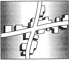 (i) Identify and name the given rural settlement pattern.
(ii) In which type of areas do we find such type of settlement patterns?
(iii) Give an important characteristic of this type of settlement pattern.
Ans: (i) Cross shape rural settlement pattern.
(ii) It is mostly found in areas of new development where the settlements spread out along the major roads.
(iii) These settlements develop on the cross-roads and houses extend in all the four direction.
Ques 10: Study the following diagram and answer the questions that follow: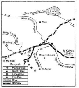 (i) Identify and name the steel plant shown in this diagram.
(ii) Name the mining fields which supply coal and limestone to this plant.
(iii) Mention the source of water for this plant.
Ans: (i) Jamshedpur steel plant.
(ii) Coal is brought from Joda mines in Orissa, Jharia and Bokaro coal fields Coking coal comes from Jharia and west Bokaro coal fields.
(iii) Rivers Subarnarekha and Kharkai provide water to the plant.
Ques 11: 'The promotion of the use of non-conventional sources of energy in India is the need of the hour.' Support the statement.
Ans: The use of fossil fuels like coal and petroleum results m environmental problems. Hence the use of alternative source of energy has become more important in India for the following reasons:
1. The alternative sources of energy like solar energy, wind energy etc. are renewable. Hence they are sustainable and will never run out.
2. The renewable resources being derived from natural and available resources reduces the cost of operation.
3. These alternative energy resources produce little or no harmful pollutants like carbon dioxide etc. and are thus more environment friendly.
Ques 12: 'Many of the modern towns in India were developed during the period of British domination.' Substantiate the statement.
Ans: The British and other Europeans have developed a number of towns in India. They first developed some trading ports such as Mumbai, Chennai, and Kolkata. Surat, Daman, Goa, Pondicherry, etc. for the ease of trade and commerce. Gradually they established their administrative centres, hill towns, summer resorts etc. Towns based on modern industries also evolved after 1850, e.g. Jamshedpur. After independence, a large number of towns have been developed as administrative headquarters, e.g. Chandigarh, Bhubaneswar, Gandhinagar, Dispur, etc. and industrial centres such as Durgapur; Bhilai, Sindri, Barauni etc. Some old towns also developed as satellite towns around metropolitan cities such as Ghaziabad, Rohtak, and Gurgaon around Delhi. With increasing investment in rural areas, a large number of medium and small towns have developed all over the country.
Ques 13: 'The urban waste should be properly treated as a resource for various needs of mankind.' Explain the values that can help in changing the urban waste into resources.
Ans: The value that can help in changing the urban waste into resources are:
1. Creating awareness: Societies should be made aware for using the urban waste in the productive use for example - kitchen and garden waste can be converted into compost. Sewage can be used to produce biogas.
2. To evolve the new techniques: Innovative production techniques should be used such as waste exchanges process in which the waste product of one process becomes the raw material for a next process. Waste exchanges process will help to use waste which is difficult to eliminate for example in the manufacturing of soap glycerin will be extracted from the waste.
3. Caring attitude towards urban waste: The urban waste should be treated with care as Scraps can be re-used at the beginning of the manufacturing process so that they do not become a waste product for example, paper mills use the damaged rolls to the beginning of the production line, the metal and plastic items, can be re-incorporated into new products.
Ques 14: What is 'demographic cycle'? Describe three stages of 'demographic transition theory.?
Ans: Demographic transition theory can be used to describe and predict the future population of any area. The theory tells us that population of any region changes from high births and high deaths to low births and low deaths as society progresses from rural agrarian and illiterate to urban industrial and literate society. These changes occur in stages which are collectively known as the demographic cycle.
The first stage has high fertility and high mortality because people reproduce more to compensate for the deaths due to epidemics and variable food supply. The population growth is slow and most of the people are engaged in agriculture where large families are an asset. Life expectancy is low, people are mostly illiterate and have low levels of technology. The population remains stationary. Two hundred years ago all the countries of the world were in this stage.
Fertility remains high in the beginning of second stage but it declines with time. This is accompanied by reduced, mortality rate. Improvements in sanitation and health conditions lead to decline in mortality. Because of this gap the net addition to population is high.
So the population expands. Thus this stage is also known as the Expending stage.
In the last stage, both fertility and mortality decline considerably. The population is either stable or grows slowly. The population becomes urbanised, literate and has high technical knowhow and deliberately controls the family size.
Ques 15: Differentiate between Nomadic herding and commercial livestock rearing, stating any five points of distinction.
Ans: Nomadic Herding
(i) Practiced by nomads who lead a migratory life.
(ii) They wander from place to place in search or pasture and water.
(iii) Quality of the animals is poor and so is the produce which meets the local requirement of the nomads.
(iv) Practiced generally in tropical grassland Savannahs and the pastures are not permanent.
(v) A wide variety of animals is kept in different regions. In tropical Africa, cattle are the most important livestock, while in Sahara and Asiatic deserts, sheep, goats and camel are reared. In the mountainous areas of Tibet and Andes, yak and llamas and in the Arctic and sub-Arctic areas, reindeer are the most important animals.
Commercial Herding
(i) Practiced by people who are well settled.
(ii) Animals are reared on big ranches, sheep stations. The animals are well cared.
(iii) Quality of animals is very good, the produce from the animals is large and the products are processed and exported.
(iv) Practiced in the temperate grasslands - Pampas, Prairies Downs and the rearing of the cattle and sheep is done systematically on a large scale.
(v) This is a specialised activity in which only one type of animal is reared. Important animals include sheep, cattle, goats and horses. Products such as meat, wool, hides and skin are processed and packed scientifically and exported to different world markets.
Ques 16: What is 'tourism'? Analyse any four tourist attractions in the world.
Ans: Tourism is travel undertaken for purposes of recreation rather than business. Tourism is developed in areas having suitable climate, picturesque landscape or are important religious, cultural or centre of History and art.
There are various tourist attractions all over the world and they are important for their own unique features:
1. Warm, sunny weather for beach holidays. This is one of the main reasons for the importance of tourism in South - ern Europe and the Mediterranean lands.
2. Places like the Himalayas in India the Alps in Europe are known for their natural beauty and attract tourists from all over the World for various adventure sports and mountain climbing.
3. Places like Mecca, Kashi, Jerusalem are important tourist attractions as they have a rich heritage and every year tourists visit these places for pilgrimage.
Goa, Maldives etc. are famous for their luxuriant sea beaches.
Ques 17: 'The Suez and the Panama canals are two vital man - made navigation canals which serve as gateways of commerce for both the eastern and western worlds.' In the light of this statement explain the economic significance of these two canals.
Ans: This canal had been constructed in Egypt between Port Said in the North and Port Suez in the South linking the Mediterranean Sea and the Red Sea. Suez Canal decreases the road between Europe and South Asia from 16000 km (travel from the Cape of Good Hope) to 10000 km.
Suez Canal helps especially to developed countries to trade with developing ones. Most of developing countries are placed in Middle East and Asia. Therefore, developed European countries open up factories in borders of those who have cheap labour force and land. Moreover finished products could be easily transported from ports in South Asia to Europe or United States.
This Canal strengthens the power of Egypt in world economy. With the taxes from the ships which use the Suez Canal, Egyptian economy keeps growing day-by-day. The required labour force comes from Egypt and reduces the unemployment rate in the country.
Suez Canal gives Egypt a strategic power to affect world trade by having a transportation road between developing and developed countries.
The Panama Canal connects the Atlantic Ocean in the East to the Pacific Ocean in the West.
It shortens the distance between New York and San Francisco by 13,000 km by sea. The canal permits shippers of commercial goods, ranging from automobiles to grain, to save time and money by transporting cargo more quickly. Prior to the completion of the canal, a ship sailing between ports in New York and San Francisco had to sail around Cape Horn, which took 67 days.
Ques 18: Explain why the causes of male and female migration are different in India. Find out the environmental consequences of migration.
Ans: The reasons tor migration, of males and females are different. For example, work and employment is the main cause for male migration while it is very less tor the females Contrary to this, about 65 per cent of females move our from their parental houses following their marriage. This is the most important cause in the rural areas of India except in Meghalaya where reverse is the case.
Overcrowding of people due to rural-urban migration has put pressure on the existing social and physical infrastructure in the urban areas. Tins ultimately leads to unplanned growth of urban settlement and formation of slums shanty colonies. Apart from tills, due to over-exploitation of natural resources, cities are facing the acute problem of depletion of ground water, air pollution, and disposal of sewage and management of solid wastes.
Ques 19: 'Erratic monsoon' and 'Indebtedness' are the major problems of Indian agriculture.? Suggest and explain the measures to overcome these problems.
Ans: Agriculture in India is affected by uncertain, unreliable and erratic monsoon rainfall. India cannot achieve sustained progress in agriculture unless and until more than half of the cropped area is brought under assured irrigation. Expansion of irrigation has played a very crucial role in enhancing agricultural output in the country. It provided basis for introduction of modern agricultural technology such as high yielding varieties of seeds, chemical fertilizers, pesticides and farm machinery. The net irrigated area in the country has increased from 20.85 to 54.66 million ha over the period 1950 -51 to 2000-01. Over these 50 years, area irrigated more than once in an agricultural year has increased from 1.71 to 20.46 million ha.
The main suppliers of money to the farmer are the money-lenders, traders and commission agents who charge high rate of interest and purchase the agricultural produce at very low price. The inputs of modern agriculture are very expensive and are often out of reach of the marginal and small farmers as they have very meagre or no saving to invest in agriculture, All India Rural Credit Survey Committee showed that in 1950-51 the share of money lenders stood at as Ugh as 68.6 per cent of the total rural credit and in 1975-76 their share declined to 43 per cent of the credit needs of the farmers. This shows that the money lender is losing ground but is still the single largest contributor of agricultural credit. Rural credit scenario has undergone a significant change and institutional agencies such as Central Cooperative Banks, State Cooperative Banks, Commercial Banks, Cooperative Credit Agencies and some Government Agencies are extending loans to farmers on easy terms. There has been a steady increase m the flow of institutional credit to agriculture over the years.
Ques 20: Why is the distribution of roads not uniform in India? Explain, with examples.
Ans: The factors for me uneven distribution of roads in India are:
Nature of terrain: Mountains, plateaus and plains. Construction of roads is easy and cheaper in me level plain areas, while it is difficult and costly in hilly and plateaus areas. The distribution of roads is not uniform in the country. Density of roads varies from only 10.48 km in Jammu and Kashmir to 387.24 km in Kerala with a national average of 75.42 km. The density of road is high in most of the northern states and major southern states. It is low in the Himalayan region, north-eastern region, Madhya Pradesh and Rajasthan. Construction of roads is easy and cheaper in the plain areas while it is difficult and costly in hilly and plateau areas.
Density of population: Density of? population affects the demand of roads. Urban settlements having high population usually have high density of road network while remote rural areas usually lack such facilities, e.g. Kolkata.
The levels of economic development: Developed areas have high demand of roads also have money for construction and maintenance, e.g. Gujarat.
Industrial areas: Important industrial regions have high density of road networks that help in the transport of raw materials and finished products, e.g. Jamshedpur.
Centres of trade and commerce and commercial towns have high density of road networks to facilitate connectivity to markets, ports and collection centres, e.g. Mumbai.
Ques 21: Five Geographical features shown on the given political outline map of the world as A, B, C, D and E. Identify these features with the help of the information given below and write their correct names on the lines marked near them: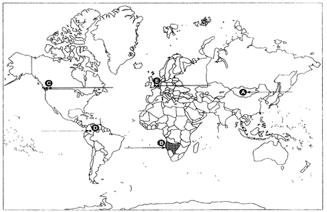 (A) The country with lowest density of population in Asia.
(B) An area of nomadic herding.
(C) A major sea port
(D) An international airport
(E) A mega city
Ans: 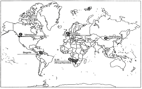
Ques 22: Locate and label the following on the given political outline map of India with appropriate symbols.
(i) The state having the highest density of population (2011).
(ii) The state with smallest rural population.
(iii) Mayurbhanj - an iron ore mining area.
(iv) An oil refinery in Karnataka state.
(v) The headquarter of South Central Railway Zone.
Ans: 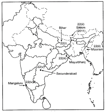
The document Class 12 Geography Solved Paper (2016 Delhi Set-I) - Humanities/Arts is a part of Humanities/Arts category.
All you need of Humanities/Arts at this link: Humanities/Arts

FAQs on Class 12 Geography Solved Paper (2016 Delhi Set-I) - Humanities/Arts
| 1. What are the major topics covered in the Class 12 Geography Solved Paper (2016 Delhi Set-I) exam? |  |
| 2. How can I prepare effectively for the Class 12 Geography exam? | |
Ans. To prepare effectively for the Class 12 Geography exam, you can start by thoroughly studying the prescribed textbook and syllabus. It is important to understand the concepts, theories, and terminologies related to geography. Additionally, practicing previous year's question papers and sample papers can help you familiarize yourself with the exam pattern and improve your time management skills.
| 3. What is the significance of solving the Class 12 Geography Solved Paper (2016 Delhi Set-I)? | |
Ans. Solving the Class 12 Geography Solved Paper (2016 Delhi Set-I) provides several benefits. It helps in understanding the exam pattern, marking scheme, and types of questions asked in the actual exam. By solving the paper, you can assess your preparation level, identify your strengths and weaknesses, and work on improving them. It also helps in building confidence and reducing exam stress.
| 4. Are there any important tips or strategies to keep in mind while attempting the Class 12 Geography exam? | |
Ans. Yes, there are a few important tips and strategies to keep in mind while attempting the Class 12 Geography exam. Firstly, read the question carefully and understand what is being asked. Plan your answers before writing them and ensure a logical and structured flow of information. Use diagrams, maps, and examples wherever appropriate to enhance your answers. Practice time management to complete the exam within the given duration. Lastly, revise your answers and make sure to answer all questions.
| 5. Where can I find more Class 12 Geography Solved Papers for practice? | |
Ans. You can find more Class 12 Geography Solved Papers for practice from various sources. Some options include online educational platforms, bookstores that specialize in academic materials, or even your school or coaching institute's library. Additionally, several websites offer downloadable PDFs of solved papers that you can easily access and print for practice.
Related Exams
About this Document

4.77/5
Rating

Apr 10, 2025
Last updated
Document Description: Class 12 Geography Solved Paper (2016 Delhi Set-I) for Humanities/Arts 2025 is part of Humanities/Arts preparation. The notes and questions for Class 12 Geography Solved Paper (2016 Delhi Set-I) have been prepared according to the Humanities/Arts exam syllabus. Information about Class 12 Geography Solved Paper (2016 Delhi Set-I) covers topics like and Class 12 Geography Solved Paper (2016 Delhi Set-I) Example, for Humanities/Arts 2025 Exam. Find important definitions, questions, notes, meanings, examples, exercises and tests below for Class 12 Geography Solved Paper (2016 Delhi Set-I).
Introduction of Class 12 Geography Solved Paper (2016 Delhi Set-I) in English is available as part of
our Humanities/Arts preparation & Class 12 Geography Solved Paper (2016 Delhi Set-I) in Hindi for Humanities/Arts
courses. Download more important topics, notes, lectures and mock test series for Humanities/Arts
Exam by signing up for free. Humanities/Arts: Class 12 Geography Solved Paper (2016 Delhi Set-I) - Humanities/Arts
Description
Full syllabus notes, lecture & questions for Class 12 Geography Solved Paper (2016 Delhi Set-I) - Humanities/Arts - Humanities/Arts | Plus excerises question with solution to help you revise complete syllabus | Best notes, free PDF download
Information about Class 12 Geography Solved Paper (2016 Delhi Set-I)
In this doc you can find the meaning of Class 12 Geography Solved Paper (2016 Delhi Set-I) defined & explained in the simplest way possible.
Besides explaining types of Class 12 Geography Solved Paper (2016 Delhi Set-I) theory,
EduRev gives you an ample number of questions to practice Class 12 Geography Solved Paper (2016 Delhi Set-I) tests, examples and also practice Humanities/Arts tests.
Download as PDF

Related Searches
Semester Notes
,mock tests for examination
,Free
,Summary
,Class 12 Geography Solved Paper (2016 Delhi Set-I) - Humanities/Arts
,past year papers
,Viva Questions
,video lectures
,MCQs
,Sample Paper
,Class 12 Geography Solved Paper (2016 Delhi Set-I) - Humanities/Arts
,study material
,Class 12 Geography Solved Paper (2016 Delhi Set-I) - Humanities/Arts
,Objective type Questions
,shortcuts and tricks
,Previous Year Questions with Solutions
,ppt
,Important questions
,Exam
,practice quizzes
,Extra Questions
;


Additional Information about Class 12 Geography Solved Paper (2016 Delhi Set-I) for Humanities/Arts Preparation
Class 12 Geography Solved Paper (2016 Delhi Set-I) Free PDF Download
The Class 12 Geography Solved Paper (2016 Delhi Set-I) is an invaluable resource that delves deep into the core of the Humanities/Arts exam.
These study notes are curated by experts and cover all the essential topics and concepts, making your preparation more efficient and effective.
With the help of these notes, you can grasp complex subjects quickly, revise important points easily,
and reinforce your understanding of key concepts. The study notes are presented in a concise and easy-to-understand manner,
allowing you to optimize your learning process. Whether you're looking for best-recommended books, sample papers, study material,
or toppers' notes, this PDF has got you covered. Download the Class 12 Geography Solved Paper (2016 Delhi Set-I) now and kickstart your journey towards success in the Humanities/Arts exam.
Importance of Class 12 Geography Solved Paper (2016 Delhi Set-I)
The importance of Class 12 Geography Solved Paper (2016 Delhi Set-I) cannot be overstated, especially for Humanities/Arts aspirants.
This document holds the key to success in the Humanities/Arts exam.
It offers a detailed understanding of the concept, providing invaluable insights into the topic.
By knowing the concepts well in advance, students can plan their preparation effectively.
Utilize this indispensable guide for a well-rounded preparation and achieve your desired results.
Class 12 Geography Solved Paper (2016 Delhi Set-I) Notes
Class 12 Geography Solved Paper (2016 Delhi Set-I) Notes offer in-depth insights into the specific topic to help you master it with ease.
This comprehensive document covers all aspects related to Class 12 Geography Solved Paper (2016 Delhi Set-I).
It includes detailed information about the exam syllabus, recommended books, and study materials for a well-rounded preparation.
Practice papers and question papers enable you to assess your progress effectively.
Additionally, the paper analysis provides valuable tips for tackling the exam strategically.
Access to Toppers' notes gives you an edge in understanding complex concepts.
Whether you're a beginner or aiming for advanced proficiency, Class 12 Geography Solved Paper (2016 Delhi Set-I) Notes on EduRev are your ultimate resource for success.
Class 12 Geography Solved Paper (2016 Delhi Set-I) Humanities/Arts Questions
The "Class 12 Geography Solved Paper (2016 Delhi Set-I) Humanities/Arts Questions" guide is a valuable resource for all aspiring students preparing for the
Humanities/Arts exam. It focuses on providing a wide range of practice questions to help students gauge
their understanding of the exam topics. These questions cover the entire syllabus, ensuring comprehensive preparation.
The guide includes previous years' question papers for students to familiarize themselves with the exam's format and difficulty level.
Additionally, it offers subject-specific question banks, allowing students to focus on weak areas and improve their performance.
Study Class 12 Geography Solved Paper (2016 Delhi Set-I) on the App
Students of Humanities/Arts can study Class 12 Geography Solved Paper (2016 Delhi Set-I) alongwith tests & analysis from the EduRev app,
which will help them while preparing for their exam. Apart from the Class 12 Geography Solved Paper (2016 Delhi Set-I),
students can also utilize the EduRev App for other study materials such as previous year question papers, syllabus, important questions, etc.
The EduRev App will make your learning easier as you can access it from anywhere you want.
The content of Class 12 Geography Solved Paper (2016 Delhi Set-I) is prepared as per the latest Humanities/Arts syllabus.
|
© EduRev
|
Education Revolution
|


|


Signup on EduRev and stay on top of your study goals
10M+ students crushing their study goals daily