Long Question Answers : Interior of the Earth

Q. 1. What are earthquake waves ? Describe their types and characteristics.
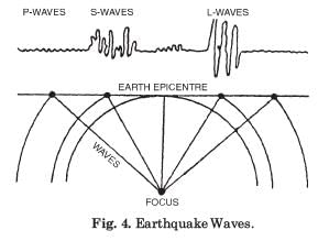
Ans. Earthquake waves provide the most reliable information regarding the structure of the earth. The vibrations recorded during an earthquake are called waves. An earthquake is the shaking of the earth caused by the release of energy along a fault. The point where the energy is released is called the focus or hypocentre. The point on the surface directly above the focus is called the epicentre. These waves are recorded by an instrument called a seismograph.
There are three types of earthquake waves:
- Body waves: These are generated at the focus and travel through the body of the earth in all directions. They are of two kinds. P-waves (primary waves) move faster and arrive first at the surface. They are similar to sound waves and travel through gaseous, liquid and solid materials. The particles vibrate parallel to the direction of the wave, creating density differences that lead to stretching and squeezing of the material. S-waves (secondary waves) arrive later. They can travel only through solid materials. The particles vibrate perpendicular to the direction of the wave in the vertical plane, creating troughs and crests.
- Surface waves: These are generated when body waves interact with surface rocks. They move along the surface and are the last to reach the seismograph. They are the most destructive waves and cause displacement of rocks and collapse of structures.
The velocity of these waves changes as they travel through materials of different densities. The denser the material, the higher the velocity. Their direction also changes when they reflect or refract at boundaries of different densities. The study of these waves reveals the layered interior of the earth. For every earthquake, there is a shadow zone where waves are not recorded. Between 105° and 145° from the epicentre, P-waves are absent in a band, while S-waves are absent beyond 105° from the epicentre, covering about 40 per cent of the earth's surface. The absence of S-waves in the core indicates that the outer core is in liquid state. These variations in wave behaviour confirm the presence of discontinuities and different layers inside the earth.
Q. 2. Describe the structure of Earth, giving details about each of its layers or shells and arguments in support of your answer.
Or
Discuss how do Seismic waves suggest layering of earth interior.
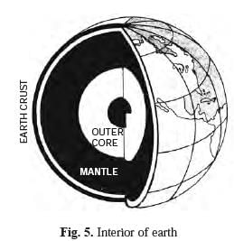
Ans. The structure of the earth consists of three main layers. These layers have been inferred mainly from the behaviour of earthquake waves and their velocities at different depths.
The outermost layer is the crust. It is the solid and brittle part of the earth. Its thickness varies greatly. Under the oceans it is thin, with a mean thickness of about 5 km. Under the continents it is thicker, with an average of around 30 km. In major mountain regions such as the Himalayas it reaches up to 70 km.
Below the crust lies the mantle. It extends from the Moho discontinuity to a depth of 2,900 km. The upper part of the mantle is known as the asthenosphere. It is a weak zone extending up to about 400 km and is the main source of magma that rises during volcanic eruptions. The crust together with the uppermost mantle forms the lithosphere, whose thickness ranges from 10 to 200 km. The lower mantle below the asthenosphere is in solid state.
The innermost layer is the core. The boundary between the mantle and the core lies at a depth of 2,900 km. The outer core is in liquid state while the inner core is in solid state. The core is made up of very heavy materials, mostly nickel and iron, and is sometimes referred to as the nife layer.
Seismic waves provide strong support for this layered structure. The sudden changes in the velocity and direction of P-waves and S-waves at certain depths indicate sharp boundaries or discontinuities. The complete absence of S-waves beyond 105° from the epicentre shows that the outer core is liquid, as S-waves cannot pass through liquids. The shadow zones of both P-waves and S-waves further confirm the existence of these layers. The increasing density and pressure with depth, as inferred from wave behaviour, also match the characteristics of crust, mantle and core.
Q. 3. What do you understand by intrusive forms? Briefly describe various intrusive forms.
Ans. Intrusive forms are the structures developed when the lava or magma cools and solidifies within the crustal portion instead of reaching the surface. The cooling may take place either on reaching the surface or while the lava is still inside the crust. Depending on the location of cooling, igneous rocks are divided into volcanic rocks (cooling at the surface) and plutonic rocks (cooling inside the crust). The forms that develop when lava cools inside the crust are called intrusive forms.
The major intrusive forms are as follows:
- Batholiths are large bodies of magmatic material that cool at greater depths in the crust and develop into big dome-shaped structures. They appear on the surface only after the denudational processes remove the overlying materials. They cover large areas and are granitic in composition. They represent the cooled portion of magma chambers.
- Lacoliths are large dome-shaped intrusive bodies with a level base and connected by a pipe-like conduit from below. They resemble the surface volcanic domes of composite volcanoes but are located at deeper depths. They can be regarded as the localised source of lava that finds its way to the surface. The domal hills of granite rocks in the Karnataka plateau are examples of lacoliths.
- Lapolith is a saucer-shaped body that develops when lava moves horizontally and takes a concave-to-the-sky form. Phacolith is a wavy mass of intrusive rocks found at the base of synclines or at the top of anticlines in folded igneous regions. It has a definite conduit to the magma chamber below.
- Sills or sheets are near-horizontal bodies of intrusive igneous rocks. The thinner ones are called sheets while the thick horizontal deposits are called sills.
- Dykes are wall-like structures formed when lava makes its way through cracks and fissures and solidifies almost perpendicular to the ground. These are the most commonly found intrusive forms in the western Maharashtra area and are considered the feeders for the eruptions that led to the development of the Deccan Traps.
Q. 4. Describe the volcanic activity and the major features associated with it.
Ans. A volcano is a place where gases, ashes and/or molten rock material called lava escape to the surface. The material below the crust in the mantle is in a weaker zone called the asthenosphere. The molten rock in the upper mantle is magma. When it reaches the surface it is called lava. The materials thrown out include lava flows, pyroclastic debris, volcanic bombs, ash, dust and gases such as nitrogen compounds, sulphur compounds and minor amounts of chlorine, hydrogen and argon.
Volcanoes are classified on the basis of the nature of eruption and the form developed at the surface.
The major types are:
- Shield volcanoes are the largest. They are made up of basalt lava which is very fluid. They are not steep and have low explosivity unless water enters the vent. The Hawaiian volcanoes are famous examples. The lava moves in the form of a fountain and sometimes develops cinder cones at the top of the vent.
- Composite volcanoes are formed by eruptions of cooler and more viscous lavas than basalt. They produce explosive eruptions along with large quantities of pyroclastic material and ash. Layers of these materials accumulate and give the volcanoes a composite appearance.
- Calderas are the most explosive volcanoes. They collapse on themselves after eruption because the magma chamber is huge and close to the surface. The collapsed depressions are called calderas.
Flood basalt provinces occur when highly fluid lava flows for long distances. Some parts of the world are covered by thousands of square kilometres of thick basalt flows. Individual flows may be more than 50 m thick and extend for hundreds of kilometres. The Deccan Traps in India covering most of the Maharashtra plateau are a major example of flood basalt province.
Mid-ocean ridge volcanoes occur in oceanic areas along a system of mid-ocean ridges more than 70,000 km long. The central portion of these ridges experiences frequent eruptions.
Volcanic landforms also include intrusive forms formed when lava cools within the crust. These are:
- Batholiths are large bodies of magmatic material that cool at great depths and form domes. They appear on the surface only after the overlying rocks are removed by denudation. They are granitic and cover large areas.
- Lacoliths are large dome-shaped bodies with a level base connected by a pipe-like conduit. They resemble surface volcanic domes but occur at deeper levels. The domal hills in the Karnataka plateau are examples.
- Lapolith is a saucer-shaped body concave to the sky. Phacolith is a wavy mass found at the base of synclines or top of anticlines in folded regions. Sills or sheets are near-horizontal bodies; thinner ones are sheets and thicker ones are sills. Dykes are wall-like structures formed when lava solidifies in cracks and fissures perpendicular to the ground. They are common in the western Maharashtra area and acted as feeders for the Deccan Traps eruptions.
FAQs on Long Question Answers : Interior of the Earth
| 1. What are the layers of the Earth's interior? |  |
| 2. How do scientists study the interior of the Earth? | |
| 3. What is the significance of understanding the Earth's interior? | |
| 4. How does the composition of the Earth's interior vary? | |
| 5. How does the temperature change in the Earth's interior? | |


