Geography of North America | Geography for UPSC CSE PDF Download

GEOGRAPHY OF NORTH AMERICA
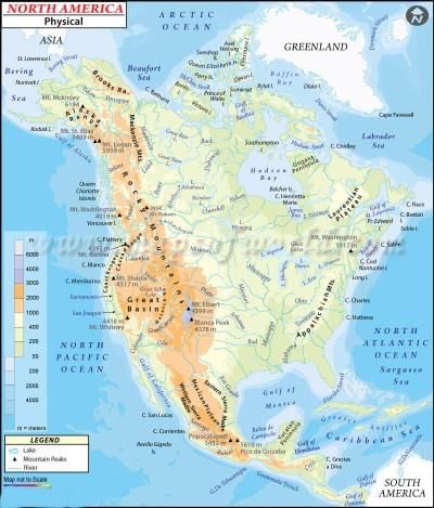
- North America is the third largest continent after Asia and Africa. It covers an area of nearly 24 million square kilometers.
- From south to north, it extends from 7°N to 85°N latitude and east to west from 20°W to 179° W.
- In other words, its northern boundary is only about 500 kilometers away from the North Pole and its western boundary only 10 kilometers away from the International Date Line.
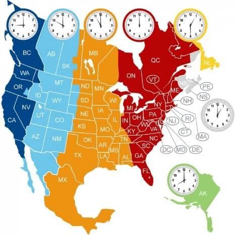
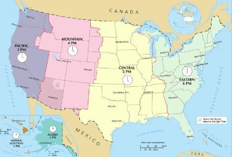
- There are five time zones in North America.
- The Tropic of Cancer and the Arctic Circle passes through the continent and the 100°W longitude cuts through the center of the continent.
 North-America-Time-zone
 US-Timezone
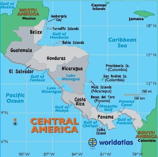
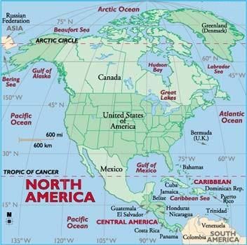
- This huge landmass includes three large countries – Canada, the United States of America and Mexico, seven small states of Central America, and the islands of the West Indies.
- The Atlantic, Pacific, and Arctic oceans surround North America in the east, west, and north respectively.
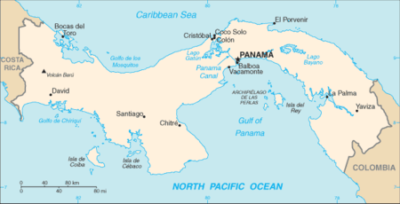
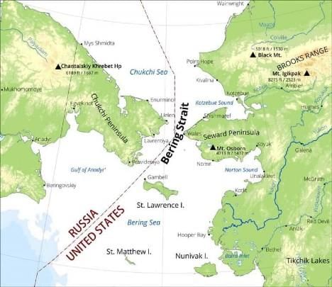
- In the north-west, the Bering Strait separates it from Asia and in the south-east, the Isthmus of Panama joins it to South America. North America has a smooth coastline except for the existing in the north-west.
Regional Divisions Of North America
Region-wise North America can be classified into the following parts which are listed below:
Western Region
- Great Plains
- Canadian Shield
- Eastern Region
Western Region
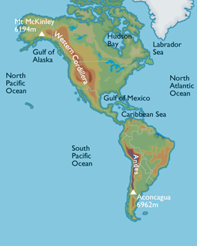
Young mountains rise in the west. The most familiar of these mountains are probably the Rockies, North America’s largest chain. They stretch from the province of British Columbia, Canada, to the U.S. state of New Mexico.
Great Plains
In the middle of the continent lies the Great Plain. Deep, rich soil blankets are large areas of the plains in Canada and the United States. Grain is grown in this region called the “Breadbasket of North America,” feeds a large part of the world. The Great Plains are also home to rich deposits of oil and natural gas.
Canadian Shield
The Canadian Shield is a raised but relatively flat plateau. It extends over eastern, central, and northwestern Canada. The Canadian Shield is characterized by a rocky landscape pocked by an astounding number of lakes.
Eastern Region
This varied region includes the Appalachian Mountains and the Atlantic coastal plain. North America’s older mountain ranges, including the Appalachians, rise near the east coast of the United States and Canada. These areas have been mined for rich deposits of coal and other minerals for hundreds of years.
Major Physical Divisions Of North America
- The Western Cordilleras
- The Central Lowlands
- The Eastern Highlands
The Western Cordilleras
- The parallel ranges of young fold mountains run from Alaska and extend into South America as the Andes.
- As they resemble twisted cords they are known as Cordilleras.
- Fold mountains are formed when tectonic plates push the Earth’s crust and force it to form ridges and valleys.
- Volcanic rocks from the base of fold mountains.
- The Cordilleras are part of the Pacific Ring of Fire. Mount St. Helena is in the USA.
- The snow-covered Cordilleras act as a barrier to moisture-laden winds and cause relief rainfall.
- Some of the rivers flow westwards and some eastwards with the Cordilleras acting as the water divide between them.
- Rocky Mountains, Alaska Range, Cascades, Sierra Nevada, and the Sierra Madre are the chief ranges of the Western Cordilleras
- The Grand Canyon is a network of deep narrow valley cuts into the dry Colorado Plateau.
- The Old Faithful” is a natural geyser (a hot waterspout). Once in every 90 minutes, the water from the geyser comes out roaring up to 60 meters high. It is found in Yellowstone National Park.
The Central Lowlands
- These stretch from around the Arctic Shores and Hudson Bay to the Gulf of Mexico.
- They are hemmed in by the Cordilleras in the west and the highlands in the east.
- In the west, they are known as high plains because of the greater altitudes.
- In the north, they form the Canadian Shield.
- The Canadian Shield is a peneplain with a number of lakes. They are large enough to be called seas. They are the five Great lakes – Superior, Michigan, Huron, Erie, and Ontario.
- Lake Winnipeg, Great Bear Lake, and Lake Athabaska are also on the Canadian Shield.
- South of the Canadian Shield, the Central Lowlands are covered with layers of sediment brought by glaciers and rivers. It is a very fertile region.
Great Lakes of USA –
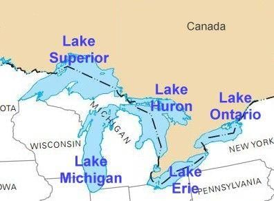
Importance of great lakes region
- Glacial lakes
- The largest freshwater system
- Together – they hold 1/5 th of the earth surface’s freshwater
- Source of drinking water, irrigation, transport, sulfide and iron mining in the periphery
The Eastern Highlands
- They are old fold mountains that stretch from the valley of River St. Lawrence to Southern USA.
- They are not high or as continuous as the Cordilleras.
- The highlands are also known as the Laurentian highlands in Canada and the Appalachians in the USA and are less than 2,000 meters in height.
- Their eastern slopes facing the Atlantic Ocean are very steep causing waterfalls in the streams that flow to the coast.
Canadian Shield
The Canadian Shield is a raised but relatively flat plateau. It extends over eastern, central, and northwestern Canada. The Canadian Shield is characterized by a rocky landscape pocked by an astounding number of lakes.
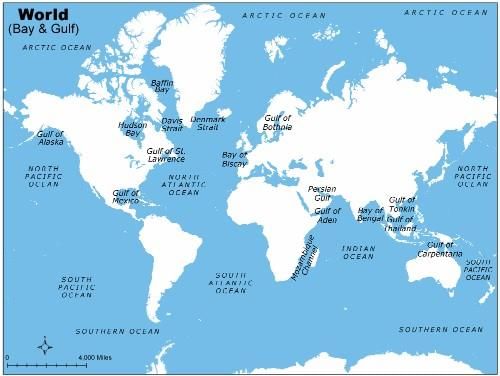
Gulfs Of North America
A gulf is a portion of the ocean that penetrates land which is very large in size, shape, and depth. They are generally larger and more deeply indented than bays and often make excellent harbors. Many important trading centers are located on gulfs.
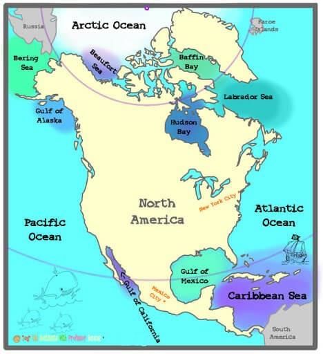
- Gulf of Mexico
- Gulf of Alaska
- Gulf of California
- Gulf of St. Lawrence
Gulf Of Mexico
It is an important economic site for three countries and surrounded by the United States, Mexico, and the island nation of Cuba. As one of the biggest gulf, it has a coastline of 5000 kilometers.
Gulf Of Alaska
It is situated in the northwestern part of North America where two types of water run into each other, a light, almost electric blue merging with a darker slate-blue.
Gulf Of California
It separates the Baja California Peninsula from the Mexican mainland. It has a coastline of 4000 km( 2600 miles). It is considered to be one of the most diversified seas on the planet and is home to more than 5,000 species of microinvertebrates.
Gulf Of St. Lawrence
It is a water outlet of the North American Great Lakes via Saint Lawrence river. It’s a semi-enclosed sea that covers 236,000 square kilometers (91,000 sq mi) and containing about 35,000 cubic kilometers (8,400 cu mi) of water, which results in an average depth of 148 meters (486 ft).
Islands
The world famous islands of North America are:
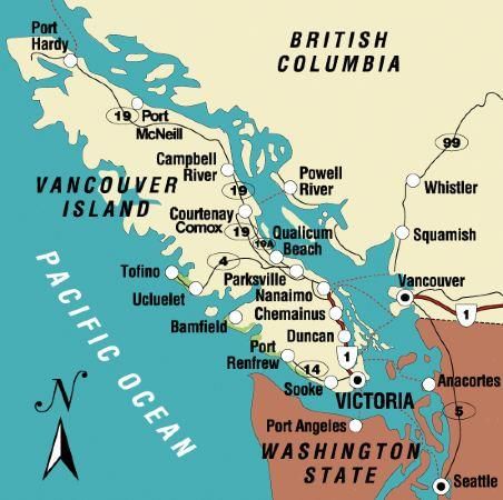
Vancouver Island
It is situated on Canada’s Pacific Coast, is known for its mild climate and thriving arts community. It is separated from British Columbia mainland by the Strait of Georgia and Queen Charlotte Strait and from Washington by the Juan De Fuca Strait.
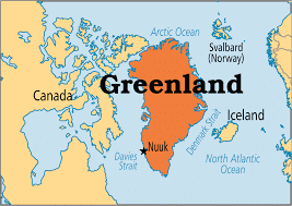
Greenland
It is a massive island situated between Atlantic and Arctic oceans and 80% of its land is covered by ice.
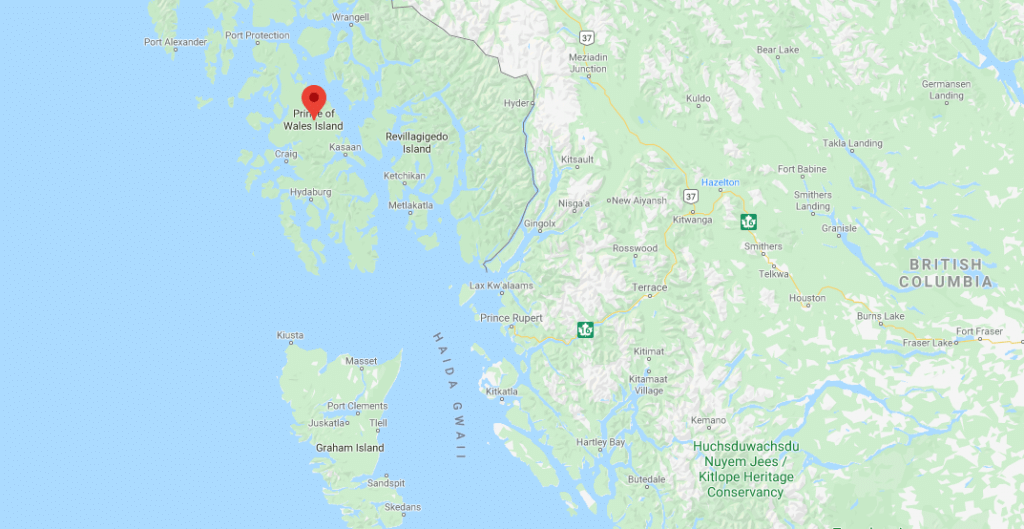
Prince Of Wales Island
It is one of the islands of the Alexander Archipelago in the Alaska Panhandle. This ranks four among the island in size.
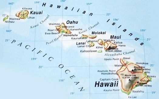
Hawaii Island
It is otherwise known as the Big Island provides a vast canvas of natural environment and it is the largest island of the Hawaiian archipelago in the Central Pacific.
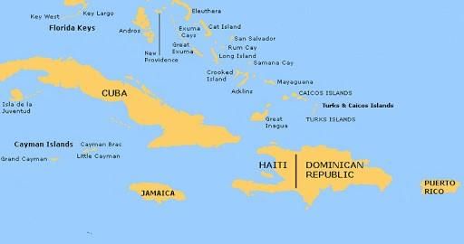
Cuba Islands Of Antilles
It is known as the sugar bowl of the World and its vast source of metallic resources include cobalt, nickel, iron ore, chromium, and copper. Other resources include timber, petroleum, silica, salt, and arable land.
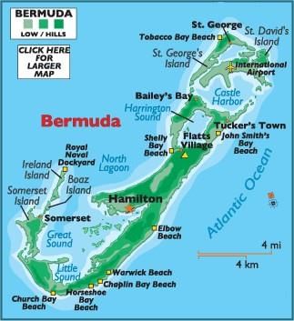
Bermuda Island
It is the territory of the British Islands in North Atlantic and famous for its pink sand beaches such as Elbow and Horseshoe Bay.
Drainage Pattern
There are many rivers in North America. River of North America can be grouped according to the seas they drain into, like
- Rivers draining into the Gulf of Mexico
- Rivers draining into the Atlantic Ocean
- Arctic Ocean drainage
- Pacific Ocean Drainage
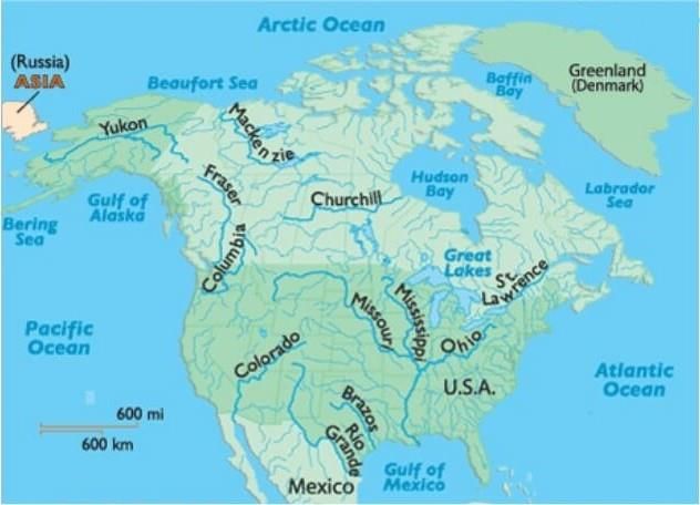
1. The Rivers Draining Into The Gulf Of Mexico
These are the Mississippi, Missouri and their tributaries drain the whole of the lower Central Lowlands. They start from the Western Cordilleras. The Ohino and Tennesse. Rivers which are also tributaries of the Mississippi but have their source in the Appalachians are exceptions.
2. Rivers draining into the Atlantic Ocean
River St. Lawrence is the large river of this group. In this group the smaller rivers of the Fall Line can also be included.
3. Arctic Ocean drainage
River Mackenzie which has many shallow lakes on the Canadian Shield. River Nelson flow into the Hudson Bay.
4. Pacific Ocean Drainage
River Yukon in Alaska, Columbia, Fraser, and Colorado along the west coast. The Colorado River cuts across the Colorado plateau and forms the world’s most famous and attractive deep gorges, known as grand canons having nearly one km depth. Among the other rivers, the Yukon, the Fraser, the Snake, the Humboldt, the Sacramento, the San Joaquin, etc. are well known.
Seas In North America
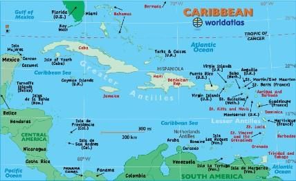
Caribbean Sea
It is a sub-oceanic basin bordered by coasts of Venezuela, Colombia, and Panama; to the west by Costa Rica, Nicaragua, Honduras, Guatemala, Belize, and the Yucatán Peninsula of Mexico; to the north
by the Greater Antilles islands of Cuba, Hispaniola, Jamaica, and Puerto Rico; and to the east by the north-south chain of the Lesser Antilles, consisting of the island arc that extends from the Virgin Islands in the northeast to Trinidad.
Beaufort Sea
It is situated in the north of Canada and Alaska is known to be the marginal sea of Arctic Ocean covering an area of 184,000 sq. miles and the average depth of 3,239 ft (1,004 m).
Hudson Bay
It is known as the second largest bay in the world which encompasses an area of 1,230,000 square kilometer (470,000mi) and large body of Salt water.
Labrador Sea
It is bordered by continental shelves and separates Canada from Green Land.
Bering Sea
It is situated on the extreme North of North America separating the continents of Asia and north America.
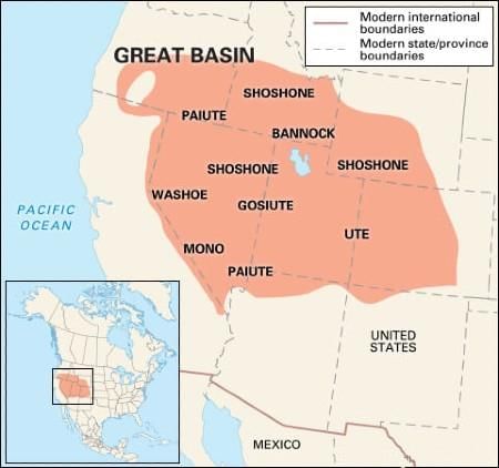
Inland Drainage System
The Great Basin area in the Rocky Mountains (Middle) has rivers which do not reach the coast, but terminate in the land. This is the Inland Drainage System.
The rivers are small, seasonal and end up in saline lakes.
Lakes In North America
- The Lakes of the Canadian Shield are freshwater bodies.
- The Great Salt Lake between the Rockies and the Sierra Nevada has a high salt content and is an area of ‘Inland drainage’.
- Lake Erie in Ontario, Canada, and Michigan, New York, Ohio, Pennsylvania in the USA.
- Lake Huron in Ontario, Canada, and Michigan in the USA.
- Lake Ontario in Ontario, and New York in the USA.
- Lake St Clair in Ontario, and Michigan in the USA.
- Lake Superior in Michigan, Minnesota, Wisconsin in the USA.

|
264 videos|875 docs|232 tests
|
FAQs on Geography of North America - Geography for UPSC CSE
| 1. What are the major physical features of North America? |  |
| 2. How many countries are located in North America? | |
| 3. What is the largest city in North America by population? | |
| 4. What are the main climate zones in North America? | |
| 5. How do the Rocky Mountains influence the geography of North America? | |


shortcuts and tricks
,Geography of North America | Geography for UPSC CSE
,practice quizzes
,Geography of North America | Geography for UPSC CSE
,Exam
,past year papers
,MCQs
,video lectures
,Free
,Extra Questions
,Geography of North America | Geography for UPSC CSE
,study material
,Previous Year Questions with Solutions
,mock tests for examination
,Summary
,Objective type Questions
,Viva Questions
,Semester Notes
,ppt
,Sample Paper
,Important questions
;


Geography of North America Free PDF Download
Importance of Geography of North America
Geography of North America Notes
Geography of North America UPSC Questions
Study Geography of North America on the App
|
© EduRev
|
Education Revolution
|


|


