UPSC Exam > UPSC Notes > Geography for UPSC CSE > Regional Division of Plains
Regional Division of Plains | Geography for UPSC CSE PDF Download

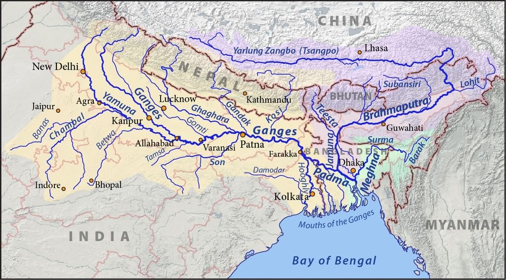
Regional Divisions of the Indo-Gangetic-Brahmaputra
Plains [Great Plains]
- Sindh Plain
- Rajasthan Plain.
- Punjab Plain.
- Ganga Plain.
- Brahmaputra Plain.
- Ganga – Brahmaputra Delta
Sindh Plain [Pakistan]
- It was mainly formed of Bhangar Plains.
- Dhors: Long narrow depressions which are the remnants of the course of former rivers.
- Dhand: Alkaline lakes on some dhors.
Rajasthan Plain
- Occupied by Thar or the Great Indian Desert.
- This plain is an undulating plain [wave like] whose average elevation is about 325 m above mean sea level.
- The desert region is called Marusthali and forms a more significant part of the Marwar plain.
- It has a few outcrops of gneisses, schists and granites which proves that geologically it is a part of the Peninsular Plateau. It is only at the surface that it looks like an aggradational plain.
- The eastern part of the Marusthali is rocky while its western part is covered by shifting dunes locally known as Dhrian.
- The eastern part of the Thar Desert up to the Aravali Range is a semi-arid plain known as Rajasthan Bagar.
- It is drained by several short seasonal streams originating from the Aravali and supports agriculture in some patches of fertile tracts.
- Luni is a crucial seasonal stream which flows into Rann of Kuchchh. The tract north of the Luni is known as thali or sandy plain.
Saline Lakes
- North of the Luni, there is inland drainage having several saline lakes. They are a source of common salt and many other salts.
- Sambhar, Didwana, Degana, Kuchaman, etc. are some of the important lakes. The largest is the Sambhar lake near Jaipur. Question for Regional Division of PlainsTry yourself:Dunes of western Marusthali plain is known locally asView Solution
Punjab Plain
- This plain was formed by five important rivers of the Indus system.
- The plain is primarily made up of ‘doabs’ —the land between two rivers.
- The depositional process by the rivers has united these doabs giving a homogenous appearance.
- Punjab means “The Land of Five Waters” referring to the following rivers: the Jhelum, Chenab, Ravi, Sutlej, and Beas.
- The total area of this plain is about 1.75 lakh sq km.
- The average elevation of the plain is about 250 m above mean sea level.
- The eastern boundary of Punjab Haryana plain is marked by subsurface Delhi-Aravali ridge.
- The northern part of this plain [Shiwalik hills] has been intensively eroded by numerous streams called Chos. This led to enormous gullying [Arid Landforms].
- To the south of the Satluj river, there is Malwa plain of Punjab.
- The area between the Ghaggar and the Yamuna rivers lies in Haryana and often termed as ‘Haryana Tract’. It acts as water-divide between the Yamuna and the Satluj rivers.
- The only river between the Yamuna and the Satluj is the Ghaggar which is considered the present day Successor of the legendary Saraswati river.
Ganga Plain
- It is the largest unit of India's Great Plain stretching from Delhi to Kolkata (about 3.75 lakh sq km).
- The Ganga and its large number of tributaries originating in the Himalayans have brought large quantities of alluvium from the mountains and deposited it here to build this extensive plain.
- The peninsular rivers such as Chambal, Betwa, Ken, Son, etc., joining the Ganga river system have also contributed to this plain formation.
- The general slope of the entire plain is to the east and south-east.
- Rivers flow sluggishly in the lower sections of Ganges as a result of which the area is marked by local prominences such as levees, bluffs, oxbow lakes, marshes, ravines, etc. {Fluvial Landforms, Arid Landfroms}
- Almost all the rivers keep on shifting their courses, making this area prone to frequent floods. The Kosi river is very notorious in this respect. It has long been called the ‘Sorrow of Bihar’.
Regional divisions of Ganga plains
- Rohilkhand plains
- Avadh Plains
- Mithila Plain
- Magadh Plain.
Ganga-Brahmaputra Delta
- This is the largest delta in the world.
- The Ganga river divides itself into several channels in the delta area. The slope of the land here is a mere 2 cm per km. Two-thirds of the area is below 30 m above mean sea level. [Highly vulnerable to sea level changes]
- The delta's seaward face is studded with a large number of estuaries, mudflats, mangrove swamps, sandbanks, islands, and forelands.
- A large part of the coastal delta is covered tidal forests. These are called the Sunderbans because of the predominance of Sundri tree here.
Brahmaputra Plain
- This is also known as the Brahmaputra valley, or Assam Valley of Assam Plain as most of the Brahmaputra valley is situated in Assam.
- Its western boundary is formed by the Indo-Bangladesh border and the edge of the lower Ganga Plain. Purvanchal hills form its eastern boundary.
- It is an aggradational plain built up by the depositional work of the Brahmaputra and its tributaries.
- The tributaries coming from the north forms several alluvial fans. Consequently, the tributaries branch out in many channels giving birth to river meandering leading to the bill's formation and ox-bow lakes.
- There are large marshy tracts in this area. The alluvial fans formed by the coarse alluvial debris have led to the formation of terai or semi-terai conditions. Question for Regional Division of PlainsTry yourself:The Northern part of Shiwalik hills are eroded by streams calledView Solution
Significance of the Plain
- This one-fourth of the land of the country hosts half of the Indian population.
- Fertile alluvial soils, flat surface, slow-moving perennial rivers and favourable climate facilitate intense agricultural activity.
- The extensive use of irrigation has made Punjab, Haryana and western part of Uttar Pradesh the granary of India (Prairies are called the world's granaries).
- The entire plain except the Thar Desert has a close network of roads and railways, leading to large-scale industrialisation and urbanisation.
- Cultural tourism: There are many religious places along the banks of the sacred rivers like the Ganga and the Yamuna which are very dear to Hindus. Here flourished the religions of Budha and Mahavira and the movements of Bhakti and Sufism.
The document Regional Division of Plains | Geography for UPSC CSE is a part of the UPSC Course Geography for UPSC CSE.
All you need of UPSC at this link: UPSC
|
175 videos|624 docs|192 tests
|
FAQs on Regional Division of Plains - Geography for UPSC CSE
| 1. What are the regional divisions of the Indo-Gangetic-Brahmaputra Plains? |  |
Ans. The regional divisions of the Indo-Gangetic-Brahmaputra Plains include the Upper Gangetic Plain, Lower Gangetic Plain, Middle Gangetic Plain, and Brahmaputra Plain. These divisions are based on the drainage patterns and the rivers that flow through these regions.
| 2. Which rivers are associated with the Upper Gangetic Plain? | |
Ans. The Upper Gangetic Plain is associated with rivers like the Yamuna, Ganges, and their tributaries. These rivers originate from the Himalayas and flow through this region, contributing to the fertility and agricultural productivity of the area.
| 3. What are the distinctive features of the Brahmaputra Plain? | |
Ans. The Brahmaputra Plain is characterized by its vast floodplains and braided river channels. It is known for its high rainfall, which contributes to the formation of numerous wetlands and marshes. The Brahmaputra River dominates this region, and it is an important source of water, transportation, and livelihood for the people living in the area.
| 4. How does the Middle Gangetic Plain differ from the Upper and Lower Gangetic Plains? | |
Ans. The Middle Gangetic Plain is located between the Upper and Lower Gangetic Plains. It is characterized by a more undulating topography compared to the other two divisions. The rivers in this region, such as the Ganges, have meandering courses and form ox-bow lakes. The Middle Gangetic Plain also has a higher concentration of population and urban settlements.
| 5. What is the significance of the Indo-Gangetic-Brahmaputra Plains? | |
Ans. The Indo-Gangetic-Brahmaputra Plains are of great agricultural significance as they have fertile alluvial soil and receive ample rainfall. These plains support a large population engaged in agriculture, making them one of the most densely populated regions in the world. The rivers flowing through these plains provide water for irrigation, transportation, and other economic activities, contributing to the overall development of the region.
About this Document

2.3K Views

4.69/5
Rating

Sep 20, 2025
Last updated
Related Exams
Document Description: Regional Division of Plains for UPSC 2025 is part of Geography for UPSC CSE preparation.
The notes and questions for Regional Division of Plains have been prepared according to the UPSC exam syllabus. Information about Regional Division of Plains covers topics
like Regional Divisions of the Indo-Gangetic-Brahmaputra , Plains [Great Plains] and Regional Division of Plains Example, for UPSC 2025 Exam. Find important definitions, questions, notes, meanings, examples, exercises and tests below for Regional Division of Plains.
Introduction of Regional Division of Plains in English is available as part of our Geography for UPSC CSE
for UPSC & Regional Division of Plains in Hindi for Geography for UPSC CSE course.
Download more important topics related with notes, lectures and mock test series for UPSC
Exam by signing up for free. UPSC: Regional Division of Plains | Geography for UPSC CSE
Description
Full syllabus notes, lecture & questions for Regional Division of Plains | Geography for UPSC CSE - UPSC | Plus excerises question with solution to help you revise complete syllabus for Geography for UPSC CSE | Best notes, free PDF download
Information about Regional Division of Plains
In this doc you can find the meaning of Regional Division of Plains defined & explained in the simplest way possible. Besides explaining types of
Regional Division of Plains theory, EduRev gives you an ample number of questions to practice Regional Division of Plains tests, examples and also practice UPSC
tests

Related Searches
ppt
,Previous Year Questions with Solutions
,MCQs
,Regional Division of Plains | Geography for UPSC CSE
,Exam
,Sample Paper
,past year papers
,Viva Questions
,shortcuts and tricks
,practice quizzes
,video lectures
,Objective type Questions
,Extra Questions
,mock tests for examination
,Regional Division of Plains | Geography for UPSC CSE
,Free
,Important questions
,Semester Notes
,Summary
,Regional Division of Plains | Geography for UPSC CSE
,study material
;


Additional Information about Regional Division of Plains for UPSC Preparation
Regional Division of Plains Free PDF Download
The Regional Division of Plains is an invaluable resource that delves deep into the core of the UPSC exam.
These study notes are curated by experts and cover all the essential topics and concepts, making your preparation more efficient and effective.
With the help of these notes, you can grasp complex subjects quickly, revise important points easily,
and reinforce your understanding of key concepts. The study notes are presented in a concise and easy-to-understand manner,
allowing you to optimize your learning process. Whether you're looking for best-recommended books, sample papers, study material,
or toppers' notes, this PDF has got you covered. Download the Regional Division of Plains now and kickstart your journey towards success in the UPSC exam.
Importance of Regional Division of Plains
The importance of Regional Division of Plains cannot be overstated, especially for UPSC aspirants.
This document holds the key to success in the UPSC exam.
It offers a detailed understanding of the concept, providing invaluable insights into the topic.
By knowing the concepts well in advance, students can plan their preparation effectively.
Utilize this indispensable guide for a well-rounded preparation and achieve your desired results.
Regional Division of Plains Notes
Regional Division of Plains Notes offer in-depth insights into the specific topic to help you master it with ease.
This comprehensive document covers all aspects related to Regional Division of Plains.
It includes detailed information about the exam syllabus, recommended books, and study materials for a well-rounded preparation.
Practice papers and question papers enable you to assess your progress effectively.
Additionally, the paper analysis provides valuable tips for tackling the exam strategically.
Access to Toppers' notes gives you an edge in understanding complex concepts.
Whether you're a beginner or aiming for advanced proficiency, Regional Division of Plains Notes on EduRev are your ultimate resource for success.
Regional Division of Plains UPSC Questions
The "Regional Division of Plains UPSC Questions" guide is a valuable resource for all aspiring students preparing for the
UPSC exam. It focuses on providing a wide range of practice questions to help students gauge
their understanding of the exam topics. These questions cover the entire syllabus, ensuring comprehensive preparation.
The guide includes previous years' question papers for students to familiarize themselves with the exam's format and difficulty level.
Additionally, it offers subject-specific question banks, allowing students to focus on weak areas and improve their performance.
Study Regional Division of Plains on the App
Students of UPSC can study Regional Division of Plains alongwith tests & analysis from the EduRev app,
which will help them while preparing for their exam. Apart from the Regional Division of Plains,
students can also utilize the EduRev App for other study materials such as previous year question papers, syllabus, important questions, etc.
The EduRev App will make your learning easier as you can access it from anywhere you want.
The content of Regional Division of Plains is prepared as per the latest UPSC syllabus.
|
© EduRev
|
Education Revolution
|


|


Signup to see your scores
go up within 7 days!
Access 1000+ FREE Docs, Videos and Tests
Takes less than 10 seconds to signup