Ocean Salinity | Geography for UPSC CSE PDF Download
| Table of contents |
|
| The salinity of Ocean Water |
|
| Factors Affecting Salinity of Ocean Water |
|
| Horizontal distribution of salinity |
|
| Vertical Distribution of Salinity |
|
| The temperature of ocean water |
|

The salinity of Ocean Water
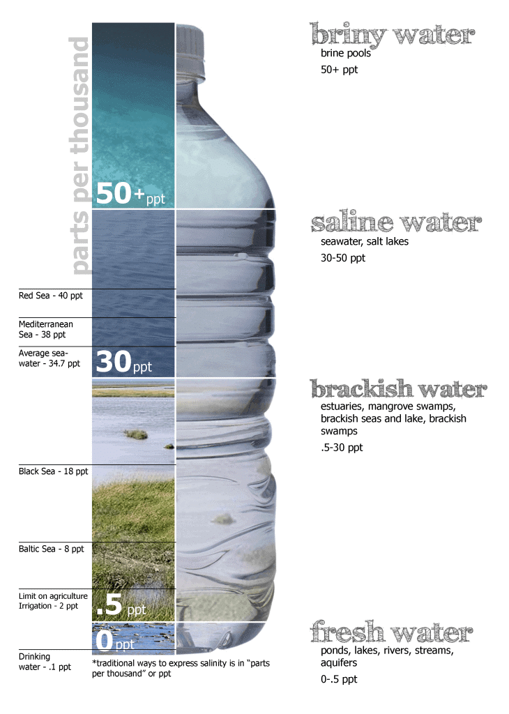
- Salinity means the total content of dissolved salts in Sea or Ocean.
- Salinity is calculated as the amount of salt dissolved in 1,000 gm of seawater.
- It is generally expressed as ‘parts per thousand’ (ppt).
- A salinity of 24.7% has been regarded as the upper limit to fix ‘brackish water’.
- It is a significant factor in deciding several characteristics of the chemistry of natural waters and biological processes.
- Isohalines are used on maps to show the salinity of different places.
- Isohalines – lines joining places having an equal degree of salinity.
- The ocean's average salinity is 35.2% or 35 parts of salt in 1000 parts of water.
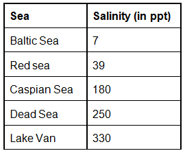
The Great Salt Lake's salinity, (Utah, USA), the Dead Sea, and the Lake Van in Turkey are 220, 240, and 330 respectively. The oceans and salt lakes become saltier as time goes on because the rivers dump more salt into them, while freshwater is lost due to evaporation. known as
Role of Ocean Salinity
- Salinity determines compressibility, thermal expansion, temperature, density, absorption of insolation, evaporation, and humidity.
- It also influences the sea's composition and movement: water and the distribution of fish and other marine resources.
Share of different salts is as shown below:
- sodium chloride - 77.7%
- magnesium chloride - 10.9%
- magnesium sulphate - .4.7%
- calcium sulphate - 3.6%
- potassium sulphate - 2.5%
Factors Affecting Salinity of Ocean Water
There are parts of the ocean where hardly any rain falls, but warm, dry winds cause lots of evaporation. This evaporation removes water- when water vapour rises into the atmosphere, it leaves the salt behind, so the seawater's salinity increases. This causes the seawater to become denser. The north and south Atlantic have high salinity – these are areas where there are strong winds and not much rain.
The Mediterranean Sea in Europe has a very high salinity – 38ppt or more. It is almost closed to the main ocean, and there is more evaporation than there is rain or extra freshwater added from rivers.
➤ Rate of evaporation
- Compare to the temperate latitude ocean, the ocean between 20°N and 30°N latitudes has higher salinity because of a higher rate of evaporation (because of high temperature).
- But this doesn’t mean that tropical oceans will have higher salinity because of the points mentioned in the next point.
➤ The amount of freshwater added by precipitation, streams and icebergs
- The places having high daily rainfall, high relative humidity, and addition by freshwater have low salinity.
- Example: Oceans into which huge rivers like Amazon, Congo, Ganges, Irrawaddy, and Mekong drain have lower salinity.
- The Baltic, Arctic, and Antarctic waters have a salinity of <32 ppt because much freshwater is added from the melting of icebergs and several large poleward bound rivers.
➤ The degree of water mixing by currents
- Land-locked regions (enclosed by lands) have higher salinity because of no freshwater + continuous evaporation. E.g., Black Sea, Caspian Sea, red sea, Persian Gulf.
- The range of salinity is negligible where there is free mixing of water by surface and subsurface currents.
Horizontal distribution of salinity
To make life easier, I will remove the symbol o/oo and place the only number.
- The salinity for normal open ocean ranges between 33 and 37.
➤ High salinity regions
- In the landlocked Red Sea (don’t confuse this to the Dead Sea with much greater salinity), it is as high as 41.
- In hot and dry regions, where evaporation is high, the salinity sometimes reaches 70.
➤ Comparatively low salinity regions
- The estuaries (enclosed mouth of a river where fresh and saline water get mixed) and the Arctic, the salinity fluctuates from 0 – 35, seasonally (freshwater coming from ice caps).
➤ Pacific
- The salinity variation in the Pacific Ocean is mainly due to its shape and larger areal extent.
➤ Atlantic
- The average salinity of the Atlantic Ocean is around 36-37.
- The equatorial region of the Atlantic Ocean has a salinity of about 35.
- Near the equator, heavy rainfall, high relative humidity, cloudiness, and calm air of the doldrums.
- The polar areas experience very little evaporation and receive large amounts of freshwater from ice melting. This leads to low levels of salinity, ranging between 20 and 32.
- Maximum salinity (37) is observed between 20° N and 30° N and 20° W – 60° W. It gradually decreases towards the north.
➤ Indian Ocean
- The average salinity of the Indian Ocean is 35.
- The low salinity trend is observed in the Bay of Bengal due to the river water influx by the river Ganga.
- On the contrary, the Arabian Sea shows higher salinity due to high evaporation and a low influx of freshwater.Question for Ocean SalinityTry yourself:Which of the following seas has the highest average salinity?View Solution
➤ Marginal seas
- Despite its location in higher latitudes, the North Sea records higher salinity due to more saline water brought by the North Atlantic Drift.
- Baltic Sea records low salinity due to the influx of river waters in large quantities.
- The Mediterranean Sea records higher salinity due to high evaporation.
- Salinity is, however, very low in the Black Sea due to the enormous freshwater influx by rivers.
➤ Inland seas and lakes
- The Inland Seas and lakes' salinity is very high because of the regular salt supply by ‘ the rivers falling into them.
- Their water becomes progressively more saline due to evaporation.
- For instance, the Great Salt Lake's salinity, (Utah, USA), the Dead Sea, and the Lake Van in Turkey are 220, 240, and 330 respectively.
- The oceans and salt lakes become saltier as time goes on because the rivers dump more salt into them, while freshwater is lost due to evaporation.
➤ Cold and warm water mixing zones
- Salinity decreases from 35 – 31 in the western parts of the northern hemisphere because of the influx of melted water from the Arctic region.
➤ Sub-Surface Salinity
- With depth, the salinity also varies, but this variation again is subject to latitudinal difference. Cold and warm currents also influence the decrease.
- In high latitudes, salinity increases with depth. In the middle latitudes, it increases up to 35 metres, and then it decreases. At the equator, surface salinity is lower.
Vertical Distribution of Salinity
- Salinity changes with depth, but the way it changes depends upon the location of the sea.
- Salinity at the surface increases by the loss of water to ice or evaporation or decreased by freshwaters' input, such as from the rivers.
- Salinity at depth is very much fixed because there is no way water is ‘lost’, or the salt is ‘added.’ There is a marked difference in the salinity between the surface zones and the deep zones of the oceans.
- The lower salinity water rests above, the higher salinity dense water.
- Salinity, generally, increases with depth and there is a distinct zone called the halocline (compare this with thermocline), where salinity increases sharply.
- Other factors being constant, increasing the salinity of seawater causes its density to increase. High salinity seawater, generally, sinks below the lower salinity water. This leads to stratification by salinity.
Salt Budget
It is also known as the salt cycle. It involves all the processes through which salt moves from the ocean into the lithosphere, to a certain extent into the atmosphere, and back into the oceans.
- Moving water, including groundwater, leaches minerals from the rocks through the process of surface erosion. The mineral-laced water joins the rivers and streams which finally reach the oceans. These minerals add to the salinity levels of the ocean waters.
- Some of the salts in the ocean waters accumulate at the ocean bottom through sedimentation, turning into mineralized rocks. Over a period of millions of years, some of these rocks get raised above the ocean surface due to plate tectonics or volcanic activity. This brings the salt back to the lithosphere in the form of minerals (rocks).
- Salt from the oceans also gets sprayed into the atmosphere due to the action of wind. This salt returns to the lithosphere mixed with precipitation. However, this constitutes a tiny fraction of salt moving from the land to the sea and vice versa.
- Salt cycle operates over a very long period of time.
Every year, around 3 billion tons of salt gets added to the oceans from the land. A tiny fraction of this salt is extracted by humans for daily consumption.
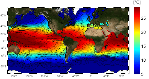
The temperature of ocean water
- The water warms up and cools faster than land and so the ocean’s annual range of temperature is small.
- For open seas, it is –ve 12°C (<10°F)
- It decreases from the equator (21°C) towards 45°latitude N and S (12°C) and freezes at poles.
- But it didn’t remain constant with latitude because it depends on many factors like warm and cold currents, winds, and air masses.
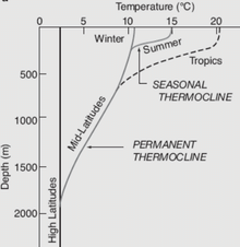
- The temperature-depth profile for the ocean water shows how the temperature decreases with the increasing depth. The profile shows a boundary region between the surface waters of the ocean and the deeper layers.
- The boundary usually begins around 100 – 400 m below the sea surface and extends several hundreds of meters downward (see image). This boundary region, from where there is a rapid decrease of temperature, is called the thermocline.
Horizontal Temperature Distribution of Oceans
- The average temperature of the oceans' surface water is about 27°C, and it gradually decreases from the equator towards the poles.
- The rate of decrease of temperature with increasing latitude is generally 0.5°C per latitude.
- Isothermal lines show the horizontal temperature distribution, i.e., lines joining places of equal temperature.
- Isotherms are closely spaced when the temperature difference is high and vice versa.
- For example, in February, isothermal lines are closely spaced in the south of Newfoundland, near the west coast of Europe and the North Sea, and then isotherms widen out to make; a bulge towards the north near the coast of Norway. The cause of this phenomenon lies in the cold Labrador Current flowing southward along the North American coast which reduces the temperature of the region more sharply than in other places in the same latitude; at the same time, the warm Gulf Stream proceeds towards the western coast of Europe and raises the temperature of the west coast of Europe.
|
263 videos|875 docs|232 tests
|
FAQs on Ocean Salinity - Geography for UPSC CSE
| 1. What is the average salinity of ocean water? |  |
| 2. How does salinity of ocean water affect marine life? | |
| 3. What factors affect the salinity of ocean water? | |
| 4. How does the horizontal distribution of salinity vary in the ocean? | |
| 5. How does the vertical distribution of salinity change in the ocean? | |


Semester Notes
,Summary
,study material
,video lectures
,MCQs
,Free
,mock tests for examination
,Exam
,Objective type Questions
,ppt
,past year papers
,Ocean Salinity | Geography for UPSC CSE
,practice quizzes
,Viva Questions
,Previous Year Questions with Solutions
,Ocean Salinity | Geography for UPSC CSE
,Ocean Salinity | Geography for UPSC CSE
,shortcuts and tricks
,Sample Paper
,Important questions
,Extra Questions
,


Ocean Salinity Free PDF Download
Importance of Ocean Salinity
Ocean Salinity Notes
Ocean Salinity UPSC Questions
Study Ocean Salinity on the App
|
© EduRev
|
Education Revolution
|


|


