Hot and Cold Deserts | Geography for UPSC CSE PDF Download
| Table of contents |
|
| Hot Desert |
|
| 1. Sahara |
|
| 2. Thar Desert |
|
| The Cold Desert |
|
| Characteristics of Cold Deserts |
|
| Challenges related to Cold deserts |
|
| Ladakh |
|

Hot Desert
1. Sahara
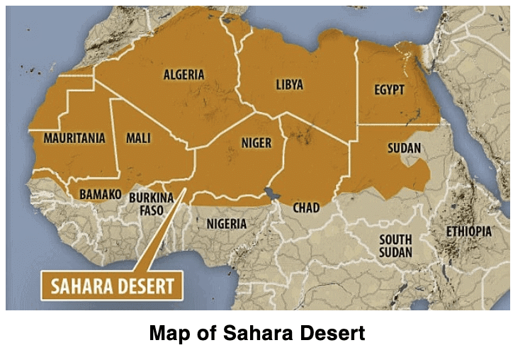
- Sahara is the largest hot desert in the world and the third-largest behind Antarctica and Arctic, which both are cold deserts.
- The name of the desert comes from the Arabic word Sahra, which means Desert.
- Sahara is one of the harshest environments on earth, covering 3.6 million square miles, nearly a third of the Africa continent about the size of the United States of America.
- Sahara is bordered by the Atlantic ocean on the west, The Red Sea on the east, the Mediterranean sea on the north and the Sahel savannas on the south.
- Sahara desert touches 11 countries: Algeria, Chad, Egypt, Libya, Mali, Mauritania, Morocco, Niger, Sudan, Tunisia, and Western Sahara.
The vast stretches of sands that the Sahara desert is covered with, there are also gravel plains and elevated plateaus with bare Rock surfaces. These Rockey surfaces may be more than 2500m high at some places.
Mount Koussi, an extinct volcano in Chad, is the highest point at the Sahara at 3415 meters, and the Qattara Depression in Egypt is the Sahara's deepest point, at 133m below sea level.
Climate
- The climate of the Sahara desert is scorching hot and parch dry. It has a short rainy season. The sky is cloudless and clear. Here, the moisture evaporates faster than it accumulates.
There is no cold season in the hot desert, and the average summer temperature is high, around 30°C. The highest temperature recorded is 57.77°C in 1922 at AL Aziza Libya.
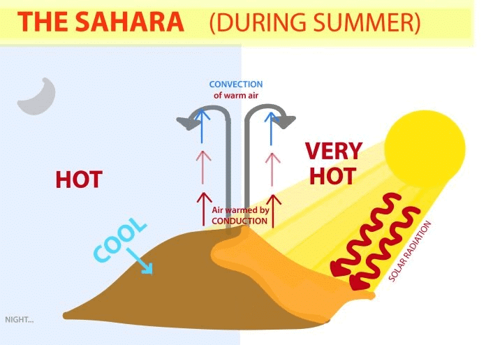
The reasons for the high temperature are obvious a clear, cloudless sky, intense insolation, dry air, and a rapid rate of evaporation.
Coastal deserts by virtue of their maritime influence and the cooling effect of the cold currents have much lower temperatures.
Desert interior, however, experiences a much higher summer temperature, and the winter months are rather cold.
The diurnal range of temperature in the desert is very significant. Intense insolation by day in a reason of dry air and no cloud causes the temperature to rise with the sun.
But as soon as the sun sets, the land loses heat very quickly by radiation, and the mercury level drops.
Vegetation
- The predominant vegetation of both hot and mid-latitude deserts is xerophytes or drought resistance.
- Vegetation in the Sahara desert includes cactus, date palm, and acacia.
- Trees are rare except where there is abundant groundwater to support clusters of date palms.
- Most desert shrubs have long roots for the search for groundwater.
- Plants have fewer leaves, and the folios are either waxy, hairy, or needle-shaped to reduce the loss of water through transpiration.
People
- The Sahara desert despite its harsh climate has been inhabited by various groups of people, who pursue different activities. Among them are the Bedouins and Tuaregs.
- These groups are nomadic tribes rearing livestock such as goats, sheep, camels and horses. These animals provide them with milk, hides from which they make leather for belts, slippers, water bottles; hair is used for mats, carpets, clothes and blankets.
- They wear heavy robes as protection against dust storms and hot winds. The oasis in the Sahara and the Nile Valley in Egypt supports the settled population.
- Since water is available, the people grow date palms. Crops such as rice, wheat, barley, and beans are also grown. Egyptian cotton, famous worldwide is grown in Egypt.
- The discovery of oil – a product in great demand throughout the world, in Algeria, Libya and Egypt is constantly transforming the Sahara desert. Other minerals of importance that are found in the area include iron, phosphorus, manganese and uranium.
- The cultural landscape of the Sahara is changing. Gleaming glass-cased office buildings tower over mosques and superhighways crisscross the ancient camel paths. Trucks are replacing camels in the salt trade. Tuaregs are seen acting as guides to foreign tourists. More and more nomadic herdsmen are taking to city life finding jobs in oil and gas operations.
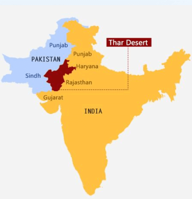
2. Thar Desert
- To the northwest of the Aravali hills lies the Great Indian desert.
- It is a land of undulating topography dotted with longitudinal dunes and barchans.
- This region receives low rainfall below 150 mm per year; hence, it has an arid climate with low vegetation cover.
- It is because of these characteristic features that this is also known as Marusthali.
- It is believed that during the Mesozoic era, this region was under the sea.
- This can be corroborated by the evidence available at wood fossils park at Aakal and marine deposits around Brahmsar, near Jaisalmer (The approximate age of the wood fossils is estimated to be 180 million years).
- Though the underlying rock structure of the desert is an extension of the Peninsular plateau yet, due to extremely arid conditions, its surface features have been carved by physical weathering and wind actions.
- Some of the wells pronounced desert land features present here are mushroom rocks, shifting dunes, and oasis (mostly in its southern part).
- On the basis of the orientation, the desert can be divided into two parts: the northern part is sloping towards Sindh and the south towards the Rann of Kachchh.
- Most of the rivers in this region are ephemeral.
- The Luni river flowing in the southern part of the desert is of some significance. It originates near Pushkar in two branches, i.e., the Saraswati and the Sabarmati, which join with each other at Govindgarh. From here, the river comes out of Aravali and is known as Luni.
- Low precipitation and high evaporation make it a water-deficit region.
The Cold Desert
- These deserts are often situated on plateaus and a part of Continental interiors. They include the Gobi desert, Turkestan desert, Patagonian desert, etc.
- India, Ladakh Desert falls under this category.
- Winter experiences freezing temperatures, and extremely cold winds blow over these regions. Ice thaws during the summer, sometimes causing floods at many places.
- A cold desert biome with harsh climatic conditions, which can be attributed to two factors:
(i) Its location on the leeward side of the Himalayas, which makes it a rain shadow zone inaccessible to the annual south Eastern monsoon winds that sweep the rest of the country, thus creating desert conditions with a low level of precipitation
(ii) Its very high elevation (ranging from 3000 - 5000 meter) that adds to the coldness in its environment, snowstorms, and avalanches are common 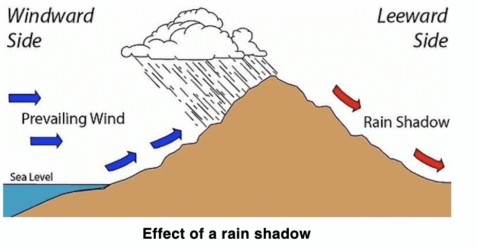
What are Cold deserts?
- A cold desert is an arid habitat with an annual rainfall of less than 25 cm. They have a temperate climate with scorching summers and chilly winters because they are situated at a high latitude in the interior of the continent.
- Here weather and soil are not suitable for plant growth. Hence land is bereft of vegetation except for isolated, scattered and overgrazed herbaceous shrubs.
- The grazing period is less than 3-4 months and it is mainly during the hot season only.
- It generally occurs in Ladakh, Leh and Kargil areas of Kashmir and the Spiti valley of Himachal Pradesh.
Classifications
- Dry temperate zone: Vegetation includes – Betula utilis, Salix spp, Juniperus recurva
- Alpine Zone: Vegetation includes – Junipers, Birch, Rhododendron with grass
- Perpetual snow zone: No vegetation due to permanently frozen soil
The distribution of cold deserts is depicted on the map. Some of them are
- North America – Great basin
- South America – Atacama Desert, Patagonian desert
- Eurasia – Iranian desert, Gobi desert, Turkestan
- Africa – Namib Desert
Characteristics of Cold Deserts
- Most of the time, the temperature is below zero degrees Celsius, which prevents plants from absorbing water.
- Due to the extremely dry atmosphere and low mean annual rainfall (less than 400 mm), the area has a desert-like characteristic.
- Snowfall is heavy and occurs between late November and early April.
- Wind erosion is more common.
- Soil is sandy to sandy loam and neutral to sight alkaline in nature.
- Soil has poor organic matter content and low water retention capacity.
- The growing period is narrow which is mostly during the summer season.
Challenges related to Cold deserts
- While certain disasters (such as earthquakes) might happen instantly, others (such as tornadoes) can take hours, months, or even years to materialize. According to how they begin, environmental hazards and associated natural disasters are divided into two groups:
- Disasters with a slow start, like drought or desertification, develop gradually, making it challenging to predict when they will start and stop. There is no single indicator or index that can accurately pinpoint the beginning and severity of the event; the duration might range from months to years. The effects are typically non-structural and challenging to measure.
- Drought occurrences, which can be categorised as meteorological, hydrological, or agricultural droughts, occur when there is insufficient water to meet the regular needs of agriculture, cattle, industry, or the human population.
- Desertification takes place on bigger time- and space scales. Additionally, because of their possible length of time, the focal point frequently changes over time, necessitating ongoing monitoring of climate and water supply indicators.
- Rapid-onset disasters are defined by the impacts’ suddenness and acute intensity over a brief period of time. The loss of lives and property caused by a specific disaster event is typically used to measure the severity of rapid-onset disasters. Rapid-onset catastrophes do not allow individuals enough time to reduce the danger of an event happening because of the way they start.
- The Himalayan region is extremely vulnerable to rapid-onset hydrologic, meteorological, and geologic disasters because of its fragility, geo-tectonic features, and extraordinary susceptibility to climate change. Due to the area’s remoteness and accessibility, it is difficult to respond in a timely manner, and the lack of a thorough understanding of its natural dynamics makes it difficult to take precautions or issue alerts or early warnings.
- Geo-physical Disasters: They come from events or natural earth processes. The term “geological hazard” refers to both geomorphic processes such as mass movements like landslides, rockslides, rock falls, avalanches, the surface collapses, etc. as well as internal earth processes of tectonic origin, such as earthquakes, geological fault activity, tsunamis, and volcanic activity.
- The mass movements occurring at a greater pace are more dangerous e.g. rock falls, which often occur without any warning.
- Drought frequency is rising due to global warming, which dries up water holes. The frequency of wildfires that change desert landscapes by destroying slow-growing trees and shrubs and replacing them with quickly-growing grasses may increase as temperatures rise.
- The low adaptive capacity of the socio-ecological system.
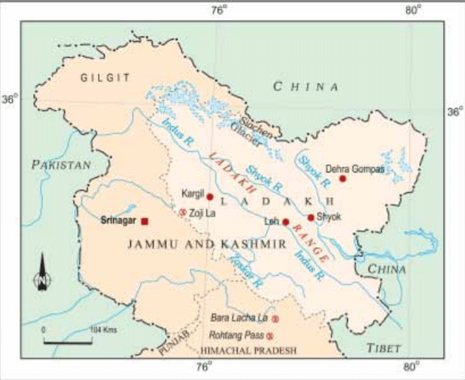
Ladakh
Ladakh is a cold desert lying in the great Himalayas, on the eastern side of Jammu and Kashmir.
- The Karakoram Range in the north and the Zanskar mountains in the south enclose it. Several rivers flow through Ladakh, Indus being the most important among them.
- The rivers form deep valleys and gorges. Several glaciers are found in Ladakh, for example the Gangri glacier.
- The altitude in Ladakh varies from about 3000m in Kargil to more than 8,000m in the Karakoram. Due to its high altitude, the climate is extremely cold and dry.
- The air at this altitude is so thin that the sun's heat can be felt intensely. The day temperatures in summer are just above zero degree and the night temperatures well below –30°C. It is cold in the winters when the temperatures may remain below –40°C for most of the time.
 View Answer
Note:
As it lies in the rain shadow of the Himalayas, there is little rainfall, as low as 10 cm every year. The area experiences freezing winds and burning hot sunlight. You will be surprised to know that if you sit in the sun with your feet in the shade, you may suffer from both sunstroke and frostbite at the same time.
Flora and Fauna
- Due to high aridity, the vegetation is sparse. There are scanty patches of grasses and shrubs for animals to graze. Groves of willows and poplars are seen in the valleys. During the summers, fruit trees such as apples, apricots, and walnuts bloom.
- Several species of birds are sighted in Ladakh. Robins, redstarts, Tibetan snowcock, raven and hoopoe are common. Some of these are migratory birds. The animals of Ladakh are wild goats, wild sheep, yak and special kinds of dogs.
- The animals are reared to provide for the milk, meat and hides. Yak’s milk is used to make cheese and butter. The hair of the sheep and goat is used to make woollens.
People
- Several Buddhist monasteries dot the Ladakhi landscape with their traditional ‘gompas’. Some famous monasteries are Hemis, Thiksey, Shey, and Lamayuru.
- In the summer season, the people are busy cultivating barley, potatoes, peas, beans, and turnip.
- The climate in the winter months is so harsh that people keep themselves engaged in festivities and ceremonies. The women are very hard working. They work not only in the house and fields, but also manage small businesses and shops.
- Leh, the capital of Ladakh is well connected both by road and air. The National Highway 1A connects Leh to Kashmir Valley through the Zoji la Pass.
- Tourism is a major activity with several tourists streaming in from India and abroad. Visits to the gompas, treks to see the meadows and glaciers, witnessing ceremonies and festivities are important activities.
- Life of people is changing due to modernisation. But the people of Ladakh have learned to live in balance and harmony with nature over the centuries. Due to scarcity of resources like water and fuel, they are used with reverence and care. Nothing is discarded or wasted.
|
175 videos|619 docs|192 tests
|


Semester Notes
,video lectures
,Free
,Exam
,past year papers
,Hot and Cold Deserts | Geography for UPSC CSE
,MCQs
,ppt
,Objective type Questions
,Hot and Cold Deserts | Geography for UPSC CSE
,Previous Year Questions with Solutions
,Sample Paper
,Extra Questions
,Summary
,Hot and Cold Deserts | Geography for UPSC CSE
,shortcuts and tricks
,Viva Questions
,study material
,Important questions
,mock tests for examination
,practice quizzes
;


Hot and Cold Deserts Free PDF Download
Importance of Hot and Cold Deserts
Hot and Cold Deserts Notes
Hot and Cold Deserts UPSC Questions
Study Hot and Cold Deserts on the App
|
© EduRev
|
Education Revolution
|


|


within 7 days!