Deserts: Indian Geography | Geography for UPSC CSE PDF Download
| Table of contents |
|
| Introduction |
|
| Climatic Conditions |
|
| Reasons for the formation of Deserts |
|
| Tropical Deserts |
|

Introduction
- Desert regions are characterized by very little rainfall and scanty vegetation, with extreme weather conditions and usually fewer plants.
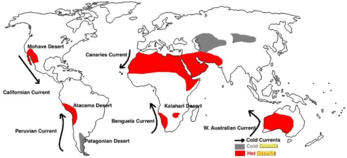
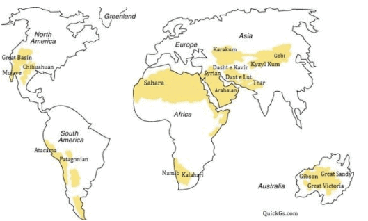 Important Deserts of the World Map
- Deserts can be either Cold or Hot.
- The aridity of the hot desert is mainly due to the effect of off-shore trade winds. Hence, they are also called trade wind deserts.
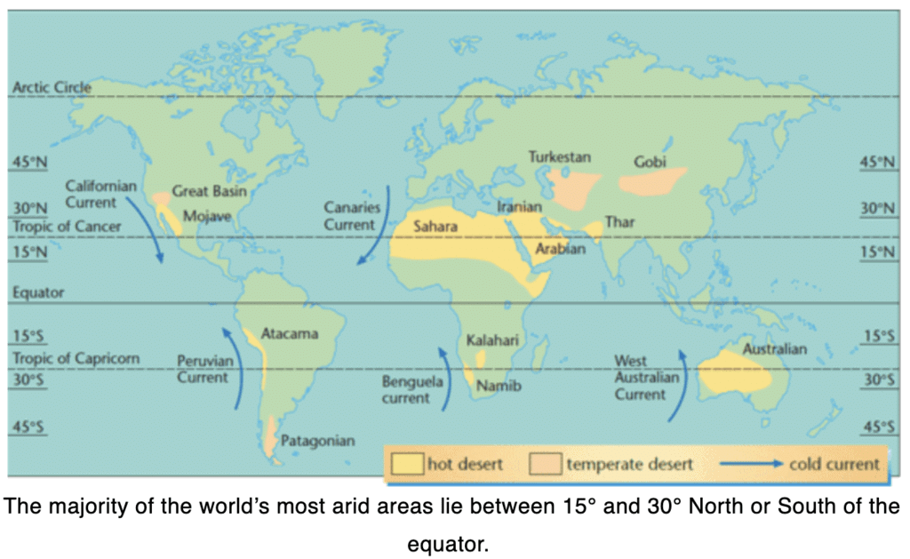
The major hot deserts of the world are located on the western coasts of continents between latitude 15°and 30°North and South of the equator because:
- Offshore trade winds in the region and location in the rain shadow zone: Trade winds that blow in the area shed their moisture on the eastern part, and by the time they reach the western margin, they become dry.
- Anticyclonic conditions: Areas between 20–30 degree latitudes on the western margins of continents are the regions of descending air. It means the air gets compressed and warm as it drops, and thus the moisture-holding capacity keeps decreasing.
- Leeward sides of mountains/Parallel mountain ranges: In the case of few deserts, mountains are situated as a barrier that prevents orographic rainfall. For example- the presence of the Rockies on the western coast of North America does not let moisture-bearing winds rainfall on leeward sides. In the case of the Thar desert in India, Aravallis are situated parallel to the region. Therefore the moisture-holding winds pass away from the area because there is an absence of mountain barriers.
- Cold ocean currents along the western coast of continents tend to stabilize the air over the coast. This prevents cloud formation and rainfall.
1. Desert occupy 1/5th of the world’s land 2. All deserts are absolutely barren and nothing grow Select the CORRECT code given below
Climatic Conditions
1. Rainfall
- Occurs mostly because of convectional rainfall and thunderstorms.
- In cold deserts in Asia, rainfall occurs because of occasional western disturbances and in the form of snow.
- The aridity of deserts is the most outstanding feature of the desert climate.
- Few deserts, whether hot or mid-latitude, have annual precipitation of more than 10 inches while in others less than 0.02 inches.
- The hot deserts lie astride the Horse Latitudes or the Sub- Tropical High-Pressure Belts where the air is descending, a condition least favorable for precipitation of any kind to take place.
- The location of the Hadley Cell (and the ITCZ) has a significant impact on the location of the world's deserts.
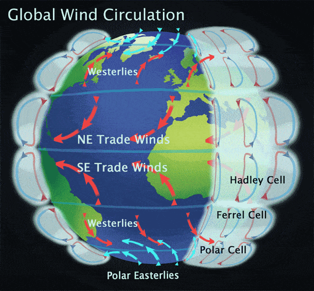
Global Wind Circulation
- The rain-bearing trade winds blow offshore, and the Westerlies, which are on-shore, blow outside the desert limits.
- Whatever winds reach the deserts blow from the cooler to the warmer regions, and their relative humidity is lowered, making condensation almost impossible.
2. Temperature
Coastal deserts generally have less temperature than interiors due to cold currents. Ranges are also high in interiors.
The annual range of temperature is higher in cold deserts compared to hot deserts. Mostly because they are located in mid-latitudes where variation in insolation is highest and because they are located deep inside continents.
Hot deserts are some of the hottest spots on earth and have high temperatures throughout the year.
There is no cold season in the hot deserts, and the average summer temperature is around 30°C.
The highest shade temperature recorded is 58°C at Al Azizia, 25 miles south of Tripoli, Libya, in the Sahara.
The diurnal range of temperature in the deserts is very significant.
3. Natural Vegetation
- All deserts have some form of vegetation such as grass, scrub, herbs, weeds, roots, or bulbs.
- Shrubs remain dormant for years waiting for rainfall. They also have long roots, modified leaves, and stems. Seeds have thick, tough skins and lie dormant until it rains.
- High evaporation means salts are brought upwards, and they accumulate on the surface, forming hardpans. Soil is also deficient in humus.
- Though they may not appear green and fresh all the time, they lie dormant in the soil awaiting rain which comes at irregular intervals or once in many years.
- The environment, so lacking in moisture and excessive heat, is most unfavorable for plant growth, and significant vegetation cannot be expected.
- The predominant vegetation of both hot and mid-latitude deserts is xerophytes or drought-resistant scrub.
- This includes the bulbous cacti, thorny bushes, long-rooted wiry grasses, and scattered dwarf acacia.
- Trees are rare except where there is abundant groundwater to support clusters of date palms.
Life in the Deserts
Despite their inhospitable conditions, different types of human settlements have come up in these deserts:
- Primitive hunters and gatherers: They are primitive tribes who do not cultivate any crops or domesticate any animals. They include the Bushmen of the Kalahari desert, Bindibu, or the Aborigines of Australia.
- Nomadic herdsmen: They pursue a livestock economy, wandering through the deserts along with their herds in search of water and green pastures. They include Bedouins of Arabia, the Tuaregs of Sahara, the Mongols of the Gobi desert.
- Settled cultivators: They have survived close to rivers such as the Nile in Egypt, Indus in Pakistan, Colorado in the USA, and Tigris-Euphrates in Iraq. They cultivate crops like wheat, barley, sugarcane, fruits, and vegetables.
- Mining settlers: Prominent among these include the gold mines in Australia, Diamond mines in Kalahari, Copper mines in Chile, Silver mines in Mexico, Oil in the Persian Gulf countries.
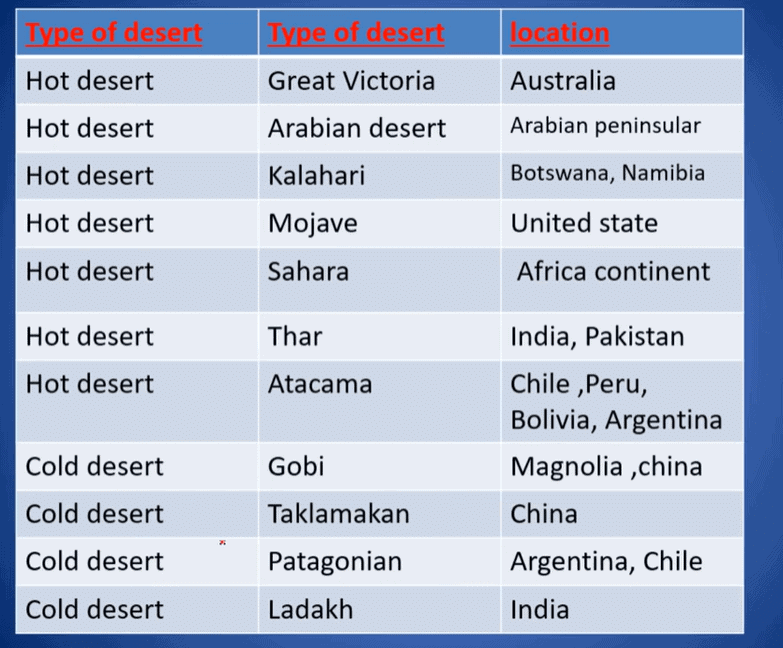 Hot and Cold Deserts of the world
Reasons for the formation of Deserts
1. Equatorial wind belts: The raising of warm air at the equator causes the wind belts which flow to the north and south of the equator, which ultimately forms the desert in the world. Due to the dryness of air at the tropics of cancer and Capricorn, clouds are not formed. Since there is a lack of rainfall, deserts are formed.
2. Rainshadow: It also results in Deserts. When the air passes by high mountain ranges, the moisture content in the air reduces; thus, the land receives less rainfall beyond mountain ranges. An example is the Gobi Desert.
3. Cold Currents: The sweeping of cold currents upwelling from the ocean floor in the southwestern coasts of Africa and South America by the air makes the air that passes over these currents will get cold. Causing the water in the air to fall as rain before it reaches the land. The Namib and Atacama deserts are examples of this phenomenon to form deserts.
Note:
The aridity of hot deserts is mainly due to off-shore trade winds. The aridity of cold deserts is because of off-shore westerlies or leeward side effects. Cold deserts are also generally located on high plateaus. Major hot deserts are located on the west side of continents in the 15 - 30º latitude range. Atacama / Peruvian desert is the driest of all deserts (< 1.25 cm p.a.)
1. Extreme Temperature 2. High Precipitation 3. High Evaporation Which of the statements given above is/are CORRECT in this context?
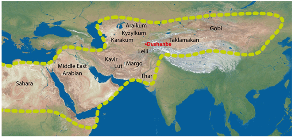
Main reason/reasons for the formation of African and Eurasian desert belts:
- These desert (Sahara, Steppes of Russia) belts lie in the vicinity of cold currents which have a desiccating effect on the air.
- The dust belt (below image) (enclosed by yellow dashes) stretches from the Sahara desert in Africa to the Gobi desert in central and East Asia.
Tropical Deserts
Tropical deserts lie in the trade wind zone but experience little rainfall because easterly trade winds bring rains on the eastern margins of the continents, and western coasts are left dry.
Causes for the formation of Tropical Hot Deserts are:
- The formation of the subtropical high-pressure cell which remains throughout the year - The descending air of the subtropical high adiabatically warms, causing the air to dry out and inhibit condensation.
- The rain shadow effect in the belt of easterly trade winds – Easterly trade winds cause rains only on eastern parts of the continents
- The effect of the cold currents off the west coast of the continents at these latitudes.
Desert Development Program by Government of India
- The desert development program covers both the hot and cold deserts of India.
- Currently, it is run as a part of the IWMP (Integrated Watershed Management Program) scheme and a separate dedicated scheme – Desert Development Program is in Operation which covers states of Haryana, Rajasthan, Gujarat, Jammu and Kashmir, and Himachal.
- Apart from this central scheme, other efforts are also worth noticeable –
- Command Area Development program is now strengthened to extend the reach of projects like Indira Canal to drier areas.
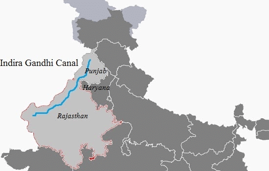 Indira Gandhi Canal on Map
 - Sustainable practices like Dryland farming are being promoted in these areas.
- Social Forestry is being promoted to conserve the land and promote green drive among the dry areas.
|
175 videos|619 docs|192 tests
|
FAQs on Deserts: Indian Geography - Geography for UPSC CSE
| 1. What are some common climatic conditions found in deserts? |  |
| 2. What are the main reasons for the formation of deserts? | |
| 3. What are tropical deserts and where are they usually found? | |
| 4. How does the Indian geography contribute to the formation of deserts? | |
| 5. What are some potential impacts of desertification on the environment and human populations? | |


Deserts: Indian Geography | Geography for UPSC CSE
,past year papers
,Extra Questions
,Free
,video lectures
,Important questions
,Objective type Questions
,Deserts: Indian Geography | Geography for UPSC CSE
,mock tests for examination
,Sample Paper
,ppt
,Viva Questions
,Summary
,Previous Year Questions with Solutions
,shortcuts and tricks
,Semester Notes
,MCQs
,study material
,Deserts: Indian Geography | Geography for UPSC CSE
,Exam
,practice quizzes
;


Deserts: Indian Geography Free PDF Download
Importance of Deserts: Indian Geography
Deserts: Indian Geography Notes
Deserts: Indian Geography UPSC Questions
Study Deserts: Indian Geography on the App
|
© EduRev
|
Education Revolution
|


|


