UPSC Exam > UPSC Notes > Geography CSE > Geography of Antarctica
Geography of Antarctica


Antarctica
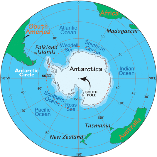
- Antarctica is the southernmost continent and lies entirely within the Antarctic Circle, surrounding the South Pole.
- The continent lies to the south of India beyond the Indian Ocean and is commonly referred to as the frozen continent.
- The name Antarctica literally means "opposite the Arctic".
- It is separated from other continents by the icy waters of the Southern Ocean, which comprises the southern portions of the Indian, Atlantic and Pacific Oceans.
- Its area is over 14 million square kilometres.
- Antarctica is the fifth-largest continent; it is larger than Europe and about twice the size of Australia.
Physical features
- The continent is a high, ice-covered plateau that remains frozen through the year; much of its surface is the ice sheet that sits on a bedrock surface of varying elevation.
- There is effectively no extensive coastal plain; the margin is often occupied by steep ice cliffs, ice shelves and glaciers descending to the sea.
- Antarctica contains mountain ranges, peaks, rift valleys and volcanic centres.
- Two major embayments are the Weddell Sea and the Ross Sea; these along with other geographic features are important in ocean-ice interactions.
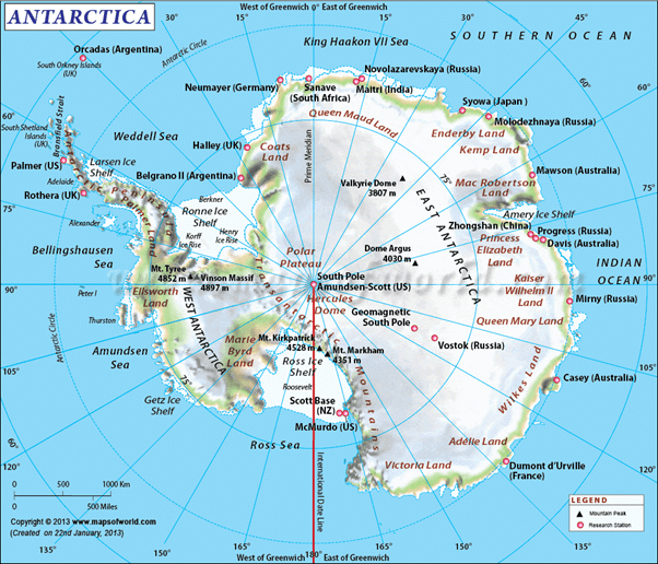
- The Trans-Antarctic Mountains cross the continent and separate it into two main regions: West Antarctica and East Antarctica.
- West Antarctica faces the Pacific sector of the Southern Ocean; the Antarctic Peninsula projects towards South America and is a geological continuation of the Andes.
- East Antarctica faces the Atlantic and Indian sectors and is generally higher and more extensive than West Antarctica.
- Mount Erebus is an active volcano situated in the Ross Sea region (on Ross Island).
- Antarctica is the only continent almost completely covered by permanent ice and snow, earning it the informal name the White Continent.
- In places the ice sheet reaches thicknesses of about 4,000 metres.
- Between some mountain ranges are extremely dry, cold and barren valleys often referred to as oases or dry valleys because they remain largely free of ice and snow.
Climate of Antarctica
- Antarctica's climate is extremely cold due to its high latitude and the great elevation of its central plateau; both factors reduce incoming solar heating.
- At polar latitudes the seasonal cycle produces months of continuous night in winter and months of continuous daylight in summer.
- During the winter months (May, June, July) the sun may not rise at places near the pole and temperatures can fall to about -90°C in the coldest conditions recorded at the South Pole.
- During the summer months (December, January, February) the sun may not set and continuous daylight prevails; summer temperatures in coastal and marginal areas may rise to around 0°C.
- Cold, dense downslope winds called katabatic winds blow frequently and can be extremely strong, influencing coastal and inland climates.
- There is a marked difference between summer and winter temperatures and a large contrast between coastal/marginal regions and the continental interior.
- Most of the continent is very dry: average annual precipitation is very low (order of a few centimetres of water equivalent in much of the interior); Antarctica is therefore technically a cold desert.
- Vegetation is extremely limited: mosses and lichens cling to exposed rocky slopes along some coasts, and scattered clumps of coarse grasses and flowering plants occur only in a few comparatively mild sites.
Aurora
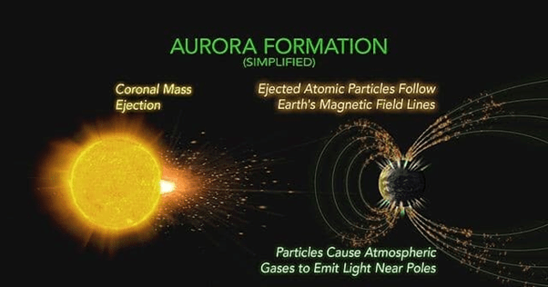
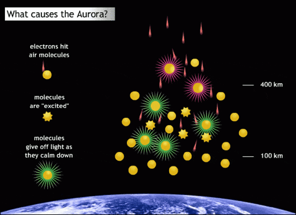
- During the long polar nights brilliant curtains of coloured light appear; these phenomena result from charged particles from the Sun interacting with the Earth's magnetic field and upper atmosphere.
- These displays are commonly called the Aurora Australis in the Southern Hemisphere and the Aurora Borealis in the Northern Hemisphere.

Minerals and water resources
- Scientific investigations indicate presence of mineral resources such as gold, platinum, nickel, copper and potential petroleum-bearing formations beneath continental shelves and sedimentary basins.
- International agreements currently prohibit commercial exploitation of mineral resources while scientific research and environmental protection remain priorities.
- About 70 percent of the Earth's fresh water is locked in the Antarctic ice sheets and glaciers; this represents the largest single store of freshwater on Earth.
Expeditions and Indian Antarctic activity
- In 1912 two teams raced to reach the South Pole: the British expedition led by Captain Robert F. Scott and the Norwegian expedition led by Roald Amundsen. The British party arrived after Amundsen and were beaten by 34 days.
- An Indian expedition consisting of 21 members under the leadership of Dr S. Z. Quasim sailed from Goa on 6 December 1981 and landed on Antarctica on 9 January 1982.
- The expedition established a scientific base named Dakshin Gangotri, planned a second base called Maitri, and named a point Mount Indira.
- Automatic weather recorders powered by solar batteries were left at the stations to record meteorological data.
- The South Pole lies roughly 2,250 kilometres from Dakshin Gangotri (as given by expedition records).
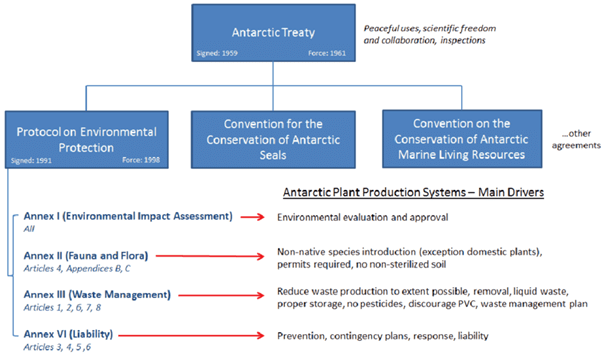
The Antarctic Treaty
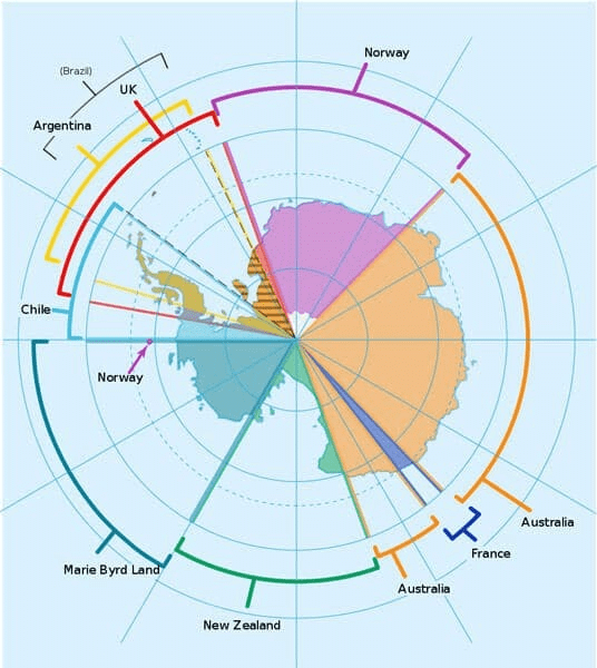
- The Antarctic Treaty was signed in Washington on 1 December 1959 by twelve nations active during the International Geophysical Year (IGY): Argentina, Australia, Belgium, Chile, France, Japan, New Zealand, Norway, South Africa, the United Kingdom, the United States and the USSR.
- The Treaty applies to the area south of 60° South latitude and establishes a legal framework for the continent.
- The Treaty's principal objectives include ensuring that Antarctica is used exclusively for peaceful purposes and preserving the continent for international scientific research.
- Military activities such as the establishment of military bases, weapons testing, or military manoeuvres are explicitly prohibited.
- The Treaty guarantees freedom to conduct scientific research and promotes international scientific cooperation, including exchange of research plans, personnel and scientific results.
- It sets aside sovereignty disputes by stating that no treaty activity shall enhance or diminish previously asserted territorial claims and that no new or enlarged claims may be made.
- The Treaty prohibits nuclear explosions and the disposal of radioactive waste in the Treaty area.
- It provides for inspection by observers designated by any party of ships, stations and equipment to ensure compliance with Treaty obligations.
- Parties are required to give advance notice of their expeditions; regular consultative meetings enable parties to discuss measures to further Treaty objectives and to modify arrangements where necessary; a dispute-settlement procedure is provided.
Engineering, technology and research applications
Civil engineering considerations
- Foundation design must account for ice and permafrost: load-bearing capacity, thaw settlement, and long-term ice flow can affect stability.
- Structures are frequently elevated on stilts or insulated foundations to reduce heat transfer and prevent melting of underlying ice or permafrost.
- Airstrip and runway design on ice or compacted snow require specialised pavement engineering and routine maintenance.
- Materials must tolerate very low temperatures, high wind loads and abrasion from ice and snow; corrosion and brittle fracture are key concerns.
- Construction logistics are complex and costly: prefabrication, modular assembly and seasonal work windows are common strategies.
- Waste management and environmental protection are essential design constraints under international agreements.
- Geotechnical and glaciological surveys (including ice-core drilling) are required to assess subsurface conditions before major construction.
Computer science and data applications
- Remote sensing and geographic information systems (GIS) are central to mapping ice cover, tracking changes in ice sheets and monitoring sea-ice extent.
- Polar-orbiting satellites provide critical data; data processing requires handling large remote-sensing datasets, often using machine learning and numerical models to detect trends.
- Communications are constrained by polar geometry; satellite links, store-and-forward systems and delay-tolerant networking techniques are important for reliable data transfer.
- On-site computing must be resilient to low temperatures, intermittent connectivity and limited power; fault-tolerant and power-efficient computing systems are preferred.
- Telemetry, remote instrument control, data compression and cyber-security for scientific data are key practical topics for computer scientists working on polar projects.
Electrical engineering considerations
- Power generation and distribution at Antarctic stations typically rely on diesel generators with increasing use of wind turbines and solar panels as supplements.
- Battery performance and energy storage systems degrade in cold environments and must be thermally managed.
- Heating loads are significant; electrical systems and cabling must be specified for low-temperature flexibility and insulation.
- Meteorological, seismic and oceanographic instrumentation require reliable low-temperature electronics and redundancy for long unattended operation.
- Radio and satellite communications, antenna siting, and electromagnetic interference mitigation are essential for station operations and science data transfer.
- Designs must prioritise safety, redundancy and maintainability in isolated and hostile conditions.
Summary
- Antarctica is a unique polar continent dominated by an extensive ice sheet, extreme climate and specialised ecosystems along a narrow coastal fringe.
- Its environmental importance, large freshwater stores and international governance under the Antarctic Treaty make it a focus for scientific research rather than commercial exploitation.
- For engineering and technology disciplines, Antarctica offers practical challenges in foundation engineering, materials science, power systems, communications, remote sensing and data analysis; solutions must balance technical feasibility with environmental protection and logistical constraints.
The document Geography of Antarctica is a part of the UPSC Course Geography for UPSC CSE.
All you need of UPSC at this link: UPSC
FAQs on Geography of Antarctica
| 1. What is the geography of Antarctica? |  |
Antarctica is the southernmost continent on Earth and is located almost entirely within the Antarctic Circle. It is surrounded by the Southern Ocean and covers an area of about 14 million square kilometers. The geography of Antarctica is characterized by its vast ice sheets, mountain ranges, and frozen plateaus.
| 2. How is the climate in Antarctica? | |
Antarctica has an extremely cold and harsh climate. It is known as the coldest place on Earth, with temperatures regularly dropping below -50 degrees Celsius (-58 degrees Fahrenheit). The continent experiences strong winds, low humidity, and very little precipitation, mostly in the form of snowfall.
| 3. What are the main geographical features of Antarctica? | |
Antarctica is dominated by its ice sheets, with the East Antarctic Ice Sheet being the largest ice sheet in the world. The continent also has several mountain ranges, including the Transantarctic Mountains and the Ellsworth Mountains. Other notable geographical features include the McMurdo Dry Valleys, which are one of the driest places on Earth, and the Ross Ice Shelf, the largest ice shelf in Antarctica.
| 4. Are there any permanent residents in Antarctica? | |
Antarctica does not have any permanent residents. It is governed by the Antarctic Treaty System, which prohibits any military activity, mineral mining, and nuclear testing on the continent. However, there are research stations operated by various countries, where scientists and support staff stay temporarily to conduct scientific research.
| 5. How does the geography of Antarctica affect its wildlife? | |
The extreme geography of Antarctica, with its freezing temperatures, limited food sources, and vast ice-covered areas, has a significant impact on the wildlife that inhabits the continent. Only a few species, such as penguins, seals, and seabirds, have adapted to survive in this harsh environment. The nutrient-rich waters surrounding Antarctica support a diverse marine ecosystem, including krill, which is a primary food source for many Antarctic species.
About this Document

4.85/5 Rating

Apr 30, 2026 Last updated
Related Exams
Document Description: Geography of Antarctica for UPSC 2026 is part of Geography for UPSC CSE preparation. The notes and questions for Geography of Antarctica have been prepared according to the UPSC exam syllabus. Information about Geography of Antarctica covers topics like and Geography of Antarctica Example, for UPSC 2026 Exam. Find important definitions, questions, notes, meanings, examples, exercises and tests below for Geography of Antarctica.
Introduction of Geography of Antarctica in English is available as part of our Geography for UPSC CSE for UPSC & Geography of Antarctica in Hindi for Geography for UPSC CSE course. Download more important topics related with notes, lectures and mock test series for UPSC Exam by signing up for free. UPSC: Geography of Antarctica
Description
Geography of Antarctica of Geography covers all the important topics, helping you prepare for the UPSC exam on EduRev. Start for free!
Information about Geography of Antarctica
In this doc you can find the meaning of Geography of Antarctica defined & explained in the simplest way possible. Besides explaining types of Geography of Antarctica theory, EduRev gives you an ample number of questions to practice Geography of Antarctica tests, examples and also practice UPSC tests


Related Searches
study material, Extra Questions, Geography of Antarctica, Exam, video lectures, MCQs, Viva Questions, ppt, Geography of Antarctica, Important questions, Sample Paper, Summary, Objective type Questions, Geography of Antarctica, practice quizzes, past year papers, Semester Notes, Previous Year Questions with Solutions, pdf , mock tests for examination, shortcuts and tricks, Free;