Soil Exploration | Foundation Engineering - Civil Engineering (CE) PDF Download
Introduction
Soil investigation and soil explorations are conducted for the purpose of site investigation to get clear information about the soil properties and hydrological conditions at the site.
Site Reconnaissance
An inspection of the site and study of topographical features is often helpful in getting useful information about the soil and groundwater conditions and in deciding the future programme of exploration.
On going over the site, a study of the following features may be useful: local topography, excavations, cuttings, quarries, escarpments, evidence of erosion on land slides, fills, water levels in wells and streams, flood marks, and drainage pattern, etc.
If there has been an earlier use of the site, information should be gathered in particular about the underground workings, if any, and about the location of fills and excavations.
Site Exploration
The object of site exploration is to provide reliable, specific and detailed information about the soil and groundwater conditions of the site which may be required for a safe economic design execution of the engineering work.
The purpose of site exploration is to get detailed information about
- Order of occurrences and extent of soil and rock strata.
- Nature and engineering properties of the soil and rock formation.
- Location of groundwater and its variation.
Methods of Soil Exploration
Different methods of soil exploration for study of soil profiles are:
- Open excavation
- Borings
- Subsurface soundings
- Geographical methods
- Open Excavation
A pit, eventually, can be excavated for exploring shallower depths, say of the order of 2 to 5 m, or so. Such a pit can be easily excavated at the proposed construction site, if the soil has a bit of cohesion, and the soil samples can be lifted from such different depths, besides making the easy visualization and examination of the different strata. Even undisturbed soil samples can be lifted from such a pit by a process called chunk sampling. - Boring Method
Soil samples can be lifted from deeper depths by drilling bore holes by using mechanical devices called samplers.
The process consists of
(i) Drilling a hole and visually examining the cuttings coming out from different depths
(ii) Lifting the soil samples from different depths by using mechanical devices called samplers.
(a) Methods of Boring
(i) Auger boring
This is simplest method of boring a hole by hand drilling. These can be used for shallower depths generally confined to depths of about 5 m or so. In cohesive and other soft soils above water table, augers may be used.
(ii) Auger and Shell boring
Augers are suitable for soft or stiff clays and very stiff and hard clays and sand pumps for sandy soils. Cylindrical augers and shells are used for making deep boring. Hand operated, mechanized ring are used for depths 25m, 50m respectively.
(iii) Wash boring
This is a simple and fastest method, used for making holes in all types of soils except boulders and rocks.
(iv) Percussion boring
This method is used to make hole in all types of soils including boulders and rocks.
(v) Rotary boring (Mud rotary drilling)
This method is used to advance hole in rocks and soils. Rotating core barrels which are provided with commercial diamond bits or a steel bit with slots are used for rotary drilling. This method is used to obtain the rock cores, so this method is called as core boring or core drilling.
(b) Soil samples and sampling for Boring Method of Soil Exploration
(i) Disturbed sample
In disturbed sampling, the natural structures of soils gets partly or fully modified or destroyed, although with suitable precaution the natural water content may be preserved. Disturbed sample can be obtained by direct excavations by auger and thick wall samplers.
(ii) Undisturbed sample
In undisturbed sample, the natural structure and properties remain preserved. These samples are used to tests for shear, consolidation and permeability.
(iii) Non-representative sample
It consists of a mixture of soil from different soil strata. Size of the soil grains as well as the mineral constituents, might thus, have changed in such samples. Soil samples obtained from auger cuttings and settling in some well of wash borings, can be classified in this category. Such samples may help in determining the depths at which major changes may be occurring in subsurface soil strata.
(c) Sample Disturbance
This depends on the design of samplers and methods of samplings.
Design factors governing the degree of disturbances:
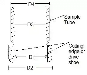
(i) Cutting edge: A typical cutting edge of a sampler is shown in the figure The important design features of the cutting edge are
(i) Area ratio
Where D1 and D2 are internal and external diameters of the cutting edge respectively.
The area ratio should not exceed 25%. For soft sensitive soils, it should not exceed 10%.
(ii) Inside clearance: It allows elastic expansion of sample when it enters the tube.
Where D3 = inside diameter of the sample tube.
The inside clearance must lie between 1 to 10%, for undisturbed sample it should be between 0.5 and 3%.
(iii) Outside clearance: It should not be much greater than the inside clearance. Normally it lies between 0 and 2 percent. It helps in reducing the force required to withdraw the tube.
Where D4 is the external diameter of the sample tube.
(iv) Inside wall friction: The walls of the sampler should be smooth and kept properly oiled.
(v) Non-return valve: The non-return valve should permit easy and quick escape of water and air when the sample is driven. - Subsurface Sounding Tests
These tests are carried out to measure the resistance to penetration of a sampling spoon, a cone or other shaped tools under dynamic or static loading. These tests are used for exploration of erratic solid profiles for finding depth to bedrock or stratum and to get approximate indication of the strength and other properties of soil.
Methods of Subsurface Sounding Tests are:
(i) Standard Penetration Test (SPT)
This test is carried out in a clean hole of diameter about 55 to 150mm. the sides of the holes are supported by casing or drilling mud. A split tube sampler with 50.8mm outer diameter, 38mm inner diameter is driven into the undisturbed soil, placed at the bottom of the hole under the blows of 65kg drive weight with 75cm free fall.
The minimum open length of the sampler is 60cm, the samplers is first driven through 15cm as a seating drive and then through 30cm or until 100 blows have been applied. Number of blows required to drive sampler 30cm beyond the seating drive is known as penetration resistance and it is denoted by N.
When N is greater than 15, Terzaghi and Peck have recommended the use of an equivalent penetration resistance, Ne in place of the actually observed value of N.
Ne = 15 + (1/2)(N - 15)
Gibbs and Holtz have studied experimentally the effect of overburden pressure on the value of N and their modification for air dry or moist sand can be represented by the relation,
Where Ne= Corrected value of overburden effect
N= actual values of blows
σ' = effective overburden pressure (kN/sq.m)
Note: The overburden correction is applied first and then dilatancy correction is applied.
(ii) Cone penetration test or Dutch cone test
This type of test is carried out to get a continuous record of the resistance of the soil by penetrating steadily under static pressure, a cone with base of 10 sq.cm (3.6 cm in dia.) and an angle of 60 degree at the vortex.
To find out the cone resistance, the cone alone is first forced down for a distance of 8cm and the maximum value of resistance is recorded. This test is very useful in finding bearing capacity of pits in cohesionless soil. Cone resistance qc (kg/sq.cm) is approximately equal to 10 times the penetration resistance N. - Geographical Methods of Soil Exploration
(i) Electrical resistivity method
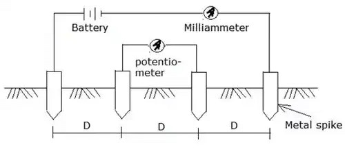
This method is based on the measurement and recording of changes in the mean resistivity or apparent specific resistance of various soils. The test is done by driving four metal spikes to act as electrodes into the ground along a straight line at equal distances. This is shown in the figure.
Direct voltage is applied between the two outer potentiometer electrodes and then mean for the potential drop between the inner electrodes is calculated. Mean resistivity (ohm-cm)
ρ = 2πD(E/I) = 2πDR
Where D = distance between the electrodes (cm)
E = potential drop between outer electrodes (volts)
I = current flowing between outer electrodes (amperes)
R = resistance (ohms)
(a) Resistivity mapping: This method is used to find out the horizontal changes in the sub soil, the electrodes kept at a constant spacing, are moved as a group along the line of tests.
(b) Resistivity sounding: This method is used to study the vertical changes; the electrode system is expanded, about a fixed central point by increasing the spacing gradually from an initial small value to a distance roughly equal to the depth of exploration desired.
(ii) Seismic refraction method
This method is very fast and reliable in establishing profiles of different strata, provided the deeper layers have increasingly greater density, higher velocities and greater thickness.
|
18 videos|46 docs|27 tests
|
FAQs on Soil Exploration - Foundation Engineering - Civil Engineering (CE)
| 1. What is soil exploration in civil engineering? |  |
| 2. Why is soil exploration important in civil engineering? |  |
| 3. What are the methods used for soil exploration in civil engineering? |  |
| 4. What are the factors considered during soil exploration for civil engineering projects? |  |
| 5. How is the data obtained from soil exploration used in civil engineering? |  |


