Weather & Climate | Geography Optional for UPSC PDF Download
Climate refers to the long-term patterns and average conditions of various weather elements, such as temperature, humidity, atmospheric pressure, wind, precipitation, and the concentration of particles in the atmosphere, within a specific region.
Studying any of these individual factors alone does not provide a complete understanding of a region's climate. Instead, it is the combination of these elements that create the various types of climates found around the world. Thus, there could potentially be thousands of unique climates based on the various interactions and patterns of these meteorological variables.
Weather & Climate
Weather
- Weather refers to the short-term state of the atmosphere in a specific location, which includes factors such as temperature, humidity, precipitation, air pressure, wind, and cloud cover. Weather mainly occurs in the troposphere, the lowest region of the atmosphere that extends from Earth's surface up to around 6-8 km at the poles and about 17 km at the equator. This is because the troposphere contains almost all clouds and is where most precipitation forms.
- On the other hand, climate refers to the long-term synthesis of weather conditions that have occurred in a particular area over an extended period, typically 30 years. While weather describes short-term atmospheric phenomena, climate provides an overview of the average weather patterns in a specific region.
- Various factors affect weather, including geographic features such as mountains and large bodies of water like lakes and oceans. Recent research has shown that ocean-surface temperature anomalies can potentially influence atmospheric temperature anomalies in subsequent seasons and distant locations. One example of such an interaction between the ocean and the atmosphere affecting weather is the El Niño/Southern Oscillation (ENSO) phenomenon.
Climate
- Climate refers to the long-term atmospheric conditions in a specific location, encompassing the various elements that make up weather patterns over an extended period.
- The primary factors that contribute to climate include sunlight exposure, temperature fluctuations, levels of humidity, different forms of precipitation (such as rain or snow) and their frequency, atmospheric pressure, and wind patterns in terms of speed and direction.
- In short, climate is a comprehensive representation of the weather-related components that persistently occur in a given area over a considerable length of time.
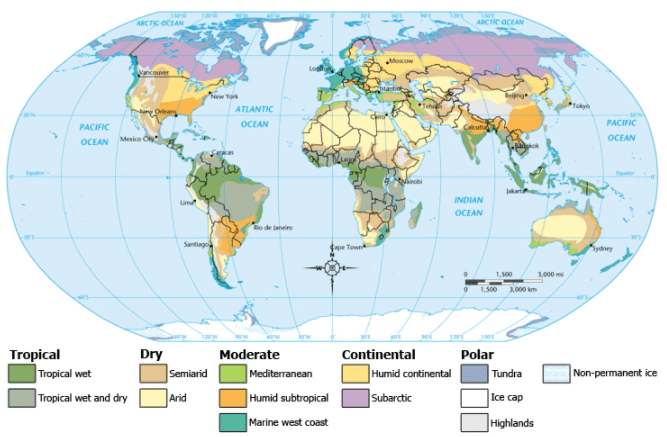
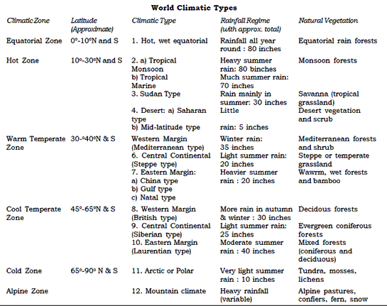
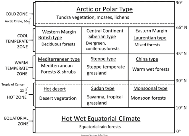
Climatic Regions of World
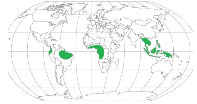
Hot, Wet Equatorial Climate
Distribution
- 50 North – 100 South from equator
- No impact of trade winds, if you go away from this will have monsoon type climate.
- Basically, hot, wet type of climate but also have cool places like Cameron highland in Malaysia because these places are at high altitude.
- Examples of some Countries: Ecuador, Colombia, Brazil, Peru, Nigeria, Liberia, Myanmar, Thailand, Cambodia, Malaysia, Java
Climate
- There is great uniformity of temperature throughout the year.
- The mean monthly temperatures are always around 24 to 27ºC, with very little variation.
- There is no winter.
- The diurnal and annual range of temperature is small.
- Precipitation is heavy between 6o inches and 10 inches, and well distributed throughout the year.
- The double rainfall peaks, coinciding with the equinoxes are a characteristics feature of it.
Natural Vegetation
- It support a luxuriant type of vegetation – the tropical rain forest.
- Amazon tropical rain forest is known as Selvas.
- It comprises a multitude of evergreen trees that yield tropical hardwood, e.g. mahogany, ebony, greenheart, cabinet wood. And dyewoods.
- Lianas, epiphytic and parasitic plants are also found.
- Trees of single species are very scarce in such vegetation.
Economy
- The equatorial regions are generally sparsely populated.
- In the forests, most primitive people live as hunters and collectors and the more advanced ones practice shifting cultivation.
- Some plantation crops are also practiced like natural rubber, cocoa, etc.
Savanna or Sudan Climate (or Tropical Wet and Dry Climate)
- The Savanna or Sudan climate is a transitional type of climate situated between equatorial forests and trade wind hot deserts. This climate is predominantly found within the tropics, specifically between the Tropic of Cancer and the Tropic of Capricorn.
- It is most prominently developed in Sudan, where the distinction between wet and dry climates is most noticeable, hence the name "Sudan climate."
- This climate type encompasses large portions of Africa (such as Kenya, Nigeria, and Gambia), as well as significant areas in Australia, South America (like the Brazilian highlands), and India.
- The Savanna climate is characterized by a distinct dry season that occurs during the winter months, with the majority of rainfall concentrated in the summer season. The extended dry season leads to the death of many plants and the drying up of streams, which in turn forces animals to migrate in search of water and food.
Distribution
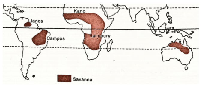
- The Sudan climate is predominantly located within the tropical latitudes, on both sides of the equator, and is characterized by distinct wet and dry seasons. This climate type is named after its well-developed presence in Sudan, Africa.
- In the northern hemisphere, regions with Sudan climate include African Sudan and East Africa, as well as the Llanos grasslands in the Orinoco River basin of South America. In the southern hemisphere, the Sudan climate can be found in the Campos grasslands of the Brazilian Highlands in South America, and in Northern Australia, just south of the monsoonal region.
- Overall, the Sudan climate is typically found in areas close to the equator, spanning across various continents, with its main feature being the clear wet and dry seasons it experiences.
Temperature
- In the savanna region, monthly temperatures typically range from 20 to 32 degrees Celsius in the lowlands, with variations increasing as one moves further from the equator. The average annual temperature in this area is approximately 18 degrees Celsius. The highest temperatures are usually experienced just before the start of the rainy season, which occurs in April in the northern hemisphere and October in the southern hemisphere. Interestingly, June, when the summer solstice takes place in the northern hemisphere, does not see the highest temperatures.
- During the rainy season, the presence of clouds in the sky causes a decrease in temperature levels. In the hot season, temperatures often surpass 37 degrees Celsius during the day. However, clear skies at night lead to a rapid loss of heat, causing temperatures to drop below 10 degrees Celsius even in the hot season. Night frosts are common during this time.
- One notable characteristic of the savanna climate is the significant difference between daytime and nighttime temperatures, also known as the extreme diurnal temperature range.
Precipitation
- The region's climate is marked by two distinct seasons - a hot and wet season, followed by a cooler, dry period. In the northern hemisphere, the warm, rainy season typically lasts from May to September, as seen in Kano, Nigeria. The remainder of the year is characterized by cooler, dry weather. Situated at an elevation of more than 1500 meters above sea level, Kano experiences over 80 centimeters of rainfall, which primarily occurs during the summer months.
- Conversely, in the southern hemisphere, the wet season takes place from October to March. As one moves further from the equator and closer to desert areas, both the duration of the rainy season and the total annual precipitation decrease significantly.
Winds
- Trade winds are the dominant winds in a region that bring rainfall to coastal areas. These winds generally flow from east to west, resulting in the highest rainfall on the eastern coasts. Trade winds are particularly strong during the summer when the Intertropical Convergence Zone (ITCZ) is positioned over hot deserts. As these winds travel over coastal regions, they lose their moisture, and by the time they reach the interiors of continents, they become relatively dry.
- In West Africa, the easterly trade winds carry dry, dusty air from the Sahara, eventually reaching the coast of Guinea. This hot, dry, and dusty wind is locally known as the Harmattan, which means "the doctor." Although the Harmattan can have a negative impact on crops, it also brings a cooling effect, offering some relief from the humid air of Guinea by increasing evaporation rates.
- The trade winds are responsible for the distinct, alternating dry and wet seasons in the region. During the summer, onshore trade winds carry moisture-laden air, resulting in rainfall. In contrast, during the winter, the winds blow offshore, keeping the weather dry.
Vegetation
- The vegetation in this region is characterized by tall grasses and short trees, often referred to as 'bush-veld' or 'parkland'. Tree coverage is most dense near the equator and along riverbanks, and it becomes less dense and shorter as you move away from the equator.
- The trees in this region are typically deciduous, meaning they shed their leaves during the dry and cool seasons to minimize water loss through transpiration. Acacia trees are a common example of this type of vegetation. Other tree species have broad trunks that serve as water storage spaces, allowing them to survive dry seasons or droughts. Examples of these trees include baobabs and bottle trees.
- These trees are often hardwood and may have thorns, and they can produce substances such as gum arabic. The grasses in this area are tall and coarse, growing up to 6-12 feet in height. Elephant grass, the tallest variety, can even reach up to 15 feet tall. The grass has a compact structure and long roots that extend deep into the ground in search of water.
- During the dry season, the grass appears dormant, but it comes back to life during the rainy season. As you move closer to the desert, the grasslands gradually transition into thorny scrublands.
Wildlife
- The savanna is home to some of the largest land animals on Earth, which can be divided into two main categories: herbivores and carnivores.
- Well-known herbivores that inhabit the savanna include zebras, giraffes, elephants, and antelopes. These animals possess unique adaptations to help them survive, such as incredible speed for outrunning predators or exceptional camouflage abilities to avoid detection.
- Key carnivores in the savanna ecosystem consist of lions, hyenas, leopards, panthers, pumas, and jaguars. These predators are equipped with strong jaws and sharp teeth, enabling them to effectively attack and consume their prey.
- In addition to these animals, the savanna also hosts various reptiles, such as crocodiles, monitor lizards, and giant lizards, which can be found along rivers and in marshy areas. Rhinoceroses and hippopotamuses are other notable inhabitants of these wetland regions.
Economy
- The economy of this region largely consists of nomadic pastoralism, settled agriculture, and plantation agriculture. Nomadic pastoralists, such as the Masai found in Kenya and Tanzania, rely on their livestock for survival and maintain a traditional way of life. Settled agriculture is practiced by numerous tribes, such as the Hausa, who have domesticated animals to aid in crop cultivation.
- Plantation agriculture, present in areas like northern Australia, eastern Brazil, and central Africa, highlights the substantial agricultural potential of the region. Crops such as cotton, sugarcane, oil palm, groundnuts, coffee, and tropical fruits are commonly grown. Additionally, tribes cultivate small amounts of millets, bananas, and vegetables for their own consumption.
- However, the region faces challenges such as frequent droughts, which threaten crop cultivation, especially during the extended dry seasons. In many areas, heavy rainfall during the wet season leads to the leaching of topsoil and essential nutrients like nitrates, phosphates, and potash, resulting in lateritic soils that are unsuitable for crop cultivation.
- The poor quality of grass in this region does not support large-scale animal ranches typically found in temperate grasslands, resulting in low meat and dairy production. Despite these challenges, some regions have embraced modern science and technology to become leading exporters of meat and dairy products, such as Queensland in Australia.
Tropical Monsoon Climate
- The tropical monsoon climate, also known as the monsoon climate, can be found in the area between the Tropic of Cancer and the Tropic of Capricorn. This region is affected by the movement of the inter-tropical convergence zone (ITCZ) and experiences hot and humid conditions throughout the year due to the sun's consistent overhead position.
- Monsoons are characterized by seasonal winds that blow across land and sea, causing a shift in wind direction and resulting in variations in temperature and precipitation. These seasonal winds are responsible for the three distinct seasons observed in this climate region: summer, winter, and the rainy season.
Distribution
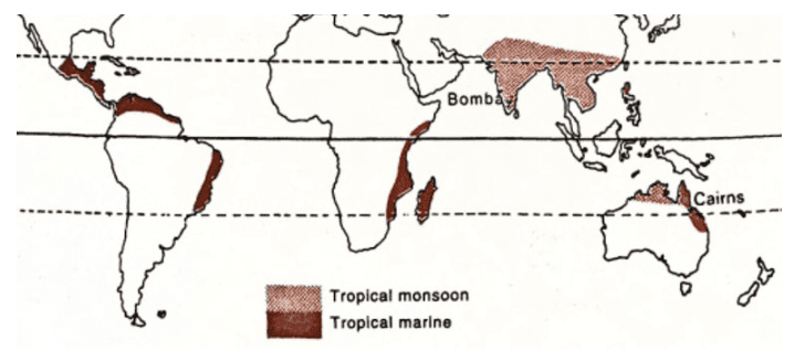
They are confined within 5 – 30 degrees latitudes on either side of the equator.
Indian subcontinent, Indo-China (Laos. Vietnam, Cambodia), Thailand. southern China and northern Australia are the regions experiencing this climate.
- Winds
The seasonal reversal in the direction of winds is an outcome differential rate of heating and cooling of the continental landmasses and seawaters. - During the summers, a low-pressure region develops over Central Asia as the sun comes overhead the Tropic of Cancer. This causes the Asian landmass to heat up faster than the surrounding seas, which remain at a higher pressure in the northern hemisphere.
- In the southern hemisphere, winter conditions prevail, leading to a high-pressure zone over northern Australia.
- Winds blow outward from the Australian landmass towards Java (Indonesia) and are drawn towards the low-pressure region over the Indian subcontinent after crossing the equator, under the influence of the Coriolis force. These are the South-West monsoon winds.
- During winters, a reversal in the wind direction occurs.
Temperature
- Owing to the region’s proximity to the tropics, it experiences warm to hot summers.
- Average monthly temperature is above 18 degrees centigrade, but in summers the maximum can reach as high as 45 degrees centigrade.
- The average temperature in the summer is around 30 degrees centigrade, with an overall temperature range of 30 to 45 degrees centigrade.
- Winters are mild with a temperature range of 15 to 30 degrees centigrade. Mean temperature during winters is around 25 degrees centigrade.
Precipitation
- The region experiences very high rainfall, which is concentrated in a few months.
- Annual average rainfall is around 200-250 cm. However, some regions have a very high average of around 350 cm.
- In India, Maysynram and Cherrapunji of Khasi Hills (Meghalaya) experience an annual rainfall of over 1000cm. They are located on the windward side of the hills, causing heavy orographic rainfall (caused by a lift of the monsoon winds). Due to the location in between mountains which causes a concentration of rain-bearing clouds, also known as the funnelling effect, these places receive very high rainfall.
Seasons
Unlike the equatorial climate which does not have distinct seasons, monsoon climate experiences striking differences in weather conditions based on the seasons.
- The hot dry season
- This lasts from March to mid – June.
- The sun is in a northward shift to the Tropic of Cancer. This causes the temperatures to rise sharply.
- Mean temperatures during the day cross 35 degrees centigrade in Central India. It can reach as high as 44 degrees centigrade in Sindh and also in south India.
- In coastal areas, the temperatures are not so high, due to the influence of sea breezes.
- Except for the occasional thunderstorms, there is little rainfall during this season.
- The rainy season
- This lasts from mid – June to September
- The rains begin with the ‘burst’ of monsoon over the subcontinent. It results in torrential rainfall throughout the country.
- Over 70 percent of the rainfall which the country receives in a year occurs in this season.
- This can be termed a typical characteristic feature of monsoon type of climate i.e., concentrated heavy rainfall during the summer months.
- The cold dry season
- This season begins in October and lasts until February.
- Also known as the season of retreating monsoon. As the sun begins its southward shift, south-west monsoon begins to retreat southwards until it leaves the Indian landmass completely.
- The temperatures over the landmass begin to fall creating a high-pressure region over Indian subcontinent compared to the surrounding seas. This causes the winds to blow away from the landmass towards the sea.
- The winds begin to blow from the northeast direction over the Bay of Bengal and cause some rainfall along the south-east coastal landmass of India in the months of November and December.
- In the north, the Western Disturbances bring some amount of rain and snow, otherwise, the region remains dry. Frontal (cyclonic) rainfall due to the western disturbances is essential for the survival of winter crops.
Monsoon Forests
- Monsoon forests, also known as tropical monsoon forests, consist primarily of deciduous trees that shed their leaves during dry or drought seasons to minimize water loss through transpiration. These forests can be classified into two types: moist deciduous, where annual rainfall exceeds 150 cm, and dry deciduous, where annual rainfall is less than 150 cm.
- Monsoon forests are composed of broad-leaf hardwood trees, similar to those found in equatorial rainforests. However, these forests are less dense and exhibit less diversity in both plant and animal species. When rainfall amounts surpass 200-250 cm, equatorial-type evergreen rainforests can be found, such as in the southern Western Ghats, northeast forests, and the Andaman and Nicobar Islands of India, as well as in the islands of Southeast Asia.
- In areas with scarce rainfall, savanna-type grasslands with scattered trees can be observed. As a result, monsoon vegetation displays a wide range of variation, from dense forests to sparse, thorny scrublands (savannas).
Economy
- These regions have a high population density.
- Subsistence agriculture is the main type of crop cultivation, although shifting cultivation and plantation agriculture is also practised.
- In the plains of north India, cereals like rice, wheat, maize etc. are cultivated apart from jute, sugarcane, and spices.
- In the highlands of south and east India, plantation crops can be found – tea, coffee, rubber, banana etc
- Lumbering is an important activity with the forest yielding durable hardwood. Teak is an important deciduous timber variety found in central India as well as in Myanmar. Other timber varieties include Sal, Acacia, Eucalyptus, Neem, Mango etc. Bamboo is also an important source of timber
Desert Climate
- Desert regions are characterized by very little rainfall and scanty vegetation. The length of the growing period is limited to a small rainy season.
- The landscape of the region is devoid of trees and animals due to the lack of moisture and food.
- They can be of two types
(i) hot deserts – like Saharan desert
(ii) mid-latitude deserts – like Gobi desert.
Hot deserts – distribution
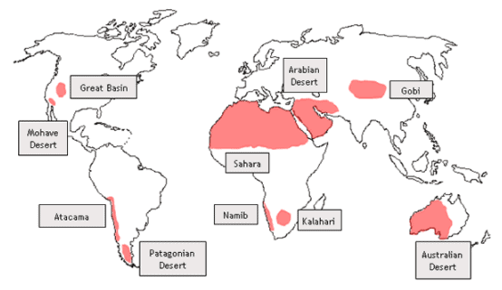
- Important hot deserts of the world are situated on the western edges of the continents between latitudes 15 to 30 degrees north and south.
- Sahara desert is the largest of hot deserts, covering an area of 3.5 million square miles. Other prominent hot deserts include the Great Australian Desert, Arabian desert, Kalahari desert, Thar desert etc.
- Hot deserts are also found in the Americas. In North America, they are known by the names of Mohave, Sonoran, Californian, and Mexican deserts. They extend between USA and Mexico. In South America, the Atacama desert, or the Peruvian desert is located.
Hot deserts – Temperature
- Hot deserts are among the warmest places on Earth, with consistently high temperatures throughout the year. These areas do not experience a distinct cold season, and the average summer temperatures consistently exceed 30 degrees Celsius. The highest recorded temperature in a hot desert was in Libya in 1922, reaching a scorching 57 degrees Celsius.
- The extreme heat in hot deserts can be attributed to several factors, including cloudless skies, intense sunlight, dry air, and a high rate of evaporation. However, the coastal regions of these deserts tend to have a more moderate climate due to the influence of nearby seas and the cooling effect of cold ocean currents, which help to lower the average temperatures in these areas.
- In contrast, the interior regions of hot deserts experience more extreme temperature fluctuations, with sweltering summers and frigid winters. The difference in temperature between day and night, known as the diurnal temperature range, is particularly pronounced in these areas. The intense solar radiation during daytime, combined with dry air and a lack of cloud cover, causes temperatures to soar as the sun rises. Conversely, as the sun sets, temperatures quickly drop below the average due to the continuous loss of heat through radiation and the absence of clouds to retain warmth. As a result, the average diurnal temperature range in hot deserts is around 14 to 25 degrees Celsius.
- Additionally, during winter nights, it is common for frost to form in hot deserts, despite the generally high temperatures associated with these environments.
Hot deserts – Precipitation
- In hot deserts, the average annual precipitation is less than 25 cm, making these regions extremely dry. These deserts are found within the Sub-Tropical High-Pressure Belts, also called the Horse Latitudes, which have descending air masses that create unfavorable conditions for cloud formation and precipitation.
- The Trade Winds, which blow away from the shore, prevent moisture-laden winds from reaching these regions from the sea. Moreover, the Westerlies, which blow towards the shore, do not pass over desert areas, further reducing the likelihood of precipitation.
- The winds that do blow over deserts come from colder regions, which results in a lower relative humidity as they pass over the desert. This decreases the possibility of water vapor condensation and subsequent precipitation. In addition, the relative humidity decreases from 60 percent in coastal areas to less than 30 percent in the interiors, increasing evaporation rates and diminishing any chances of precipitation, thus making these deserts areas of constant drought.
- Cold currents that flow along the west coasts of continents also contribute to the dry nature of these deserts. Moisture-laden winds from the sea often condense into mist or fog when they encounter these cold currents, leaving only dry winds to blow over the deserts.
- However, some convectional rainfall can occur in these regions as brief, intense thunderstorms. These sudden downpours can sometimes lead to disastrous landslides. The Atacama Desert is the world's driest region, with an annual precipitation of less than 2 cm.
Mid-Latitude deserts – distribution
- These desert are often situated on plateaux and are a part of continental interiors.
- They include Gobi desert, Turkestan desert, Patagonian desert etc.
- In India, Ladakh desert falls under this category.
Mid-latitude deserts – climate
- Mid-latitude deserts share several climatic similarities with hot deserts. These deserts are typically located far from the coast or surrounded by tall mountains, which prevents them from receiving moisture-rich winds from nearby seas. As a result, the average annual precipitation in these areas does not exceed 25 cm.
- Occasionally, depressions may reach these deserts in Asia, leading to light rainfall during winter months. Additionally, convectional rainfall can occur during summer months.
- One key difference between mid-latitude and hot deserts is that the former experiences a much wider range of annual temperatures, largely due to the phenomenon of continentality. Continentality refers to the climatic influence of being located on a large landmass, particularly at a significant distance from the coast.
- In mid-latitude deserts, winters can be characterized by freezing temperatures and strong, cold winds. During the summer months, ice may thaw, sometimes causing floods in certain areas. Overall, the extreme temperature fluctuations in these deserts can be attributed to their inland location and the influence of continentality.
Desert Vegetation
- Desert environments contain various forms of plant life, such as grasses, shrubs, and weeds. These plants may not always appear green, as they often remain dormant until they receive water from infrequent rainfall. The most prevalent type of plant life in both hot and mid-latitude deserts is xerophytic, or drought-resistant, scrub.
- Some key species of xerophytic vegetation include bulbous cacti, long-rooted wiry grasses, thorny bushes, and dwarf acacia. In certain areas with an abundance of groundwater, one can find clusters of date palms, particularly in hot deserts. The plant life that thrives in these arid regions is specially adapted to handle extreme dryness.
- Soil in these areas is typically low in humus content due to the lack of moisture which slows down the decomposition of organic matter. Desert shrub vegetation often has an extensive system of long roots that grow in search of groundwater. These plants possess few, if any leaves, and their foliage is often hairy, waxy, or needle-shaped to minimize water loss through transpiration.
- The seeds of desert plants have unique protective mechanisms while they remain dormant, such as thick, tough outer surfaces. When these seeds come into contact with water from rain, they quickly germinate.
Life in the deserts
Although deserts are known for their harsh conditions, various types of human settlements have managed to adapt and thrive in these environments:
- Primitive hunters and gatherers: These are indigenous tribes that do not engage in agriculture or animal domestication. Examples of such tribes include the Bushmen of the Kalahari Desert and the Bindibu, or Aboriginal people of Australia.
- Nomadic herdsmen: These groups rely on a livestock-based economy, traversing the deserts with their herds in search of water and grazing areas. Notable examples include the Bedouins of Arabia, the Tuaregs of the Sahara, and the Mongols of the Gobi Desert.
- Settled cultivators: These communities have established themselves near rivers, such as the Nile in Egypt, Indus in Pakistan, Colorado in the USA, and Tigris-Euphrates in Iraq. They grow crops like wheat, barley, sugarcane, fruits, and vegetables to sustain themselves.
- Mining settlers: These settlements are often centered around the extraction of valuable resources, such as gold mines in Australia, diamond mines in the Kalahari, copper mines in Chile, silver mines in Mexico, and oil in the Persian Gulf countries.
Despite the challenges posed by the desert environment, these diverse groups of people have found ways to adapt and survive in their respective regions.
Steppe Climate
- The term steppe refers to a region which is a semi-desert with a grassland or shrub vegetation.
- Steppes are intermediate regions, not receiving enough rainfall to support a forest but are also not as dry as a desert.
- Steppe Climatic region is also known as Temperate Grasslands.
- These grasslands are some of the most developed agricultural fields and are termed as grain baskets.
- Livestock ranching is another major activity carried out in these areas due to the availability of natural grasses.
Distribution
- Steppes are found in the continental interiors.
- They are usually found in the temperate latitudes and hence come under the influence of Westerly winds.
- Steppes are characterized by vast grasslands which are, by and large, devoid of trees.
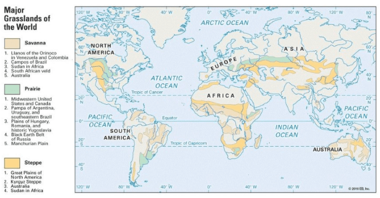
- Steppes typically refer to the vast temperate grasslands of Eurasia, which stretch between the Black Sea coast on the east to the Altai mountains in the west, covering a length of over 2000 miles.
- Steppes are known by their regional names in different parts of the world. They include,
- Prairies – North America
- Pustaz – Hungary
- Pampas – Argentina and Uruguay
- Velds (High Veld) – South Africa
- Downs – Australia
- Canterbury – New Zealand
Precipitation
- The average annual rainfall over the steppes varies from 25 to 75 cm, depending upon the region.
- The highest rainfall occurs in the spring season, or just prior to the onset of summers. In the northern hemisphere, it occurs in the months of June and July.
- During the winters, Westerlies bring in occasional depressions which often cause snowfall over these regions. However, the overall precipitation in the winters is low, at an average of 25 cm.
- In the southern hemisphere, due to a larger influence of maritime weather, higher rainfall occurs over these regions as compared to their counterparts in the northern hemisphere.
Temperature
- These regions are under the effect of continentality and hence experience extremities in temperature.
- Summers are warm with the average temperature in the range of 18-20 degrees centigrade.
- Winters are usually cold with occasional snowfall.
- The steppes in the northern hemisphere have a very high annual range of temperatures.
- To its contrast, the steppes in the southern hemisphere, due to maritime influence, have a moderate climate throughout the year.
Winds
- The dominant winds in these regions are the Westerlies, which bring precipitation during the winter months. In addition to these, numerous local winds significantly influence the area's weather conditions. These winds have various names, such as the cold, dry Mistral in France; the warm, dry Loo in the Gangetic plains; the Sirocco in the Sahara; and the Foehn in the Alps.
- The Chinook is a local, hot, and dry wind that blows across the North American Prairies. As a katabatic wind, it descends from the Rocky Mountains and flows in a southwesterly direction. This wind causes a rapid increase in temperature, often raising it by more than 5 degrees Celsius within just 20 minutes.
- The Chinook wind is beneficial to local agriculture as it helps melt snow on the pastures, making it easier for animals to graze. Overall, these various local winds play a crucial role in shaping the weather patterns and climate of their respective regions.
Vegetation
- In contrast with the tropical grasslands of savanna, which are interspersed with trees, temperate grasslands are practically treeless. Also, the grass in these grasslands is much shorter as compared to that in savanna
- However, the grass is fresh and nutritious, unlike the coarse grass found in the savannas. This is mostly true for the prairies of North America, and also the Chernozem grasses of Ukraine. The prairie soils are also nutritious black earth soils.
- The grass is lean, thin and scattered.
- This makes them ideal for large-scale livestock rearing, also known as ranching.
- The grass growing season is throughout the year, uninterrupted by seasonal variations in temperature and precipitation
- Towards the poleward extension of prairies, there is a transitional zone of forests in which conifers can be found.
- Within the farmlands of steppes, trees are planted around the croplands to shield them from strong winds.
Economy
- Grasslands, such as savannas, steppes, prairies, and pampas, have diverse economic activities depending on their location and resources. While savannas are home to some of the largest terrestrial animals, steppes have less animal diversity. In the Eurasian steppes, horses are commonly found roaming the open landscape.
- Agriculture is a significant economic activity in grasslands, particularly in prairies, due to the development of irrigation canals in the last century. Large-scale mechanized cultivation is practiced in these areas, making them some of the most productive agricultural regions globally. Prairies are often referred to as the world's granaries due to their extensive wheat and maize production.
- Other grasslands, such as the Pampas of Argentina and the Downs of Australia, are also known for their wheat cultivation. The mostly level terrain of the steppes makes plowing and harvesting more manageable, especially with the aid of machinery.
- Livestock ranching is another vital economic activity in grasslands. The less nutritious tufted grass has been replaced with more nutritious Lucerne or alfalfa grass, facilitating large-scale cattle and sheep rearing. As a result, these regions have become global leaders in animal ranching. Grasslands are also the largest producers of dairy and other animal products, such as milk, butter, cheese, beef, and animal skins. These products are exported worldwide, aided by easy access to containerized cargo and refrigerated ships.
- In the vast Eurasian steppes, nomadic herding is practiced by native tribes such as the Kazakhs and Kirghiz. Long periods of drought due to unreliable rains in the continental interiors have made crop cultivation and settled animal rearing almost impossible in these areas. However, in some regions where water is available, large-scale collective farming has been introduced by Russia.
Different grassland regions are known for specific economic activities, including:
- Prairies: Wheat cultivation and livestock ranching.
- Velds: Sheep and cattle rearing, maize cultivation.
- Pustaz: Wheat and beet sugar cultivation.
- Pampas: Wheat cultivation, dairy and beef product exports.
- Downs and Canterbury: Wool production from Merino sheep, dairy products.
Conclusion
Climate refers to the long-term atmospheric conditions in a specific location, encompassing various elements such as temperature, humidity, precipitation, atmospheric pressure, and wind patterns. The world's diverse climates give rise to unique ecosystems and human settlements, each adapted to their specific environments. From hot, wet equatorial forests to the arid desert landscapes and temperate grasslands, these climatic regions are home to distinct vegetation, wildlife, and economic activities. Understanding the complex interactions between various meteorological variables and their effects on the world's climates is crucial for predicting and mitigating the potential impacts of climate change.Frequently Asked Questions (FAQs) of Weather & Climate
What is the difference between weather and climate?
Weather refers to the short-term state of the atmosphere in a specific location, including factors such as temperature, humidity, precipitation, air pressure, wind, and cloud cover. Climate, on the other hand, refers to the long-term synthesis of weather conditions that have occurred in a particular area over an extended period, typically 30 years, providing an overview of the average weather patterns in a specific region.
What are the primary factors that contribute to a region's climate?
The primary factors that contribute to climate include sunlight exposure, temperature fluctuations, levels of humidity, different forms of precipitation (such as rain or snow) and their frequency, atmospheric pressure, and wind patterns in terms of speed and direction.
How are climatic regions classified, and what are some examples of different climatic regions?
Climatic regions are classified based on the combination of meteorological variables such as temperature, precipitation, and wind patterns. Some examples of different climatic regions include hot, wet equatorial climate; savanna or Sudan climate (tropical wet and dry climate); tropical monsoon climate; desert climate; and steppe climate.
How do the vegetation and wildlife differ between savanna and steppe climates?
Savanna climates are characterized by tall grasses and short trees, often referred to as 'bush-veld' or 'parkland'. The wildlife in savanna ecosystems includes large herbivores such as zebras, giraffes, elephants, and antelopes, as well as carnivores such as lions, hyenas, leopards, and panthers. In contrast, steppe climates are characterized by shorter grasses and are practically treeless. The wildlife in steppe ecosystems is less diverse than in savannas, but these areas are ideal for large-scale livestock rearing or ranching.
How do human settlements adapt and survive in desert climates?
Human settlements in desert climates adapt and survive through various means, such as engaging in subsistence agriculture, nomadic pastoralism, settled cultivation near rivers, or mining settlements focused on the extraction of valuable resources. Despite the challenges posed by the desert environment, these diverse groups of people have found ways to adapt and thrive in their respective regions.
|
303 videos|636 docs|252 tests
|
FAQs on Weather & Climate - Geography Optional for UPSC
| 1. What is a hot, wet equatorial climate? |  |
| 2. What are the main features of a hot, wet equatorial climate? |  |
| 3. What are the factors that influence a hot, wet equatorial climate? |  |
| 4. What are the effects of a hot, wet equatorial climate on vegetation and biodiversity? |  |
| 5. How does a hot, wet equatorial climate impact human activities and settlements? |  |


