Waves, Currents & Tides | Geography Optional for UPSC (Notes) PDF Download
| Table of contents |

|
| Ocean Waves |

|
| Tides |

|
| Ocean Currents |

|
| Causes of Ocean Currents |

|
| Desert Formation and Ocean Currents |

|
| Frequently Asked Questions (FAQs) of Waves, Currents & Tides |

|
Ocean Waves
- A wave is a rhythmic movement that transfers energy through matter or space. In the context of ocean waves, this refers to the undulating motion of the water's surface.
- Waves are characterized by oscillatory movements that cause the water surface to rise and fall. They are a form of horizontal motion in ocean water. However, it is important to note that it is the energy, rather than the water itself, that moves across the ocean's surface. This energy is primarily supplied by the wind.
- As a wave progresses, each water particle moves in a circular pattern. There are two main components to a wave: the elevated part, known as the crest, and the low point, referred to as the trough.
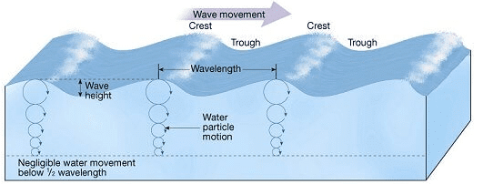
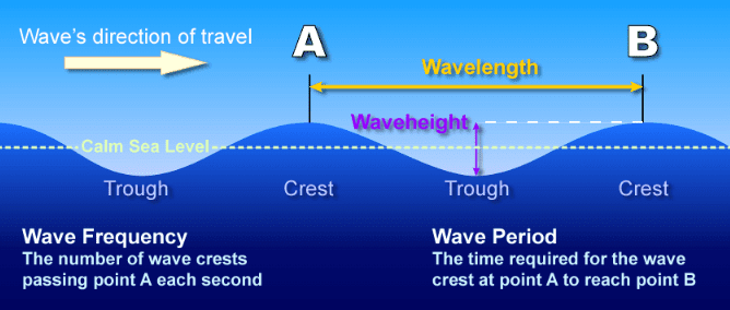 Ocean Wave Description
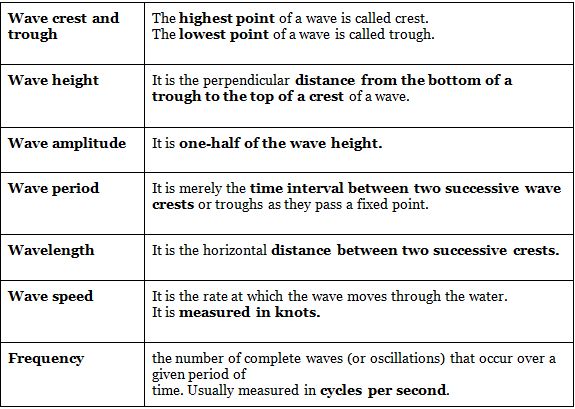
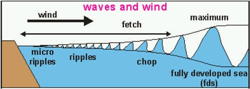
Most of the waves present on the ocean’s surface are wind-generated waves.
Friction from the wind moving over the water causes the water to move along with the wind. If the wind speed is high enough, the water begins to pile up and a wave is formed.
As wind velocity increases: Wavelength, Wave period, Height Increase.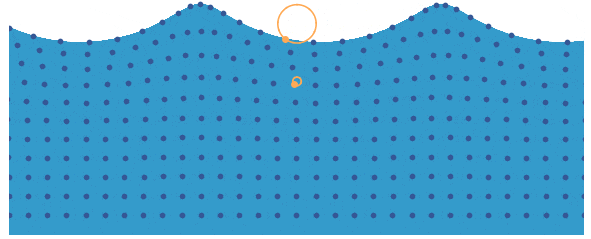 Wave Motion
The diameter of the orbit: increases with increasing wave size.
The diameter of the orbit: decreases with depth below the water surface.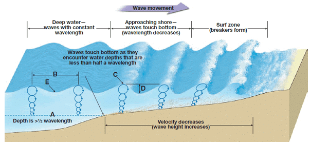 Wave Motion and Diameter
As the wave slows, its crest and trough come closer together. The top of the wave is not slowed by friction and moves faster than the bottom.
Wave Types
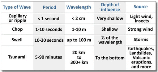 Ocean Wave Types
 Waves And WindWave Cut action
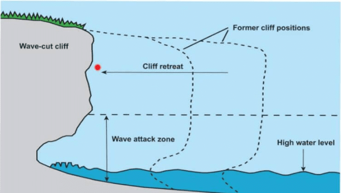 Wave Cut Action
Tides
- Tides refer to the periodic short-term fluctuations in sea levels, primarily caused by the gravitational interactions between the Earth, Moon, and Sun. The Moon, being closer to the Earth, has a more significant influence on tides than the Sun. The Earth's rotation also contributes to the formation of tides.
- The primary causes of tides are the gravitational pulls from the Moon and, to a lesser extent, the Sun. Additionally, a centrifugal force that acts in opposition to the Earth's gravitational pull also affects tides. The balance between these forces results in the formation of tides.
- High tides occur when the crest, or the highest part of a wave, reaches a specific location, while low tides correspond to the trough, or the lowest part of the wave. The tidal range represents the difference in height between high and low tides.
- The world's highest tide occurs in the Bay of Fundy (Canada). In India, the highest tide is recorded at Okha, Gujarat. The largest tidal range globally is found at the upper end of the Bay of Fundy in eastern Canada, where it is common to observe water level fluctuations of up to 15 meters (50 feet) twice a day. This phenomenon also results in a tidal bore—a wall of seawater ranging from several centimeters to over a meter in height—that rushes up the Petitcodiac River in New Brunswick, covering many kilometers.
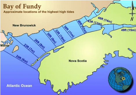 Bay of Funday
Tide changes proceed via the following stages:
- Sea level rises over several hours, covering the intertidal zone; flood tide.
- The water rises to its highest level, reaching high tide.
- Sea level falls over several hours, revealing the intertidal zone; ebb tide.
- The water stops falling, reaching low tide.
Tidal streams refer to the oscillating currents created by the changing tides. When the tidal current comes to a halt, it is known as slack water or slack tide. At this point, the tide changes direction, which is referred to as "turning." Slack water typically takes place close to high and low water times. However, in some locations, the timing of slack tide may differ from high and low water.
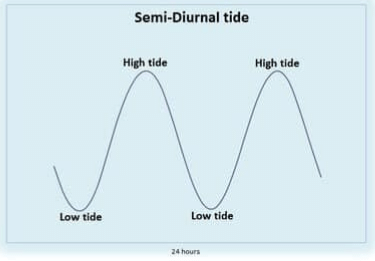
Tides usually have a semi-diurnal cycle (two high tides and two low tides per day) or a diurnal cycle (one complete tidal cycle per day). On any given day, the two high tides may not be of equal height, which is referred to as the daily inequality. As a result, tide tables indicate a higher high water and a lower high water level. Similarly, the two daily low tides consist of a higher low water and a lower low water level. The daily inequality varies and is generally minimal when the Moon is positioned above the equator.
Types of Tides
Tides vary in their frequency, direction and movement from place to place and also from time to time.
Tides may be grouped into various types based on their frequency of occurrence in one day or 24 hours or based on their height.
Tides based on Frequency
- Semi-diurnal tide
- Diurnal tide
- Mixed tide
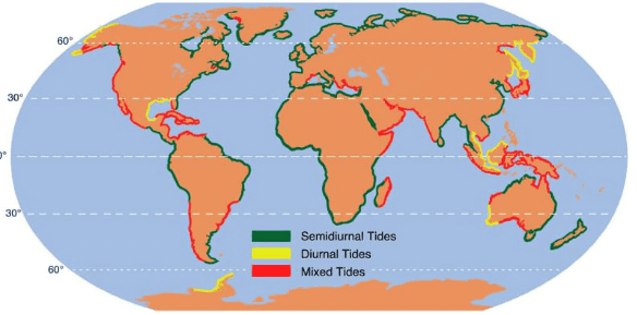
Semi-Diurnal Tide
- The most common tidal pattern consists of two high tides and two low tides each day, with variations ranging from 3 to 4 tides in certain cases. Typically, the heights of consecutive high or low tides are roughly the same.
- Tides occur at regular intervals of 12 hours and 25 minutes, rather than exactly 12 hours. This is due to the moon's orbit around the Earth, as it moves from west to east. The moon's position relative to the Earth shifts slightly to the east each day when observed from the same location at the same time. This time lag is responsible for the 12-hour and 25-minute interval between tides, which occur twice daily.
- In Southampton, England, tides occur 6-8 times per day. This is due to the combined effects of the North Sea and English Channel, which push water at different intervals. Southampton experiences 2 high tides from the North Sea, 2 high tides from the English Channel, 2 neap tides from the North Sea, and 2 neap tides from the English Channel.
Diurnal Tide
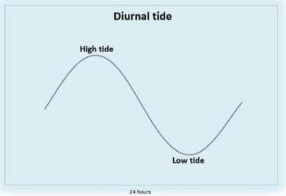
- Each day, there is a single high tide and a single low tide, with both of these tides having roughly the same height. Essentially, the ocean level rises once and falls once in a 24-hour period, with the difference in water levels remaining fairly consistent.
Mixed Tide
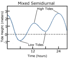
- Mixed tides refer to the fluctuations in tidal heights, often seen along the western coast of North America and numerous islands in the Pacific Ocean. These variations in tidal height make the tides appear irregular, resulting in a combination of higher and lower tides.
Tides based on the Sun, Moon and the Earth Positions
The height of rising water (high tide) varies appreciably depending upon the position of the sun and moon with respect to the earth. Spring tides and neap tides come under this category.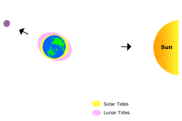
Spring Tides
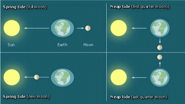
- The height of tides on Earth is influenced by the positions of the sun and the moon relative to our planet. When these three celestial bodies align in a straight line, known as a syzygy, the resulting tides are higher than usual.
- These heightened tides, called spring tides, occur twice a month - once during the full moon phase and again during the new moon phase.
Neap Tides
- Neap tides occur when the Moon is in its first or third quarter phase, causing the Sun and Moon to be separated by 90° when observed from Earth. During this time, the Sun's tidal force partially counteracts the Moon's tidal force. Although the Moon's gravitational pull is more than twice as strong as the Sun's, its influence is reduced due to the opposing force of the Sun's gravity.
- The term "neap" is derived from an Anglo-Saxon word meaning "without power," which is fitting as the tidal range is at its minimum during this period. Neap tides, also known as "neaps," typically occur twice a month, with a seven-day interval between spring tides and neap tides.
The Magnitude of Tides based on Perigee and Apogee of Moon
- Once in a month, when the moon’s orbit is closest to the earth (perigee), unusually high and low tides occur. During this time the tidal range is greater than normal.
- Two weeks later, when the moon is farthest from earth (apogee), the moon’s gravitational force is limited and the tidal ranges are less than their average heights.
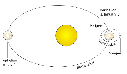
Magnitude of tides based on Perigee and Apogee of earth
- The magnitude of tides is influenced by the Earth's proximity to the sun and the moon. When the Earth is closest to the sun, known as perihelion, which occurs around January 3rd each year, the tidal ranges are much greater, resulting in unusually high and low tides. On the other hand, when the Earth is farthest from the sun, called aphelion, which occurs around July 4th each year, the tidal ranges are smaller than average. Apogee refers to the point in an orbit around the Earth that is furthest from the Earth, while aphelion is the point in the elliptical orbit of a celestial body where it is farthest from the sun.
- Tides are important for various reasons, particularly because they can be accurately predicted due to the known positions of the Earth, moon, and sun. This allows navigators and fishermen to plan their activities accordingly.
- Navigation is significantly impacted by tidal heights. Harbors situated near rivers and within estuaries with shallow bars at their entrances require high tides for ships and boats to enter safely. High tides raise the water level near the shore, making it easier for ships to arrive at the harbor.
- Additionally, tides can make certain rivers navigable for ocean-going vessels, contributing to the development of important ports. For example, the tidal nature of the Thames and Hooghly rivers has allowed London and Kolkata (formerly Calcutta) to become significant ports. In summary, the Earth's position relative to the sun and the moon affects the magnitude of tides, which play a crucial role in navigation and the establishment of key ports.
Fishing
- The high tides also help in fishing. Many more fish come closer to the shore during the high tide. This enables fishermen to get a plentiful catch.
Desilting
- Tides are also helpful in desilting the sediments and in removing polluted water from river estuaries.
Other
- Tides are used to generate electrical power (in Canada, France, Russia, and China).
- A 3 MW tidal power project was constructed at Durgaduani in Sunderbans of West Bengal.
Characteristics of Tides
Tides are characterized by various factors, such as their height, strength, and intensity, which are influenced by geographical features and locations.
- On broad continental shelves, tidal bulges tend to be higher due to the shape and size of the shelf. In contrast, tidal currents are generally weaker in the open ocean, where there is less resistance from landforms.
- When tidal bulges reach mid-oceanic islands, their height tends to decrease due to the smaller area and less resistance offered by the island. The shape of bays and estuaries along coastlines can also affect the intensity of tides, with many resulting in stronger tides.
- Funnel-shaped bays, in particular, can greatly alter tidal magnitudes. The Bay of Fundy is a prime example of this, as it has the highest tidal range in the world. However, the large continents on Earth obstruct the westward movement of tidal bulges as the planet rotates, causing variations in tidal patterns.
- As a result of these factors, tides differ significantly between oceans and locations, making them complex and diverse phenomena.
Tidal bore
- A tidal bore is a large wave that occurs when the spring tide enters a long, narrow, and shallow inlet. The wave is generated due to the constriction of the tidal forces and turbulence in the whelps, resulting in a rumbling roar. High tides can also happen in gulfs, particularly in those with wide fronts and narrow rears.
- The movement of water into and out of a gulf through channels is referred to as a tidal current. When a tidal wave enters the narrow and shallow estuary of a river, the front of the wave appears vertical because the river water piles up against the tidal wave, and the friction of the river bed is present. This steep-nosed tidal crest looks like a vertical wall of water rushing upstream and is called a tidal bore.
- Several factors contribute to the formation of tidal bores, including the strength of the incoming tidal wave, the width and depth of the channel, and the river flow. However, there are exceptions, such as the Amazon River, which is not narrow but still experiences a strong tidal bore due to its shallow mouth with numerous low-lying islands and sandbars.
- In India, tidal bores are commonly observed in the Hooghly River, while the most powerful tidal bores occur in the Qiantang River in China. The term "bore" comes from the sound the tidal current makes when traveling through narrow channels.
- Tidal bores occur in relatively few locations worldwide, typically in areas with a large tidal range of more than 6 meters (20 ft) between high and low water. These bores usually happen during the flood tide and seldom during the ebb tide. Additionally, tidal bores almost never occur during neap tides, which are the weakest tides that take place during the quarter moon phases.
Impact of Tidal Bore
- The impact of tidal bores can be significant and varies in different aspects. While tides are stable and predictable, tidal bores are less so, making them potentially dangerous.
- In terms of shipping and navigation, tidal bores can pose challenges in estuarine zones. Bores of considerable magnitude have the potential to capsize boats and large ships, causing disruptions to maritime activities.
- Fishing zones in estuaries and gulfs can also be negatively affected by strong tidal bores. These areas, which are crucial for the sustenance of various wildlife species, can experience disruptions in their ecological balance.
- The environment near the river mouth can be adversely impacted by tidal bores as well. Estuaries influenced by tidal bores serve as essential feeding and breeding grounds for numerous forms of wildlife. When these bores occur, animals can be caught in the leading edge of the tidal wave and become buried in the silty water. As a result, carnivores and scavengers are often seen following tidal bores, contributing to the ecological impact.
- In summary, tidal bores can have negative effects on shipping, navigation, fishing, and the ecology of river mouths and estuaries. These unpredictable events can be dangerous and disruptive for both human activities and the natural environment.
Ocean Currents
- Ocean currents refer to the continuous, general movement of ocean water in a specific direction, similar to a river flowing over the ocean's surface. Approximately 10% of the world's ocean water is involved in surface currents, which primarily move water horizontally and vertically in the top layer above the thermocline, the layer where temperature changes rapidly. The water below the thermocline also circulates, but the movement is much slower.
- The heat budget of the Earth varies across latitudes, with a surplus of heat in the tropics and a deficit in the polar regions (beyond 40 degrees N and S). Weather phenomena and circulation patterns help to transfer heat from the tropics towards the poles, maintaining the Earth's heat balance. Ocean currents play a significant role in this process.
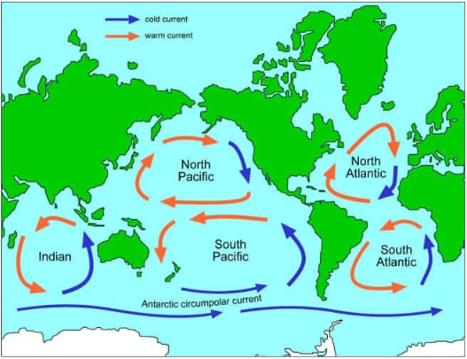
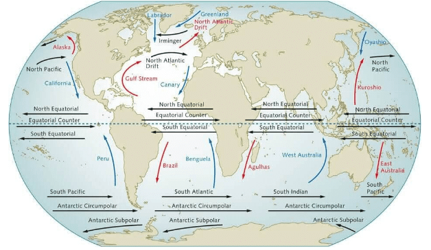
- Ocean currents can be classified as warm or cold currents, depending on their impact on the destination region rather than their absolute temperature. A warm current is one that moves towards the poles in both hemispheres, carrying warm water from lower latitudes to higher latitudes. In contrast, a cold current originates from higher latitudes and moves towards the tropics, bringing cooler water to those regions.
 In prelims, a question can be asked on the character of the ocean currents. Ocean currents will be numbered as 1,2,3 and 4 and it will be asked whether they are cold or warm, or which of them are cold/warm. Now you don’t need to know the name of those currents, they can be hypothetical also, just by seeing the direction of the flow of ocean currents; you will be able to answer that.
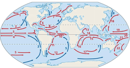
- In the above map, if you see, current (1) and (6) are in the same latitudes but because of their direction of motion, they are categorized as cold and warm.
Note: There are some exceptions to this general rule. Kindly check the important ocean currents from a World Map.
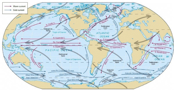
Types of Ocean Currents
1. Based on Depth
The ocean currents may be classified based on their depth as surface currents and deep water currents:
- surface currents constitute about 10 percent of all the water in the ocean, these waters are the upper 400 m of the ocean;
- deep water currents make up the other 90 percent of the ocean water. These waters move around the ocean basins due to variations in density and gravity.
(i) The density difference is a function of different temperatures and salinity
(ii) These deep waters sink into the deep ocean basins at high latitudes where the temperatures are cold enough to cause the density to increase.
2. Based on Temperature
Ocean currents are classified based on temperature: as cold currents and warm currents:
- Cold currents bring cold water into warm water areas [from high latitudes to low latitudes]. These currents are usually found on the west coast of the continents (currents flow in the clockwise direction in the northern hemisphere and in anti-clockwise direction in the southern hemisphere) in the low and middle latitudes (true in both hemispheres) and on the east coast in the higher latitudes in the Northern Hemisphere;
- Warm currents bring warm water into cold water areas[low to high latitudes] and are usually observed on the east coast of continents in the low and middle latitudes (true in both hemispheres). In the northern hemisphere, they are found on the west coasts of continents in high latitudes.
Forces Responsible For Ocean Currents
1. Primary Forces
Influence of insolation
- Heating by solar energy causes the water to expand. That is why, near the equator the ocean water is about 8 cm higher in level than in the middle latitudes.
- This causes a very slight gradient and water tends to flow down the slope. The flow is normally from east to west.
Influence of wind (atmospheric circulation)
- The influence of wind on atmospheric circulation plays a significant role in the movement of ocean waters. When wind blows across the ocean surface, it causes the water to move due to the friction between the wind and the water surface. The force and direction of the wind, combined with the Coriolis effect, determine the magnitude and direction of ocean currents. A prime example of this is the seasonal reversal of ocean currents in the Indian Ocean, which is caused by monsoon winds.
- The patterns of oceanic circulation generally correspond to those of Earth's atmospheric circulation. In the middle latitudes, air circulation over the oceans is predominantly anticyclonic, meaning that it revolves around a high-pressure center. This pattern is more pronounced in the Southern Hemisphere than in the Northern Hemisphere due to differences in the extent of landmass. Consequently, oceanic circulation patterns in these regions also follow this anticyclonic pattern.
- In higher latitudes, wind flow is primarily cyclonic, which means that it revolves around a low-pressure center. This pattern is found in the sub-polar low-pressure belt, and oceanic circulation in these areas also reflects this cyclonic pattern.
- In regions with prominent monsoonal flows, such as the northern Indian Ocean, monsoon winds greatly influence the movement of ocean currents. These currents change direction according to the seasonal shifts in wind patterns. Overall, wind plays a crucial role in shaping the circulation patterns of both the atmosphere and the oceans.
Influence of Gravity
- Gravity tends to pull the water down to pile and create gradient variation.
Influence of Coriolis Force
- The Coriolis force intervenes and causes the water to move to the right in the northern hemisphere and to the left in the southern hemisphere.
- These large accumulations of water and the flow around them are called Gyres. These produce large circular currents in all the ocean basins. One such circular current is the Sargasso Sea.
2. Secondary Forces
- Secondary forces, such as temperature and salinity differences, play a significant role in shaping ocean currents. These differences in water density greatly influence the vertical movement of currents, known as vertical currents.
- The density of water is affected by its salinity and temperature. Highly saline water is denser than water with low salinity, and cold water is denser than warm water. As a result, dense water tends to sink, whereas lighter water tends to rise.
- Cold-water ocean currents develop when the dense, cold water near the poles sinks and gradually moves toward the equator. In contrast, warm-water currents originate at the equator, where the lighter, warm water flows along the surface towards the poles, replacing the sinking cold water.
- In summary, temperature and salinity differences in ocean water create density variations that drive the vertical movement of ocean currents. Cold-water currents form when dense, cold water sinks and moves from the poles to the equator, while warm-water currents flow from the equator towards the poles, replacing the sinking cold water.
Important Ocean Currents
It is important for you to remember cold and warn ocean currents.
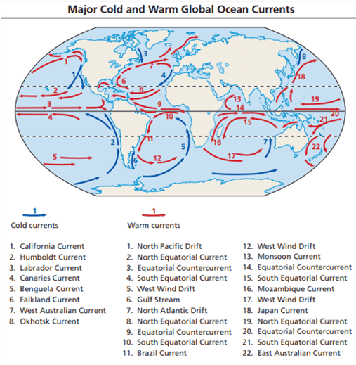
NOTE- Major Fishing grounds of the World exist where warm and cold Ocean Current meets.
Causes of Ocean Currents
1. Planetary WindsPlanetary winds play a vital role in the formation and sustenance of ocean currents. Since planetary winds blow with consistency, over the surface of the ocean, they tend to push the water in one direction because of friction. This is the main cause of the flow of water.
Because of the Coriolis Effect, in the Northern Hemisphere currents flow to the right of the wind direction while in the Southern Hemisphere, winds blow to the left. Intervening continents and basin topography often block the continuous flow of the water and often deflect the moving water in a circular pattern. This circular motion of water along the periphery of the ocean basin is called Gyre. The following Map will broadly show the formation of different gyres in Oceans.
2. Effect of the Temperature
There are marked variations in the horizontal and vertical distribution of the temperatures in the ocean. In general, the temperature decreases as we move towards the pole from the equator.
There is an inverse relationship between temperature and density of the water i.e. higher the temperature, the lower will be its density. As a result, the warm and low-density water from the equatorial region moves towards the colder polar waters. Contrary to this there is a movement of ocean water below the water surface in the form of subsurface current from colder polar areas to warmer equatorial area. The Gulf Stream and Kuroshio Current (warm) are very good examples of this.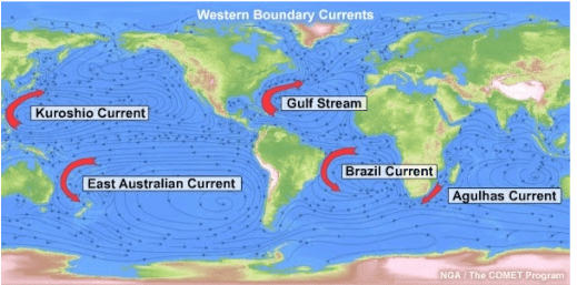
3. Salinity
- The salinity levels in the ocean can differ depending on the location. Water that has a higher salinity is denser compared to water with lower salinity. This difference in density leads to the creation of ocean currents, which typically flow from areas of low salinity to areas of high salinity.
- For instance, ocean currents can be observed moving from the open ocean towards inland seas, such as the current that flows from the Atlantic Ocean into the Mediterranean Sea. Similarly, there is a current that flows from the Indian Ocean into the Red Sea through the Bab Al Mandab strait. The Peru Current is another example of a current that is generated due to variations in water density caused by differences in salinity.
4. Rotation of Earth
- The Coriolis force is a deflective force caused by the Earth's rotation from west to east on its axis. This force influences the direction of ocean currents, causing them to veer towards the right in the Northern Hemisphere and towards the left in the Southern Hemisphere. As a result, ocean currents form a clockwise circulation in the Northern Hemisphere and a counterclockwise circulation in the Southern Hemisphere. These large circular patterns are known as gyres.
- The North Atlantic Gyre is particularly notable because it traps water within its circulating currents, creating a stagnant body of water known as the Sargasso Sea. This sea, named after the Sargassum weed found within it, is unique because it is the only sea located entirely within an ocean. The Sargassum weed is an endemic vegetation found exclusively in the Sargasso Sea, which is an internationally protected area.
5. Configuration of the Coastline
Coastline plays an important role in governing the direction of the flow of the ocean current. For example, the equatorial current after being obstructed by the Brazilian coast is bifurcated into two branches. The Northern Branch is called the Caribbean current while the Southern branch is called the Brazilian current.
Note: After hitting a coastline, apart from moving towards North and South, some of the water also moves downward, this is called Downwelling.
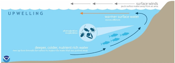
This water penetrates deep in the ocean and moves parallel to the surface current as an undercurrent and comes out on the other side of the ocean as upwelling. Since this upwelling water comes out from the depth, it is relatively cold and brings a lot of nutrients to the surface. Regions, where upwelling is present, are rich fishing grounds e.g. Peru coast.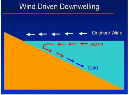
Desert Formation and Ocean Currents
- Major hot deserts are located between 20-30 degree latitudes and on the western side of continents because of the effects of off-shore Trade Winds, which is why they are also called Trade Wind Deserts. These deserts, such as the Sahara, the Great Australian Desert, the Arabian Desert, the Iranian Desert, the Thar Desert, the Kalahari Desert, and the Namib Desert, are situated along the Horse Latitudes or the Sub-Tropical High-Pressure Belts where the air descends, creating conditions that make precipitation unlikely.
- The rain-bearing Trade Winds blow off-shore, and the Westerlies, which blow onshore, remain outside the desert limits. Consequently, the winds that reach the deserts blow from cooler to warmer regions, lowering their relative humidity and making condensation almost impossible. The absence of clouds in the sky and the low relative humidity result in the evaporation of any moisture, creating regions of permanent drought.
- On the western coasts, cold currents produce mists and fogs by chilling the incoming air. As this air warms up when it comes into contact with hot land, little rain falls. The desiccating effect of cold currents, such as the Peruvian Current along the Chilean coast, is so strong that the mean annual rainfall in the Atacama Desert is no more than 1.3 cm.
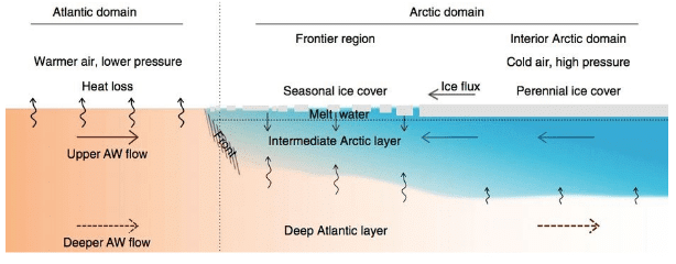
- "Atlantification" is a process where warmer water from the Atlantic Ocean flows into the Arctic at the Barents Sea. This warmer, saltier Atlantic water is typically deeper under the more buoyant Arctic water at the surface. However, the Atlantic water has been rising recently, causing the heat in the Atlantic water to prevent ice formation and melt existing sea ice from below. As a result, the ice is now being affected both from the top by a warming atmosphere and at the bottom by a warming ocean.
Conclusion
Ocean waves, tides, and currents play crucial roles in shaping the Earth's climate, navigation, fishing, and overall marine ecosystem. The interactions between the Earth, Moon, and Sun, as well as factors such as wind, temperature, salinity, and the Earth's rotation, contribute to the formation and characteristics of these oceanic phenomena. Understanding and predicting these oceanic movements are essential for the safety of maritime activities and the conservation of marine life. Moreover, the study of ocean currents and tides provides valuable insights into the Earth's heat budget, climate patterns, and the distribution of nutrients in the ocean, all of which are vital for maintaining the delicate balance of our planet's ecosystems.
 |
Download the notes
Waves, Currents & Tides
|
Download as PDF |
Frequently Asked Questions (FAQs) of Waves, Currents & Tides
What are the primary forces responsible for the formation of ocean currents?
The primary forces responsible for the formation of ocean currents are the influence of insolation (solar radiation), the influence of wind (atmospheric circulation), gravity, and the Coriolis force due to the Earth's rotation.
What is the difference between warm and cold ocean currents?
Warm ocean currents are those that move from lower latitudes (near the equator) towards higher latitudes (towards the poles), carrying warm water to colder regions. Cold ocean currents, on the other hand, originate from higher latitudes and move towards the tropics, bringing cooler water to warmer regions.
What is a tidal bore and where do they occur?
A tidal bore is a large wave that occurs when the spring tide enters a long, narrow, and shallow inlet. The wave is generated due to the constriction of the tidal forces and turbulence in the whelps, resulting in a rumbling roar. Tidal bores occur in relatively few locations worldwide, typically in areas with a large tidal range of more than 6 meters (20 ft) between high and low water.
How do temperature and salinity differences in ocean water affect ocean currents?
Temperature and salinity differences in ocean water create density variations that drive the vertical movement of ocean currents. Cold-water currents form when dense, cold water sinks and moves from the poles to the equator, while warm-water currents flow from the equator towards the poles, replacing the sinking cold water.
What are gyres and how are they formed?
Gyres are large circular patterns of water movement along the periphery of the ocean basins. They are formed due to the deflection of ocean currents by the Earth's rotation (Coriolis force), as well as the presence of intervening continents and basin topography. Gyres produce a clockwise circulation in the Northern Hemisphere and a counterclockwise circulation in the Southern Hemisphere.
|
191 videos|377 docs|117 tests
|
FAQs on Waves, Currents & Tides - Geography Optional for UPSC (Notes)
| 1. What are ocean waves? |  |
| 2. How are tides formed? |  |
| 3. What are ocean currents? |  |
| 4. What are the causes of ocean currents? |  |
| 5. How do ocean currents influence desert formation? |  |

