Erosion Surfaces | Geography Optional for UPSC PDF Download
Erosional Surfaces
Erosion or planation surfaces are the outcomes of denudation processes, which result in undulating ground surfaces and remnants of high relief cutting across geological formations and structures. These surfaces are essential for understanding the development of landforms as well as the past geomorphic processes and evolutionary history of landscapes. They can provide insight into the denudation chronology.
- Various scholars have used different terms to describe planation surfaces, including "peneplain" (Davis), "pediplain" (L.C. King), "panplain" (Crickmay), "etchplain" (Wayland 1934, Thomas), "panfan" (A.C. Lawson), "primarrumpf," "gipfelflur," "stockwerk," "schietelflur," and "stripped surface" (Budel 1957). Some minor erosion surfaces include valley-side beaches (terraces), river terraces, and marine benches (platforms).
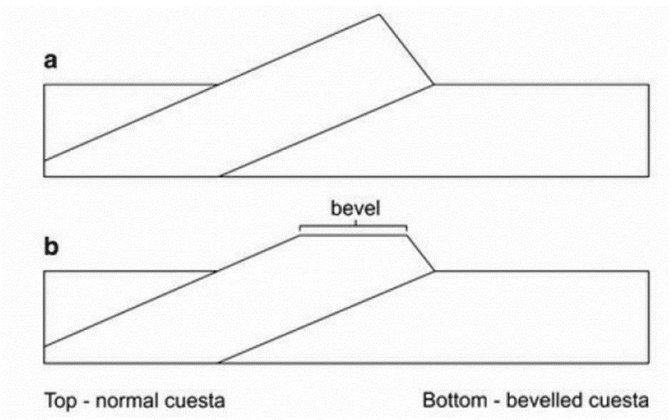
- Although the study of erosion surfaces became less popular during the second half of the 20th century, the current consensus is that they do exist, and interest in them has been revived. Erosional plains are planation surfaces that cut across various bedrock types and geological structures, and they can be found in both low-lying areas and at higher elevations. Elevated plains often show signs of an erosional origin, followed by subsequent dissection, like a bevelled cuesta.
- A cuesta is a hill or ridge with a gentle slope on one side and a steep slope on the other. The flat top or bevel on a cuesta can be seen as evidence of an upper erosion surface that existed before differential erosion shaped the cuesta. However, it is essential to note that a single bevelled cuesta does not necessarily indicate a planation surface. It could also be a river terrace or another small flat feature. A planation surface is more likely when multiple bevelled cuestas occur at about the same elevation.
In summary, planation surfaces, also known as erosional surfaces or paleoplains, are the result of various erosion agents, such as wind, running water, and glaciers, acting in different climatic regions. These geographically plain surfaces or faint reliefs are produced during the final phase of the erosion cycle and are essential for understanding the evolution of landforms and the history of geomorphic processes.
Peneplains
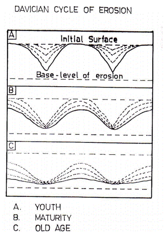
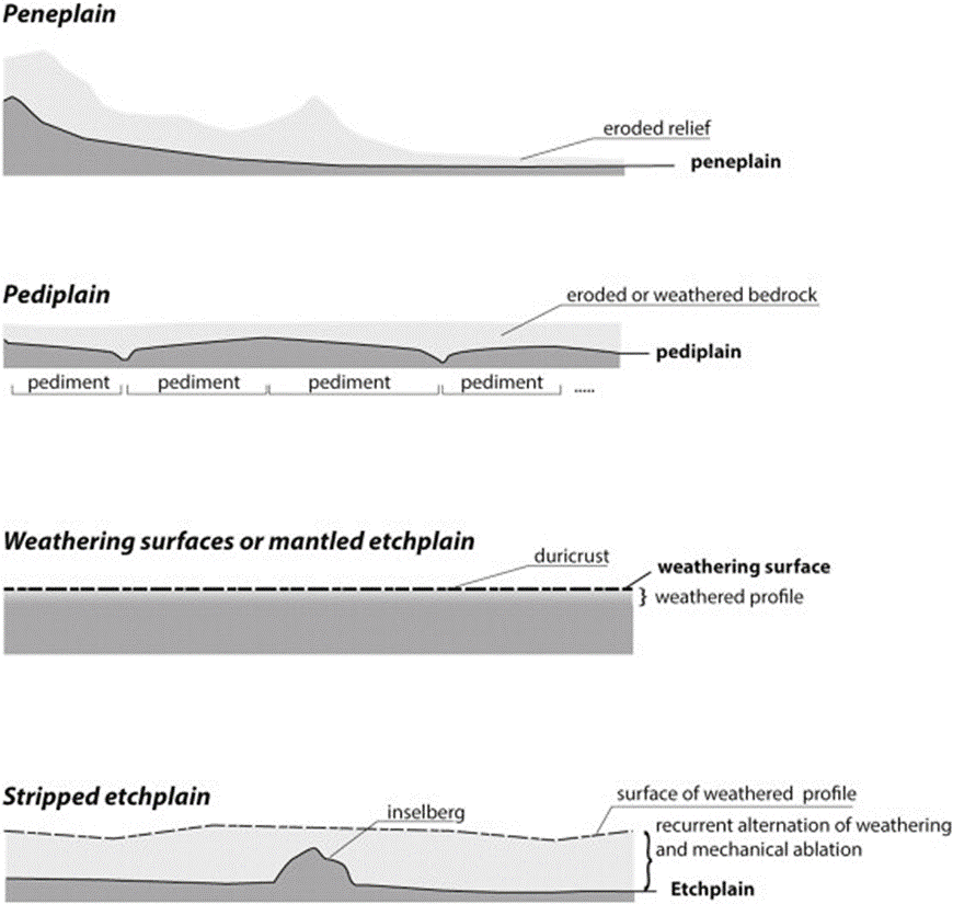
- The concept of a peneplain, which means "almost a plain," was developed from W.M. Davis' cyclic view of landscape evolution. According to Davis, as rivers and hillslopes progress through the stages of youth, maturity, and old age, they gradually reduce the relief of the landscape, ultimately creating a plain with extremely low relief. The rate of change in this plain is minimal due to the reduced potential energy for fluvial action.
- In the youthful stage, valleys are typically V-shaped. As the landscape matures, valleys become flat-bottomed due to the dominance of lateral erosion. In the old age stage, valleys have very shallow features as they become part of extensive plains, with lateral erosion eroding away all hills.
- Young landscapes are characterized by large areas of flat topography, which are remnants of the original uplifted peneplain. As landscapes mature, the valleys deepen and widen, creating V-shaped valleys that consume much of the interfluves, or areas between river systems, which still bear traces of the original land surface. Old landscapes are characterized by peneplains, where the interfluves are reduced to minor undulations, creating a nearly flat landscape.

Pediplains
- The pediplain concept was developed by Lester Charles King, who built upon Penck's model of slope retreat in his own model of landscape evolution. King's idea was that slope retreat creates pediments, and when enough pediments are formed, a pediplain is the result. He envisioned this process occurring in "cycles of pedimentation."
- Each cycle starts with a sudden burst of cymatogenic diastrophism, followed by a period of diastrophic quiescence. During this calm period, subaerial processes reduce the relief to a pediplain. As the continent is eroded, the sediment is deposited offshore. As sediment is removed from the continental margins, they rise, while the weight of the sediment in offshore regions causes depression.
- This simultaneous uplift and depression lead to the formation of a major scarp near the coast, which then cuts back inland. As the scarp retreats, it leaves behind a pediplain, further unloading the continent and placing additional sediment offshore.
- Over time, new cycles of uplift and depression occur, creating new scarps. This cyclical relationship between continental unloading and offshore loading results in landscapes consisting of a large staircase of erosion surfaces or pediplains, with the oldest steps found deep inland.

Endrumpf
- In the landscape evolution model proposed by Walther Penck, the endrumpf refers to the final stage of erosion that occurs after inselbergs (isolated hills or mountains) and their surrounding pediments (gentle slopes) have disappeared. The endrumpf is characterized by a landscape with low-angle, concave slopes that gradually retreat over time.
- Penck's model is a variation on the earlier model proposed by William Morris Davis, who believed that uplift and planation (the process of creating a flat surface) occurred alternately. However, in many landscapes, uplift and denudation (the wearing away of the earth's surface) actually occur simultaneously. This led Penck to develop a different model of landscape evolution, in which the evolution of individual slopes plays a crucial role in determining the overall landscape's development.
- In Penck's model, the continuous and gradual interaction between tectonic processes (such as uplift and earth movement) and denudation results in a unique landscape evolution pattern, where the endrumpf stage is reached after the inselbergs and their surrounding slopes have been eroded away.

Panplains
- Colin Hayter Crickmay (1933, 1975) introduced the concept of unequal activity in slope retreat, which deviates from the models of landscape evolution proposed by Davis, Penck, and King, who assumed that slope processes act evenly on individual slopes. In reality, geomorphic agents do not act uniformly.
- As a result, a slope may only recede in areas where its base is eroded by a stream (or the sea). In this case, slope denudation is primarily achieved through the lateral erosion of rivers (or marine erosion at the base of cliffs), meaning that some parts of the landscape may remain virtually unaffected by slope recession. Crickmay argued that this lateral erosion by rivers leads to the formation of Panplains.
Etchplains and Etched Surfaces
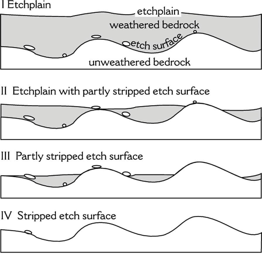
- Landscape evolution was traditionally thought to be primarily influenced by mechanical erosion. However, recent research indicates that chemical weathering plays a significant role in shaping landscapes, especially in tropical and subtropical environments. One such process is etch planation, which involves the formation of a thick regolith through chemical weathering, followed by erosion.
An etchplain, or etched peneplain, is a landscape feature resulting from etch planation. The concept was first introduced by E.J. Wayland and - Bailey Willis in the 1930s and later refined by Julius Budel. Etchplains are mainly formed by chemical weathering, with weakly acidic water lowering the weathering front, similar to how an acid-soaked sponge would etch a metal surface.
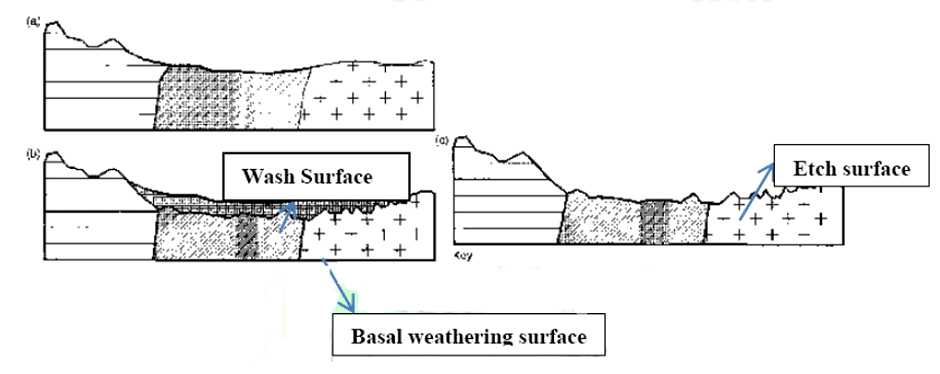
- Some researchers propose the theory of double planation, which suggests that surface erosion and chemical etching occur at the same rate, maintaining land surfaces of low relief during slow uplift. This theory involves two planation surfaces: the wash surface and the basal weathering surface (etch surface).
- There are various types of etchplains, ranging from stripped etchplains to those covered with thick waste. One example is the Chotanagpur region, where the bedrock is mostly hidden beneath a layer of soil and regolith. Laterite beds can be found at the surface, acting as a cap rock and helping to maintain even topography.
- Thomas identified five types of etchplains: undissected lateritized surface, dissected lateralized etchplain, extensively stripped surface, partially stripped erosion surface, and incised erosion surface. However, there may be other variations, such as the one seen in Chotanagpur.
- Etchplains can also form on non-crystalline sedimentary rocks, though some researchers question the distinction between etchplains and pediments. Despite this, the term "etchplain" is still used by some geomorphologists, as it helps to explain landscape features found in warmer climates, now present in temperate latitudes.
Panfan
- Lawson coined the term "Panfan" to describe the final stage of geomorphic development in arid regions, similar to how a "peneplain" represents the end stage of landform evolution in humid regions.
Conclusion
Planation surfaces, including peneplains, pediplains, endrumpf, panplains, etchplains, and panfans, are essential for understanding the evolution of landforms and the history of geomorphic processes. These surfaces result from various erosion agents and climatic conditions, shaping the landscape through mechanical and chemical processes. The study of these features provides valuable insights into the denudation chronology and the interplay between tectonic processes and erosion in shaping the Earth's surface.Frequently Asked Questions (FAQs) of Erosion Surfaces
What are erosional surfaces, and why are they important in understanding the evolution of landforms?
Erosional surfaces, also known as planation surfaces or paleoplains, are the result of various erosion agents, such as wind, running water, and glaciers, acting in different climatic regions. These geographically plain surfaces or faint reliefs are produced during the final phase of the erosion cycle and are essential for understanding the evolution of landforms and the history of geomorphic processes.
What is the difference between a peneplain and a pediplain?
A peneplain is a landscape with extremely low relief that forms as rivers and hillslopes progress through the stages of youth, maturity, and old age, gradually reducing the relief of the landscape. A pediplain, on the other hand, is formed when enough pediments (gentle slopes) are created as a result of slope retreat, often occurring in "cycles of pedimentation."
What is an etchplain, and how does it differ from other planation surfaces?
An etchplain, or etched peneplain, is a landscape feature resulting from etch planation, which involves the formation of a thick regolith through chemical weathering, followed by erosion. Etchplains are mainly formed by chemical weathering, with weakly acidic water lowering the weathering front, similar to how an acid-soaked sponge would etch a metal surface. Etchplains differ from other planation surfaces as they primarily result from chemical weathering rather than mechanical erosion.
What is the role of chemical weathering in the formation of etchplains and etched surfaces?
Chemical weathering plays a significant role in the formation of etchplains and etched surfaces, as weakly acidic water lowers the weathering front, similar to how an acid-soaked sponge would etch a metal surface. This process forms a thick regolith through chemical weathering, which is then eroded to create etchplains and etched surfaces.
What is a panfan, and how does it relate to the concept of a peneplain?
A panfan is the final stage of geomorphic development in arid regions, similar to how a peneplain represents the end stage of landform evolution in humid regions. Lawson coined the term "panfan" to describe this final stage in arid environments, where the landscape is shaped by different erosional processes compared to those in humid regions.
|
303 videos|636 docs|252 tests
|
FAQs on Erosion Surfaces - Geography Optional for UPSC
| 1. What are erosion surfaces? |  |
| 2. How are erosion surfaces formed? |  |
| 3. Where are erosion surfaces commonly found? |  |
| 4. What are the features of erosion surfaces? |  |
| 5. Why are erosion surfaces important? |  |


