Types of Regions & Methods of Regionalisation | Geography Optional for UPSC PDF Download
Types of Regions (Classification of Regions)
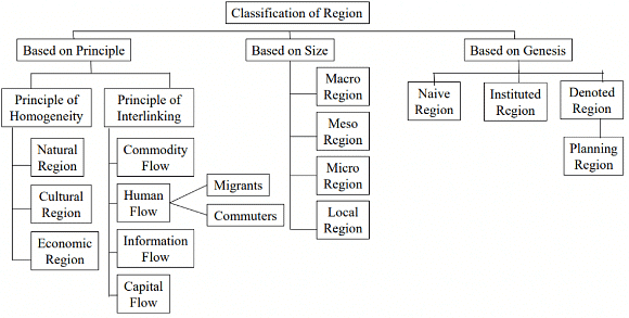
- Regions are classified on the basis of selected criteria and purpose or goal.
- Primarily they are classified as
- Naïve region: It is a mental construct/ idealistic and hypothetical and subjective in nature (e.g. backward region).
- Instituted region
- Denoted region or Planning region
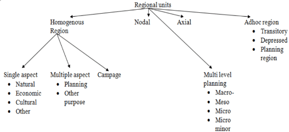
- Several geographers have worked on the typology of regions. Typology approach is also known as classical approach divides the region into Single aspect region
- Multiple aspect region
- Regions of totality
- Functional regions
- Regions can also be classified as
- Regions based on the physical character
- Regions based on cultural character
- Regions based on an amalgamation of physical and cultural variables
- Regions can also be classified on the basis of scale for Multi-Level Planning
- Macro-Macro level for studying a whole nation or state
- Macro-level for studying states within a nation
- Meso level for studying districts
- Micro-level for studying city/village
- Micro minor level for studying a particular sector or household
- Based on Areal homogeneity regions can be classified into
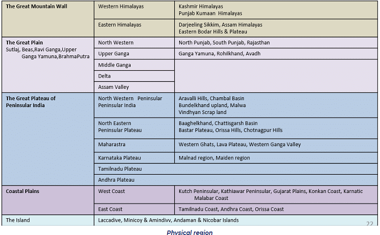
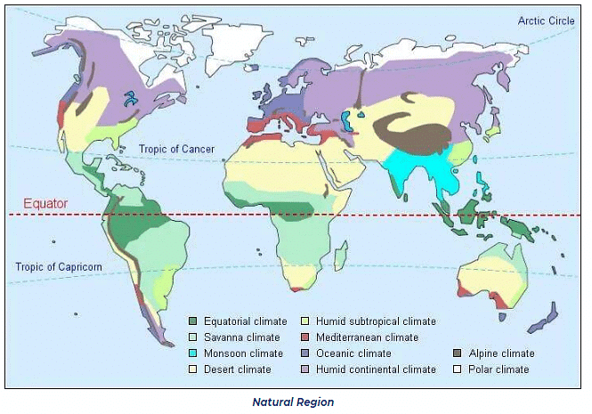
- Physical region: It includes land, soil, climate, vegetation, etc. For example Tropical region, Savanna region, Black soil region, Downs, etc.
- Economic region: It includes industrial regions, agricultural regions, services, etc., for example, Special Economic Zones, Great North Indian Plains.
- Cultural region: the demarcation of the cultural region is based on language, religion, etc. For example Hindi heartland, tribal regions, etc
- Campage Regions with more than one feature showing areal homogeneity. The above regions were demarcated based on a single feature but in Campage more than one features are selected.
- Based on Areal Linkages regions can be classified into
- Nodal region: Here there is one dominant urban centre around which smaller urban/rural areas develop.
- Axial region: It is the region that develops along a corridor and performs a special function. E.g. DMIC along National Highway 8
- Adhoc region: they are transitional regions not on a permanent basis, and are generally backward regions. Here planning is done with a specific purpose in order to develop the particular region.
- Now a day a more comprehensive approach is followed for better planning and development.
Naïve Regions
- These are largely mental constructs and they are perceived section of space
- These have ill-defined boundaries or transitional zone or no boundaries.
- The criteria selected for demarcation are abstract and such regions are more fanciful.
- Such regions don’t have a well-structured association of region-building elements and they are vaguely identified.
- An example of the above is the cultural region because culture can’t be defined in precise terms and within a cultural region, elements of culture have contradictions like marriage rituals vary within the culture.
- The regions get their name by people living outside the region e.g. Mithila, Avadh, etc.
- These naïve regions are further classified as
- Metaphysical region: They don’t exist in reality and more based on philosophy. E.g. concept of heaven/hell, the Marxist idea of the utopian society.
- World/physical regions: They are identifiable, observable but can never be confined within a lined boundary. They are largely transitional. E.g. cultural region Mithila, Avadh, etc.
Instituted Region
- Instituted regions are perhaps the most familiar to the lay public. Open any atlas and the pages are cluttered with them.
- They are created by authorities within some organization—for example, national, state, or local governments, religious organizations, private businesses, and so on.
- These are bounded by administrative boundaries like district or state.
- The regions are created so that the organization can more easily administer whatever activity it is engaged in, whether carrying out planning for the future, collecting revenues, assembling data, or the like. Once instituted, these regions are recognized as existing entities and have boundaries that are clearly demarcated, on paper if not always on the ground; these are usually, but not always, agreed on by everyone.
- Boundaries can be drawn and areas can be demarcated (have empirical stats and not mind-dependent)
- The criteria selected are quantifiable and concise. Such regions are institutionalized and can have legal sanctions.
- Systems of instituted regions are often hierarchical; that is, they nest within one another.
Denoted Region or Planning Region
- Maps of denoted regions are commonly found in geographic and other academic writings. They are created by scholars, perhaps most frequently by geographers, in order to reduce the complexity of the real world so that it can better be understood.
- These are identified by regionalization technique, they are also called planning regions.
- For this reason, they might also usefully be designated as pedagogical regions. The process of creating denoted regions (regionalization) is exactly analogous to the process of classification. When any area (a piece of space) is being divided into regions, what is actually happening is that the places that make up that space are being grouped together because they have something in common.
- It is important to note that such regions are entirely the product of the mind of the person who has created them and have no independent existence.
- Planning Region can be regarded as a district area unit, large and self-contained enough to support life in it and yet small enough to facilitate the understanding of unique local problems.
- It is a unified regional space for which planning decisions are applied (e.g. backward area planning, desert area development plan, etc.)
- It is the segment of territory over which economic decisions apply.
- It may be formal or functional or a combination of both, such regions display coherence of economic decisions.
- Denoted, or pedagogical, regions are of two kinds. Uniform regions, sometimes called formal, are homogeneous (or uniform) with respect to certain selected phenomena, and Nodal regions, sometimes called functional are also denoted but differ from uniform regions in that the places included in them are defined as similar not because they are homogeneous with respect to certain selected criteria but rather because they are all tied to the same central place by the movement of people, ideas, and things. In other words, they all experience more spatial interaction with the same central place or node than they do with any other.
- Formal Regions:
(i) These regions have certain fixed criteria
(ii) The criteria may be physical. E.g. (topography climate, vegetation) or economic like industrial or agricultural (income, rate of unemployment, rate of economic growth) or cultural (language, central India tribal belt)
(iii) They are largely fixed and static.
(iv) They are identifiable by their composition or assemblage of the phenomenon.
Example –
(i) Natural regions like Savanna, rain forest.
(ii) Linguistic regions
(iii) The bioclimatic region, Physiographic region, economic region, hydrological region
- Formal Regions:
- Functional Region:
- It is a geographical area that displays a certain functional coherence i.e. interdependence of parts.
- It is composed of heterogeneous units such as towns, cities, and villages which are functionally interrelated and working as a system
- The relationships are usually studied in form of flow (functional flow between towns and villages). For e.g. journey to work trips or shopping trips, the flow of goods and services, communication, etc.
- Thus, they have flow patterns (flow of goods and services from village to towns) and development of nodes (city and village acts as nodes of flow).
- The criteria taken for the identification of functional region is objective and identifiable e.g. Industrial region, Metropolitan region, Tourism region, Administrative region, Political region, tribal area development, etc.
- Nodal region comprises of the node or core or hub which connects all activities and unifies the region e.g. Mumbai is a node and the sprawling region have interdependency to the node.
- They are suitable for designing and implementing development plans for dealing with regional plans, for dealing with regional problems such as metropolitan or city region, river valley region, axial region (DMIC), transitional/depressed region (e.g. KalahandiBolangir-Koraput (KBK) region).
- According to C.R. Pathak and Amitabh Kundu, a planning region should have the following characteristics:
- It should be large enough to contain a range of resources, conditions, and attributes so as to serve the desired degree of economic viability and at the same time not too large to make a comprehensive approach too general (should not lose its uniqueness).
- It should have a fairly homogeneous economic structure as well as topographical and socio-cultural homogeneity (e.g. KBK region).
- A balance is needed between homogeneity, nodality, and administrative convergence while delimiting a region.
- Planning regions should be internally cohesive.
- Resource should be such that a satisfactory level of product combination for consumption and exchange is feasible.
- It should have few nodal points, to regulate geographically contiguous areal units (e.g. KBK region of Orissa).
- Planning Regions are generally arranged in hierarchical patterns such as Macro, Meso, Micro, etc. Here the bottom-up approach is followed for planning purposes (e.g. village to block to district).
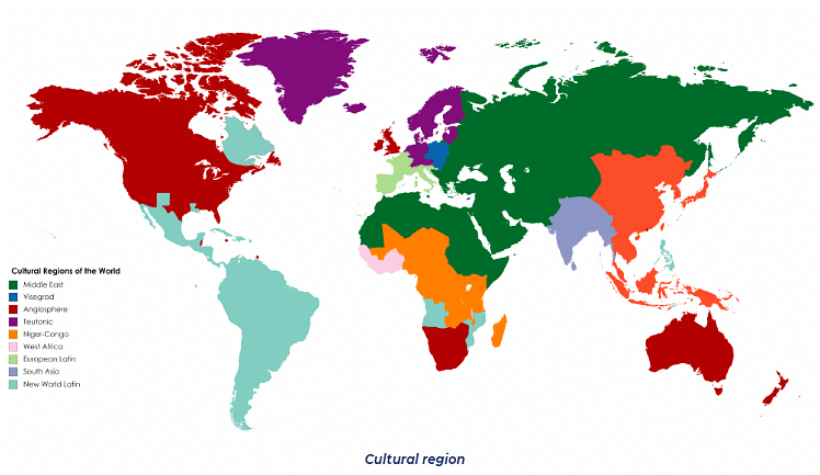
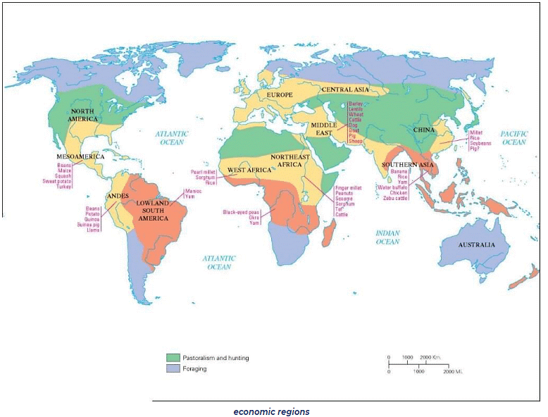
Region & Regionalization
- Regionalisation is the process of delineating regions. In other words, we can define regionalization as the locating of boundaries of a region.
- A region is an area on Earth’s surface marked by a degree of formal, functional, or perceptual homogeneity of some phenomenon. All regions in one way or the other, the level of development.
- Regionalisation may take several forms depending on;
- The purpose of delineating regions.
- The criterion/criteria to be used during delineation e.g. land size, employment rates, activity rates, migration trends, etc.
- Data availability
- Regions can be delineated as;
- Formal regions
- Functional regions
- Planning/Programming regions
Concept of Planning & Planning Regions
Concept of Planning
- Planning means looking ahead and chalking out future courses of action to be followed. It is a preparatory step and systematic activity which determines when, how, and who is going to perform a specific job. Planning is a detailed program regarding future courses of action.
- It is rightly said, “Well plan is half done”. Therefore planning takes into consideration available & prospective human and physical resources of the organization so as to get effective coordination, contribution & perfect adjustment.
- It is the basic management function that includes the formulation of one or more detailed plans to achieve an optimum balance of needs or demands with the available resources.
Planning Region
- A planning region is a segment of territory over which economic decisions apply. The term planning here means taking decisions to implement them in order to attain economic development.
- Planning regions may be administrative or political regions such as state, district, or the block because such regions are better in management and collecting statistical data. Hence, the entire country is a planning region for national plans, the state is the planning region for state plans and districts or blocks are the planning regions for micro-regional plans.
- For proper implementation and realization of plan objectives, a planning region should have a fairly homogeneous economic, topographical and socio-cultural structure.
- It should be large enough to contain a range of resources that provides it economic viability.
- It should also internally cohesive and geographically a contagion area unit.
- Its resource endowment should be that a satisfactory level of product combination consumption and exchange is feasible.
- It should have some nodal points to regulate the flows.
Methods of Regionalization
- Regional delineation is the first step in the preparation of any regional development plan to ensure the tentative operational area of planning. within the planning region, the frame of all regional studies could be undertaken and development envisaged.
- Regionalization is the process of dividing complexity with respect to a region into simple understandable forms.
- The essence of regionalization is uniformity/homogeneity of a region so the method should be such that the region so created has marked dissimilarity with the neighbouring area (Area 1 and Area 2).
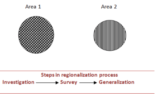
- Steps in the regionalization process involve investigation of the area where regionalization attributes are to be applied, then there will be a thorough survey of the area under consideration which would decide the parameters on which the regionalization is to be done (e.g. region with a high density of population). After the survey of an area with respect to the given parameter is done, there will be generalization based on the above parameters (e.g. areas with a population density of 300, 400, etc.
- Regionalization is based on the investigation. The investigation includes the identification of variables which has bearing on a large number of other variables existing in a given space. (E.g. variables in population include population density, age, etc.)
- The next step in regionalization is a reconnaissance survey which is conducted by more than one observer, thus giving non-coinciding boundaries for the same area.
- The generalization is done wherein the largest number of coinciding interactions is identified.
Different approaches to Regionalization
- Till World War II empirical approach was followed e.g. flow analysis
- During the phase of Quantitative Revolution statistical approach was followed. e.g. Gravity Models
- During the Critical Revolution, empirical cum statistical tools were employed in methods of regionalization. E.g. Delhi NCR.
- Empirical approach
- This approach was popular till World War II
- It was based on observation and assessment for the purpose of demarcation of a region.
- Here the region is demarcated based on the observation of the people.
- The drawback of this approach lies in the fact that there is no clear demarcation of a region based on this method
- Statistical approach
- Due to the Quantitative Revolution gravity models were used for the precise demarcation of a region.
- After the 2nd World War geographers used scientific techniques and precisely demarcated a region from its neighbor regions.
- The sphere of influence of a region was demarcated by using the law of retail trade which states the area of influence of a city or a region in providing goods and services (trade) to adjacent regions by using statistical methods (formulas).
- Empirical cum statistical approach:
- With Critical Revolution in geography, geography is a subject in humanity where some flexibility is required as man is involved, and the scientific approach does not last long.
- Thus, there was a need for empirical cum statistical approach. This approach got tremendous support. For example demarcation of the NCR region of Delhi involves both a statistical approach (area to be included in NCR) and an empirical approach (migration of people in NCR).

Delimitation of a Naive Region
- Due to the complexity and contradictory nature of elements constituting the region, only vague and transitional boundaries can be delineated.
- E.g. it is difficult to draw linear boundaries for a cultural region due to the transitional nature of the zones of cultural regions (Buddhist cultural zones in India).
- The methods involved in the delimitation of the naive region are
- Flow analysis
(i) In this method first, the core is identified, and based on primary data it is estimated that how far flow of goods and services or the traits of culture can be identified
(ii) This method can be used for classifying even the functional region.
➤ E.g. R L Singh analysis of Sphere of Influence or Umland (write about vegetable supply, newspaper supply, etc.)
(iii) For the cultural region the elements of culture are identified say language, religion, dressing sense, etc. and based on their occurrence in surroundings, the regional boundaries can be vaguely drawn - Relative intensity analysis
(i) Let’s suppose (i) and (j) are the two segments of the space and Yi and Yj are the per capita income. The equation Yi-Yj gives the value which is the difference between the Per Capita Income of the two segments.
(ii) A geographer can fix criteria or a limit beyond which the heterogeneity between (i) and (j) is so high that they can be differentiated and classified as regions.
(iii) If the value is less than the criteria, (i) and (j) are homogeneous and can’t be differentiated into two regions. This is the most accepted method which is applied to delimit the naive regions. Although, the boundaries can’t be defined as the naive regions don’t have boundaries that are clear.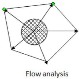
- Flow analysis
Delimitation of Formal Region
- Formal regions have precise boundary limitations. E.g. 18 degrees C isotherm, administrative boundaries, etc.
- Delineation of formal regions involves the grouping together of local units which have similar characteristics according to certain clearly defined criteria and which differ significantly from the units outside the region on the basis of certain chosen criteria.
- The criteria can be unemployment rates, activity rate, migration trends, per capita income, etc.
- The characteristics should differ significantly from units outside the region.
- The delineation depends on the development objectives.
- Variables for delineation of the formal region (homogeneous): Land use characteristics Demographic characteristics; Transport infrastructure; Social service and public utilities; Socio-economic structures.
- There are two techniques for delineation of formal regions are detailed below:
(i) Weighted Index Number Methods
(ii) Factor Analysis Method
Weighted Index Number Methods
- In this method, some indices (parameters) are chosen and given weights, total weights for each part is separately calculated and areas with similar weights are carved out. This area is termed as ‘region’.
- Example: For identifying employment & income level delineation The study area is divided into several localities varying according to unemployment rates and per capita income levels. The aim is to isolate the main problem region; i.e. the area of economic malaise. Weights are assigned to each criterion and when taken together and weighted, one of the regions can be isolated
- If delineation of the formal region is done on the basis of one criterion then we will use the Relative Intensity Analysis Method.
- E.g. say regions (a) and (b) have Per Capita Income Xa and Xb, then these will be included in the same region if Xa=Xb or less than a limit.
- If we consider more than one feature to delineate literacy, industries, per capita income then methods are:
- Fixed index method
- Variable index method
- Cluster method
- Fixed index method:
- Under the fixed index method a number of characteristics (indices) common to regions are chosen. E.g. per capita income, unemployment, rate of industrialization.
- An arbitrary weight is given to each index and a single weighted mean is obtained from each region.
- Then contiguous regions with similar indices are grouped together in order to minimize variance within each group. E.g. HDI index- weighted mean of health indicators, education, and standard of living for a particular region is taken and then the region is delineated by fixing the criteria for high, medium, and low HDI regions (countries or states).
- Variable index method
- Variable weights are assigned to highlight levels of activities in different regions.
- The weight given to each activity in each region is different and in accordance with the value or the volume regionally produced. For example, if region A is the wheat region and region B is coal region then the weight of a wheat index will be the largest in former and weight of coal index will be larger in later.
- This method is good when criteria can be compared with each other.
- However, in those cases where comparability is not possible (e.g. in cases where one feature is literacy and other is steel production), it becomes necessary to employ cluster method.
- In variable index method different problems of a region are taken together and weighted. It is a simple way to delineate regions. However, choice of regional criteria and choice of weight is the problem.
- Cluster method:
- It is used to detect the homogeneous character of the structure of different regional units.
- Parameters/variability is plotted on the same region and more concentration means more clusters. It is a statistical method.
- For this purpose a study of income and trade, flows can be made for the purpose of comparison.
- Here mapping techniques are used to trace the cluster where the interrelated variables are mapped by superimposing techniques.
- Example- frequency of buses from one city to another, traffic zones, circulation of vegetables.
- Cluster method is one of the most easiest and common techniques adopted by geographers and cartographers. E.g. agriculture, minerals, industrial map, rainfall, and soil map to get land-use of area.
- Suppose if the map of India is taken, if we draw the rainfall map of India and above rainfall map, if we plot the soil map and above soil map if we plot water availability map, then we will find that there will be some area with high land use which have high availability of rainfall, soil, and water.
- Various thematic maps superimposed of one variable layer over another helps in demarcating the boundary most common to all phenomena of the region.
Factor Analysis Method
- In this method, each parameter is mapped out separately and then all the maps are kept one over the other. The common region that will be carved out after this exercise will form a region.
- It is a more sophisticated approach.
- Smith used this method for delineating economic-health regions.
- Smith identified 14 industrial criteria on a local employment exchange area base and 14 socio-economic criteria on a local authority base. Many of these criteria are interdependent.
- The factor analysis method can be used to isolate these factors and to group areas on the basis of factor loadings.
- Smith identified ‘industrial change’ and industrial structure’ as major industrial factors, and ‘population change’ and ‘social structure’ as major socio-economic factors. These factors help in delineating economic health regions.
Delineation of Functional Region
- The delineation of the functional region involves grouping together of local units that display a considerable degree of interdependence.
- The concern is thus more with flows linked to a central point rather than with uniformity of the region as a whole
- Two basic approaches to functional regional outlines:
- Flow analysis based on actual observations of what people do
- Gravitational analysis based on theoretical observation of what people might do.
Flow Analysis
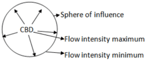
- Flow analysis builds up functional regions on the basis of the direction and intensity of flows between the dominant centre and surrounding satellites.
- Each flow will show decreasing intensity as it becomes more distant from the main centre and increasing intensity as it approaches another centre.
- The boundary of the sphere of influence of the dominant centre will be where the flow intensity at a minimum. When the flow significantly drops that means interaction/origin’s influence drops. In terms of distance, in a particular direction, there is the influence of the node and there onwards it drops. This gives cut off points. Tentative delineation is done.
- In the flow analysis, the processional regions are demarcated based on the direction and intensity of flow between the principal center and the sub-cities around it. The flow decreases according to the distance from the principal center and the effect increases as it approaches the other center. Where the flow intensity around the principal center is minimal, there is a limit to the circumference of the effect of that center.
- This flow can be of any kind,
- economic – such as cargo or passenger, road or rail.
- objective/Purpose – shopping or commuting
- social – the flow of students or hospital patients
- political – the flow of government expenditure
- Information – telegrams, newspaper, telephone calls, etc.
Gravitational Analysis
- The basis of the origin of gravity analysis lies in Newton’s theory. It is based on the possible value of human interaction.
- It is concerned with theoretical forces of attraction between centres rather than actual flow.
- As such it is regarded as 2nd best approach but if used with care as it can provide a good guide to actual flows and more importantly the potential flows between centres.
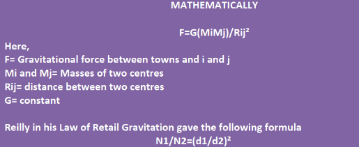
- This rapidly developing field of “social physics” as developed by Zipf, Reilly, Stewart, Stouffer and others is based on a probability view of human interactions and originates from the application of analogous reasoning to Newtonian physics. It means that this method is based on the probability of attraction of flow (flow of goods, services, people, etc) by centre from nearby areas.
- This gravity model assumes that interaction between two centres is proportional to the mass of centres like population, employment, income, expenditure, retail trading, etc. and is inversely proportional to the square of the distance between centres like miles, time and intervening opportunities.
Problems in Delineation of a Region
- Lack of correlation between regions defined according to different criteria.
- Dynamic nature of regional activities
- It is unlikely that regional boundaries defined according to both functional and formal criteria would be closely matched.
- In Gravity Model, it is not easy to calculate M1, M2, R.
- The concept of distance is static.
Other Methods of Regionalization
- Methods of regionalisation can also be classified into
- Qualitative methods
(i) Relative intensity/index method (Ya-Yb)
(ii) Flow analysis
(iii) Skyline method
(iv) Method suggested by R.L. Singh for a city region - Quantitative methods
(i) Method by Stouffer
(ii) Break Point Theory by Converse
(iii) Law of Retail Trade Gravitation by Reilly
(iv) Proximal method
(v) Probabilistic model by Huff
- Qualitative methods
|
304 videos|718 docs|259 tests
|
FAQs on Types of Regions & Methods of Regionalisation - Geography Optional for UPSC
| 1. What are the different types of regions? |  |
| 2. What are some methods of regionalization? |  |
| 3. How are formal regions defined? |  |
| 4. What is the difference between functional and perceptual regions? |  |
| 5. How do methods of regionalization impact governance and development? |  |


