Laws of International Boundaries & Frontiers | Geography Optional for UPSC PDF Download
| Table of contents |

|
| Boundary |

|
| Classification of International Boundaries |

|
| Genetic or Functional Classification |

|
| Morphological Classification |

|
Boundary
It implies the physical limit of sovereignty and jurisdiction of a state; it is a manifestation of integration and is oriented inwards.
Its characteristics are as follows
- It is still possible to recognize frontier characteristics in boundaries, especially in sparsely populated regions, such as deserts. This leads to minimum friction. An example is a boundary between Spain and Portugal.
- It is an appropriate concept for the modern state where all that is within the boundary is bound together by common law, economy, physical features, idea, or creed with a government or central authority in effective control of the territory and activities within the boundaries.
- It may be reached by expanding into frontiers when the natural limits are reached. For instance, the westward expansions of the USA into desert frontiers till the coastlines were reached.
- It is an outer line of effective control of the central government keeping the enemy out and the resources in.
- It is a legal-political phenomenon which is not created but fixed by the political decision-makers.
- It signifies differences in goals, ideology, structure, interests, etc. from those of the neighboring states.
Frontier
In the past, during the political evolutions of a state, states were separated by areas, not lines. The function of the intervening area was to prevent direct contact between the neighboring states and it was referred to as a frontier.
A frontier, can, thus, be defined as a politico-geographical area, lying beyond defined borders of a political unit into which expansion could take place (for instance, European penetration into the Zulu-Natal area and, in modern times, Antarctica). It is a physical and moral concept which implied looking outwards and moving outwards. Some frontiers have occurred where two nations advance from different directions, leading to boundary disputes.
Boundary and Frontier—A Comparison
- A boundary is oriented inwards. It is a manifestation of integration, and is a centripetal force; a frontier is oriented outwards and is a manifestation of the spontaneous tendency to grow, of ecumene, and is a centrifugal force.
- A boundary is created and maintained by the will of the government. It has no life of its own, not even a material existence; a frontier is a ‘fact of life’ and exists physically on ground as a dynamic entity.
- A boundary is well-defined and regulated by law. It possesses uniform characteristics. A frontier is a phenomenon of history and, like history, it is unique.
- A boundary is a separating factor whereas a frontier provides scope for mutual interaction and exchange.
- Boundaries are purely political in origin and function while frontiers are transitional between geographical regions, rather than between the states. Thus frontiers are more geographical rather than political in nature.
- Frontiers are phenomenon of past while boundaries belong to present.
- A frontier whether physical, linguistic, religious, or ethnic can not be moved. It may change its character, and lose much of its frontier function, but it must remain in-situ. In contrast, boundaries are by no means immovable.
Classification of International Boundaries
There are two important systems of classification of international boundaries:
- First is the functional, also called the genetic classification. It is a concept based on the nature of the relationship between the boundary line and the evolution of the cultural landscape of the State whose sovereignty it defines, delimits and separates.
- Secondly, boundaries may be classified in accordance with their form that is in terms of their demarcation and fixation on the ground. A boundary may often be drawn to follow some conspicuous physical feature, such as a mountain range, a river, or a lake. These are physical or physiographic boundaries.
Boundaries may also be drawn to follow a geometrical line (geometrical or straight-line boundaries) or to separate certain ethnic communities (ethnic or anthropogeographic boundaries). In most boundaries, however, more than one criterion of delimitation may be involved. Most boundaries are, therefore, complex in nature. This classification is called the morphological classification.
Genetic or Functional Classification
The genetic classification of boundaries is based on the relationship that a boundary line had shared with the surrounding cultural landscape at the time of its demarcation. It was derived from physical geography, although the analogy between the mechanics of river development and the dynamics of international boundaries is no doubt, imperfect.
- Antecedent boundaries
- Subsequent boundaries
- Super-imposed boundaries
- Relic or Relict boundaries
1. Antecedent boundaries
Boundaries that predated the evolution of the cultural landscape are called antecedent boundaries. They are the most common type to come across in the New World. Here international boundaries were generally agreed upon at the conference table even before the concerned territory was fully explored, and colonized so that they are mostly straight line geometrical boundaries. Ex: States of USA, Alaska & Canada, Australia etc.
2. Subsequent boundaries
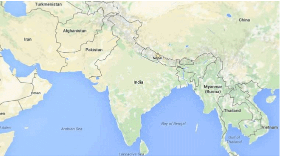
Those boundaries whose definition and demarcation had followed the evolution of the cultural landscape are called subsequent boundaries. Such boundaries often conform to ethnic-cultural divisions of the landscape especially the divisions of language and religion. Most boundaries in Eastern Europe, and those between India and Pakistan, and India and Bangladesh belong to this type. Certain subsequent boundaries are superimposed in nature. These were also drawn after the cultural landscape had fully evolved. The difference lies in that the subsequent type conforms to the cultural division between neighboring communities, and was decided upon through mutual agreement.
Super-imposed boundaries
The super-imposed type, in contrast, does not conform to the social-cultural divisions on the ground. They were imposed upon the concerned communities, either by outside powers or the overbearing unit between the two. Most colonial boundaries in Africa are of this type. Truce-line boundaries also belong to this type.
3. Relic or Relict boundaries
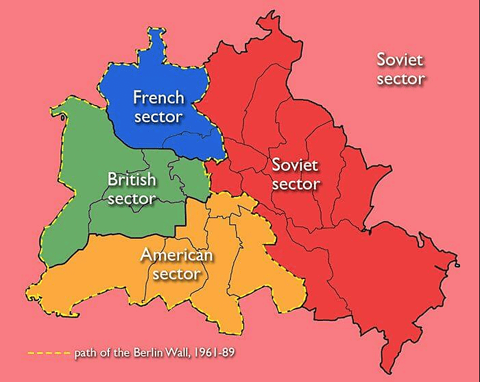
A fourth type called Relic or Relict boundaries are those boundary lines which have currently lost political function, but which may still be discernible in the cultural landscape. Such boundary lines result when a smaller State is absorbed by a larger one, or when frontier boundaries between States are abandoned and redrawn.
 West and East Germany
One example is the Berlin Wall, which was built in 1961 by Soviet-controlled East Germany to contain the portion of the city that had been given over to America, England, and France to administer.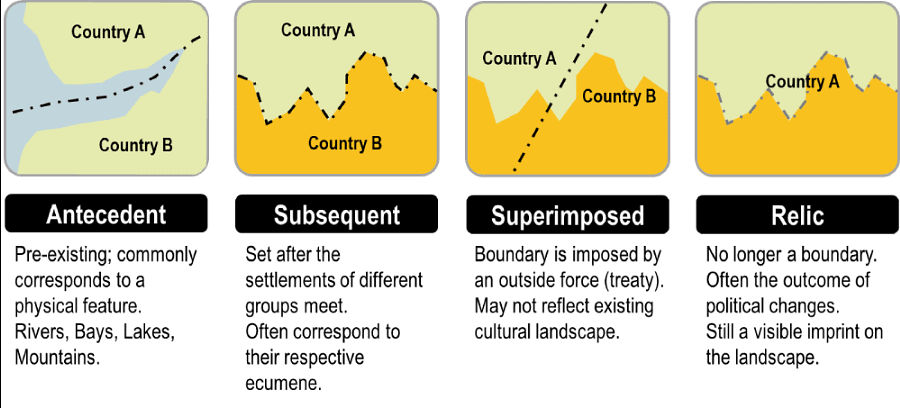
Morphological Classification
Morphological boundaries are those that were drawn to follow some conspicuous feature of the physical landscape. Since these boundaries follow some natural feature of the physical landscape, they are sometimes wrongly referred to as natural boundaries, as contrasted to the boundaries drawn to follow certain geometrical lines or the divisions of language or religion. The latter is sometimes referred to as artificial boundaries. This distinction is, however, not correct. All boundaries are man-made, hence all are artificial.
- Physiographic Boundaries
- Mountain Boundaries
- Rivers as International Boundaries
- Boundaries in Lakes and Straits
- Forest, Swamp, and Deserts
Mountain Boundaries
They have been the most favored type since they have traditionally served as natural barriers. Being firmly fixed on the ground, mountain boundaries were considered to be highly stable.
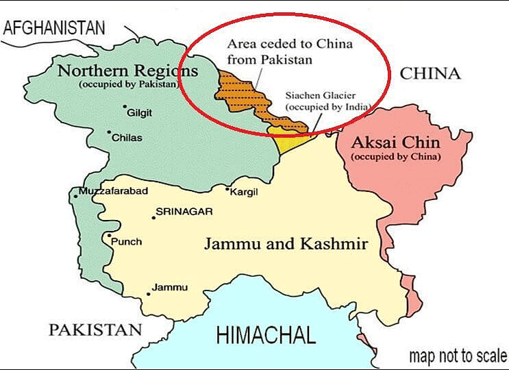
However, revolutionary changes in transport and communication, and the opening of the sky as a highway, has greatly reduced their function as protective barriers. As the Chinese invasion of India across the Himalayas has proved, even the loftiest of the mountain ranges are no longer impregnable. The location of the boundary line along with a mountain range often poses difficult problems, since most mountain ranges do not possess a well-defined crest line. Even where the crest lines exist, they are often divided by transverse valleys. Besides, most mountain ranges consist of several semi-parallel ranges, each with its separate crest line. Therefore, contrary to popular belief, the coincidence between the crest line and the water divide between streams flowing down its opposite slopes, is seldom found.
 India China Pakistan Border
Both the Indus and the Brahmaputra originate in the Mansarower lakes and thus drain both the Himalayan and the trans-Himalayan regions to the sea by the combined river system of the Ganga and the Brahmaputra.
Rivers as international boundaries
Many international boundaries are based on river streams. The advantages of selecting a river as boundary are:
- It is a clearly marked feature on the map;
- It is a more narrowly defined (almost linear) feature than mountains and hills; and
- Wide, unfordable streams had previously served as barriers to communication, and, as such, were thought to possess some military value by serving as possible lines of defense against an advancing army.
Irrespective of these advantages the choice of rivers as international boundaries has seldom proved satisfactory. First drainage basins generally tend to exert a unifying rather than a separating influence, since rivers and their valleys provide lines of movements that promote social and commercial intercourse. River basins generally consist of fertile alluvial plains supporting dense populations. Therefore, an international boundary drawn along or across a river disrupts settled communities and creates problems in river water utilization and management. The India-Pakistan boundary through the Indus basin and the Indo-Bangladesh boundary are two important cases in point.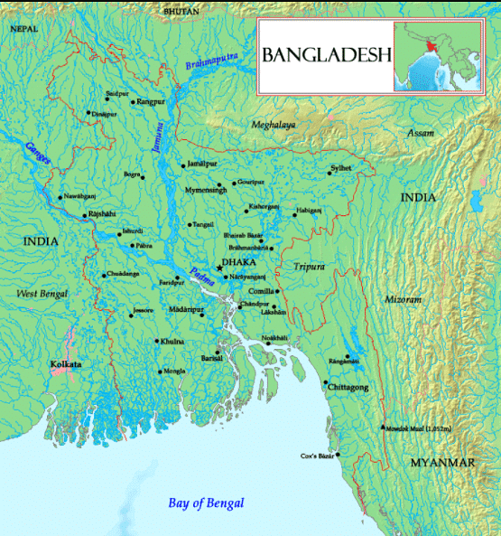 Bangladesh International Boundaries
Once a river is selected to serve as the boundary between two adjacent States, the problem arises as to how to locate the boundary line. Generally, the boundary line may follow the median line or the middle of the navigable channel, or it may adopt one of the shorelines. A median line may be defined as the line joining all points which are equidistant from the nearest points on opposite shores.
The main difficulty in the adoption of the median line as the boundary is that it makes an equal division of the water surface rather than its volume. The adoption of the navigable channel’s inter-State boundary presents its own set of problems owing to its highly zigzag course and frequent changes in its position that may lead to recurrent dislocation of life along the border zone.
Location of the boundary through a navigable lake poses equally difficult problems, though no dislocation of settled communities may be involved.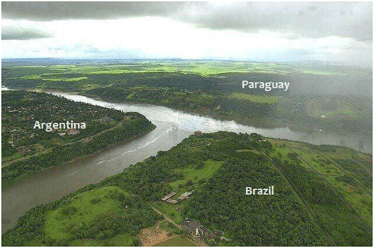
|
303 videos|636 docs|252 tests
|
FAQs on Laws of International Boundaries & Frontiers - Geography Optional for UPSC
| 1. What are the main principles governing international boundaries and frontiers? |  |
| 2. How are international boundaries established and recognized? |  |
| 3. What role do international organizations play in boundary disputes? |  |
| 4. What are some common challenges faced in managing international boundaries? |  |
| 5. How do changes in technology affect international boundaries and frontier management? |  |


