Drainage System & Watersheds | Geography Optional for UPSC PDF Download
Indian River System
The Indian River System primarily consists of rivers that empty their waters into the Bay of Bengal. However, some rivers flow through the western part of the country and merge into the Arabian Sea. Inland drainage occurs in the northern parts of the Aravalli Range, some regions of Ladakh, and the arid areas of the Thar Desert. All major Indian rivers originate from one of three primary watersheds:- The Himalaya and Karakoram mountain ranges
- The Chota Nagpur Plateau, as well as the Vindhya and Satpura ranges
- The Western Ghats
This information highlights the diverse sources and pathways of the rivers within the Indian River System.
Classification of Drainage Systems of India
Drainage Systems Based on the Size of the Catchment Area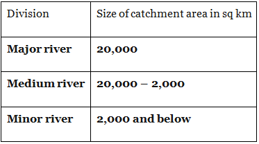
Drainage Systems Based on Origin
India's drainage systems can be classified based on their origin into two main categories:
- The Himalayan Rivers: These perennial rivers include the Indus, Ganga, Brahmaputra, and their tributaries. They originate from the Himalayas and flow throughout the year, providing a constant water supply.
- The Peninsular Rivers: These non-perennial rivers include the Mahanadi, Godavari, Krishna, Cauvery, Narmada, and Tapi, along with their tributaries. They are primarily found on the Indian Peninsula and their water flow can be seasonal, depending on rainfall.
Drainage Systems Based on the Type of Drainage
India's river systems can also be classified into four groups according to their drainage patterns:
- Himalayan rivers, Deccan rivers, and Coastal rivers: These rivers drain into the sea, providing an outlet for the water they carry.
- Inland drainage basin (endorheic basin) rivers: These rivers, such as the seasonal Sambhar in western Rajasthan, drain into inland basins and salt lakes. The Luni is the only river that flows through the Rann of Kutch, a salt desert.
Drainage Systems Based on Orientation to the Sea
India's rivers can also be categorized based on the direction in which they flow towards the sea:
- Bay of Bengal drainage: These east-flowing rivers drain into the Bay of Bengal, contributing to its water volume.
- Arabian Sea drainage: These west-flowing rivers, such as the Narmada and Tapi, drain into the Arabian Sea. Although the Narmada and Tapi flow parallel to each other, they empty in opposite directions. The valleys they create are rich in alluvial soil and teak forests, making the land fertile and lush.
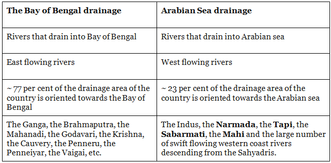
Over 90 per cent of the water drains into the Bay of Bengal; the rest is drained into the Arabian Sea or forms inland drainage.
Contribution of Water by Various Rivers
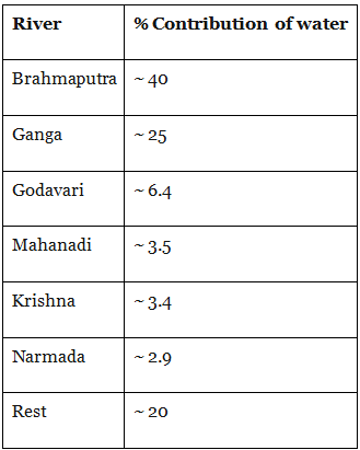
Major River System or Drainage Systems in India
Himalayan River systems
- Indus River System
- Brahmaputra River System
- Ganga River System
Peninsular River Systems
- Godavari River System
- Krishna River System
- Cauvery River System
- Mahanadi River System
West Flowing Peninsular River Systems
- Narmada River System
- Tapti River System
- Sabarmati River
- Mahi River
- Luni River
The Indus River System
- The Indus River System originates from the northern slopes of the Kailash range in Tibet, near Lake Manasarovar. It spans a total length of approximately 2,897 kilometers from its source to its endpoint near Karachi, where it empties into the Arabian Sea, with about 700 kilometers of the river flowing through India. The Indus enters Indian territory in Jammu and Kashmir, creating a stunning gorge.
- In the Kashmir region, the Indus is joined by several tributaries, including the Zaskar, Shyok, Nubra, and Hunza rivers. The river flows between the Ladakh and Zaskar Ranges at Leh and traverses the Himalayas through a deep gorge, approximately 5,181 meters in depth, near Attock, located north of Nanga Parbat. The primary tributaries of the Indus River in India are the Jhelum, Ravi, Chenab, Beas, and Sutlej rivers.
The Brahmaputra River System
- The Brahmaputra River System is a significant river system that originates from Mansarovar Lake, which is also the source of the Indus and Sutlej rivers. With a length of 3,848 kilometers, it is slightly longer than the Indus River, and most of its course lies outside India.
- Flowing eastward parallel to the Himalayas, the river reaches Namcha Barwa and takes a U-turn around the mountain before entering India in the state of Arunachal Pradesh. In this region, it is known as the Dihang River. The Brahmaputra flows through the Indian states of Arunachal Pradesh and Assam, where it is joined by several tributaries.
- Throughout most of its length in Assam, the Brahmaputra has a braided channel. In Tibet, where it is called the Tsangpo, the river receives less water and carries less silt. However, once it enters India, it passes through a region of heavy precipitation, causing the river to carry large amounts of water during rainfall and a significant amount of silt. This makes it one of India's largest rivers in terms of volume.
- The Brahmaputra River is known for causing disasters in Assam and Bangladesh due to its large volume and heavy precipitation.
Ganga River System
- The Ganga River System originates from the Gangotri glacier, where the Bhagirathi River forms. As the river flows towards Devprayag in the Garhwal Division, several other rivers merge with it, including the Mandakini, Pindar, Dhauliganga, and Bishenganga, which join the Alaknanda River, and the Bheling, which drains into the Bhagirathi River.
- The Pindar River, originating from East Trishul and Nanda Devi, unites with the Alaknanda at Karan Prayag, while the Mandakini meets the Alaknanda at Rudraprayag.
- Finally, the waters of both the Bhagirathi and Alaknanda rivers merge at Devprayag, continuing to flow as the Ganga River.
The concept of Panch Prayag
- Vishnuprayag: where the river Alaknanda meets river Dhauli Ganga
- Nandprayag: where river Alaknanda meets river Nandakini
- Karnaprayag: where river Alaknanda meets river Pinder
- Rudraprayag: where river Alaknanda meets river Mandakini
- Devprayag: where river Alaknanda meets river Bhagirathi -GANGA
The principal tributaries of the Ganga are Yamuna, Damodar, Sapta Kosi, Ram Ganga, Gomati, Ghaghara, and Son. The river after traveling a distance of 2525 km from its source meets the Bay of Bengal.
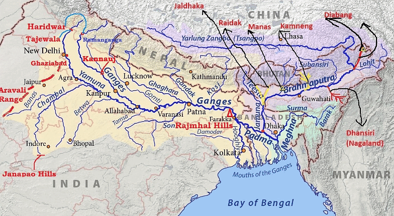 Ganga System
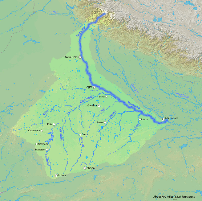
Yamuna River System
- The Yamuna River, the most significant tributary of the Ganga River, has its source at the Yamunotri glacier, located on the Bandarpoonch peak in Uttarakhand.
- Several main tributaries, such as the Sin, Hindon, Betwa Ken, and Chambal, merge with the Yamuna River along its course. Among these, the Tons is the largest tributary of the Yamuna.
- The river's drainage basin spans across several states, including Delhi, Himachal Pradesh, Uttar Pradesh, Haryana, Rajasthan, and Madhya Pradesh.
- The Narmada is a river located in central India.
- It rises to the summit of the Amarkantak Hill in Madhya Pradesh state.
- It outlines the traditional frontier between North India and South India.
- It is one of the major rivers of peninsular India. Only the Narmada, the Tapti, and the Mahi rivers run from east to west.
- The river flows through the states of Madhya Pradesh, Gujarat, and Maharashtra.
- It drains into the Arabian Sea in the Bharuch district of Gujarat.
The Tapi River System
- The Tapi River System is a significant central Indian river that flows from east to west and is a crucial water source for peninsular India. Its origin can be traced to the Eastern Satpura Range in the southern region of Madhya Pradesh state. As it flows westward, the Tapi River drains historically important areas such as Madhya Pradesh's Nimar region, East Vidarbha region, Maharashtra's Khandesh in the Deccan Plateau's northwest corner, and South Gujarat, before eventually emptying into the Gulf of Cambay in the Arabian Sea.
- The Tapi River Basin predominantly spans across eastern and northern districts of Maharashtra state, while also covering some districts in Madhya Pradesh and Gujarat. Among its main tributaries are the Waghur River, Aner River, Girna River, Purna River, Panzara River, and Bori River.
The Godavari River System
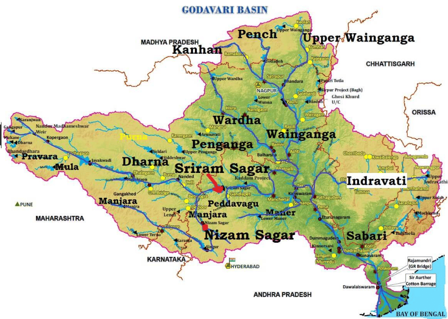 Godavari system
- The Godavari River, known as the second-longest river in India, has a distinct brownish hue to its waters. Often referred to as Dakshin (South) Ganga or Vriddh (Old) Ganga, the Godavari is a seasonal river that dries up during the summer months and expands during the monsoon season. The river's source is in Trimbakeshwar, near Nasik in Maharashtra.
- Flowing southeast, the Godavari traverses through south-central India, passing through the states of Madhya Pradesh, Telangana, Andhra Pradesh, and Orissa, before emptying into the Bay of Bengal. At Rajahmundry, the river forms a fertile delta, which is home to numerous pilgrimage sites, including Nasik in Maharashtra, Bhadrachalam in Telangana, and Trimbak.
- The Godavari River has several tributaries, such as Pranahita (a combination of the Penuganga and Warda rivers), Indravati River, Bindusara, Sabari, and Manjira. Notably, Asia's largest rail-cum-road bridge, which connects Kovvur and Rajahmundry, is situated on the Godavari River.
The Krishna River System
- Krishna is one of the longest rivers of India, which originates from Mahabaleshwar in Maharashtra.
- It flows through Sangli and drains the sea in the Bay of Bengal.
- The river flows through the states of Maharashtra, Karnataka, Telangana and Andhra Pradesh.
- Tungabhadra River is the main tributary which itself is formed by the Tunga and Bhadra rivers that originate in the Western Ghats.
- Dudhganga Rivers, Koyna, Bhima, Mallaprabha, Dindi, Ghataprabha, Warna, Yerla, and Musi are some of the other tributaries.
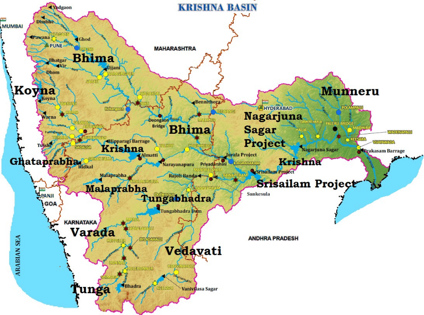 Krishna system
The Cauvery River System
- The Cauvery is also known as Ganges of South India “Dakshi Bharat ki Ganga”.
- It originates from Talakaveri located in the Western Ghats.
- It is a famous pilgrimage and tourist place in the Kodagu district of Karnataka.
- The headwaters of the river are in the Western Ghats range of Karnataka state, and from Karnataka through Tamil Nadu.
- The river drains into the Bay of Bengal. The river supports irrigation for agriculture and is considered as a means of support of the ancient kingdoms and modern cities of South India.
- The river has many tributaries called Arkavathy, Shimsha, Hemavati, Kapila, Shimsha, Honnuhole, Amaravati, Lakshmana Kabini, Lokapavani, Bhavani, Noyyal, and Tirtha.
The Mahanadi River System
- The Mahanadi originates from the Satpura Range of central India and it is a river in eastern India.
- It flows east to the Bay of Bengal. The river drains of the state of Maharashtra, Chhattisgarh, Jharkhand, and Orissa.
- The largest dam, the Hirakud Dam is built on the river.
Ganga–Brahmaputra Delta
- Before entering the Bay of Bengal, the Ganga, along with the Brahmaputra, forms the largest delta of the world between the Bhagirathi/Hugli and the Padma/Meghna covering an area of 58,752 sq km.
- The coastline of the delta is a highly indented area.
- The delta is made of a web of distributaries and islands and is covered by dense forests called the
- A major part of the delta is a low-lying swamp that is flooded by marine water during high tide.
Alaknanda
- It is one of the headstreams of the Ganga.
- It rises at the confluence and feet of the Satopanth and Bhagirath glaciers in Uttarkhand.
- It meets the Bhagirathi River at Devprayag after which it is called as the Ganga.
- Its main tributaries are the Mandakini, Nandakini, and Pindar rivers.
- The Alaknanda system drains parts of Chamoli, Tehri, and Pauri districts
- The Hindu pilgrimage center of Badrinath and the natural spring Tapt Kund lie along the banks of the Alaknanda River
- At Its origin, Lake Satopanth is a triangular lake located at a height of 4402m and named after the Hindu trinity Lord Brahma, Lord Vishnu, and Lord Shiva.
Bhagirathi
- It is one of the two most important headstreams of the Ganga which meets the Alaknanda at Devprayag to form the Ganga
- It rises at the foot of Gangotri Glacier, at Gaumukh, at an elevation of 3892m at the base of Chaukhamba peak in the Uttarkashi district of Uttarakhand
- The upper catchment of the river is glaciated
- It cuts spectacular gorges in its middle course where it has cut through granites and crystalline rocks of the central Himalayan axis
- Gangotri, Uttarkashi, and Tehri are important settlements along the river.
Dhauliganga
- The Dhauliganga River, a significant tributary of the Alaknanda River, originates from Vasudhara Tal, which is possibly the largest glacial lake in Uttarakhand. The Alaknanda River has other important tributaries, including the Nandakini, Pindar, Mandakini, and Bhagirathi rivers. The Dhauliganga River meets the Rishiganga River at Raini and eventually merges with the Alaknanda River at Vishnuprayag, where it loses its individual identity.
- From there, the Alaknanda River flows southwest through various locations, such as Chamoli, Maithana, Nandaprayag, and Karnaprayag, before joining the Mandakini River from the north at Rudraprayag. After absorbing the Mandakini, the Alaknanda River continues past Srinagar and ultimately meets the Ganga River at Devprayag. At this point, the Alaknanda River ceases to exist, and the mighty Ganga River continues its journey, flowing first south, then west through significant pilgrimage centers like Rishikesh, and finally descending into the Indo-Gangetic plains at Haridwar.
- The Tapovan Vishnugad Hydropower Project is currently under construction on the Dhauliganga River.
Rishiganga River
- It is a river in the Chamoli district, Uttarakhand.
- It springs from the Uttari Nanda Devi Glacier on the Nanda Devi Mountain.
- It is also fed from the Dakshini Nanda Devi Glacier.
- It flows through the Nanda Devi National Park and merges into the Dhauliganga River near the village Raini.
Major Tributaries of the Ganga River
- Right Bank Tributaries of the Ganga River
- Yamuna River
(i) Chambal River
(ii) Banas River
(iii) Sind River
(iv) Betwa River - Ken River
- Son River
- Damodar River
- Yamuna River
- Left Bank Tributaries of the Ganga River
- Ramganga River
- Gomti River
- Ghaghra River
- Kali River
- Gandak River
- Burhi Gandak
- Kosi River
Ramganga
- A tributary of the Ganga river, it drains south-western Kumaun.
- Ramganga River originates in the southern slopes of Dudhatoli Hill in the Chamoli district of Uttarakhand.
- It is fed by springs emanating from the reservoirs of underground water
- The prominent geomorphic features found in its tract across the lower Himalayan hills of Almora district are incised meanders, paired and unpaired terraces, interlocking spurs, waterfalls, rock benches, cliffs, and towering ridges
- It also flows through the dun valley of Corbett National Park.
- There is a dam built across the Ramganga at Kalagarh
- It finally meets the Ganga near Kannauj.
- Bareilly city is situated on its banks.
Gomti
- It originates from Gomat Taal which formally is known as Fulhaar jheel, near Madho Tanda, Pilibhit in UP.
- It extends 900km through UP and meets the Ganges River in Ghazipur.
- At the Sangam of Gomti and Ganga, the famous Markandey Mahadeo temple is situated.
- The most important tributary is the Sai River, which joins near Jaunpur
- The cities of Lucknow, Lakhimpur Kheri, Sultanpur and Jaunpur are located on the banks of Gomti
- The river cuts the Jaunpur city into equal halves and becomes wider in Jaunpur.
Ghaghara
- The Ghaghara originates in the glaciers of Mapchachungo.
- Alternatively known as Karnali or Kauriala, it is a trans-boundary perennial river originating from the Tibetan plateau near Lake Mansarovar.
- It cuts through the Himalayas in Nepal and is joined by the Sharda River at Brahmaghat in India
- It is a major left-bank tributary of the Ganga and joins it at Chhapra in Bihar.
- Its total length is 1080km
- This river is the main source of water in Bara-Banki District of UP.
- Rapti, Chhoti Gandak, Sharda, and Sarju are the major tributaries of this river.
Sharda
- The Sarda river rises in the Milam glacier in the Nepal Himalayas where it is known as the Goriganga.
- The Sharda originates from the Greater Himalayas at Kalapaani at an altitude of 3600m in the Pithoragarh District of Uttarakhand.
- Kalapaani is situated on the route of Kailash Manasarovar Yatra tour
- It is named as River Mahakali in Nepal and the name is after the Goddess Kali whose temple is situated in Kalapaani near the Lipu-Lekh pass at the border between India and the Tibet
- The river borders the Nepalese Mahakali Zone and Uttarkhand.
- The river flows in a gorge section in the upper region.
- The Mahakali after it descends into the plains into India is known as Sarda, which meets the Ghaghara.
Sarayu
- (Also called Sarju). It is a river that flows through UP.
- Sarayu is a river that originates at a ridge south of Nanda Kot mountain in Bageshwar district in Uttarakhand.
- This river is of ancient significance, finding mentions in Vedas and Ramayana
- It is a left-bank tributary of River Ghaghara
- On Ram Navami, the festival that celebrates the birthday of Lord Ram, thousands of people take a dip in the sacred river Sarayu at Ayodhya.
Rapti
- The Rapti rises south of a prominent E-W ridgeline midway b/w the western Dhaulagiri Himalaya and the Mahabharat Range in Nepal
- The mainstream of this river rises as a spring in the southern slopes of the Lower Himalayas
- The river is essentially fed by underground water
- It has the tendency of recurrent floods that led to its nickname “Gorakpur’s Sorrow”
- Lungri Khola, Jhimruk Khola, Ami River, Rohini River are the major left-bank, and Arun Khola is the right bank tributary of the Rapti.
Gandak
- It is formed by the union of the Kali and Trisuli rivers, which rise in the Great Himalayan Range in Nepal
- From this junction to the Indian border the river is called the Narayani
- It enters the Ganga river opposite Patna in a place called Sonepur after a winding course of 765 km
- The Burhi Gandak flows parallel to and east of the Gandak River
- The upper catchment area of the river is bleak and desolate lying in the rain shadow area of the Himalayan range
- The middle and the lower courses of the river flows through the V-shaped valleys, incised meanders, and have paired and unpaired terraces on either sides.
Burhi Gandak
- This 320km long river originates from Chautarva Chaur near Bisambharpur in the district of West Champaran district of Bihar
- It initially flows through the East Champaran district.
- After flowing for a distance of about 56km the river takes a southerly turn where two rivers – the Dubhara and the Tour- join it.
- Thereafter, the river flows in a south-easterly direction through the Muzaffarpur district for about 32km.
- It flows parallel to and east of the Gandak River in an old channel.
- The main tributaries of the Burhi Gandak are – Masan, Balor, Pandai, Sikta, Tilawe, Tiur, Dhanauti, Kohra, and Danda
- Samastipur is situated on it.
- There is no major or medium project over the Burhi Gandak river system.
Kosi
- Aka Saptakoshi for its 7 Himalayan tributaries, it is an antecedent transboundary river flowing through Nepal and India
- Some of the rivers of the Kosi system, such as the Arun, the Sun Kosi, and the Bhote Koshi, originate in the Tibet
- This 729km long river is one of the largest tributaries of the Ganga and joins it at Kursela in Kathiar district
- The highest peak in the world, Mt.Everest and the Kanchenjunga are in the Kosi catchment.
- Bagmati is an important tributary of the Kosi.
- Over the last 250 years, the Kosi river has shifted its course over 120km from east to west
- Its unstable nature has been attributed to the heavy silt it carries during the monsoon season, Due to this, it is also termed as “The Sorrow of Bihar”.
Son River
- The Son, 784km long, originates near Amarkantak in MP, just east of the headwater of the Narmada River, and flows north-northwest through MP before turning sharply eastward where it encounters the southwest-northeast running Kaimur Range
- The Son parallels the Kaimur hills, flowing east-northeast through UP, Jharkhand, and Bihar states to join the Ganga just above Patna
- Geologically. The lower valley of the Son is an extension of the Narmada Valley, and the Kaimur Range an extension of the Vindhya Range
- Dehri is the major town situated on Son River.
- Tributaries of Son river
- Right – Gopad Rive, Rihand River, Kanhar River, North Koel River
- Left – Ghaggar River, Johila River, Chhoti Mahanadi River
- Its chief tributaries are the Rihand and the North Koel. It is largely forested and sparsely populated.
Rihand
- The Rihand rises from Matiranga Hills in the region southwest of the Mainpat plateau, which is about 1000m in Chhatisgarh
- The Rihand and its tributaries form a fertile plain in the central part of the district stretching from around Ambikapur to Lakhanpur and Pratappur
- Thereafter, it flows north into Sonbhadra district of UP, where it joins the Son.
- Its principal tributaries are the Mahan, the Morana(Morni), the Geur, the Gagar, the Gobri, the Piparkachar, the Ramdia, and the Galphulla
- The Rihand Dam was constructed across the Rihand River near Pipri in Sonbadra district of Mirzapur division in 1962 for hydropower generation: the reservoir impounded behind the dam is called Govind Ballabh Pant Sagar.
North Koel
- This 260km long river rises on the Ranchi plateau and enters Palamau division below Netarhat near Rud
- After flowing nearly due west for about 30km, it turns north at an almost complete right angle through a gorge at Kutku and flows through the centre of the district till it falls into the Son a few miles northwest of Haidamagar
- The North Koel, along with its tributaries, meanders through the northern part of Betla National Park
- The principal tributaries are the Auranga, the Amanat, and the Burha.
Namami Gange Yojana
- The Namami Gange Project, also known as Namami Ganga Yojana, is a comprehensive initiative by the Union Government of India to clean and protect the Ganga River. With an initial budget allocation of Rs. 2037 Crore, the project is officially known as the Integrated Ganga Conservation Mission. It aims to rejuvenate the Ganga by consolidating existing ongoing efforts and creating a concrete action plan for the future.
- Operating under the Department of Water Resources, River Development, and Ganga Rejuvenation, Ministry of Jal Shakti, the project has a centrally-funded, non-lapsable corpus of Rs. 20,000 crore and comprises nearly 288 projects. The initiative covers eight states, 47 towns, and 12 rivers, with the goal of making over 1,632 gram panchayats on the banks of the Ganga open defecation-free by 2022.
- Several ministries are collaborating with the nodal Water Resources Ministry on this project, including the Environment, Urban Development, Shipping, Tourism, and Rural Development Ministries. The primary focus is to involve the communities living along the river's banks in the project's implementation.
- The program is being executed by the National Mission for Clean Ganga (NMCG) and its state counterpart organizations, the State Program Management Groups (SPMGs). The NMCG serves as the implementation arm of the National Ganga Council, which was established in 2016 to replace the National Ganga River Basin Authority (NRGBA).
Key initiatives of the project include:
- Implementing river-centric urban planning processes to improve citizen engagement through interventions at ghats and riverfronts.
- Expanding sewerage infrastructure coverage in 118 urban habitations along the banks of the Ganga.
- Enforcing Ganga-specific River Regulatory Zones.
- Promoting rational agricultural practices and efficient irrigation methods.
- Establishing a Ganga Knowledge Centre.
To tackle pollution, the project will employ various strategies, such as:
- Treating wastewater in drains using bio-remediation methods.
- Applying in-situ treatment for wastewater.
- Utilizing innovative technologies for wastewater treatment.
- Establishing municipal sewage and effluent treatment plants.
- Implementing immediate measures to prevent sewage inflow.
- Introducing a public-private partnership approach for pollution control.
- Creating a four-battalion Territorial Army Ganga Eco-Task Force.
Other Initiatives Taken
Several initiatives have been undertaken to clean and protect India's rivers, particularly the Ganga River. Some of these initiatives include:- Ganga Action Plan (GAP): Launched in 1985 by the Ministry of Environment, Forest, and Climate Change, GAP was the first River Action Plan aimed at improving water quality by intercepting, diverting, and treating domestic sewage.
- National River Conservation Plan (NRCP): This plan serves as an extension of the Ganga Action Plan and focuses on cleaning the Ganga River under its second phase.
- National River Ganga Basin Authority (NRGBA): Established by the Indian Government in 2009 under Section-3 of the Environment Protection Act, 1986, the NRGBA declared the Ganga as India's 'National River.'
- Clean Ganga Fund (CGF): Launched in 2014, the CGF aims to clean the Ganga River by establishing waste treatment plants and conserving the river's biotic diversity.
- Bhuvan-Ganga Web App: This web application encourages public involvement in monitoring pollution entering the Ganga River, making the process more transparent and accountable.
- Ban on Waste Disposal: In 2017, the National Green Tribunal prohibited the disposal of any waste in the Ganga, further strengthening efforts to protect the river and its ecosystem.
Conclusion
In conclusion, the Indian River System is a complex and diverse network of rivers that play a crucial role in the country's water supply and ecosystem. These rivers can be classified based on their origin, drainage patterns, and orientation to the sea. The major river systems include the Indus, Ganga, Brahmaputra, and their tributaries in the Himalayas, as well as the peninsular rivers such as the Mahanadi, Godavari, Krishna, Cauvery, Narmada, and Tapi. These rivers provide essential water resources for agriculture, support numerous ecosystems, and possess cultural and religious significance for the people of India.Frequently Asked Questions (FAQs) of Drainage System & Watersheds
What are the two main categories of India's drainage systems based on their origin?
The two main categories of India's drainage systems based on their origin are the Himalayan Rivers, which include the Indus, Ganga, Brahmaputra, and their tributaries, and the Peninsular Rivers, which include the Mahanadi, Godavari, Krishna, Cauvery, Narmada, and Tapi, along with their tributaries.
What is the primary difference between the Himalayan Rivers and the Peninsular Rivers?
The primary difference between the Himalayan Rivers and the Peninsular Rivers is that the Himalayan Rivers are perennial, meaning they flow throughout the year and provide a constant water supply, while the Peninsular Rivers are non-perennial and their water flow can be seasonal, depending on rainfall.
Which river system in India is considered the second-longest and is often referred to as Dakshin (South) Ganga or Vriddh (Old) Ganga?
The Godavari River System is considered the second-longest river in India and is often referred to as Dakshin (South) Ganga or Vriddh (Old) Ganga.
Which river in India is known for causing disasters in Assam and Bangladesh due to its large volume and heavy precipitation?
The Brahmaputra River is known for causing disasters in Assam and Bangladesh due to its large volume and heavy precipitation.
What is the largest delta in the world, formed by the Ganga and Brahmaputra rivers?
The Ganga-Brahmaputra Delta, located between the Bhagirathi/Hugli and the Padma/Meghna, is the largest delta in the world, covering an area of 58,752 sq km.
|
303 videos|636 docs|252 tests
|
FAQs on Drainage System & Watersheds - Geography Optional for UPSC
| 1. What is the Indian River System? |  |
| 2. How are the drainage systems in India classified? |  |
| 3. Which rivers contribute the most water to India? |  |
| 4. What are some other initiatives taken to manage the drainage system and watersheds in India? |  |
| 5. What are some frequently asked questions about the drainage system and watersheds in India? |  |


