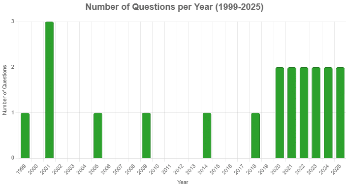
From 1999 to 2025, 20 questions with varying difficulty have been asked: 6 easy (30%), 10 medium (50%), and 4 hard (20%)— emphasis is generally on Earth’s processes, geological structures, and rock systems.

From 1999 to 2025, 20 questions with varying difficulty have been asked: 6 easy (30%), 10 medium (50%), and 4 hard (20%)— emphasis is generally on Earth’s processes, geological structures, and rock systems.
Q1: Which of the following are the evidences of the phenomenon of continental drift? (2025)
I. The belt of ancient rocks from Brazil coast matches with those from Western Africa.
II. The gold deposits of Ghana are derived from the Brazil plateau when the two continents lay side by side.
III. The Gondwana system of sediments from India is known to have its counterparts in six different landmasses of the Southern Hemisphere.
Select the correct answer using the code given below.
(a) I and III only
(b) I and II only
(c) I, II and III
(d) II and III only
 View Answer
Correct Answer is Option (c) I, II and III
All three statements are valid evidences supporting the Continental Drift Theory proposed by Alfred Wegener.
Q2: Consider the following statements: (2025)
Statement I: In the context of effect of water on rocks, chalk is known as a very permeable rock whereas clay is known as quite an impermeable or least permeable rock.
Statement II: Chalk is porous and hence can absorb water.
Statement III: Clay is not at all porous.
Which one of the following is correct in respect of the above statements?
(a) Both Statement II and Statement III are correct and both of them explain Statement I
(b) Both Statement II and Statement III are correct but only one of them explains Statement I
(c) Only one of the Statements II and III is correct and that explains Statement I
(d) Neither Statement II nor Statement III is correct
 View Answer
Correct Answer is Option (c)
Statement I: Correct. Chalk is highly permeable; clay is nearly impermeable.
Statement II: Correct. Chalk’s porosity allows it to absorb water, explaining its high permeability in Statement I.
Statement III: Incorrect. Clay is porous but has tiny, poorly connected pores, making it impermeable, not “not at all porous.”
Q3: Consider the following: (2024)
(i) Pyroclastic debris
(ii) Ash and dust
(iii) Nitrogen compounds
(iv) Sulphur compounds
How many of the above are products of volcanic eruptions?
(a) Only one
(b) Only two
(c) Only three
(d) All four
 View Answer
Correct Answer is Option (d)
All four of the listed substances are products of volcanic eruptions:
Thus, the correct answer is Option D (All four).
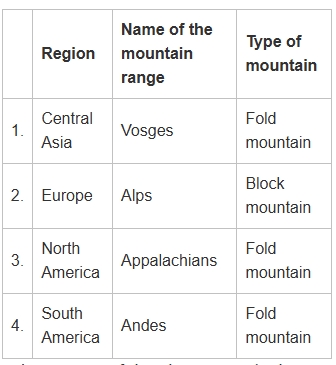
Q4: Consider the following information: (2024) In how many of the above rows is the given information correctly matched?
(a) Only one
(b) Only two
(c) Only three
(d) All four
 View Answer
Correct Answer is Option (b)
So, two rows are correctly matched (rows 3 and 4), not just one. Hence, the correct answer is Option B (Only two).
Q5: Which one of the following is the best example of repeated falls in sea level, giving rise to present-day extensive marshland? (2023)
(a) Bhitarkanika Mangroves
(b) Marakkanam Salt Pans
(c) Naupada Swamp
(d) Rann of Kutch
 View Answer
Correct Answer is Option (d)
The Rann of Kutch is the best example of repeated falls in sea level, giving rise to extensive marshland. It is a large, salt marshy area located in the Kutch district of Gujarat. Over the centuries, the region has experienced repeated fluctuations in sea level, leading to the formation of the Rann, a seasonal marshland that is submerged during the monsoon season and becomes dry and cracked during the dry season. The phenomenon is linked to tectonic activity and changes in sea levels.
The other options are not as closely related to the phenomenon of repeated sea level fluctuations:
Q6: Ilmenite and rutile, abundantly available in certain coastal tracts of India, are rich sources of which one of the following? (2023)
(a) Aluminium
(b) Copper
(c) Iron
(d) Titanium
 View Answer
Correct Answer is Option (d)
Ilmenite and rutile are both important ores of titanium. These minerals are rich in titanium dioxide (TiO2) and are primarily used in the production of titanium metal and its compounds. India has significant deposits of ilmenite and rutile, particularly along its coastal regions, which are mined for their titanium content.
Q7: Gandikota canyon of South India was created by which one of the following rivers? (2022)
(a) Cauvery
(b) Manjira
(c) Pennar
(d) Tungabhadra
 View Answer
Correct Answer is Option (c)
The Gandikota Canyon, often referred to as the "Grand Canyon of India," was created by the Pennar River. The river has carved deep gorges and valleys through the rugged terrain of the Eastern Ghats, forming this spectacular canyon located in the Kadapa district of Andhra Pradesh.
The other rivers mentioned are not responsible for the formation of Gandikota Canyon:
Thus, the correct answer is Option C (Pennar).
Q8: With reference to India, consider the following statements? (2022)
1. Monazite is a source of rare earths.
2. Monazite contains thorium.
3. Monazite occurs naturally in the entire Indian coastal sands in India.
4. In India, Government bodies only can process or export monazite.
Which of the statements given above are correct?
(a) 1, 2 and 3 only
(b) 1, 2 and 4 only
(c) 3 and 4 only
(d) 1, 2, 3 and 4
 View Answer
Correct Answer is Option (b)
Thus, the correct answer is Option B (1, 2, and 4 only).
Q9: The black cotton soil of India has been formed due to the weathering of (2021)
(a) brown forest soil
(b) fissure volcanic rock
(c) granite and schist
(d) shale and limestone
 View Answer
Correct Answer is Option (b)
The black cotton soil of India, also known as Regur soil, is primarily formed due to the weathering of fissure volcanic rock, which is rich in iron and magnesium. These soils are found in regions where volcanic eruptions have occurred, particularly in areas like Maharashtra, Madhya Pradesh, and Gujarat. The volcanic rocks, when weathered, break down to form a rich, dark-colored soil that is highly fertile and ideal for growing cotton, hence the name "black cotton soil." Option B (fissure volcanic rock) is the correct answer because this type of rock, when weathered, produces the characteristic black cotton soil.
Q10: Consider the following rivers: (2021)
1. Brahmani
2. Nagavali
3. Subarnarekha
4. Vamsadhara
Which of the above rise from the Eastern Ghats?
(a) 1 and 2
(b) 2 and 4
(c) 3 and 4
(d) 1 and 3
 View Answer
Correct Answer is Option (b)
On the other hand, Brahmani and Subarnarekha originate from different regions:
Thus, the correct answer is Option B (2 and 4).
Q11: Siachen Glacier is situated to the (2020)
(a) East of Aksai Chin
(b) East of Leh
(c) North of Gilgit
(d) North of Nubra Valley
 View Answer
Correct Answer is Option (d)
The Siachen Glacier is located in the Karakoram Range in the northern part of India and is situated north of the Nubra Valley in Ladakh. The glacier lies at an elevation of about 5,400 meters (17,700 feet) above sea level and is the largest glacier in the world outside the polar regions.
Q12: Consider the following pairs (2020) Which of the pairs given above is/are correctly matched?
(a) 1 and 2 only
(b) 3 only
(c) 3 and 4 only
(d) 1, 2 and 4 only
 View Answer
Correct Answer is Option (c)
Thus, the only correct pairs are 3 (Volga-Caspian Sea) and 4 (Zambezi-Indian Ocean).
Q13: Consider the following statements: (2018-I)
Which of the statements given above is/are correct?
(a) 1 only
(b) 2 and 3
(c) 3 only
(d) 1 and 3
 View Answer
Correct Answer is Option (a)
Barren Island volcano became active again in March 1991. The second phase of eruptions started in 1995. So it means the third statement is wrong, by elimination, we have the answer (a) only 1.
Q14: Which of the following phenomena might have influenced the evolution of organisms? (2014 - I)
Select the correct answer using the code given below.
(a) 1 only
(b) 2 only
(c) Both 1 and 2
(d) Neither 1 nor 2
 View Answer
Correct Answer is Option (c)
Continental Drift has affected the evolution of animals, the world's geographical positions, and the world's climates. The split of the original super landmass Pangea into Gondwanaland and the Laurasia created new geographical/ climatic regions. The rearrangement and displacement of huge landmasses have helped create the diversity which we see in modern-day species. The final stages of evolution of Genus Homo occur in the last 3 glacial cycles.
Q15: In the structure of planet Earth, below the mantle, the core is mainly made up of which one of the following? (2009)
(a) Aluminium
(b) Chromium
(c) Iron
(d) Silicon
 View Answer
Correct Answer is Option (c)
The core of the earth is made up of nickle and iron.
Q16: Where is the volcanic mountain, Mount St. Helens located? (2005)
(a) Chile
(b) Japan
(c) Philippines
(d) United States of America
 View Answer
Correct Answer is Option (d)
Volcanic mountain. St. Helen is located in United States of America.
Q17: Quartzite is metamorphosed from: (2001)
(a) limestone
(b) obsidian
(c) sandstone
(d) shale
 View Answer
Correct Answer is Option (c)
Quartzite is a metamorphosed form of sandstone.
Q18: Volcanic eruptions do not occur in: (2001)
(a) Baltic Sea
(b) Black Sea
(c) Caribbean Sea
(d) Caspian Sea
 View Answer
Correct Answer is Option (a)
The basaltic rock found in the Baltic sea is transported by glaciers.
Q19: Consider the following statements made about sedimentary rocks: (2001)
Which of these statements are correct?
(a) 1 and 2
(b) 1 and 4
(c) 2, 3 and 4
(d) 1, 2, 3 and 4
 View Answer
Correct Answer is Option (d)
All the statements are true about the sedimentary rock.
Q20: Which one of the following types of coal contains a higher percentage of carbon than the rest? (1999)
(a) Bituminous coal
(b) Lignite
(c) Peat
(d) Anthracite
 View Answer
Correct Answer is Option (d)
Anthracite is a dense, shiny coal that has a high carbon content. Very little volatile matter is present in it. It gives a clean flame while burning. Anthracite contains 91% of carbon; is very little volatile and has almost smokeless burning.
|
175 videos|619 docs|192 tests
|
| 1. What is geomorphology and why is it important in the UPSC exam? |  |
| 2. What are the major landforms studied in geomorphology? |  |
| 3. How do tectonic processes influence geomorphology? |  |
| 4. What role do rivers play in geomorphological processes? |  |
| 5. How can knowledge of geomorphology help in disaster management? |  |