Geography: July 2022 Current Affairs - UPSC PDF Download
| Table of contents |

|
| Heat Index |

|
| Azores High |

|
| Eu’s Palm Oil Row With Malaysia and Indonesia |

|
| Coastal Erosion |

|
| Aridity Anomaly Outlook Index |

|
| Sakurajima Volcano: Japan |

|
Heat Index
Why in News?
Recently, the temperature of Delhi felt like 52 degrees C (on Heat Index) even though the actual temperature was 39 degrees C, mainly because of high humidity and lack of rain
What are Heatwaves?
- A heatwave is a period of abnormally high temperatures, more than the normal maximum temperature that occurs during the summer season in the North-Western and South Central parts of India.
- Heatwaves typically occur between March and June, and in some rare cases even extend till July.
- India Meteorological Department (IMD) classifies heatwaves according to regions and their temperature ranges.
What is the Criteria for Heatwaves?
- The heatwave is considered when the maximum temperature of a station reaches at least 40°C for Plains and at least 30°C for Hilly regions.
- If the normal maximum temperature of a station is less than or equal to 40°C, then an increase of 5°C to 6°C from the normal temperature is considered to be heat wave condition.
- Further, an increase of 7°C or more from the normal temperature is considered a severe heat wave condition.
- If the normal maximum temperature of a station is more than 40°C, then an increase of 4°C to 5°C from the normal temperature is considered to be heat wave condition. Further, an increase of 6°C or more is considered a severe heat wave condition.
- Additionally, if the actual maximum temperature remains 45°C or more irrespective of normal maximum temperature, a heat wave is declared.
Why is Humidity such a Critical factor while Measuring Heat Exposure?
- Humans lose heat generated within their bodies by producing sweat that evaporates on the skin.
- The cooling effect of this evaporation is essential in maintaining a stable body temperature.
- As humidity rises, sweat does not evaporate and makes it difficult to regulate body temperature. This is why humans feel more discomfort in humid places.
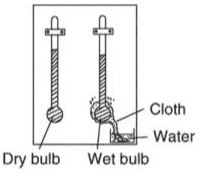
- The wet bulb temperature is usually lower than the dry bulb temperature, and the difference between the two increases dramatically as the air becomes dry.

What is the Wet Bulb Temperature?
- Wet bulb temperature is the lowest temperature to which air can be cooled by the evaporation of water into the air at a constant pressure.
- WBT is a limit that considers heat and humidity beyond which humans can not tolerate high temperatures.
- The Wet Bulb temperature is the temperature of adiabatic saturation. This is the temperature indicated by a moistened thermometer bulb exposed to the air flow.
- An adiabatic process is one in which no heat is gained or lost by the system.
- Wet Bulb temperature can be measured by using a thermometer with the bulb wrapped in wet muslin.

- The wet bulb temperature is always lower than the dry bulb temperature but will be identical with 100% relative humidity (the air is at the saturation line).
Azores High
Why in News?
Recently, a study revealed that an extremely large ‘Azores High’ (a subtropical weather phenomenon) has resulted in abnormally dry conditions across the western Mediterranean, including the Iberian Peninsula, primarily occupied by Spain and Portugal.
What do we mean by Azores High?
- About:
- Azores High is a subtropical high pressure system that extends over the eastern subtropical North Atlantic and western Europe during winter.
- It is associated with anticyclonic winds in the subtropical North Atlantic.
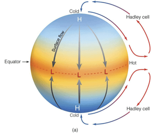
- It is formed by dry air aloft descending the subtropics and coincides with the downward branch of the Hadley Circulation.
- Hadley Circulation:
- Hadley Cells are the low-latitude overturning circulations that have air rising at the equator and air sinking at roughly 30° latitude.
- They are responsible for the trade winds in the Tropics and control low-latitude weather patterns.
- Hadley cells could extend all the way to the poles.

Why are Azores High Expanding?
- The Azores High expansion is driven by external climate forces and that the only external forcing that produces this signal in the industrial era is atmospheric greenhouse gas concentrations.
- Azores High expansion emerged after 1850 and strengthened in the twentieth century, consistent with anthropogenically driven warming.
- The researchers explored the changing atmospheric conditions since the onset of the industrial era that contributed to these regional hydroclimatic changes by assessing how the characteristics of the Azores High varied over the past 1,200 years.
Since Azores High are a part of Atmospheric circulation , to read more information on such topic:
- Revision Notes - Atmospheric Circulation and Weather Systems - 1
- Revision Notes - Atmospheric Circulation and Weather Systems - 2
Eu’s Palm Oil Row With Malaysia and Indonesia
Context
- Indonesia and Malaysia claim the EU’s palm oil restrictions are unfair and “discriminatory,” and they are hoping for a WTO resolution.
- Meanwhile, the EU has imposed new restrictions on the use of palm oil as a fuel.
The Import and the complaint
- According to Indonesian government data, EU imports from Indonesia increased by 9 percent last year compared to 2020.
- The World Trade Organization (WTO) may soon rule on two cases filed against the European Union in connection with its decision to phase out the import of unsustainable palm oil by 2030.
- The complaints were lodged by Indonesia and Malaysia, the world’s two largest palm oil producers, who denounced Brussels’ Renewable Energy Directive II as unfair and “discriminatory.”
EU’s Objection
- On the contentious issue, the EU has sent mixed signals.
- On the one hand, its officials have stated unequivocally that oil production is a major cause of deforestation and thus cannot meet renewable energy targets.
- There is also the issue of pollution: palm oil diesel emits up to three times the amount of pollution as traditional petroleum-based fuel.
- The Ukraine war, which began in February of this year, increased pressure on Brussels to secure its fuel supply.
ReFuelEU Initiative
- Early in July, EU lawmakers approved draught rules for the ReFuelEU initiative, which would require that 85 percent of all used aviation fuel be “sustainable” by 2050. Byproducts of palm oil would be unacceptable.
- The European Parliament is now discussing bringing forward the final phase-out date for palm oil imports, which is currently set at 2030.
- Simultaneously, Brussels has attempted to engage with palm oil exporters in recent months, including at the ASEAN-EU Joint Cooperation Committee meeting in Jakarta in late June.
Malaysia decries ‘crop apartheid’
- The Malaysian and Indonesian governments have also tried to keep their options open in the EU row.
- Earlier this year, Malaysian Minister of Plantation Industries and Commodities Zuraida Kamaruddin slammed what she called “crop apartheid.”
- And with the dispute ongoing, the Malaysian government is busy finding new markets.
What if the WTO rules against the EU?
- The WTO decision seems to be drawing near.
- The panel to decide Indonesia’s case was formed in November 2020.
- A panel of the same members was formed for Malaysia’s case in July 2021. Both are chaired by Manzoor Ahmad, Pakistan’s former permanent representative to the WTO. Members are Sarah Paterson, of New Zealand, and Arie Reich, of Israel.
- If the WTO panels were to rule against in favor of Indonesia and Malaysia, Brussels has three options
- First, the EU could appeal against the panel report. But that could set back a final ruling by years, as any decision would have to come after new members are appointed to the WTO’s Appellate Body. The body is currently not functioning due to the US blocking new appointees.
- The second option, Mayr noted, would be for the EU to comply with the WTO ruling and adapt the environmental policies established by the Renewable Energy Directive II. Whether the EU could make cosmetic changes to its palm oil phase-out, while keeping the essence of the policy, is unclear.
- Lastly, the EU could simply carry on regardless and accept any retaliatory measures imposed by Indonesia and Malaysia.
- This last option, however, doesn’t seem too likely.
Geopolitics and palm oil
- If the EU was to ignore the ruling, Indonesia and Malaysia would struggle to retaliate economically, analysts reckon. According to European Commission data, Malaysia is only the EU’s 20th largest trading partner in goods; Indonesia is 31st.
- Because of the energy crisis caused by the Ukraine war, the official also expects EU imports of palm oil to continue growing in the coming years.
- Moreover, Jakarta has one more card to play — it could limit the export of raw materials necessary for the production of stainless steel. (The EU brought a case against Indonesia to the WTO regarding this in November 2019.)
Palm Oil and Its Uses
- Palm oil is an edible vegetable oil derived from the mesocarp (reddish pulp) of oil palm fruit.
- It is used as a cooking oil as well as in cosmetics, processed foods, cakes, chocolates, spreads, soaps, shampoo, and cleaning products, as well as biofuel.
- The use of crude palm oil in the production of biodiesel is dubbed “green diesel.”
What Role Does Palm Oil Play in Global Supply Chains?
- According to the United States Department of Agriculture, palm oil is the world’s most widely used vegetable oil, with a global production of over 73 Million Tonnes (MT) in 2020. (USDA).
- It is expected to be 77 MT for the fiscal year 2022-23.
- Reuters reports that palm oil accounts for 40% of the global supply of the four most widely used edible oils: palm, soybean, rapeseed (canola), and sunflower oil.
- Indonesia accounts for 60 percent of the global supply of palm oil.
Why are edible oil prices rising?
- India is the world’s largest importer of palm oil. Palm oil prices rose this year as demand increased due to a scarcity of alternative vegetable oils.
- Soybean oil production, the second most-produced oil, is expected to fall this year due to a poor soybean season in major producer Argentina.
- Drought harmed canola oil production in Canada last year, and the ongoing conflict has harmed supplies of sunflower oil, 80-90 percent of which is produced by Russia and Ukraine.
What Will It Mean for India?
- India is the largest importer of palm oil, accounting for 40% of its vegetable oil consumption.
- India imports half of its annual requirement of 8.3 MT of palm oil from Indonesia.
- This would exacerbate those already dealing with record-high wholesale inflation.
- It is also worth noting that the Centre launched the National Mission on Edible Oil-Oil Palm last year in order to increase India’s domestic palm oil production.
Coastal Erosion
Context: As per the Ministry of Earth Science (MoES) 34% of India’s coastline is under erosion. West Bengal has suffered the worst (60.5% of its coast is threatened by erosion).
What is Coastal Erosion?
About:
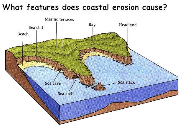
- Coastal erosion is the process by which local sea level rise, strong wave action, and coastal flooding wear down or carry away rocks, soils, and/or sands along the coast.
- Erosion and Accretion: Erosion and accretion are complementary to each other. If the sand and sediments have drifted from one side, it must accumulate somewhere else.
- Soil erosion is the loss of land and human habitation as sea water washes off regions of soil along the coastline.
- Soil accretion, on the other hand, results in an increase in the land area.
Impact:
- Recreational activities (sun bathing, picnicking, swimming, surfing, fishing, boating, diving, etc.) may be affected if existing beaches are reduced in width or disappear altogether. Also, there can be an impact on livelihoods of coastal communities.
Measures:
- Coastal habitats such as Mangroves, Coral Reefs and lagoons are recognized as the best defence against sea storms and erosion, deflecting and absorbing much of the energy of sea storms. Therefore, it is important to maintain these natural habitats for shore protection as well as for environmental conservation.

What are the Factors causing Coastal Erosion?
- Natural Phenomena:
- Wave energy is considered to be the primary reason for coastal erosion.
- Natural hazards like cyclones, thermal expansion of seawater, storm surges, tsunami etc due to the melting of continental glaciers and ice sheets as a result of climate change hamper the natural rhythm and precipitate erosion.
- Littoral Drift:
- Strong littoral drift resulting in sand movement can also be considered as one of the major reasons for coastal erosion.
(I) Littoral drift means the natural movement of sediment along marine or lake shorelines by wave action in response to prevailing winds.
- Strong littoral drift resulting in sand movement can also be considered as one of the major reasons for coastal erosion.
- Anthropogenic Activities:
- Dredging, sand mining and coral mining have contributed to coastal erosion causing sediment deficit, modification of water depth leading to longshore drift and altered wave refraction.
(i) Coastal erosion has been sparked by fishing harbours and dams constructed in the catchment area of rivers and ports reducing the flow of sediments from river estuaries.
- Dredging, sand mining and coral mining have contributed to coastal erosion causing sediment deficit, modification of water depth leading to longshore drift and altered wave refraction.
What are the Methods for Coastal Protection?
- Artificial Beach Nourishment
- Protective Structures: Seawalls, Revetments.
- Structures to Trap Sediment Movement.
- Combination of Artificial Beach Nourishment & Structures.
- Control of Beach Groundwater Table or Beach Dewatering System.
- Vegetation Planting.
- Use of Geo-synthetic Tubes / Bags.
Way Forward
- The XVth Finance Commission had suggested, The National Disaster Management Authority (NDMA) and/or Ministry of Home Affairs may develop suitable norms for mitigation measures to prevent erosion and both the Union and the State Governments develop a policy to deal with the extensive displacement of people caused by coastal and river erosion.
- The Commission has also made specific recommendations for ‘Mitigation Measures to Prevent Erosion’ under NDMF (National Disaster Mitigation Fund) and ‘Resettlement of Displaced People Affected by Erosion’ under NDRF (National Disaster Response Fund).
Since Coastal erosion are a part of Coastal landforms, so to read more information on such topic :
Aridity Anomaly Outlook Index
Why in News?
- Recently, Indian Meteorological Department (IMD) has released the Aridity Anomaly Outlook (AAO) Index of July 2022, which says at least 85% of districts face arid conditions across India.
What is the Aridity Anomaly Outlook Index?
- About:
- The index monitors agricultural drought, a situation when rainfall and soil moisture are inadequate to support healthy crop growth till maturity, causing crop stress.
- An anomaly from the normal value signifies a water shortage in these districts that could directly impact agricultural activity.
- It is Developed by the India Meteorological Department (IMD).
- Characteristics:
- A real-time drought index in which water balance is considered.
- The Aridity Index (AI) is computed for weekly or two-week periods.
(i) For each period, the actual aridity for the period is compared to the normal aridity for that period. - Negative values indicate a surplus of moisture while positive values indicate moisture stress.
- Parameters:
- Actual evapotranspiration and calculated potential evapotranspiration, which require temperature, wind and solar radiation values.
(i) Actual evapotranspiration is the quantity of water that is actually removed from a surface due to the processes of evaporation and transpiration.
(ii) Potential evapotranspiration is the maximum attainable or achievable evapotranspiration for a given crop due to evaporation and transpiration.
- Actual evapotranspiration and calculated potential evapotranspiration, which require temperature, wind and solar radiation values.
- Applications:
- Impacts of drought in agriculture, especially in the tropics where defined wet and dry seasons are part of the climate regime.
- Both winter and summer cropping seasons can be assessed using this method.
What are the Findings?
- Only 63 of 756 districts are non-arid, while 660 are facing different degrees of aridity — mild, moderate and severe.
- Some 196 districts are in the grip of a ‘severe’ degree of dryness and 65 of these are in Uttar Pradesh (highest).
- Bihar had the second highest number of districts (33) experiencing arid conditions. The state also has a high rainfall deficit of 45%.
- Other districts facing ‘severe arid’ conditions are Jharkhand, Haryana, Madhya Pradesh, Delhi, Telangana, Maharashtra, Andhra Pradesh, Jammu and Kashmir, Punjab, West Bengal, Rajasthan, Karnataka and Tamil Nadu.
- The SPI on the DEWS platform also highlights a persisting rainfall deficit in these areas in the last six months.
- Arid conditions have impacted the ongoing Kharif sowing, as the area sown under different kharif crops as of July, 2022, was less by 13.26 million hectares compared to the corresponding period in 2021.
What is the Standardised Precipitation Index (SPI)?
- The SPI is a widely used index to characterize meteorological drought on a range of timescales.
- On short timescales, the SPI is closely related to soil moisture, while at longer timescales, the SPI can be related to groundwater and reservoir storage.
- The SPI on the Drought Early Warning System (DEWS), a real-time drought monitoring platform managed by the Indian Institute of Technology, Gandhinagar (IIT-G) platform highlights a persisting rainfall deficit in these areas in the last six months.
- UP, Jharkhand, Bihar, West Bengal and some parts of the North East are under extreme drought situation and agriculture of these regions might be affected.
Sakurajima Volcano: Japan
Why in News?
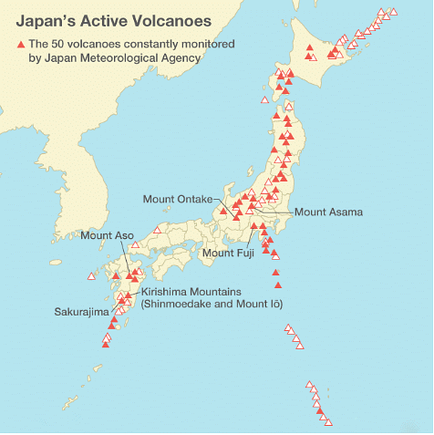
Recently, the Sakurajima Volcano erupted on Japan’s major western island of Kyushu.
In 2021, the Fukutoku-Okanoba Submarine Volcano exploded in the Pacific Ocean, off Japan.
What is Sakurajima Volcano?
- Sakurajima is one of Japan’s most active volcanoes and eruptions of varying levels take place on a regular basis.
- It is an active stratovolcano.
- The largest historical eruptions of Sakurajima took place during 1471-76 and in 1914.
What is a Volcano?
- About:
- A volcano is an opening on the surface of a planet or moon that allows material warmer than its surroundings to escape from its interior.
- Reasons for Magma Rise:
- Magma can rise when pieces of Earth's crust called tectonic plates slowly move away from each other. The magma rises to fill in the space. When this happens, underwater volcanoes can form.
- Magma also rises when these tectonic plates move toward each other. When this happens, part of Earth's crust can be forced deep into its interior. The high heat and pressure cause the crust to melt and rise as magma.
Types
- Shield volcanoes:
- A volcano produces low viscosity, runny lava, it spreads far from the source and forms a volcano with gentle slopes.
- Most shield volcanoes are formed from fluid, basaltic lava flows.
(i) Mauna Kea and Mauna Loa are shield volcanoes. They are the world’s largest active volcanoes around the island of Hawai’i.
- Stratovolcano:
- Stratovolcanoes have relatively steep sides and are more cone-shaped than shield volcanoes.
- They are formed from viscous, sticky lava that does not flow easily.
- Lava dome:
- The Soufrière Hills volcano, on the Caribbean island of Montserrat, is well known for its lava dome complex at the summit of the volcano, which has gone through phases of growth and collapse. As viscous lava is not very fluid, it cannot flow away from the vent easily when it is extruded. Instead it piles up on top of the vent forming a large, dome-shaped mass of material.
- Caldera:
- Magma is stored beneath a volcano in a magma chamber. When a very large, explosive eruption occurs that empties the magma chamber, the roof of the magma chamber can collapse to form a depression or bowl with very steep walls on the surface.
- These are calderas and can be tens of miles across.
What about the Volcanoes in India?
- Barren Island, Andaman Islands (India's only active volcano)
- Narcondam, Andaman Islands
- Baratang, Andaman Islands
- Deccan Traps, Maharashtra
- Dhinodhar Hills, Gujarat
- Dhosi Hill, Haryana
To read more information on Volcanoes
FAQs on Geography: July 2022 Current Affairs - UPSC
| 1. What is the heat index and how is it calculated? |  |
| 2. What is the Azores High and how does it affect weather patterns? |  |
| 3. What is the ongoing palm oil row between the EU, Malaysia, and Indonesia? |  |
| 4. What are the causes and consequences of coastal erosion? |  |
| 5. What is the Aridity Anomaly Outlook Index and how is it used in climate monitoring? |  |


