UPSC Exam > UPSC Notes > Geography for UPSC CSE > GC Leong: Summary of Coastal Landforms
GC Leong: Summary of Coastal Landforms | Geography for UPSC CSE PDF Download

Coastal Features of Erosion
1. Capes & Bays
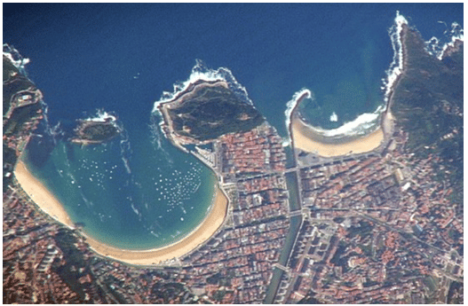
- On exposed coasts, the continual action of waves on the rocks of varying resistance causes the coastline to be eroded irregularly.
- This is particularly pronounced where hard rocks occur in alternate band with softer rocks.
- The softer rocks are worn back into inlets or bays & the harder ones persist as headlands or capes.
- Even where the coastline consists of one rock type, irregularities will be caused by variations within the rock.
2. Cliffs & Wave Cut platforms
- Cliff is a steep rock facing the adjoining coast.
- The rate of recession depends on geological structure (stratification, jointing and resistance to wave attack).
- If the bed dips seaward, large blocks of rock will be dislodged & fall into the sea & cliff will rise in a series of steps.
- On the other hand, if the beds dip landward, the cliff will be more resistant to wave erosion.
- At the base of the cliff, the sea cuts a notch, which gradually undermines the cliff, so that it collapses.
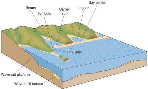
- As the cliff recedes landwards under the pounding of waves, an eroded base is left behind called a wave-cut platform.
- The platform, the upper part of which is exposed at low tides, slopes gently seawards, with its surface strewn with rock debris from the receding cliff.
- Further, the abrasion continues until the pebbles are swept away in the sea with eroded material deposited on off shore terrace.
3. Cave, Arch, Stack & Stump
- Wave erosion creates caves in cliff bases where there are weak spots, like at Flamborough Head, England.
- When caves on opposite sides of a headland merge, they form an arch, such as the Neddie Eye near Wick, Scotland.
- Continued wave erosion causes the eventual collapse of the arch.
- The remaining seaward portion of the headland becomes a stack, like the Old Man of Hoy in the Orkneys, which stands at 450 feet.
- Notable examples of stacks are the Needles, Isle of Wight, composed of chalk and decreasing in size towards the sea.
- Over time, stacks erode further until they become stumps, like those off the St. Kilda group, Outer Hebrides, Scotland.
4. Geos & Gloups (blow-holes)
- The occasional splashing of the waves against the roof of a cave may enlarge the joints when air is compressed & released repeatedly inside them.
- A natural shaft is thus formed which may eventually pierce through the surface.
- Waves breaking into the cave may force water or air out of this hole. Such a shaft is termed as Gloup or blow hole.
- The enlargement of blow-holes & continual action of waves weakens the cave roof.
- When the cave roof collapses, a long, narrow creek may develop known as Geos.
Coastal Features of Deposition
1. Beaches
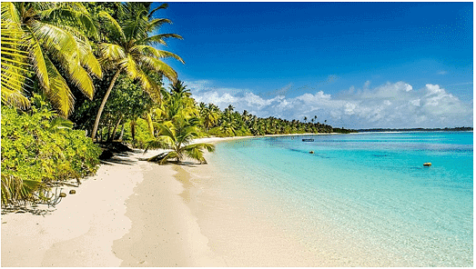
- Sands & gravel loosened from the land are moved by waves to be deposited along the shore as beaches.
- The eroded material is transported along the shore in several distinct ways.
- Long shore drifts which comes obliquely to the coast carries material along the shore in the direction of the dominant wind.
- At the same time, backwash removes part of the material seawards, along the bed of the sea, & deposits it on the off-shore terrace & even beyond.
- The constant action of the waves automatically sorts out the shoreline deposits in a graded manner.
- The coarser materials are dropped by the waves at the top of the beaches & the finer materials, carried down the beach by the backwash, are dropped closer to the sea.
2. Spits & Bars
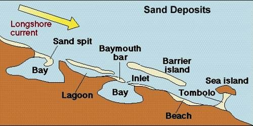
- The debris eroded by waves is continually moved by long shore drift & where there is an indentation in the coast, such as at the mouth of the river or a bay; material may continue to be deposited across the inlet.
- As more materials are added, they will pile up into a ridge or embankment of shingle forming a spit, with one end attached to the land & other projecting into the sea.
- When a ridge of shingle is formed across the mouth of a river or the entrance to a bay, it is called a bar.
- Such a connecting bar that joins two land masses is known as Tombolo.
3. Marine Dunes & Dune Belts
- With the force of on-shore winds, a large amount of coastal sand is driven landwards forming extensive marine dunes that stretches into dune belts.
- Their advance inland may engulf farms, roads & even the entire villages;
- Hence to arrest the migration of dunes, sand-binding species of grass & shrubs, such as marram grass & pines are planted.
Types of Coasts
Despite a great variety of coastal features, coastlines may be divided into two basic types: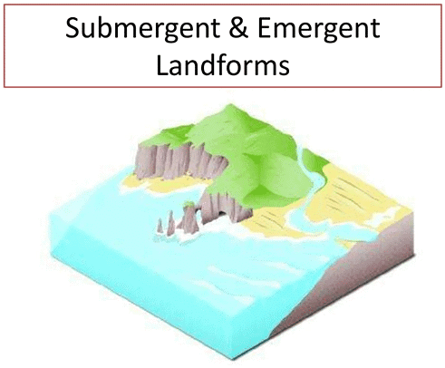
1. Coastline of Submergence
- Formed due to the sinking of the land or the rise of the sea.
- Including such coasts are Ria coasts, Fjord coasts, Estuarine coasts & Dalmatian/Longitudinal coasts.
2. Coastline of Emergence
- Formed due to the uplift of the land or fall in the sea level.
- Generally less common & include uplifted low land coast & emergent upland coast.
Coastline of Submergence
1. Ria Coasts - Drowned river valleys
- During the ice age, a great deal of water was locked up in the ice, which melted as the climate got warmer leading to increase in sea level.
- In upland coastal regions, where the mountain runs at a right angle to the sea i.e. transversely to the coast, a rise in the sea level submerges or drowns the lower parts of the valleys to form long narrow branching inlets separated by narrow headlands.
- Hence, a raise a coastal inlet formed by the partial submergence of an unglaciated river valley that remains open to the sea & is a coastline having several parallel rias separated by prominent ridges, extending a distance inland.
- The drowning of river valleys along a stretch of coast and the formation of rias results in an extremely irregular and indented coastline.
- A ria coast differs from the fiords in two ways viz. they are not glaciated, & their depth increases seaward.
- All rias are generally backed by highlands & support few large commercial ports & extensively used for sitting fishing ports & naval bases.
2. Fjord coasts - Drowned glaciated valleys
- Fjords were created by glaciers that moved very slowly over time, and greatly altered the landscape once they have moved through an area carving deep valley.
- The above process is called glaciation.
- Fjord is formed when a glacier retreats, after carving its typical U-shaped valley with the sea filling the resulting valley floor.
- It forms a narrow, steep-sided inlet connected to the sea
- The terminal moraine pushed down the valley by the glacier is left underwater at the fjord’s entrance.
- It causes the water at the neck or mouth of the fjord to be shallower than the main body of the fjord behind it.
- Hence the opening toward the sea is often shallow & termed as threshold.
3. Dalmatian coasts
- A longitudinal coast where the mountains run parallel to the coast
- Where the submergence of the coastline produces long, narrow inlets with a chain of islands parallel to the coast.
- The elongated islands are the crests of former ranges & the narrow inlets were the former longitudinal valleys.
- Like Ria and fjord coasts, the mountainous nature of Dalmatian coastline hinders inland communication.
4. Estuarine Coasts
- Estuarine coasts are basically the coasts made by estuaries, with streams of river freely flowing into the sea, making them excellent sites for the ports.
- An estuary is a partly enclosed coastal body of brackish water (salinity in between saline sea water & fresh river water) with one or more rivers or streams flowing into it, and with a tree connection to the open sea.
- Estuaries form a transition zone between river environments and maritime environments.
- They are subject both to marine influences—such as tides, waves, and the influx of saline water—and to riverine influences—such as flows of fresh water and sediment.
COASTLINE OF EMERGENCE
1. Uplifted lowland coasts
- The uplifted part of the continental self produces gently sloping coastal lowland.
- The offshore waters are shallow with lagoons, salt marshes & mudflats.
- Where the emerging deposits from the continental shelf are sandy & gravelly, beaches & marine dunes are formed.
- Ports that were once located on the former coast, became inland towns.
2. Emergent upland coasts
- Faulting & earth movement may thrust up coastal plateaus so that whole region is raised forming a raised beach.
- A raised beach is beyond the range of waves, though it may still possess arches, stacks & other coastal features.
- The emergent upland coast is quite straight with steep cliffs & deeper off shore waters.
The document GC Leong: Summary of Coastal Landforms | Geography for UPSC CSE is a part of the UPSC Course Geography for UPSC CSE.
All you need of UPSC at this link: UPSC
|
175 videos|624 docs|192 tests
|
FAQs on GC Leong: Summary of Coastal Landforms - Geography for UPSC CSE
| 1. What are some examples of coastal features of erosion? |  |
Ans. Some examples of coastal features of erosion include sea cliffs, sea caves, blowholes, and wave-cut platforms.
| 2. Can you provide some examples of coastal features of deposition? | |
Ans. Some examples of coastal features of deposition include beaches, spits, tombolos, barrier islands, and deltas.
| 3. What are the different types of coasts mentioned in the article? | |
Ans. The different types of coasts mentioned in the article are primary coasts, secondary coasts, and tertiary coasts.
| 4. How do coastal features of erosion and deposition contribute to the formation of various landforms along the coast? | |
Ans. Coastal features of erosion, such as sea cliffs and sea caves, create unique landforms through the process of wearing away rock and sediment. Coastal features of deposition, such as beaches and barrier islands, contribute to the formation of new landforms by depositing sediment in certain areas.
| 5. What role do factors like tides, waves, and currents play in shaping coastal landforms? | |
Ans. Factors like tides, waves, and currents are instrumental in shaping coastal landforms by constantly moving and reshaping sediment along the coast. Tides and waves erode the coastline, while currents transport sediment and deposit it in various locations, ultimately influencing the formation of coastal landforms.
About this Document

2.5K Views

4.61/5
Rating

Sep 21, 2025
Last updated
Related Exams
Document Description: GC Leong: Summary of Coastal Landforms for UPSC 2025 is part of Geography for UPSC CSE preparation.
The notes and questions for GC Leong: Summary of Coastal Landforms have been prepared according to the UPSC exam syllabus. Information about GC Leong: Summary of Coastal Landforms covers topics
like Coastal Features of Erosion, Coastal Features of Deposition, Types of Coasts and GC Leong: Summary of Coastal Landforms Example, for UPSC 2025 Exam. Find important definitions, questions, notes, meanings, examples, exercises and tests below for GC Leong: Summary of Coastal Landforms.
Introduction of GC Leong: Summary of Coastal Landforms in English is available as part of our Geography for UPSC CSE
for UPSC & GC Leong: Summary of Coastal Landforms in Hindi for Geography for UPSC CSE course.
Download more important topics related with notes, lectures and mock test series for UPSC
Exam by signing up for free. UPSC: GC Leong: Summary of Coastal Landforms | Geography for UPSC CSE
Description
Full syllabus notes, lecture & questions for GC Leong: Summary of Coastal Landforms | Geography for UPSC CSE - UPSC | Plus excerises question with solution to help you revise complete syllabus for Geography for UPSC CSE | Best notes, free PDF download
Information about GC Leong: Summary of Coastal Landforms
In this doc you can find the meaning of GC Leong: Summary of Coastal Landforms defined & explained in the simplest way possible. Besides explaining types of
GC Leong: Summary of Coastal Landforms theory, EduRev gives you an ample number of questions to practice GC Leong: Summary of Coastal Landforms tests, examples and also practice UPSC
tests

Related Searches
Sample Paper
,past year papers
,practice quizzes
,GC Leong: Summary of Coastal Landforms | Geography for UPSC CSE
,MCQs
,Important questions
,Extra Questions
,video lectures
,GC Leong: Summary of Coastal Landforms | Geography for UPSC CSE
,study material
,Viva Questions
,ppt
,mock tests for examination
,Semester Notes
,Objective type Questions
,shortcuts and tricks
,Previous Year Questions with Solutions
,Exam
,Free
,Summary
,GC Leong: Summary of Coastal Landforms | Geography for UPSC CSE
;


Additional Information about GC Leong: Summary of Coastal Landforms for UPSC Preparation
GC Leong: Summary of Coastal Landforms Free PDF Download
The GC Leong: Summary of Coastal Landforms is an invaluable resource that delves deep into the core of the UPSC exam.
These study notes are curated by experts and cover all the essential topics and concepts, making your preparation more efficient and effective.
With the help of these notes, you can grasp complex subjects quickly, revise important points easily,
and reinforce your understanding of key concepts. The study notes are presented in a concise and easy-to-understand manner,
allowing you to optimize your learning process. Whether you're looking for best-recommended books, sample papers, study material,
or toppers' notes, this PDF has got you covered. Download the GC Leong: Summary of Coastal Landforms now and kickstart your journey towards success in the UPSC exam.
Importance of GC Leong: Summary of Coastal Landforms
The importance of GC Leong: Summary of Coastal Landforms cannot be overstated, especially for UPSC aspirants.
This document holds the key to success in the UPSC exam.
It offers a detailed understanding of the concept, providing invaluable insights into the topic.
By knowing the concepts well in advance, students can plan their preparation effectively.
Utilize this indispensable guide for a well-rounded preparation and achieve your desired results.
GC Leong: Summary of Coastal Landforms Notes
GC Leong: Summary of Coastal Landforms Notes offer in-depth insights into the specific topic to help you master it with ease.
This comprehensive document covers all aspects related to GC Leong: Summary of Coastal Landforms.
It includes detailed information about the exam syllabus, recommended books, and study materials for a well-rounded preparation.
Practice papers and question papers enable you to assess your progress effectively.
Additionally, the paper analysis provides valuable tips for tackling the exam strategically.
Access to Toppers' notes gives you an edge in understanding complex concepts.
Whether you're a beginner or aiming for advanced proficiency, GC Leong: Summary of Coastal Landforms Notes on EduRev are your ultimate resource for success.
GC Leong: Summary of Coastal Landforms UPSC Questions
The "GC Leong: Summary of Coastal Landforms UPSC Questions" guide is a valuable resource for all aspiring students preparing for the
UPSC exam. It focuses on providing a wide range of practice questions to help students gauge
their understanding of the exam topics. These questions cover the entire syllabus, ensuring comprehensive preparation.
The guide includes previous years' question papers for students to familiarize themselves with the exam's format and difficulty level.
Additionally, it offers subject-specific question banks, allowing students to focus on weak areas and improve their performance.
Study GC Leong: Summary of Coastal Landforms on the App
Students of UPSC can study GC Leong: Summary of Coastal Landforms alongwith tests & analysis from the EduRev app,
which will help them while preparing for their exam. Apart from the GC Leong: Summary of Coastal Landforms,
students can also utilize the EduRev App for other study materials such as previous year question papers, syllabus, important questions, etc.
The EduRev App will make your learning easier as you can access it from anywhere you want.
The content of GC Leong: Summary of Coastal Landforms is prepared as per the latest UPSC syllabus.
|
© EduRev
|
Education Revolution
|


|


Signup to see your scores
go up within 7 days!
Access 1000+ FREE Docs, Videos and Tests
Takes less than 10 seconds to signup