UPSC Exam > UPSC Notes > Geography Optional for UPSC > Regional Planning and Development of Island Territories
Regional Planning and Development of Island Territories | Geography Optional for UPSC PDF Download
Regional Planning and Development of Island Territories
- India has more than 1000 islands in the Bay of Bengal and the Arabian Sea.
- Out of the 247 inhabited Islands, 204 lie in the Bay of Bengal and 43 in the Arabian Sea. Being surrounded by water on all sides, these islands territories have unique ecosystem.
- The islands are occupied by the tribal ethnic groups, having their unique primitive cultures. Islands and their beaches are attracting a large number of tourists. The islands therefore, need special strategy for their socio-economic sustainable development.
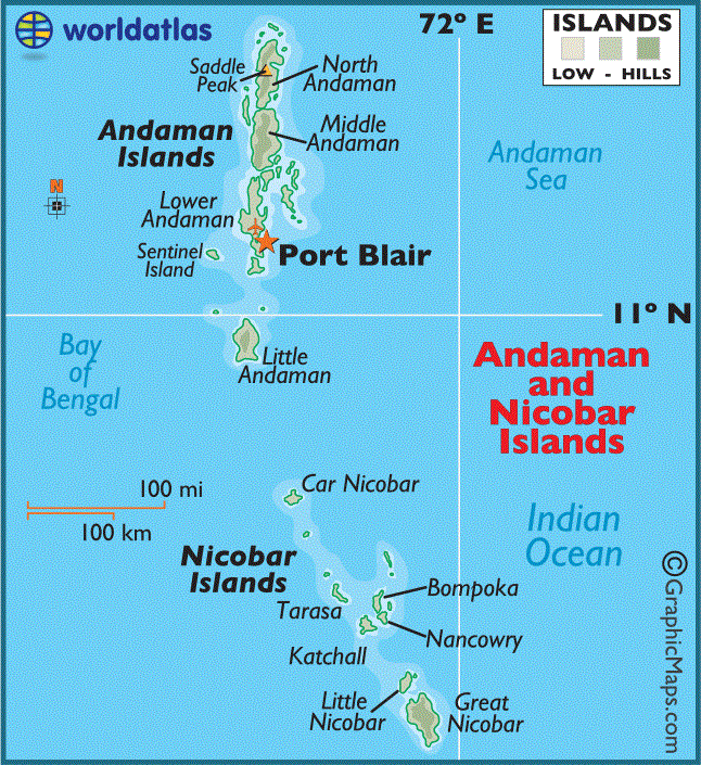
The Union Territory of Andaman And Nicobar
- The population of Andaman and Nicobar island according to census 2011 is 380,581
- There are 556 islands in the union territory of Andaman and Nicobar. Out of these 36 are permanently inhabited.
- Most islands are in the Andaman group, 26 of which are inhabited. The Nicobar Islands comprises 22 main islands (10 inhabited). The Andaman and Nicobar islands are separated by the ten degree Channel, about 150 km wide.
- The total area of Andaman Islands is about 6408 sq km, and that of Nicobar Islands approximately 1841 sq km.
- The Andaman and Nicobar islands are endowed with Tropical Rainforest. These forests consist of a mixed flora with elements from Indian, Malaysian, and Myanmarese floral strains.
- So far, about 2200 varieties of plants have been recorded, out of which 200 are endemic and 1300 do not occur in the mainland of India. Andaman forest is rich in timbers species like Gurjan and Padauk.
- About 50 varieties of mammals, 270 varieties of birds, and 225 species of butterflies are found in Andaman and Nicobar. Mount Harriet National park is one of the richest areas of butterfly and moth diversity on these islands.
- The indigenous people of Andaman are:
- The Jarawa,
- The Jangil (or Rutland Jarawa)
- The Onge, and
- The Sentinelese (most isolated of all groups).
- The indigenous people of Nicobar are:
- The Nicobarese, and
- The Shompen
- The indigenous people of Nicobar are restricted to the interior of Great Nicobar.
- A total of 48,700 hectares of land is used for agricultural purposes. Paddy, the main food crop, is mostly cultivated in Andaman group of islands. Coconut and Areca nut are the cash crops. Pulses, oilseeds, and vegetables are also grown.
- There are 1375 small-scale, village, and handicraft units. Two units are export oriented in the line of fish processing activity.
- Moreover, there are shell and wood based handicraft units. There are four mediumsized industrial units.
- The Small Scale Industrial units are engaged in the production of polythene bags, PVC conduit pipes and fittings, paints and varnished, fibre glass and mini flour mills, and soft drinks and beverages. Small-scale and handicraft units are also engaged in shell crafts, bakery products, rice milling, and furniture making.
- The Andaman and Nicobar islands integrated development corporation is actively busy in the promotion of tourism, fisheries, and industrial financing and functions as the authorised agency for Alliance Air/Jet Airways.

Lakshadweep
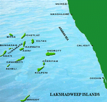
- Lakshadweep Consists of 12 atolls, 3 reefs, and 5 submerged banks, with a total of 43 islands, the Lakshadweep is located about 200 to 300 km off the coast of Kerala in the Arabian Sea.
- The total land area of the territory is 32 sq km.; eleven of the islands are inhabited. The main islands are:
- Agatti
- Pitti
- Androth
- Kavaratti
- Kalpeni
- Investigator bank, and
- Minicoy Island.
- Kavaratti is the capital of Lakshadweep.
- The total population of the territory was 64,473 according to 2011 census. The islanders are ethnically similar to coastal Kerala’s Malayalam people, and were influenced by the Arab traders.
- Inhabitants of Minicoy, the Southernmost and largest island, closely resemble Maldivians. Most of the indigenous population (about 99%) is Muslim. The locals call themselves the Div-I or Aminidivi (from the mother island). The people are largely dependent on fisheries, as soils on these coral islands are poor.
- The coral ecosystems of the islands and the scenic appeal of Lakshadweep are attracting the domestic and international tourists in a big way.
- Since such a small region cannot support industries, the government is actively promoting tourism, aquaculture and fisheries. Tourism is one of the important economic activities in these islands. These islands have been recognised as an important ecotourism place of India as a source of income.
- The Agatti Aerodrome on Agatti Island is currently the only airport in the Lakshadweep. Also, from April 2007, a private carrier, kingfisher airlines, has commenced flights to and from Agatti. Kingfisher connects Kochi and Bangalore to Agatti. The other islands are connected by a helicopter and boat service.

Sagar Island
- Sagar Island, also known as Gangasagar, lies on the continental shelf of Bay of Bengal, about 150 km south of Kolkata. The island stretches over 300 sq km and has 43 villages with a population of over 160,000.
- The island is the home to the endangered royal Bengal tiger. It is also rich in mangrove swamps, waterways, and small rivers. This land is a famous Hindu pilgrim place.
- Every year on the day of Makar Sankranti (mid of January), millions of Hindus gather to take a holy dip in the confluence of Ganga and offer puja in Kapil Muni temple. The Kolkata port trust has a pilot station and a lighthouse on this island.
- The government of West Bengal is planning to connect Sagar Island with the mainland with a 3.3 km bridge costing around INR 6,000 million.
- In addition to these, there are a number of islands around Kathiawad, Mumbai, Kochi, Tuticorin, and along the coasts of Tamil Nadu, Andhra Pradesh, Odisha, and West Bengal.
Strategy For Development Of Island Territories
- The basic problem of the indigenous people living in the islands of Andaman Nicobar, Lakshadweep, etc., is that of poverty, low standard of living, hunger, starvation, malnutrition, facilities. Moreover, they have been subjected to exploitation for centuries by the non-tribal people.
- Keeping all these considerations in view, the government of India has initiated special schemes for the development of Indian island territories. Some of the steps which may go a long way in improving the income, health, education, and quality of life of the inhabitants of the islands territories are as under:
- The economy of most of islanders, especially that of the Andaman and Nicobar Island is forest based. In order to enhance the resilient characteristics of the evergreen and deciduous forests, there is a need to bring more areas under national parks and biosphere reserves
- Many of the island territories are made of coral formations; special efforts are to be made is conserve the corals ecosystem.
- In the hot and humid climate of the Islands, the role of soil erosion is significantly high; Afforestation in the degraded lands can help to overcome this problem.
- Forest based cottage industries and handicraft can provide employment at the village level. Processing of areca nut, coconut products, and fisheries and coirmaking industries can generate appreciable employment and income to the people.
- The lush green forests, isolation, aesthetic beauty, and scenic appeal of the island are great tourist attractions. Thus, there is a great potential for the development of eco-tourism.
- There is enough potential for the development of fisheries in the coastal creeks, atolls, and bays for which special strategies need to be adopted.
The document Regional Planning and Development of Island Territories | Geography Optional for UPSC is a part of the UPSC Course Geography Optional for UPSC.
All you need of UPSC at this link: UPSC
|
303 videos|636 docs|252 tests
|
FAQs on Regional Planning and Development of Island Territories - Geography Optional for UPSC
| 1. What is regional planning and development of island territories? |  |
Ans. Regional planning and development of island territories refer to the process of designing and implementing strategies to promote sustainable growth, infrastructure development, and socio-economic progress in islands. It involves analyzing the unique needs and challenges of these territories and formulating plans and policies to address them effectively.
| 2. Why is regional planning and development important for island territories? |  |
Ans. Regional planning and development are crucial for island territories due to their distinct geographical and environmental characteristics. These territories often face challenges such as limited land availability, vulnerability to natural disasters, and reliance on specific industries like tourism. Effective planning helps in harnessing their potential, balancing development with conservation, and improving the quality of life for the residents.
| 3. What are the key components of regional planning and development in island territories? |  |
Ans. The key components of regional planning and development in island territories include:
1. Infrastructure development: Building and improving transportation networks, energy systems, water supply, and waste management facilities to support economic activities and enhance the well-being of the population.
2. Environmental conservation: Implementing measures to protect and preserve the unique ecosystems and biodiversity of the islands, including the promotion of sustainable practices and the establishment of protected areas.
3. Economic diversification: Encouraging the growth of multiple sectors and reducing dependence on a single industry to enhance resilience and promote inclusive development.
4. Social development: Ensuring access to quality healthcare, education, housing, and other social services for the island's population, with a focus on reducing inequalities and improving living standards.
5. Disaster management: Developing robust disaster preparedness and response mechanisms to mitigate the risks posed by natural disasters and climate change impacts.
| 4. How does regional planning and development contribute to the sustainable growth of island territories? |  |
Ans. Regional planning and development contribute to the sustainable growth of island territories by promoting balanced and inclusive development. It helps in optimizing the use of limited resources, protecting fragile ecosystems, and ensuring the well-being of the local communities. Through infrastructure development, economic diversification, and social investments, it creates opportunities for employment, improves living conditions, and reduces poverty. Moreover, by integrating environmental conservation and disaster management into planning processes, it enhances the resilience of island territories to climate change and other threats, ensuring their long-term sustainability.
| 5. What are the challenges faced in the regional planning and development of island territories? |  |
Ans. The regional planning and development of island territories face several challenges, including:
1. Limited resources: Islands often have limited land, water, and energy resources, which pose constraints on their development potential. This requires careful resource management and sustainable practices.
2. Vulnerability to natural disasters: Island territories are prone to natural disasters such as hurricanes, tsunamis, and sea-level rise. Planning needs to incorporate measures for disaster preparedness, mitigation, and resilience building.
3. Small economies and isolation: Many island territories have small economies and face challenges in attracting investments, diversifying their economies, and accessing markets due to their remote locations.
4. Environmental degradation: The fragility of island ecosystems makes them vulnerable to environmental degradation, including habitat loss, pollution, and climate change impacts. Planning needs to prioritize conservation and sustainable resource management.
5. Governance and coordination: Effective regional planning and development require strong governance structures, coordination among different stakeholders, and the involvement of local communities. Building these capacities can be a challenge in some island territories.
Related Searches


