UPSC Exam > UPSC Notes > Mahanadi River
Mahanadi River - UPSC PDF Download

Introduction
- The Mahanadi river originates at a height of 422 meters above mean sea level near to Pharsiya village, Nagri town in Raipur district of Chhattisgarh.
- Mahanadi river of peninsular India is one of the major inter-state east flowing rivers.
- The length of Mahanadi river from its source of origin to its confluence in the Bay of Bengal is nearly 851 Km, of which, 357 Km lies in Chhattisgarh and remaining 494 Km in Odisha.
- In Water Potential the Mahanadi river ranks second to the Godavari river among the peninsular rivers.
- The basin of Mahanadi river is bounded on various sides
- On the north by the Central India hills
- On the south & east by the Eastern Ghats
- On the west by the Maikala range.
- The Mahanadi basin spreads over an area of 1,41,589 Sq.km. which is 4.3% of the total geographical area of India and it lies in following states:
- Chhattisgarh
- Odisha
- Jharkhand
- Maharashtra
- Madhya Pradesh
Topography of Mahanadi river basin
- The upper reaches of the Mahanadi basin is on a very undulating plateau with hilllocks.
- The southern part of this plateau is open and to the east and west of it there are a number of hill ranges having steep slopes which results in water draining directly into the Mahanadi river.
- The Mahanadi basin upto Manibhadra is continuously tilt towards the main valley so no drainage congestion is experienced here.
Geology of the Basin
- The catchment area of Mahanadi river upto Manibhadra majorly consists of Archean terrain and gneiss rock formation.
- The hills have igneous and metamorphic rocks, some important types are quartzite, phyllite, quartz schist, Mica schist and granite.
- The sub-basin consists of alluvial formation of recent origin of varying thickness.
Soil and Land use
Odhisa
- The soil types found in the Mahanadi river basin are red and yellow soils mainly.
- Mixed red and black soils is found in parts of the Bolangir, Sambalpur, and Sundargarh districts of Orissa.
- Laterite soil occurs in the lower parts of Orissa.
- The coastal plains of the Mahanadi consists of the deltaic soil.
Chhattisgarh
- The main soils are Black soil and sandy soil with “Kankar” that is found in the Mahanadi basin of Chhattisgarh.
- The basin has an extensive area under forests except in the Chhatisgarh and coastal plains of Odhisa.
- Forest and agriculture are the main stay of the people in the interior parts of the Mahanadi basin.
- The Chhatisgarh and coastal plains recieveing high incidence of rainfall are predominantly rice growing areas.
Mahanadi river Tributaries
Seonath River
- The Seonath River is the longest tributary of Mahanadi river.
- Seonath River rises in an undulating region with numerous small groups of hills at an elevation of about 533 meters near Kotgal and flows for length of 383 km to join the Mahanadi river on its left near Kharghand.
- The main sub tributaries of the Seonath
On the right bank
- Kharhara
- Tandula
- Kharun
On the left bank.
- Surh
- Hanp
- Agar
- Arpa
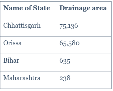
- The total drainage area of the Seonath River is nearly 30,761 sq. km. which is about 22% of the total drainage area of the Mahanadi basin.
Hasdeo River
- Hasdo River rises at a height of 915 meter at a place near to Sonhat in the Sarguja district of Chhattisgarh.
- The Hasdo river covers a length of nearly 333 km to merge into the Mahanadi river on its left near to the village Mahuadih.
- The total drainage area of the Hasdo river is 9,856 sq. km, which is about 6.96% of the Mahanadi basin area.
- The principal sub tributary of the Hasdo River is Gej River.
- Hasdo River merge into the Mahanadi River in Chandarpur in Chattisgarh, 28 km before Mahanadi river reaches the Hirakud Dam.
Mand River
- The Mand river originates at a height of 686 meters in the Sarguja district of Chhattisgarh and travels for 241 km. to reach its confluence with the Mahanadi river on its left bank near Chandarpur.
- The total catchment area of the Mand river is nearly 5,200 sq. km.
- The principal tributaries of Mand river are:
- Koirja nalla,
- Gopal nalla,
- Chhindai nalla
- Kurket river
Ib river
- The Ib River source is in the hills near Pandrapat, in the Raigarh district of Chhattisgarh State at an height of about 762 meters.
- Ib River is rain-fed river and nearly 80% of its runoff occurs during the monsoon period.
- The important tributaries of the Ib river are:
- Maina
- Sapal
- Bheden
- The total length of the Ib River is about 251 km and it falls into the Hirakud Reservoir on its left.
- The total drainage area of the Ib River is 12,447 sq. km.
Ong River
- Ong river rises at a height of 457 meters on a hill in the northern outskirts of the Gandhamardan ranges situated to the right of the Jonk River.
- The major tributaries of the Ong river are:
- Chira nalla
- Surangi
- Utalioe
- Khira.
- The Ong River travels a length of 204 km to join the Mahanadi river on its right about 11 km from Sonepur.
- The drainage area of the Ong River is about 5,128 sq.km.
- The climate of the Ong river basin is mainly dry sub-humid.
Tel river
- The Tel River have its source in the plain and open country in the Koraput district of Odhisa, nearly 32 km to the west of Jorigam.
- The Tel river travels a length of 296 km to join the Mahanadi River on the right bank, 1.6 km below Sonepur.
- Its principal tributaries are
- Udanti,
- Indra,
- Lant,
- Sutkel,
- Hatti,
- Ret,
- Uttei,
- Raul
- Khadago.
- The Tel river sub-basin is roughly rectangular in shape.
- The total drainage area of the Tel River is 22,818 sq. km. approx.
Jonk river
- The Jonk river originates in the sonabeda plateau in Nuapada district of Odhisa at a height of 700 meters.
- The Jonk river merges into the Mahanadi river near Sourinarayan upstream of the Hirakud dam, after traveling a length of about 182 km.
- The important tributaries Of Jonk river are
- Machkanalla,
- Sukha nalla,
- Kantra nalla
- Kermel nadi
- Ranidhara nalla.
- It Jonk river drains an area of about 3,484 sq.km., that is about 2.46% of the total area of the Mahanadi river basin.
FAQs on Mahanadi River - UPSC
| 1. What is the topography of the Mahanadi river basin? |  |
Ans. The topography of the Mahanadi river basin is characterized by a diverse landscape. It consists of hilly regions in the upper reaches, gradually transitioning into undulating plains and fertile agricultural lands in the lower basin. The river basin also features various tributaries, lakes, and wetlands, adding to its unique topographic features.
| 2. What is the geology of the Mahanadi river basin? | |
Ans. The geology of the Mahanadi river basin is predominantly composed of sedimentary rocks. These rocks were formed over millions of years through the deposition of sediments from rivers, lakes, and oceans. The basin is also enriched with alluvial deposits, which contribute to the fertility of the surrounding agricultural lands. The presence of sandstone, shale, and limestone formations is common in the basin's geology.
| 3. How does the topography of the Mahanadi river basin affect water flow? | |
Ans. The topography of the Mahanadi river basin plays a crucial role in determining the water flow patterns. The hilly regions in the upper reaches contribute to the significant discharge of water during the monsoon season, as the steep slopes facilitate the rapid movement of water. As the river descends into the plains, the water flow becomes more regulated, allowing for the development of irrigation canals and reservoirs to harness the water resources efficiently.
| 4. How does the geology of the Mahanadi river basin influence groundwater availability? | |
Ans. The geology of the Mahanadi river basin has a direct impact on groundwater availability. The presence of permeable rocks, such as sandstone and limestone, allows water to infiltrate and form groundwater reservoirs. These reservoirs act as natural storage and help replenish the river during dry periods. Additionally, the alluvial deposits in the basin contribute to the high groundwater potential, making it crucial for agricultural and domestic water needs.
| 5. What are the environmental implications of the Mahanadi river basin's topography and geology? | |
Ans. The topography and geology of the Mahanadi river basin have both positive and negative environmental implications. On the positive side, the diverse topography supports a wide range of ecosystems, including forests, wetlands, and aquatic habitats. This biodiversity is essential for maintaining the ecological balance and supporting various species of flora and fauna. However, the extensive human activities in the basin, such as deforestation and industrialization, have led to environmental degradation, including soil erosion and water pollution. It is crucial to manage and conserve the basin's natural resources sustainably to mitigate these negative impacts.
About this Document

4.89/5
Rating

Oct 08, 2025
Last updated
Related Exams
Document Description: Mahanadi River for UPSC 2025 is part of UPSC preparation. The notes and questions for Mahanadi River have been prepared according to the UPSC exam syllabus. Information about Mahanadi River covers topics like Introduction, Topography of Mahanadi river basin, Geology of the Basin and Mahanadi River Example, for UPSC 2025 Exam. Find important definitions, questions, notes, meanings, examples, exercises and tests below for Mahanadi River.
Description
Full syllabus notes, lecture & questions for Mahanadi River - UPSC - UPSC | Plus excerises question with solution to help you revise complete syllabus | Best notes, free PDF download
Information about Mahanadi River
In this doc you can find the meaning of Mahanadi River defined & explained in the simplest way possible.
Besides explaining types of Mahanadi River theory,
EduRev gives you an ample number of questions to practice Mahanadi River tests, examples and also practice UPSC tests.
Related Searches
shortcuts and tricks
,Viva Questions
,study material
,Exam
,Summary
,video lectures
,Mahanadi River - UPSC
,Previous Year Questions with Solutions
,practice quizzes
,Mahanadi River - UPSC
,Mahanadi River - UPSC
,Important questions
,Free
,Extra Questions
,mock tests for examination
,Objective type Questions
,Sample Paper
,past year papers
,Semester Notes
,MCQs
,ppt
;


Additional Information about Mahanadi River for UPSC Preparation
Mahanadi River Free PDF Download
The Mahanadi River is an invaluable resource that delves deep into the core of the UPSC exam.
These study notes are curated by experts and cover all the essential topics and concepts, making your preparation more efficient and effective.
With the help of these notes, you can grasp complex subjects quickly, revise important points easily,
and reinforce your understanding of key concepts. The study notes are presented in a concise and easy-to-understand manner,
allowing you to optimize your learning process. Whether you're looking for best-recommended books, sample papers, study material,
or toppers' notes, this PDF has got you covered. Download the Mahanadi River now and kickstart your journey towards success in the UPSC exam.
Importance of Mahanadi River
The importance of Mahanadi River cannot be overstated, especially for UPSC aspirants.
This document holds the key to success in the UPSC exam.
It offers a detailed understanding of the concept, providing invaluable insights into the topic.
By knowing the concepts well in advance, students can plan their preparation effectively.
Utilize this indispensable guide for a well-rounded preparation and achieve your desired results.
Mahanadi River Notes
Mahanadi River Notes offer in-depth insights into the specific topic to help you master it with ease.
This comprehensive document covers all aspects related to Mahanadi River.
It includes detailed information about the exam syllabus, recommended books, and study materials for a well-rounded preparation.
Practice papers and question papers enable you to assess your progress effectively.
Additionally, the paper analysis provides valuable tips for tackling the exam strategically.
Access to Toppers' notes gives you an edge in understanding complex concepts.
Whether you're a beginner or aiming for advanced proficiency, Mahanadi River Notes on EduRev are your ultimate resource for success.
Mahanadi River UPSC Questions
The "Mahanadi River UPSC Questions" guide is a valuable resource for all aspiring students preparing for the
UPSC exam. It focuses on providing a wide range of practice questions to help students gauge
their understanding of the exam topics. These questions cover the entire syllabus, ensuring comprehensive preparation.
The guide includes previous years' question papers for students to familiarize themselves with the exam's format and difficulty level.
Additionally, it offers subject-specific question banks, allowing students to focus on weak areas and improve their performance.
Study Mahanadi River on the App
Students of UPSC can study Mahanadi River alongwith tests & analysis from the EduRev app,
which will help them while preparing for their exam. Apart from the Mahanadi River,
students can also utilize the EduRev App for other study materials such as previous year question papers, syllabus, important questions, etc.
The EduRev App will make your learning easier as you can access it from anywhere you want.
The content of Mahanadi River is prepared as per the latest UPSC syllabus.
|
© EduRev
|
Education Revolution
|


|


Signup to see your scores
go up
within 7 days!
within 7 days!
Takes less than 10 seconds to signup